178 resultados
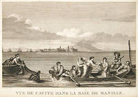
ref. 98498Paris Imprimerie de la République An V An V 1797. . First edition. 4 text vols 4to 30 x 23 cms and folio atlas 58 x 45 cms engraved portrait of La Pérouse after Tardieu atlas with engraved allegorical title-page by Moreau le Jeune titled Atlas du voyage de La Pérouse without imprint and 69 engraved plates comprising folding world map 35 views and natural history plates 33 maps or coastal profiles of which 20 double-page. Text volumes contemporary half-calf marbled boards chip to head of spine vol. I light marginal water-staining vol. II and title-page vol. III bound without half-titles joints vol. I cracked but sound lightly rubbed some scraping to boards; atlas 19th-century red morocco-backed boards neatly rebacked royal cypher of Prince Philippe of Belgium to cover and spine marginal repair to tear circa 7 cms to blank outer margin plate 15 not touching image occasional light foxing at beginning and end a very good set. The first edition of one of the most important scientific explorations ever undertaken to the Pacific and the northwest American coast and the first scientific voyage to California. 'The voyage round the world under the command of La Pérouse was intended as the French equivalent of Captain Cook's Third Voyage and was enthusiastically endorsed by the Academy of Sciences and particularly by Louis XVI. The most significant results of the voyage are the charts of the then imperfectly known Asiatic coast of the Pacific' Forbes. La Pérouse was the first explorer to navigate and chart the Japan sea and the strait between the island of Sakhalin and the northernmost island of Japan which bears his name. At Kamchatka he received instructions to proceed to Australia to assess the extent of British plans. He arrived at Botany Bay in January 1788 just hours after Governor Phillip had arrived with the First Fleet. La Pérouse's habit of forwarding copies of journals and drawings when opportunity offered ensured their survival for as is well known the accomplishments of the voyage have been overshadowed by the disappearance of the entire expedition. The folio atlas contains magnificent maps of Russian Asia Japan the Pacific North-West Coast Hawaii San Francisco and Monterey; the views include a fine series of botanical and ornithological plates including the California quail. Of particular interest to Hawaii is the plate that depicts French ships off Makena Maui. It is the first fully developed view of that island. Hill 972; Forbes 272; Lada-Mocarski 52; Ferguson 251; Brunet III 828-829; Sabin 4797. Paris, Imprimerie de la République, An V, An V [1797]. hardcover
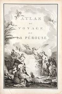
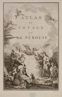
1790ref. 66877Paris. c. 1790. An extremely decorative title page featuring a huge scrolled map assorted angels and winged cherubs together with various seated and standing peoples of the world undoubtedly encountered during the La Perouse voyages. Size: 445 x 295 mm. Copperplate engraving. Good condition. unknown
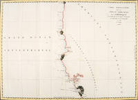
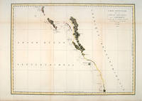
1797ref. 56360Paris. 1797. From the Voyages of La Pérouse who set sail from France in 1785 to continue the discoveries of Captain Cook. He was shipwrecked in 1788 but his narrative maps and views survived and were published in 1797. Thirty-eight years later the scattered remains of La Boussole and L'Astrolabe was discovered wrecked on a vicious reef on an atoll in the New Hebrides. Attractive sea chart covering coast from Mt. St. Elias to Monterey Bay. Relief shown by hachures. Shows route of La Perouse. Published in 'Atlas Du Voyage De La Pérouse'. Size: 575 x 845 mm. Copper engraving. Hand coloured. Very good condition; some light stains along the lower horizontal fold; a tear and some foxing to the upper margin; wide margins. unknown
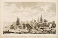
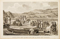
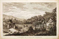
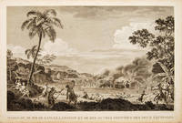
1797ref. 55666Paris. 1797. Scene showing inhabitants of Lituya Bay Alaska in fishing season. From the Voyages of La Perouse who set sail from France in 1785 to continue the discoveries of Captain Cook. He was shipwrecked in 1788 but his narrative maps and views survived and were published in 1797. Atlas Du Voyage De La Pérouse. Size: 400 x 255 mm. Copper engraving. Uncoloured. Very good condition. slight browing around edges but not effecting image. unknown
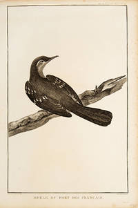
1797ref. 55672Paris. 1797. Print of an Alaskan Merle Bird. From the Voyages of La Pérouse who set sail from France in 1785 to continue the discoveries of Captain Cook. He was shipwrecked in 1788 but his narrative maps and views survived and were published in 1797. Atlas Du Voyage De La Pérouse. Size: 255 x 400 mm. Copper engraving. Uncoloured. Very good condition. Slight browing around edges but not effecting image. unknown
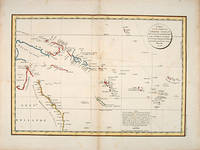
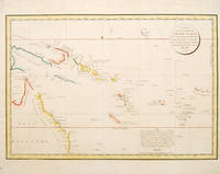
1797ref. 55868Paris: 1797. Interesting chart of part of the south-western Pacific showing the routes taken by the Spanish explorer Don Francisco Antonio Maurelle in 1781 along the northern coast of New Guinea and across the Pacific to Fiji and Tonga. Maurelle was credited with the discovery of the Hermit Islands on this voyage. The map includes the north-eastern coast of Australia and parts of the coast of New Guinea. The map shows the 1781 route of his ship "The Princesa" through the Bismarck Archipelago north of New Guinea through the Archipel de Salomos i.e. Solomon Islands and then east across the Pacific to the Iles de Amis i.e. the Friendly Islands now Tonga where he discovered I. Vavao i.e. Vava'u with one of the best anchorages in the South Pacific. The map includes the Iles de Navigateurs i.e. Samoa I. Fidji i.e. Fiji Iles de Esprit i.e. Vanuatu or the New Hebrides Isles and Nouvelle Caledonie i.e. New Caledonia. Many small islands are depicted with notes regarding their sightings by Abel Tasman William Bligh and Maurelle. A note on the chart states that the publisher has placed the islands according to the longitude of other navigators rather than on Maurelle's figures which were considered estimates only and also that Maurelles chart was based on a French chart by Jacques Nicolas Bellin published in 1742. The French cartographers at the time did not consider the Spanish charts to be sufficiently accurate so they preferred to make their own corrections. Size: 490 x 340 mm. Copper engraving. Hand coloured. Good condition. Watermark slight browning and an old repair to the central fold. Good margins. unknown
1797ref. 55667Paris. 1797. From the Voyages of La Perouse who set sail from France in 1785 to continue the discoveries of Captain Cook. He was shipwrecked in 1788 but his narrative maps and views survived and were published in 1797. Atlas Du Voyage De La Pérouse. Size: 400 x 255 mm. Copper engraving. Uncoloured. Very good condition. slight browing around edges but not effecting image. unknown
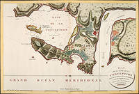
1797ref. 56362Paris: 1797. Fine sea chart of the bay and Bio Bio River region with great topographical and hydrological detail. Villages and Fort St. Pierre are depicted. From the Voyages of La Pérouse who set sail from France in 1785 to continue the discoveries of Captain Cook. He was shipwrecked in 1788 but his narrative maps and views survived and were published in 1797. Thirty-eight years later the scattered remains of La Boussole and L'Astrolabe was discovered wrecked on a vicious reef on an atoll in the New Hebrides. Copper engraving. Very good condition; slight browning to the centrefold. Hand coloured. Size: 57 x 42 cm. unknown
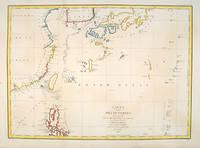
1797ref. 55879Paris:. 1797. From the Voyages of La Pérouse who set sail from France in 1785 to continue the discoveries of Captain Cook. He was shipwrecked in 1788 but his narrative maps and views survived and were published in 1797. Fine large chart shows the southern coast of China Japan Korea Formosa & the Philippines and the Marianas as well as many small islands in the region. Locates the tracks of the Boussoles the Astrolabe the ships of La Perouse on his voyage from Manila to Kamtschatka. Chart shows very detailed soundings and all known harbours straits and island chains. Engraved by BOUCLET. Atlas Du Voyage De La Pérouse Size: 675 x 490 mm. Copper engraving. Hand coloured. Fine condition. Slight browning to the lower margin. Good margins. unknown
1785ref. 53439Atlas du Voyage de la Perouse. c. 1785. Interesting chart of part of the south-western Pacific showing the routes taken by the Spanish explorer Don Francisco Antonio Maurelle in 1781 along the northern coast of New Guinea and across the Pacific to Fiji and Tonga. Maurelle was credited with the discovery of the Hermit Islands on this voyage. The map includes the north-eastern coast of Australia and parts of the coast of New Guinea. The map shows the 1781 route of his ship "The Princesa" through the Bismarck Archipelago north of New Guinea through the Archipel de Salomos i.e. Solomon Islands and then east across the Pacific to the Iles de Amis i.e. the Friendly Islands now Tonga where he discovered I. Vavao i.e. Vava'u with one of the best anchorages in the South Pacific. The map includes the Iles de Navigateurs i.e. Samoa I. Fidji i.e. Fiji Iles de Esprit i.e. Vanuatu or the New Hebrides Isles and Nouvelle Caledonie i.e. New Caledonia. Many small islands are depicted with notes regarding their sightings by Abel Tasman William Bligh and Maurelle. A note on the chart states that the publisher has placed the islands according to the longitude of other navigators rather than on Maurelle's figures which were considered estimates only and also that Maurelle's chart was based on a French chart by Jacques Nicolas Bellin published in 1742. The French cartographers at the time did not consider the Spanish charts to be sufficiently accurate so they preferred to make their own corrections. Copper engraving. Good condition. One light and one dark spot of foxing to the upper centre. A slight faint watermark. Later colour. Size: 49 x 34 cm. 19½ x 13½ inches unknown
1797ref. 558961797. From the Voyages of La Pérouse who set sail from France in 1785 to continue the discoveries of Captain Cook. He was shipwrecked in 1788 but his narrative maps and views survived and were published in 1797. Thirty-eight years later the scattered remains of La Boussole and L'Astrolabe was discovered wrecked on a vicious reef on an atoll in the New Hebrides. Engraved by Le Pagelet. Size: 250 x 180 mm. Fine condition. Some foxing to the lower margin not affecting the image. unknown
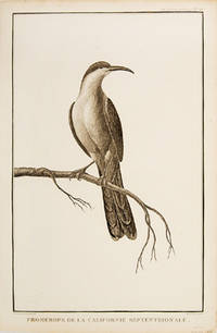
1797ref. 55673Paris. 1797. Print of a Californian Cape bird. From the Voyages of La Pérouse who set sail from France in 1785 to continue the discoveries of Captain Cook. He was shipwrecked in 1788 but his narrative maps and views survived and were published in 1797. Atlas Du Voyage De La Pérouse Size: 255 x 400 mm. Copper engraving. Uncoloured. Very good condition. Slight browing around edges but not effecting image. unknown
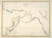
1797ref. 55870Paris: 1797. A large and imposing sea chart of the North Pacific ocean. From the Voyages of La Pérouse who set sail from France in 1785 to continue the discoveries of Captain Cook. He was shipwrecked in 1788 but his narrative maps and views survived and were published in 1797. Copper engraving. Very good condition. Watermarks. Good margins. Hand coloured. Size: 68.5 x 49.5 cm. unknown
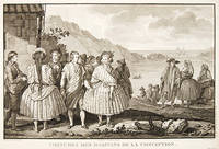
1797ref. 55650Paris. 1797. View of Chile showing the costumes of its inhabitants from the Voyages of La Perouse who set sail from France in 1785 to continue the discoveries of Captain Cook. He was shipwrecked in 1788 but his narrative maps and views survived and were published in 1797. Atlas Du Voyage De La Pérouse. Copper engraving. Very good condition. slight browing around edges but not effecting image Uncoloured. Size: 40 x 25.5 cm. unknown
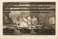
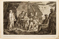
1797ref. 55669Paris. 1797. Scene showing people warming themselves by a fire in a log cabin. From the Voyages of La Pérouse who set sail from France in 1785 to continue the discoveries of Captain Cook. He was shipwrecked in 1788 but his narrative maps and views survived and were published in 1797. Atlas Du Voyage De La Pérouse. Size: 40 x 25.5 mm. Copper engraving. Uncoloured. Very good condition. slight browing around edges but not effecting image. unknown
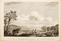
1797ref. 55670Atlas Du Voyage De La Pérouse. 1797. View of St Pierre and St Paul in Kamtschatka. From the Voyages of La Pérouse who set sail from France in 1785 to continue the discoveries of Captain Cook. He was shipwrecked in 1788 but his narrative maps and views survived and were published in 1797. Size: 400 x 255 mm. Copper engraving. Uncoloured. Very good condition. slight browing around edges but not effecting image. unknown
1797ref. 55877Atlas Du Voyage De La Pérouse. Paris: L'Imprimerie de la Republique. 1797. From the Voyages of La Pérouse who set sail from France in 1785 to continue the discoveries of Captain Cook. He was shipwrecked in 1788 but his narrative maps and views survived and were published in 1797. An attractive sea chart showing a bay at the coast of Eastern Tartary. Relief shown by hachures; depths by soundings. This is how this part of La Pérouse's journey was described in a diary: 'On 11 August they reached the southwestern point of Sakhalin Island which La Pérouse named Cap Crillon Mys Kril'on. The ships anchored near Mys Kril'on and Vaujuas went ashore where he met more Ainu people some of whom also visited the ship. The ships began to sail through the strait the next day. La Pérouse called it Canal de Castries but it would later be called La Perouse Strait.' Copper engraving. Very good condition. Faint vertical waterstains. Some very slight browning to lower margin. Good margins. Hand coloured. Size: 68 x 49 cm. 27 x 19½ inches unknown
1797ref. 55645Paris. 1797. This dramatic and attractive print is from the Voyages of La Perouse who set sail from France in 1785 to continue the discoveries of Captain Cook. He was shipwrecked in 1788 but his narrative maps and views survived and were published in 1797. Atlas du Voyage de la Perouse Copper engraving. Good margins crisp clear impression very good condition. slight browing around edges but not effecting image Uncoloured. Size: 40 x 25.5 cm. unknown
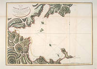
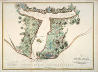
1797ref. 55881Paris: 1797. From the Voyages of La Pérouse who set sail from France in 1785 to continue the discoveries of Captain Cook. He was shipwrecked in 1788 but his narrative maps and views survived and were published in 1797. Thirty-eight years later the scattered remains of La Boussole and L'Astrolabe was discovered wrecked on a vicious reef on an atoll in the New Hebrides. Attractive sea chart showing the entrance to Port des Français. Engraved by BOUCLET. Atlas Du Voyage De La Pérouse. Size: 680 x 495 mm. Copper engraving. Hand coloured. Fine condition. Good margins. unknown
1797ref. 55652Paris. 1797. Scene showing inhabitants of Lituya Bay Alaska in native costume. From the Voyages of La Perouse who set sail from France in 1785 to continue the discoveries of Captain Cook. He was shipwrecked in 1788 but his narrative maps and views survived and were published in 1797. Atlas Du Voyage De La Pérouse. Copper engraving. Very good condition. slight browing around edges but not effecting image Uncoloured. Size: 40 x 25.5 cm. 15½ x 10 inches unknown
1797ref. 55668Atlas Du Voyage De La Pérouse. 1797. From the Voyages of La Pérouse who set sail from France in 1785 to continue the discoveries of Captain Cook. He was shipwrecked in 1788 but his narrative maps and views survived and were published in 1797. Size: 400 x 255 mm. Copper engraving. Uncoloured. Very good condition. slight browing around edges not affecting image. unknown
1797ref. 55648Atlas Du Voyage De La Pérouse. 1797. Scene showing the locals attacking voyagers as they disembark from their boats. From the Voyages of La Pérouse who set sail from France in 1785 to continue the discoveries of Captain Cook. He was shipwrecked in 1788 but his narrative maps and views survived and were published in 1797. Copper engraving. Very good condition. slight browing around edges but not effecting image Uncoloured. Size: 40 x 25.5 cm. 15½ x 10 inches unknown
1797ref. 55871Paris: 1797. From the Voyages of La Pérouse who set sail from France in 1785 to continue the discoveries of Captain Cook. He was shipwrecked in 1788 but his narrative maps and views survived and were published in 1797. Two watermarks one on each side of the islands. Engraved by Bouclet. Atlas Du Voyage De La Pérouse. Size: 680 x 495 mm. Copper engraving. Hand coloured. Very good condition. Faint waterstain on the left vertical fold and slight foxing to the upper horizontal fold not affecting the image. Good margins. unknown
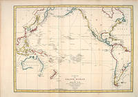
1797ref. 55869Paris: 1797. A splendid large chart of the Pacific Ocean and of those countries that border it. Only coastal information is given. From the Voyages of La Pérouse who set sail from France in 1785 to continue the discoveries of Captain Cook. He was shipwrecked in 1788 but his narrative maps and views survived and were published in 1797. Copper engraving. Very good condition. Faint waterstain along the left vertical fold. Very slight foxing not affectong the image. Hand coloured. Size: 68.5 x 49.5 cm. unknown
1797ref. 55671Paris. 1797. Scene showing local woman from Alaska. From the Voyages of La Pérouse who set sail from France in 1785 to continue the discoveries of Captain Cook. He was shipwrecked in 1788 but his narrative maps and views survived and were published in 1797. Atlas Du Voyage De La Pérouse. Size: 400 x 255 mm. Copper engraving. Uncoloured. Very good condition. Slight browing around edges but not effecting image. unknown