12.267 resultados
1954pp. vii, 311. Text maps. 8vo. Original full cloth binding. Original dust jacket, worn at extremities. AFRICA/4
36 x 48 cm. (Blatt: 47 x 57 cm). *Zeigt das Gebiet von Mecklenburg. Schönes Altkolorit. - Sauber und sehr gut erhalten. Landkarten de
34 x 44 cm. (Blatt: 45 x 55 cm). *Zeigt das Gebiet von Mecklenburg. - Breitrandig. Landkarten de
Colour printed map, ca. 810 x 608 mm. Scale: 1:1,000,000. Shows boundaries, highways and roads, railways, rivers and water features, and other details. Rare 4th GSGS edition of this map of Saudi Arabia, as part of the International Map of the World series, showing the western coastline as well as the cities Medina and Ha'il and the oasis of Al-Ula in the interior. - Stamp of ownership of Arizona State University, along with "withdrawn" and "superseded" stamps on top and next to it. - 56 mm piece of adhesive tape on top edge; pencil marks to lower right corner. OCLC 634944590. Cf. OCLC 35899626 (1962 ed.).
1653In -4° P. Pergamena, tre volumi rilegati assieme: B, (12) 191 (1 b.); 164 (appendix), 88 (epistola a Voetius, la numerazione riparte); 18 cc., 222, 3 cc. B. Nelle “Meditationes”, opera volta a stabilire cosa possa essere conosciuto con certezza, Cartesio adopera per la prima volta l’espressione “Cogito ergo sum”. L’“Appendix” si trova solitamente rilegata con le “Meditationes” ma ha un frontespizio e numerazione autonoma delle pp. così come autonoma è la numerazione della successiva Epistola al teologo olandese Voetius, suo avversario. Volume a sé (ma rilegato con questi) è i “Principia”, che fu peraltro stampato nell’anno successivo.
1983ref. 16094ANNY CHAMANT 1983 252 pages collection CARTES POSTALES ANCIENNES DE MARSE. in8. 1983. Reliure Editeur avec jaquette. 252 pages.
1998ref. vk136710/18 10-18 Cartes à jouer 1998 "Boîte (11,7 x 16,7 cm) contenant 4 mini jeux de cartes de 54 cartes (3,5 x 5,5 cm), avec sur chaque étui une couverture d'un livre de la collection 10-18 : ""Le Jeu de la Dame"" de W. Tevis, ""Mrs Felse joue en solo"" de E. Peters, ""Billy le menteur"" de K. Waterhouse, et ""Au jeu de la mort"" de N. Marsh ; très bon état. Livraison a domicile (La Poste) ou en Mondial Relay sur simple demande."
Format: 18 x 29,5 cm. *Leicht gebräunt, insgesamt gut erhalten. Landkarten de
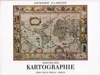
ref. 52158Berlin Gebr. Mann 1994. . Von den Karten primitiver Völker bis ins 18. Jhdt. Mit Erläuterungen zu den Abbildungen von Heinrich Winter Anmerkungen Verzeichnis der abgebildeten Karten Verzeichnis der Kartographen u. ihrer Werke Literaturverzeichnis u. Sachregister mit ca. 1500 Stichworten. - Gutes sauberes Exempöar Berlin, Gebr. Mann, (1994). unknown
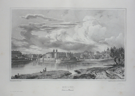
ref. LBW03d75Paris, Benard, [circa 1850]. 212 x 298 mm.
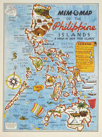
1945ref. 204557U.S.A.: Mem-O-Map Co. 1945. Colour pictographic / pictorial map 32.1 x 23.8 cms; 35.4 x 26.6 cms sheet very good condition. Rare pictorial map published in 1945 by John G. Drury aTechnical Officer who served with the 214th Ordnance Battalion to mark the end of World War II as souvenirs for the military. Military personnel could fill in banners "came in on good ship." and "departed on good ship." their name organisation and "Line of Advance or movement" blank in this example. Pictographs mark various memorable spots and wildlife including larger-than-life insects. A "Terrible Tillie Typhoon" looms over the coast at Luzon. Drury published a series of five maps: Philippines and Okinawa in 1945; Japan and Korea Oahu and Europe in 1946. They are all scarce. “These almost whimsical maps are designed to support the creation of personalised geographies. At a time when digital mapping is beginning to experiment with the creation of personalised content that would render the same map in different ways for different users Mem-O-Maps demonstrate the principle in action." Kenneth Field ICA Commission on Map Design. . Mem-O-Map Co. unknown
ref. SLIVCN-3760024990264MINUS EDITIONS
ref. 64519Editions du Rocher Editions le bridgeur 1988 livre memento 19,5*12 57 pages
ref. 24253Paris, Albin Michel, 1955. 11 x 16, 77 pp., cartonnage d'édition imprimé, bon état.
ref. SLIVCN-3760174130114BETULA
ref. SLIVCN-3760174130039BETULA
ref. SLIVCN-3760174130084BETULA
ref. 2721PHOTOTYPE BERTHAUD , sans date ( 1870 environ ) , recueil de 35 cartes , trés bon état de consevation des cartes de format 30 x 60 cm environ
1909ref. 001040LE PUY MARCHESSOU 1909 1 volume in-8 broché de 428 + LXXXIV pages , légers manque de papier aux coiffes et légères déchirures à la couverture sans manque , autrement bon exemplaire . " Dans ce volume nous trouvons un certain nombre d' études dont principalement celle de JACOTIN DES ROSIERS sur la fabrication des CARTES A JOUER du Puy paginé 87 à 183 et bien complet des 15 planches h.t. ; - C. Fabre :Pons de Montlaur dans l'histoire et dans la poésie provençale de 78 pages ; - U Rouchon : recherches sur les innondations de la Loire supérieure et ses affluents dans le département de la Haute -Loire ; etc......." Bon Couverture souple
1823Two Volumes. pp. 535; 602, (8) + Engraved title + 35 plates. With engraved illustrations in the text. Illustrated with numerous full page engravings and lithographs of views, buildings, maps, drawings, etc. One plate in hand color. Marbled endpapers. Text and plates have some foxing. Some offsetting from plates. Top edges gold. Deckle edges. 4to. 290 mm. Half leather over marbled boards. Raised bands. Spines decorated and lettered in gold. Inked ownership of Miss Ann Willcox on top of preface pages and elsewhere. Bookplate of Redmond Conyngham in both volumes. Redmond Conygham (1781-1846) was born in Philadelphia. He inherited from his paternal grandfather an estate in the county Donegal, Ireland, yielding L2,000 a year, and subsequently spent some time in Ireland. During his stay abroad he became intimate with Curran, Grattan, and other prominent Irishmen, including his cousin, William Conyngham Plunket, afterward lord-chancellor of Ireland. On his return to the U.S. he settled in Luzerne County, Pennsylvania, and was active in state and local politics. He then removed to Lancaster County, where he devoted much of his leisure to antiquarian research. Issued as a limited edition, less than 500 copies were printed. A very good copy of this handsome and informative book. Scarce. **PRICE JUST REDUCED! LivRm
1880Four Volumes. pp. 596; 577; 691; 713 + Folded two page map of Boston in color, and other illustrations, maps etc. 4to. Original full cloth binding; somewhat worn and stained. XLib. Skidompha Library, Damriscotta, ME. **PRICE JUST REDUCED! NEW ENG 4
Zaragoza, IFC, 2008. Folio; 7 pp., 14 láminas y 16 grandes mapas plegados. Encuadernación original en cartoné.
1953186 pages, illustrated, maps on the endpapers, index. eng
1980ref. 7770AKeine weiteren Angaben. Um 1980. 4°. Ca. 60 nn. S. mit Abb. in S/W. Geklammerte Broschur.