With Maps and DiagramsBiblio.com
The Great War Book
ref. 1330383230.Gpaperback. Good. Access codes and supplements are not guaranteed with used items. May be an ex-library book. paperback
Bonita · Estados Unidos55,21 US$≈ 49,33 €
12.210 resultados
1961ref. UCARGRE00hcBobbs-Merrill 1961. Very Good. Caruso John Anthony. The Great Lakes Frontier: An Epic of the Old Northwest. Mitchell maps Francis J. Indianapolis: Bobbs-Merrill 1961. 432pp. Indexed. Illustrated. Bibliography. 8vo. Cloth. Book condition: Very good with previous owner's name on front endsheet. Dust Jacket Condition: Good with rubbed bumped and chipped edges. Bobbs-Merrill hardcover books
1990320 pages. Presents decoys in the most sensible and comprehensive way: by region, with each region discussed by a recognized expert in that area. Thus the entire range of decoys is covered, from Canada down the Atlantic Coast and inland along streams and rivers to Louisiana and up the Mississippi to the Great Lakes and across to California and Oregon. Also included are chapters on European decoys, the history of decoys, how decoys were made, and how to go about collecting decoys. A list of public collections of decoys, a bibliography, a record of top auction prices, maps of waterfowl flyways, and an index complete the package. Beautifully illustrated with colour photography throughout. Gift greetings upon front endpaper else book clean, bright and unmarked with very light wear. Dust jacket bears tape-repaired tear to central portion of front panel and large chunk missing from base of back flap. A small part of this chunk is from bottom corner of back panel. Other than this, dust jacket is bright and attractive with moderate wear. Overall, a nice copy of this most substantial work. Book
ref. 1330383230.Gpaperback. Good. Access codes and supplements are not guaranteed with used items. May be an ex-library book. paperback
1923Pages 197-249. Black and white photos. Features: Nice full-page photo portrait of Major Charles S. Walker, N.H. Department Commander American Legion; For God and Country - The American Legion - A New Hampshire Asset - major article with many great photos; The Legion - Maker of Americans - an interview with Maurice F. Devine; Behind the Lines; Behind the Lines - The American Legion Auxiliary at work; State Executive Board of the American Legion Auxiliary; A Portrait Gallery of Legionnaires - excellent photos with write-ups of selected individuals; New Hampshire's Labor Commissioner; Their Son; An Anthology of One Poem Poets; Over the Top with Ayrshires - The Sawyer Herd and Farrm Buildings - article with nice photos; In the Springtime; When Claremont was called Ashley III - Two English Maps of Revolutionary Times; Current opinion in New Hampshire; Old Home Week and the Tercentenary; Books of New Hampshire Interest; The Editor Stops to Talk; New Hampshire Necrology. Average wear and soiling. A sound vintage copy of this particularly excellent issue. Magazine
2007Book appears in mint unread condition. 575pp. Architect Harry Seidler spent more than 50 years traveling the globe, extensively photographing the peak achievements in architecture from 3000 B.C. to the present day. This book represents his achievement.
1759ref. 848041759. T. Kinnersley. London. 1759. In Two Volumes II and III and contains the whole set for the year 1759. Bound in 18th century quarter brown calf gilt very worn and rubbed and lacking portions of leather from heads and tails of spine. Joints tender but holding. Vol. II; ii 372 pages plus 4pages of index. Vignette to general title-page and engraved head-piece for each month. 6 engraved plates of unusual and more ordinary fauna including the dodo the rhinoceros sea hedge-hog the horned didapper flying fish and cassowary. 1 portrait plate of Magliabechi 14 full page engraved maps and plans. Vol. III; ii. 404 pages plus 4 page index. Engr. vignette to general title-page and engraved head-pieces or decorations to each month 4 engraved plates of fauna one portrait plate of Major General Wolfe 1 incredible engraved plate displaying the Torments Inflicted by the Dutch on the English in Amboyna plus the engraved frontis. to Pope's Essay on Man. Three engraved plates - 1 map and 2 plans. A wonderful insight into what interested people in the mid-18th century. Pages browned and occasionally foxed but otherwise a very useful set. hardcover
ref. 0243147651.Gpaperback. Good. Access codes and supplements are not guaranteed with used items. May be an ex-library book. paperback
ref. 0259994545.Gpaperback. Good. Access codes and supplements are not guaranteed with used items. May be an ex-library book. paperback
ref. 1334235430.Gpaperback. Good. Access codes and supplements are not guaranteed with used items. May be an ex-library book. paperback
ref. 1527709027.Gpaperback. Good. Access codes and supplements are not guaranteed with used items. May be an ex-library book. paperback
2005No inscriptions or marks. No creasing to covers or to spine. A very clean crisp tight copy with bright unmarked boards, very slight traces of handling and no bumping to corners. 64pp. A brief history of Dublin, a guide and map to the city.
1995ref. SBBI-mon0000023520Goldeneye 1995. map. Acceptable. Water damage to book. Please see the condition note after this for details if this is missing please consider Acceptable to mean poor quality that could include major staining water damage writing missing dustjacket etc etc. Our books are dispatched from a Yorkshire former cotton mill. We list via barcode/ISBN so please note that the images are stock images and may not be the exact copy you receive furthermore the details about edition and year might not be accurate as many publishers reuse the same ISBN for multiple editions and as we simply scan a barcode or enter an ISBN we do not check the validity of the edition data when listing. If you're looking for an exact edition please don't order at least not without checking with us first although we don't always have time to check. We aim to dispatch prompty the service used will depend on order value and book size. We can ship to most countries see our shipping policies. Payment is via Abe only. Goldeneye unknown
1941ref. 48041Minneapolis MN: Global Map Co. ca. 1941. Oblong folio 22.5 x 11.25 in. Two rotating wheels each showing hemisphere projection maps which are attached to a thick brown base w/ printed labels on front cover original rivets still present printed paper label and instructions on verso some rubbing & edgewear minor foxing & scuffing still a G exemplar. First edition of this fascinating and scarce global map which allows the user to view steamship or airline distance routes as well as the principal railroads. The global map was designed so that opposite halves of the earth’s surface could be rotated and synchronized enabling continuous and accurate spherical relationships across any point on the rotating maps. The label on the back lists the area in square miles and population totals of the world. The map is dated to around 1941 because of the inclusion of Vichy France the government allowed by the Nazi occupiers after the fall of France in 1940. Global Map Co., unknown
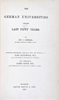
1885ref. 30824Glasgow: David Bryce & Son 1885. First English language edition. Hardcover. g. Quarto. XXX 333 1 3pp. Original red cloth with gold lettering on spine. The present work is a captivating survey of the German Universities for the last 50 years between 1835 and 1885. It forms the second part of the third volume of a series of statistical inquiries in various departments of the national economy of Germany conducted by Dr. Conrad Professor of Political Science at Halle. Minor age wear on binding with spine slightly age toned. Previous owner's signature in ink on half-title page and dated 1885. Very minor age toning along paper margin. Binding and interior in overall good condition. David Bryce & Son hardcover books
1917220p. + Plus six folding maps and numerous full page photographs. 8vo. Original full pictorial wraps, very slightly worn. First American edition. Nice copy. WWI 7
1885ref. 30824Glasgow: David Bryce & Son 1885. First English language edition. Hardcover. g. Quarto. XXX 333 1 3pp. Original red cloth with gold lettering on spine. The present work is a captivating survey of the German Universities for the last 50 years between 1835 and 1885. It forms the second part of the third volume of a series of statistical inquiries in various departments of the national economy of Germany conducted by Dr. Conrad Professor of Political Science at Halle. Minor age wear on binding with spine slightly age toned. Previous owner's signature in ink on half-title page and dated 1885. Very minor age toning along paper margin. Binding and interior in overall good condition. David Bryce & Son hardcover
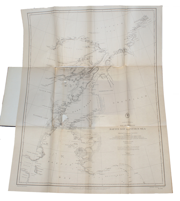
1885(New York, 1885). 4to. In later half cloth with gilt lettering and stamp to front board. In ""Science"", Vol. 5, No. 108, Feb. 27. Paper label pasted on to front board. The two titles underlined in blue pencil. Stamp to verso of map and almost parted in two, long tear in foldings, otherwise internally fine and clean. Pp. iii-iv, 163-185 + large folded map: ""North America polar regions : Baffin Bay to Lincoln Sea, showing the most recent discoveries including those of U.S.S. Polaris Expedition in 1871-2, under Captain C.F. Hall, British Arctic Expedition in 1875-6, under Captain G.S. Nares, R.N., The Lady Franklin Bay Expedition in 1881-4, under Lieutenant A.W. Greely, U.S.A""
1885ref. 58309(New York, 1885). 4to. In later half cloth with gilt lettering and stamp to front board. In ""Science"", Vol. 5, No. 108, Feb. 27. Paper label pasted on to front board. The two titles underlined in blue pencil. Stamp to verso of map and almost parted in two, long tear in foldings, otherwise internally fine and clean. Pp. iii-iv, 163-185 + large folded map: ""North America polar regions : Baffin Bay to Lincoln Sea, showing the most recent discoveries including those of U.S.S. Polaris Expedition in 1871-2, under Captain C.F. Hall, British Arctic Expedition in 1875-6, under Captain G.S. Nares, R.N., The Lady Franklin Bay Expedition in 1881-4, under Lieutenant A.W. Greely, U.S.A""
ref. 244229[London, Burgis & Barfoot], (1841) 42 x 56 cm, encadrée sous verre (encadrement postérieure). Pliure centrale.
1872Two volumes. pp. xvii, 510; 511-956 + Plus 12 colored folding maps + Five steel engraved plates + Engraved illustrated title page. Numerous woodcut illustrations in the text. 8vo. Worn original full leather bindings. A thorough delight for the Victorian arm chair traveller. This American edition is rather scarce. **PRICE JUST REDUCED! W156
1902Outside dimensions 14.5" x 10.5". Circa 1902. Centerfold. Light wear. Please see our photo for details. Book
1972No marks or inscriptions. A very clean very tight copy with bright unmarked boards and no bumping to corners. Dust jacket not price clipped or marked or torn or creased with very minor traces of storage. 172pp. With nearly 150 illustrations, many in colour, this account describes China's Forbidden City which only became accessible to all Chinese citizens after the 1911 revolution.
1994Booklet is 'as new' condition. 48pp. The history of the prehistoric cave paintings at the Font-de-Gaume cave near Les Eyzies in Perigord, France.
1976No marks or inscriptions. No creasing to covers or to spine. A very clean very tight copy with bright unmarked boards and bumping to upper front corner and spine ends. 32pp. Captioned colour photographs of the Flinders mountain range near Adelaide, South Australia.
ref. 351255Art & Educational Publishers 1946. Octavo black buckram boards gilt lettering to spine gilt military insignia to front board frontispiece xv 192pp illus/photos VG light bruising to extrems sl chafing to boards light tanning & foxing to page edges & eps occasional light soiling throughout Art & Educational Publishers 1946 hardcover