Singleton, DavidMareMagnum

12.228 resultados
1974Ex-library book with usual marks and stamps. A clean tight copy with no bumping to corners. Dust jacket not price clipped or torn or creased with slightly faded spine. 96pp. How our growing leisure time is changing the landscape of the region. Focus on England's North West
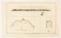
1784ref. 174896London.: Alexander Hogg at the King's Arms. circa1784. Engraved map in triptych on laid paper 20.1 x 32.7 cm three insets: cross section of the north side of Queen Charlotte's Islands Solomon Islands with detail of a volcano "6 leagues North"; Swallow's Bay Harbour; and Byron's Harbour early hand colour trimmed to the plate mark at the top edge neat sealed tear affecting the publisher's caption slight edge wear and paper toning but a most attractive map in very good condition. Attractive engraving of the Queen Charlotte's Islands Solomon Islands. The Islands were named for the consort of King George III by Philip Carteret the British naval officer and explorer who participated in two of the Royal Navy's circumnavigation expeditions in 1764–66 and 1766–69. His ship the Swallow gave her name to the Bay and Carteret's commanding officer on the first of his voyages John Byron to the Harbour depicted in this most attractive early chart. . Alexander Hogg at the King's Arms. unknown
1947pp. xii, 619 + Maps and photographs. Paper beginning to brown but not brittle. 8vo. Original full cloth binding. Original dust jacket, very slightly worn. Hardbound. Reprint of the 1937 Viking Press edition. HOLY LAND BOX 1
1975No marks or inscriptions. A very clean very tight copy with bright unmarked boards and minor bumping to some corners. Dust jacket not price clipped or marked or torn with minor creasing to edges and slight indenting to rear. 192pp. The culture, the people, the places, the history of New Zealand, described by the author and very well illustrated by photographs from Smith and Jacobs.
1920ref. 52936Syracuse NY: Empire New England Company Inc. ca. 1920. Double Elephant folio. 51 x 59 in. Large colour-printed map dissected and mounted on linen backing brass grommets at upper fore-edge for hanging title stamped on verso minor edgewear at creases very minor lifting at seams minor dustsoiling to outer linen when folded still a VG exemplar. First edition thus of this scarce education map of post-World War I South American geography. The map details the principal railways water routes major cities steamship routes and geographical and political details. The Empire New England Company was active in upstate New York from about 1915 until the end of the 1920s selling educational supplies maps textbooks and more. The New World School Maps could be purchased individually or in cases which held between 6-10 individual maps for school uses according to company literature of the period. Worldcat locates 1 copy Buffalo & Erie County Public Library smaller size - 1931 ed. Empire New England Company, Inc., unknown
1839London, Laurie, 1839. 8vo. In contemporary blank wrappers with part of original printed wrapper pasted on. Stamp to front wrapper and title-page. Internally fine and clean. iv, 38 pp.
1963IN HEBREW. 28.5X32.5 cm. 130 pages. Hardcover. Contains black and white and color plates. Cover slightly dirty and stained. Cover edges slightly creased. Spine slightly wrinkled. Edges of several pages slightly creased. Pen writing on first white page. Else in good condition.
1995ref. 50867Oxford : Clarendon Press, 1995. XXII, 314 S. (23,5 cm) Broschierte Ausgabe
1993ref. 50884Oxford : Clarendon Press, 1993. XXII, 314 S. (23,5 cm) Broschierte Ausgabe
1978No marks or inscriptions. A very clean very tight copy with bright unmarked boards and no bumping to corners. Dust jacket not price clipped or marked or torn with sunned spine and a little creasing to edges. 320pp. A comprehensive reference to the National Trust's houses, castles, gardens, islands, historic sites and the people associated with them.
1976298 pages including index. Compiles all available references relevant to the environmental aspect of the Nanaimo River Estuary. Summarizes pertinent information and provides lists on plant and animal life, to provide readers with some idea of the ecological characteristics. Contents include topics such as: Geology; Economic Geology; Surficial Geology; Climatology; Hydrology; Oceanography; Invertebrate Biology; Invertebrate Fisheries Resource; Flora; Wildlife; Land and Water Use; Pollution; plus an extensive Bibliography. Includes a variety of maps. Report of the Estuary Working Group, Department of the Environment, Regional Pacific Region. Clean and unmarked with moderate wear. Binding sound. A wonderful reference. Book
ref. SONG1851376283Hweryho 2019-10-18. 1st edition 2019. hardcover. Used: Good. 8.27x0.98x9.84. Buy with confidence. Excellent Customer Service & Return policy. Hweryho hardcover
ref. DADAX1851376283Hweryho 2019-10-18. 1st edition 2019. hardcover. New. 8.27x0.98x9.84. Buy with confidence. Excellent Customer Service & Return policy. Hweryho hardcover
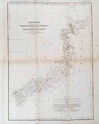
1878ref. 210211Philadelphia.: American Institute of Mining Engineers. Sherman & Co. printers. 1878. Large folding map of Japan showing "some of the more important Mining Districts Coal Fields etc." small fold split without loss tables 67pp. Covers a little scuffed and discoloured overall in very good condition. Scarce offprint separately paginated of a paper included in Volume V of the Transactions of the American Institute of Mining Engineers. The author Henry S. Munroe had been retained by the Japanese Government as Assistant Geologist and Mining Engineer with the Geological Survey of Yesso for the Hokkaidō Colonization Agency. His work laid the foundations for the future coal mining industry in Hokkaido. The report contains two lengthy tables relating to coal production and quality. . American Institute of Mining Engineers. Sherman & Co., printers. unknown
19771 folded map. VG. (National road maps ; 3). 18875. eng
ref. 0332212777.Gpaperback. Good. Access codes and supplements are not guaranteed with used items. May be an ex-library book. paperback
ref. 2067184997.Ghardcover. Good. Access codes and supplements are not guaranteed with used items. May be an ex-library book. hardcover
1948ref. TOB217-32701-A-0.50Doubleday. Good with no dust jacket. 1948. Hardcover. 309 pages; Copyright page does not state edition or printing. Likely 1st edition judging from date. Foxing heavy to the exterior edge of pages only. Yellowing to pages. Otherwise in good condition. No writing or major blemishes. ; - We're committed to your satisfaction. We offer free returns and respond promptly to all inquiries. Your item will be carefully wrapped in bubble wrap and securely boxed. All orders ship on the same or next business day. Buy with confidence. . Doubleday hardcover
2007152 pages. Bibliography. Index. Wonderfully illustrated, often in colour. Printed upon glossy stock. Handsomely produced. "Plot's Nova Scotia's growth through the careful examination and analysis of maps from the nineteenth century. An exciting time in Nova Scotia's history, this period saw the first serious attempts to gain knowledge of the entire province, its resources and its inhabitants. Traces developments in our province that today are taken for granted." - from back cover. Clean, bright and unmarked with light wear. A high-quality copy. Book
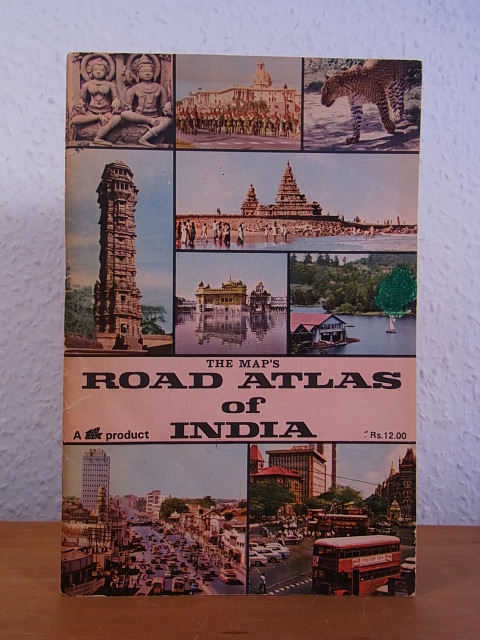
1982ref. 99394TPT - Tamilnad Printers and Traders (formerly Maps & Atlases Publications), Chromepet, Madras, 1982. 22 cm ; broschiert
196032 pages. A story which teaches young readers about mapmaking. Front free endpaper removed. Usual library markings. Worthy working copy. Book
1980No marks or inscriptions. No creasing to covers, minor crease partway down spine. A clean very tight copy with lightly sunned covers and no bumping to corners. Minor bump to bottom of spine. 160pp. This volume presents selections of the text from Morton's classic 'In Search of Ireland' dated 1930 complemented with a wealth of colour and monochrome photographs of modern Ireland.
1946A magazine for collectors and others interested in times past and in articles of daily use and adornment devised by the forefathers. Features: Cover illustration of Maypole Dance on English textile c. 1765; Potter (Meissen porcelain figure, c. 1750) frontispiece; The Goddard and Townsend Joiners - Part II; Styles in Silver; Two Looking Glasses; Capodimonte and Buen Retiro Porcelain; Old Maps - And The Men Who Made Them; Living with Antiques - The Charleston Home of Josephine Pinckney; A Painted Wall in the home of Charles Howard in Fitchburg, MA; and more. Many pages of nostalgic ads from a broad assortment of prominent dealers. Profusely illustrated with excellent black and white photos. pp. 265-328. Printed upon glossy stock. Unmarked with above-average wear. Covers loose but present. A worthy reference copy of this informative issue. Book
2002No marks or inscriptions. Small crease to upper corner of rear cover. A very clean very tight copy with bright unmarked boards and no bumping to corners. 73pp. The essential guide to the Gardens & wider estate near St Austell in Cornwall.
191658p. + Full page plates. Age stained. Small 4to. Original pictorial wraps, soiled. PA PAMPH 20_3 BX3