Drioux, JosephBiblio.com

ref. 1168463858.Gpaperback. Good. Access codes and supplements are not guaranteed with used items. May be an ex-library book. paperback
ref. 1271432455.Gpaperback. Good. Access codes and supplements are not guaranteed with used items. May be an ex-library book. paperback
ref. 116100159X.Gpaperback. Good. Access codes and supplements are not guaranteed with used items. May be an ex-library book. paperback
ref. 116677922X.Gpaperback. Good. Access codes and supplements are not guaranteed with used items. May be an ex-library book. paperback
ref. 1120494621.Gpaperback. Good. Access codes and supplements are not guaranteed with used items. May be an ex-library book. paperback
ref. 2019248387.Gpaperback. Good. Access codes and supplements are not guaranteed with used items. May be an ex-library book. paperback
ref. 1142913619.Gpaperback. Good. Access codes and supplements are not guaranteed with used items. May be an ex-library book. paperback
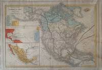
1870ref. 338860Paris: Eugene Belin 1870. Map. Lithograph with hand coloring. Image measures 12 3/4" x 16 3/4". This detailed map of North America was published in the "Atlas Universel Et Classique De Geographie". Created by Claude-Joseph Drioux and Charles Leroy it features two prominent insets as well one depicting the voyages of Christopher Columbus and another focusing on Mexico. Below the title is an index listing 18 states with West Virginia also noted as "Kanawha." Texas Louisiana Mississippi Arkansas Oklahoma and California have their borders delineated. Montana is also labeled as "Shoshone" and "Mormons" is written over Utah. The Transcontinental Railroad is shown and the Gulf Stream and the South Equatorial Current are depicted.Toning at margins and on right side of image otherwise good condition. Eugene Belin unknown books
ref. 68-5666Paris France: Belin 1867. Atlas. Folio. Three Quarter Black Gilt Leather on Marbled Boards. 76 maps some color. Marbled End Papers. Good with tears to spine loose pages corners worn to boards. En Francais. Paris, France: Belin, 1867. hardcover
1870ref. 338860Paris: Eugene Belin 1870. Map. Lithograph with hand coloring. Image measures 12 3/4" x 16 3/4". This detailed map of North America was published in the "Atlas Universel Et Classique De Geographie". Created by Claude-Joseph Drioux and Charles Leroy it features two prominent insets as well one depicting the voyages of Christopher Columbus and another focusing on Mexico. Below the title is an index listing 18 states with West Virginia also noted as "Kanawha." Texas Louisiana Mississippi Arkansas Oklahoma and California have their borders delineated. Montana is also labeled as "Shoshone" and "Mormons" is written over Utah. The Transcontinental Railroad is shown and the Gulf Stream and the South Equatorial Current are depicted.Toning at margins and on right side of image otherwise good condition. Eugene Belin unknown
2026ref. LRB1006952Paris: Editions Recreasoft 2026 Idioma: Español. Aproximadamente 571 páginas. Español : Reimpresión bajo demanda. Edición original : 1858. de 1858. Compendio de historia moderna que recorre los grandes acontecimientos desde la toma de Constantinopla hasta la caída del Imperio napoleónico. Obra de síntesis de interés para la historia política y europea del periodo moderno con enfoque cronológico y panorámico útil para lectores coleccionistas e investigadores interesados en la historiografía del siglo XIX. Imágenes del libro no contractuales English : Print-on-demand reprint. Original edition : 1858. from 1858. A concise survey of modern history covering the major events from the fall of Constantinople to the collapse of Napoleon's Empire. A work of synthesis of interest for the political and European history of the modern period with a chronological and panoramic approach useful for readers collectors and researchers interested in nineteenth-century historiography. Book images are non-contractual. Editions Recreasoft. Softcover. New. Editions Recreasoft paperback
ref. 1160056013.Gpaperback. Good. Access codes and supplements are not guaranteed with used items. May be an ex-library book. paperback
ref. 116770519X.Gpaperback. Good. Access codes and supplements are not guaranteed with used items. May be an ex-library book. paperback
ref. 1271431807.Gpaperback. Good. Access codes and supplements are not guaranteed with used items. May be an ex-library book. paperback
ref. 1168108772.Gpaperback. Good. Access codes and supplements are not guaranteed with used items. May be an ex-library book. paperback
ref. 1160842264.Gpaperback. Good. Access codes and supplements are not guaranteed with used items. May be an ex-library book. paperback
ref. 2012797121.Gpaperback. Good. Access codes and supplements are not guaranteed with used items. May be an ex-library book. paperback
ref. 0282973400.Gpaperback. Good. Access codes and supplements are not guaranteed with used items. May be an ex-library book. paperback
ref. 17-3070Paris: Eugene Belin 1886. Original color engraved map. Oblong. 18.5 x 13 inches. Very Good. Minor edge wear. Vertically folded along center. Text in French. Light matting. Paris: Eugene Belin, 1886. unknown
ref. 232923788X.Gpaperback. Good. Access codes and supplements are not guaranteed with used items. May be an ex-library book. paperback
ref. 2012754341.Gpaperback. Good. Access codes and supplements are not guaranteed with used items. May be an ex-library book. paperback
ref. 1021831832.Gpaperback. Good. Access codes and supplements are not guaranteed with used items. May be an ex-library book. paperback
1877ref. LRB636Paris: Librairie Classique d'Eugène Belin 1877 Paris: Librairie Classique d'Eugène Belin 1877 Titre : Atlas universel et classique de géographie ancienne romaine du Moyen Âge moderne et contemporaineAuteur : Drioux B. - Leroy Ch.Éditeur : Librairie Classique d'Eugène BelinLieu d'édition : ParisDate d'édition : 1877Édition : Nouvelle éditionReliure : Demi-basane rouge de l'époque plats marbrés in-folioFormat : env. 37 x 28 cmLangue : françaisIllustrations : 88 cartes et cartons annoncés planches de cosmographie planisphère céleste nombreuses cartes en noir et en couleurs pastelDescription de l'exemplaire :Reliure d'époque avec frottements d'usage coins émoussés petites épidermures.Faux-titre et page de titre fortement froissés avec déchirures et manques en marge inférieure droite ; quelques restaurations anciennes possibles.Rousseurs éparses plis et déchirures marginales ponctuelles dans le corps de l'ouvrage ; quelques annotations anciennes au crayon.Ancienne signature manuscrite 'G. Barthélémy' sur les premiers feuillets.Intérieur composé de grandes planches doubles comprenant cosmographie planisphère céleste et cartes historiques ex. Égypte ancienne certaines en teintes. Nouvelle édition. Good. Nouvelle édition. Good. Librairie Classique d'Eugène Belin hardcover
1910ref. 456457Paris : Librairie classique Eugène Belin 1910. New Edition. Hardcover. Good copy in red buckram boards backed in red leather with raised bands; spine gilt-blocked with title and decoration in the compartments. Panel edges slightly rubbed with joints and spine bands rather more worn and slight loss to the spine's head. Remains tight with an internally clean impression; very faint scattered foxing only. A single folded map political and physical of France is slightly torn at the edges but entirely serviceable. A very well-preserved copy overall. Physical description; 1 atlas vii 106 leaves : colour maps ; 34 cm folio. Notes; Contains 229 coloured maps and inset maps seven explanatory legends and nineteen legends of economic geography. Cartographic data: Scales differ. Subjects; Historical geography - Maps World history - Maps Atlases French - 20th century. Paris : Librairie classique Eugène Belin hardcover
1882ref. 78758Paris: Librairie classique Eugène Belin 1882. Contemporary half leather spine with ribbons with gilt title; covers with decorated paper rubbed corners damaged borders rubbed with loss of paper. Halftitle title and 4 pp. "Avertissement". The first 8 pages paper of bad quality age-toned with spots stamp tears and repaired inner hinge . On verso title "Table des cartes". With 88 maps on 67 leaves double-page maps 2 on 1 double-page leaf sectionary maps and large folding map of France. According to the table with 69 maps complete.- Including double-page planispheres - cosmographie - mappe-monde - Schoolbook with a few small inkspots on maps and brown spots in places. Librairie classique Eugène Belin hardcover