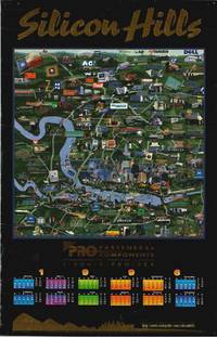
ref. 12934Austin: Civic Pride Inc. / Clarke Printing 1995. Color printed map on sturdy glossy paper 37.5 x 24 inches with the title sponsor and footer printed in embossed gold foil. Some short heavy creases and rubbing in image area moderate edge wear pinholes in corners. Still very good condition. An eye-catching poster map of Austin Texas in the fledgling years of its tech boom and a very obvious product of the 1990s. Apart from the 1996 calendar at the bottom the poster features rudimentary Photoshop elements and numerous dot-com bubble companies peppered among technology companies that survive to this day. The sponsor of the map is printed between the bottom of the map and the calendar Pro Fasteners and Components on Springdale Road. Austin's identity as "Silicon Hills" began around this period with local business groups hoping to replicate the economic vibrancy enjoyed by the Bay Area's Silicon Valley in earlier decades. The map identifies dozens of companies using an interesting mix of logos corporate headquarters and photographs of actual employees. Some of the imagery is amusing to a larger audience while other images would likely be recognizable strictly to a local audience. The geographic inaccuracies are waved away with a humorous note in the lower right: "Warning.Reality Bytes. So it has nothing to do with this poster." The map was designed by Art Director Mark Bruneman and published in Austin in 1995 by Civic Pride Inc. The firm was acquired by Silicon Maps which continues to create similar productions of tech-heavy areas today. Different versions of the present map were apparently issued in the late-1990s. OCLC reports just a single institutional copy of any version of the map issued in 1997 by Civic Pride and held in the Rumsey Collection at Stanford. Civic Pride, Inc. / Clarke Printing unknown books
ref. 12909San Jose CA: Gist & Erdmann Inc. / Panoramic Map Productions 1989. Color printed map on sturdy glossy paper 39 x 26.75 inches. Small piece of old cellophane tape in the upper margin tiny puncture in image area near top-middle portion of the map lightly wrinkled previously rolled. Overall in very good condition. A rare and charming 1989 pictorial cartoon map and calendar of Silicon Valley illustrated by Pham Bach Phi one of at least three such works produced by the artist during the tech boom of the late 1980s and early 1990s. Copyrighted and published as a joint venture between Gist & Erdmann Inc. and Panoramic Map Productions the view employs an inviting almost pastoral aesthetic that deliberately downplays the burgeoning urban sprawl brought on by the explosion of the computer industry. By depicting major freeways as rustic roads and rendering corporate headquarters in a modest commercial style the artist fosters a small-town atmosphere in a region that was at the time undergoing a radical industrial transformation. The poster is populated with company logos and vignettes that celebrate a local economy rapidly centralizing around the technology sector. Notable names include Oracle IBM Apple and Hewlett-Packard practically a "Who's Who" of the era's digital vanguard. The bottom portion of the work is printed with a calendar for the upcoming year of 1990 underscoring the item's original purpose as a functional office product in itself. The year 1990 like most years since the '70s marked the dawn of the digital era in Silicon Valley highlighted by Tim Berners-Lee installation of the first World Wide Web server on a NeXT computer -- Steve Jobs' post-Apple venture -- at CERN. The year also saw the launch of LambdaMOO at Xerox PARC the inaugural Photoshop Invitational in Mountain View and key early developments in 3D graphics and networking that set the stage for the dot-com boom and current computer technologies. Gist & Erdmann, Inc. / Panoramic Map Productions unknown books
1554ref. 13800Venice: Pinio Pietrasanta 1554. FIRST EDITION. Title within elaborate architectural border separate leaf with portrait of the author 17 decorative woodcut initials and 8 woodcut text illustrations 5 full-page. Bound in decorative modern boards. Other than a couple of very small and mild damp stains a lovely large copy. First edition of the first Italian book devoted exclusively to fortification of cities. It was preceded only by Durer’s Etliche underricht zur befestigung der Stett 1527. Italian works by Valle 1521 and Cataneo and Tartaglia both 1554 contained only chapters on the subject. Zanchi 1515-1586 a military engineer in the Venitian service under Marcantonio Colonna took part in several campaigns including the long siege of Siena where he became acquainted with Belluzzi and was a friend of Girolamo Maggi. He remarks that “the invention of artillery had necessitated a new system of fortifying cities and that those who might have been qualified by experience to write on the subject were not sufficiently versed in its theory to do so” Cockle 767. The system he describes herein is the favoured Italian bastion trace limited to the square with acute-angled bastions but already with an attempt to reinforce the curtains and the octagon again strengthening the curtains. This design improved the defense of the fortress as covering fire had to be provided often from multiple angles. The woodcuts are among the earliest showing the new pentagonal form of bastion. Zanchi left the manuscript of his work with Girolamo Ruscelli when he had to leave Venice; on his return Ruscelli sought and obtained permission to edit and publish the work which he recognized as a pioneering effort. Pinio Pietrasanta unknown books