120.677 Ergebnisse
1806Best.-Nr. 300804Glasgow: Niven Napier and Khull 1806. hardcover. very good-. Illustrated with some engraved portrait plates and 4 folding maps. 3 volumes. iv 480; iv 476; iv 479 pages. 8vo contemporary full brown calf with red labels; well-rubbed but sound. Glasgow: Niven Napier and Khull 1806. Some crude repairs to folding plates and significant foxing throughout still a very good- copy of this uncommon title. Niven, Napier and Khull unknown books
1824Best.-Nr. 16651Paris 1824. 44pp bound in modern plain wrappers. Very Good plus. The Society of Geography published this book for travellers. Pages 37-39 are devoted to North America with discussion of non-European ethnicities that colonized areas of America. There is some discussion of the relationship between the United States and Texas noting that despite Texas's geographical strengths of climate and fertility it is still underutilized; that Texas is inhabited by an "infinity of Indian nations" and that the white population has declined from 7000 in 1812 to 4000 today. Another section discusses the efforts of English emigrants to form an evidently utopian Greek colony in Florida in 1767 their travails at the hands of neighboring occupants and the eventual demise of the colony in 1769. unknown books
1953Best.-Nr. 37034México: Instituto Panamericano de Geografia e Historia 1953. First edition. Paper wrappers. A very good copy. 397 pp. Sm. 4to. Instituto Panamericano de Geografia e Historia unknown books
1871Best.-Nr. 39866Mexico: Tipografia Mexicana Calle de cadena núm. 3 1871. 82 1 pp. 1 vols. 8vo. Contemporary quarter red calf and marbled boards. 82 1 pp. 1 vols. 8vo. Tipografia Mexicana, Calle de cadena núm. 3 unknown books
1927Best.-Nr. 008775Paris: Librairie Armand Colin 1927. First Edition. Hardcover. Very Good. First edition. Text in French. European geography book published at the direction of P. Vidal De La Blache and L. Gallois. 320 pp. Illustrated with maps and photographs. Very good condition. An oversized clothbound book. Librairie Armand Colin hardcover books
1857Best.-Nr. 11628O.D. Case Hartford & John W. Fuller Utica 1857. 178 pages; containing eight hand-colored maps three double-page; including: The World or Hemispheres dbl; North America; United States and Mexico dbl; South America; Europe dbl; Asia; Africa; Oceanica; double-page map size approximately 6 1/2" x 8" single maps half the width; very well re-bound in black cloth leather spine label gilt spine titles gilt rules by Lamb & Buck Bindery Vermont; little bit of foxing throughout; binding and contents in very good condition. Second Revised Edition. Hard Cover. Very Good. O.D. Case Hartford & John W. Fuller Utica Hardcover books
1855Best.-Nr. S13224Edinburgh: 1855-1874. 1855. 8vo. pagination varies. Plates figures. Contemporary mauve blind- and gilt-stamped cloth; small spine paper label some fading. Very good. CONTENTS: 1 Sir William Thomson Lord Kelvin 1824-1907 Geological Climate. Glasgow 1873. INSCRIBED BY THE AUTHOR TO JAMES CROLL "from the author with kind regards. 2 William Crookes 1832-1919 F.R.S. The Mechanical Action of Light. London 1875. / 3 William Crookes 1832-1919 F.R.S. The Mechanical Action of Light. A lecture delivered at the Royal Institution . . . London 1876. / 4 William Crookes 1832-1919 F.R.S. On the Movement of the Glass Case of a Radiometer. On Repulsion Resulting from Radiation – Influence of the Residual Gas. Notes on the Radiometer. On the influence of the residual gas on the movement of the Radiometer. London 1876. / 5 William Crookes 1832-1919 F.R.S. On repulsion resulting from radiation. Preliminary note on the otheoscope. London 1877. / 6 William Crookes 1832-1919 F.R.S. Experimental contributions to the theory of the Radiometer. London 1877. / 7 Pliny Earle Chase 1820-1886 Denominational education in the Society of Friends : an address delivered in Portland Maine 6 Mo. 11th 1877 : before the members of the Yearly Meeting of Friends for New England and others : at the request of the Committee on Secular Education of that meeting. 1877. / 8 Pliny Earle Chase 1820-1886 The Gamut of Light. 1877. / 9 Pliny Earle Chase 1820-1886 The Music of the Spheres. 1877. / 10 Pliny Earle Chase 1820-1886 Planetary Mechanics. Oct. 1877. / 11 William A. Norton 1810-1883 Results of experiments on the set of bars of wood iron and steel after a transverse stress. 1876. / 12 William A. Norton 1810-1883 Results of experiments on contact resistance. 1876. / 13 William A. Norton 1810-1883 Coggia's Comet – its physical condition and structure. Physical theory of comets. 1878. / 14 Daniel Kirkwood 1814-1895 On eight meteoric fireballs seen in the United States from July 1876 to February 1877. Kirkwood's most significant contribution came from his study of asteroid orbits. / 15 Daniel Kirkwood 1814-1895 On the relative ages of the Sun and certain of the Fixed Stars. 1877. / 16 Daniel Kirkwood 1814-1895 On Croll's Hypothesis of the Origin of Solar and Sidereal Heat. 1878. "The theory of Dr. Croll may be regarded as a compromise between the mathematicians represented by Thomson Tait and Newcomb and the geologists of the uniformitarian school represented by Playfair Lyell Darwin etc. . . ." / 17 Rev. Samuel Haughton 1821-1897 F.R.S. Address on the Relation of Food to Work and its bearing on medical practice . . . Dublin 1868. PRINTE: "Presented by the Author." / 18 Rev. Samuel Haughton 1821-1897 F.R.S. On some elementary principles in Animal Mechanics. – No. V. On the most perfect form of a plane quadrilateral muscle connecting two bones. 1872. / 19 Rev. Samuel Haughton 1821-1897 F.R.S. On some elementary principles in Animal Mechanics. – No. VII. The law of fatigue. 1875. / 20 Rev. Samuel Haughton 1821-1897 F.R.S. Notes on Physical Geology. No. III. On a new method of finding limits to the duration of certain geological periods. 1877. / 21 William Carpenter M.D. Summary of recent observations on Ocean Temperature made in H.M.S. 'Challenger' and U.S.S. 'Tuscarora;' . . . London 1875. / 22 William Carpenter M.D. Lecture on the Temperature of the Deep-Sea Bottom and condition by which it is determined. 1877. / 23 John Young Buchanan c.1844-1925 chemist on board the H.M.S. 'Challenger' On the determination at sea of the specific gravity of sea-water. 1875. / 24 T.E. Thorpe Ph.D. & A.W. Rucker On the Expansion of Sea-Water by Heat. 1876. Inscribed by the author "with the author's compliments". / 24a John Aitken On ocean circulation. 2876-77. / 25 John Aitken On the Rigidity produced by centrifugal force. XIV. Experiments illustrating rigidity produced by centrifugal force. 1876. / 26 Henry Muirhead M.D. c.1814–1890 Fellow of the Glasgow Philosophical Society On the Genesis of Atoms Worlds and Sunspots. 1875. Inscribed "With Dr. Muirhead's Compliments." Added manuscript marginalia. / 27 Henry Muirhead M.D. c.1814–1890 On the Current Doctrines of Attraction and Energy . . . 1876. More marginalia. / 28 J. Falconer King Note on Spontaneous Combustion. 1876. / 29 Robert Bellamy Clifton F.R.S. 1836-1921 On the Difference of Potential produced by the Contact of different Substances. 1877. / 30 G. Carey Foster Address to the Mathematical and Physical Section of the British Association. 1877. Inscribed "with kind regards from the author." / 31 Rev. Robert Main. Annual Address. 1875. / 32 Arthur W. Wright 183601915 On the gases contained in Meteorites. 1876. / 32a Simon Newcomb Review of Croll's Climate and Time with especial reference to the physical theories of climate maintained therein. / 32b Othniel Charles Marsh 1831-1899 Principal Characters of the Brontotheridae. With 4 plates. / 33 Prof. O.N. Rood Experiments on the nature of the force involved in Crookes' Radiometer. 1876. / 34 Alexander Sutherland 1852-1902 On the probability that a connexion of causation with be shown to exist between the attraction of gravitation and the molecular energy of matter. Royal Society of Melbourne 1878. / 35 William Coutie Natural Philosophy and Modern Chemistry. Troy NY 1876. / 36 William Coutie The Origin of the Sun's Heat and the chemical constitution of the matter of his system. 1875. / 37 Willoughby Smith 1828-1891 Selenium: its electrical qualities and the effect of light thereon. 1877. Smith an English electrical engineer discovered the photoconductivity of the element selenium. This discovery led to the invention of photoelectric cells including those used in the earliest television systems. / 38 Rev. Bourchier Wrey Savile Heathen Cosmogonies Compared with the Hebrew. 1876. Inscribed "From the author." / 39 John Gray M'Kendrick. The Future of Physiological Research. Edinburgh 1876. / 40 John Gray M'Kendrick. Introductory Lecture at the Opening of the Session 1875-76 of the Edinburgh Royal Veterinary College. 1875. / 41 Jas. R. Napier; John Gray M'Kendrick. On the Chemical and Microscopical Analysis of an Unsound Wine. 1878. / 42 Glasgow Sheriff Court. Before Sheriff Guthrie. Interesting question as to the quality of wine. 1855-1874. hardcover books
Best.-Nr. D11323France late-18th century. Hardcover. Very Good. Contemporary speckled calf rebacked with gilt-stamped lettering in red leather spine label; 12mo 110 x 163 mm; contains 5 engraved plates 1 showing a zodiac globe and costume plates for Europe Asia Africa and America and about 200-pp. of handwritten text in French tidy cursive and italic in brown black and sometimes red ink with blank pages between sections. Boards scuffed along the edegs and flaring somewhat. Text block is nice and clean. The first section 29-pp. covers the globe and astronomy including the zodiac; the rest of it is concerned with "Le Monde" listing countries and major cities rivers or other landmarks. Ex Libris José M. Rodriguez MCMXXXVIII / Bibliotheca Chizigonana on front pastedown. hardcover books
1988Best.-Nr. 15667Glen Arm MD: The Sourcebook Project 1988. First edition. Cloth. Very Good. 8vo. Unpaginated. Illustrated with small drawings and diagrams. With light soiling to green cloth covers. A very good copy. The Sourcebook Project hardcover books
Best.-Nr. D2004Very Good. N.p. but France: c. 19th Century. Manuscript on paper in French. 118pp. 18 ruled blanks 8vo 165 x 110mm. Written in red and brown ink in a clear script between ruled borders. 5 engraved plates. Contemporary calf rebacked with modern morocco label. Ex Libris of Jose M. Rodriguez rubbed and corners bumped. Exceedingly interesting early 19th-century geographical manuscript containing analytical statistics on the four major continents of the world. Divided into four main parts each preceded by a fine engraved portrait of a personification representing the continent. Europe Asia Africa and America with caption in French a poem to epitomize their part of the world. The countries appear in sub-headings organized by region where names of important cities exports for the area and religious demographics are highlighted. The names of several important cities and capitals are given usually with a demographic of the region and there is an especially comprehensive section for statistics on French regions and rivers. Including: Ile de france Picardie Normandie Bretagne Champagne Orleannois Bourgogne Lionnois Dauphine & Savoye Provence Languedoc Alsace Lorreine Pais bas. The countries represented for Europe: France Germany Poland Russia Scandinavia : Sweden Finland and Norway mentioned Great Britain Scotland Ireland Spain Portugal Italy Turkey Greece and Bulgaria. For Asia: Persia Mongolian Empire China Siberia Philippines Maldives. For Africa: Egypt Ethiopia Congo and Madagascar and America: Peru Paraguay Chile Brazil Mexico Florida & Canada California Cuba. An interesting treatise on geographical names and places with instruction to the disposition of the globe. unknown books
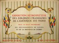
1929Best.-Nr. 265324Paris: Société de Géographie 1929. Jean Kerhor. Original poster. Color lithograph. 22 x 29.25 inches. Exhibition poster reading: "Retrospective exhibition of French Colonies in North America under the patronage of the Governments of Canada and the Province of Quebec". Text is located centrally within a cartouche and surrounded by three coats of arms to the top - those of New France Quebec and Canada - and a branch of three maple leaves at the bottom. Flags hang at either side along with weaponry and nautical equipment from the colonial period. At the base of the cartouche is an illustration of a ship at sea. Illustrated by Jean Kerhor. Dated April-June 1929. Issued by the Société de Géographie 10 Avenue d' Iéna. In good condition showing some wear and minor loss along original folds. Lined with archival paper. Société de Géographie unknown books
1518Best.-Nr. 461Venice: Aldus 1518. First Edition. Hardcover. Near fine. 1st and only Aldine edition in Latin from the press founded by Aldo Manuzio the most lionized scholar-printer of the Renaissance and the inventor of the portable pocket size book. This one is Mela's 43 AD Roman geography first printed the real 1st in Milan in 1471 and though our little book will quench your curiosity about comparing what was once thought to what is now known beyond that it has all the exhilaration of waiting for an elevator that barks at you in bells but whose doors never open. Later full vellum morocco labels vellum spotted small chip from the title page's corner and a short closed tear else near fine complete with b8 P • Victor. the addition on cosmology and the colophon. Not common in this condition but only in this condition. Aldus hardcover books
Best.-Nr. 60409 ½ inches 24 cm. diameter; 21 inches 53 cm. total height. Single pedestal globe with horizon ring armature & meridian all of wood wear and staining on meridian at point where fits into stand some chipping at extremities else fine; globe with vibrant original color and clear sharp patina; some abrasion & losses mostly in lower and upper extremities; overall very good plus condition. An attractive very capably executed table or desk globe in the distinctive style of the Delamarche firm "the most successful French entrepreneurs in maps and globes" Dekker/ van der Krogt. This was an original work by the son Felix who succeeded his father in the management of the firm in 1817. The globe is geographically up-to-date notably in the South Pacific and Alaska with information from then recent Russian voyages such as Krusenstern's. Related to this at the time the globe appeared and reflected on it Europeans were beginning to differentiate between various regions of the Pacific. These were based on a better understanding of cultural and other differences between the peoples of various areas encountered on these recent voyages. For example in 1831 the French explorer Dumont d'Urville proposed the use of the terms "Micronesia" and "Melanesia" for various parts of the Pacific as distinguished from Polynesia. Printed dashed lines on this globe labeled "Division Oceanique" roughly approximate the three eventually accepted divisions of what is referred to as the South Pacific though the regions are not named on the globe. Delamarche also clearly identifies on the globe the more traditional divisions of the Pacific between "Grand Ocean Boreal" "Grand Ocean Equinoxial" and "Grand Ocean Austral." The Delamarche firm was the first to successfully reach a fairly sizable general market of globe buyers. It accomplished this by reducing the cost of constructing globe stands and other parts while maintaining a high level of quality in the maps of their globes which are cleanly and attractively engraved. Traditional brass meridians were replaced by wooden ones and the horizon rings and armatures supporting the rings were greatly simplified and made from either wood or stiff board. Also the firm generally used simpler single-pedestal stands rather than four-legged designs. Yet as this well-preserved example demonstrates Delamarche's design and materials proved to be very durable. Charles-Francois Delamarche 1740-1817 the founder of the family firm was the successor of the great map and globe-making family the Robert De Vaugondys as is cited in the title of this globe. Delamarche in fact seemed to have cornered the globe market in France by also incorporating the stocks of Jean Fortin and Jean Lattre. Delamarche's son Felix took over the firm upon his father's death and managed it until 1848 when Gosselin succeeded him. The firm continued well into the latter 19th century under yet another Delamarche descendent. Dekker/ Van der Krogt Globes from the Western World pp. 63 74; Dekker E. Globes at Greenwich pp. 321-25; Suarez T. Early Mapping of the Pacific p. 25. books
1849Best.-Nr. 22568London: Simkin Marshall & Co 1849. 1st edition. Half-calf binding. Marbled boards. Abt VG occasional cracked hinge/head of spine panel missing/spine cracked held together by cords. xvi 17 - 465 pp. 8vo. 22cm x 14cm. Simkin, Marshall & Co hardcover books
1861Best.-Nr. 1012614to leather spine and corners with speckled boards maps colored in outline 23 pp. index. Top board almost separated joint split spine and edges are rather worn small piece missing at the top of spine preliminary page loose large folding map has split at the center; maps generally bright and clean. This atlas contains 22 maps that are colored in outline. Includes a nice map of Palestine and a folding map of some of the exploits of Alexander the Great. The atlas also contains an index that provides the latitude and longitude of the places named on the maps. H.G. Bohn, books
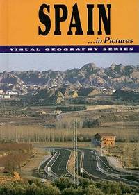
Best.-Nr. 0822518872-11-1Lerner Pub Group. Very Good. It's a well-cared-for item that has seen limited use. The item may show minor signs of wear. All the text is legible with all pages included. It may have slight markings and/or highlighting. Lerner Pub Group unknown
1735Best.-Nr. ABC_48059Amsterdam: Heirs of J. Ratelband & Comp. 1735. Contemporary calf gilt double ruling along the edges of both sides ribbed spine with title lettered in gold. Hand-written list of plates on the first fly-leaf listing only 38 of the 40 maps. Upright oblong 8vo 20 x 8.5 cm. With a woodcut ornament on the title-page 1 folding plate and 40 folding numbered engraved maps ca. 18 x 26.5-42 cm many of them surrounded with coat-of-arms city plans and views all coloured by hand of all parts of the world. The plate and maps are all folded 3 or even 4 times to the upright oblong format of the atlas. Rare complete second edition of this highly interesting pocket atlas intended for 18th-century travellers and military officers. The atlas opens with a finely engraved and contemporary hand-coloured folding plate illustrating military engineering fortification design ship types artillery weapons and the principal instruments of war in use during the first half of the 18th century. It is followed by a series of 40 engraved maps covering Europe Asia Africa and the Americas together with regional maps of the principal European kingdoms and provinces many enriched with town plans panoramic views coats of arms and other decorative features. Several maps bear bilingual French and Dutch titles.The first edition containing fewer maps was published by the same firm in 1732. A third edition followed in Amsterdam in 1747 published by B. van Gerrevink & the Heirs of J. Ratelband. Many of the maps are revised reissues of those engraved by Daniel de la Feuille for Les Tablettes Guerrières 1706 edited by Paul de la Feuille with later numbering added for their inclusion in the present atlas.This present work includes all maps listed in the publisher's contents comprising the complete sequence together with the 6 additional maps introduced for the second edition including Bosnia and Serbia the Rhine the Strait of Gibraltar the Gulf of Mexico and the Black Sea and Crimea while omitting the three plates removed from the first edition. The atlas therefore represents the complete published state of the second edition. The accompanying 16 pages of letterpress comprise the title a concise introduction to geography tables of the principal countries islands and rivers with their longitudes and latitudes and the printed index to the engraved plates and maps.Some tears in the folds of a few maps some repaired. Spine and binding edges a bit shaved.l Koeman III Rat. 1 1732 edition the present second edition is mentioned but not fully described; STCN 317870939 184225574 7 copies. Heirs of J. Ratelband & Comp., unknown
Best.-Nr. mon0000738437Chronicle Books 28/03/2017 00:00:01. hardcover. Like New. 2.6979 24.4814 18.6858. Chronicle Books hardcover
1937Best.-Nr. 030142New York: Alfred A. Knopf 1937. First American Edition 1st Printing. Hardcover. Near Fine/Very Good DJ. Maps Throughout. Xii 141 Iii Pp. Black Cloth Blue Lettering. A Good Summary Of European Colonial Politics And Geography Imposed By Military Action To 1937. Near Fine Slight Bumping At Top And Bottom Of Spine Some Browning To Endpapers Contents Clean No Names Or Marks. Dj With Light Wear Some Browning To Spine Small Losses At Top Corners Not Price-Clipped. Alfred A. Knopf hardcover
1889Best.-Nr. 029824London: Longmans Green And Co 1889. 2nd Edition . Hardcover. Good. 33 Color Maps Double Page 33 Pp Index At End. Brown Cloth Gilt Spine And Cover Yellow Endpapers. Wear At Edges A Little Fraying At Corners Hinges Cracked But Entirely Intact Binding Sound All Gilt Bright. Front Free Endpaper With Ownership Signature Of R A Demult May 13 1890; Stamp "Bennett's House" And Pasted In Seal Of Edward Vi On Beige Card. Longmans, Green, And Co hardcover
1938Best.-Nr. 029909Falmouth Massachusetts: Falmouth Publishing Company 1938. 1st Edition . Soft cover. Very Good. Map. Card Covers With Fold-Out Map Approximately 24" X 25" Fishing Guide On Inside Front Cover Distances To Other Locations O Rear Cover. Covers With Light Wear Name At Top Small Splach Mark Map In Excellent Condition. Falmouth Publishing Company paperback
1776Best.-Nr. 015982Circa 1776: Millar 1776. 1st Edition 1st Printing. Framed. Very Good/No Jacket. 15 1/2" x 14. Fine revolutionary era map of North America showing the British colonies with Nova Scotia part of the same British group of colonies as the Future United States with the southern colonies extending to the Ohio and Mississippi rivers. A clean complete copy with three folds as issued. Millar unknown
1709Best.-Nr. 021539Leiden Leide: Chez Pierre Vander Aa 1709. Derniere Edition . Full Leather. Very Good. 6 3/8" x 4. Folding Plates and Maps Throughout. Complete with two front endpapers illustrated title page no printed title page pp 1-140 with all plates maps folding maps. Original spine decorated in gilt five raised bands also decorated in gilt polished calf boards which appear to be replacements in the 17th or early 18th century. Watered colored endpapers. Contents clean and unworn binding worn and frayed but professionally refreshed and quite solid. Pencil signature of George Ellery Hale the astronomer. Chez Pierre Vander Aa hardcover
1931Best.-Nr. 021761Los Angeles: Regional Planning Commission County of Los Angeles 1931. First Edition . Hardcover. Fine. Color and B/W Plans Folding Plans and Maps. 206 Pp. First Edition 1931. Green Cloth Printed In Black Gilt Map. Fine Exhibition Quality. Regional Planning Commission, County of Los Angeles hardcover
1850Best.-Nr. 019528London and New York: The London Printing and Publishing Company - Limited 1850. First Edition Thus . Half Leather. Good. 11 1/8" Tall. 3 Colored Maps 22 Colored Plates 30 Uncolored Plates. Two Volumes Three Quarter Leather. Volume 1: 944 Pp With 30 Uncolored Plates And One Colored Map "Mexico California And Texas: The Newly Discovered Gold Districts". Volume Ii: 784 Pp With Two Colored Maps Of Canada And 22 Colored Plates All With Yellow Borders And Nice Original Color Throughout. The Map Of Mexico And California Tipped In But Neatly Loosened And Detached Without Intention And Usually Not Present Has Nicely Detailed Illustrations Of The Ruins At Uxmal Yucatan Mexican Peasantry And Gold Washing And Outlines The Gold Districts Of The U S And Mexico In Yellow. No Date Of Publication Indicated But Presumably 1850. Bindings Poor Three Of Four Boards Detached Spines Perished Boards Very Worn And Frayed Deserving Of An Expensive Rebind. Contents Near Fine Clean Maps Perfectly Preserved. Volume I With Additional Illustrated Title Page Showing Penn's Treaty Painted By Benjamin West And Here Engraved By J. Rogers. This Greatly Enlarged Fourth Edition With The Colored California Gold Map Is Uncommon About 7 Holdings Shown In Worldcat; It Is Not Listed In Carl Wheat's "The Maps Of The California Gold Region 1848 - 1857" Nor In The Addendum To The 1997 Martino Reprint Of That Book. The London Printing and Publishing Company - Limited hardcover