1997Best.-Nr. x-1857284631Ucl Pr Ltd 1997. Paperback. New. 1st edition. 202 pages. 9.50x6.25x0.50 inches. Ucl Pr Ltd paperback
1998Best.-Nr. x-0471977772John Wiley & Sons Inc 1998. Paperback. New. 2nd revised subsequent edition. 374 pages. 10.00x7.75x1.25 inches. John Wiley & Sons Inc paperback
2012Best.-Nr. DADAX144222116XRowman & Littlefield Publishers 2012-12-19. 1. hardcover. New. 5.69x0.63x8.82. Buy with confidence. Excellent Customer Service & Return policy. Rowman & Littlefield Publishers hardcover
Best.-Nr. Z1-M-011-02328Kessinger Publishing. Used - Like New. Used - Like New. This is a reproduction of an out of print title. This book may have occasional imperfections such as missing or blurred pages poor pictures errant marks etc. that were either part of the original artifact or were introduced by the scanning process. Ships from UK in 48 hours or less usually same day. Your purchase helps support Sri Lankan Children's Charity 'The Rainbow Centre'. 100% money back guarantee. We are a world class secondhand bookstore based in Hertfordshire United Kingdom and specialize in high quality textbooks across an enormous variety of subjects. We aim to provide a vast range of textbooks rare and collectible books at a great price. Our donations to The Rainbow Centre have helped provide an education and a safe haven to hundreds of children who live in appalling conditions. We provide a 100% money back guarantee and are dedicated to providing our customers with the highest standards of service in the bookselling industry. Kessinger Publishing unknown
1997Best.-Nr. x-0582246369Longman Pub Group 1997. Paperback. New. 232 pages. 9.50x6.50x0.50 inches. Longman Pub Group paperback
1526Best.-Nr. 137339Florence: Impressum per hæredes Philippi Iuntae 1526. Classical geography in the renaissance An early edition of this collection of classical geographical texts including Pomponius Mela and Julius Solinus and a translation into Latin of the Greek 1st-century world geography of Dinoysius Periegetes. The text is based on the first edition of the collection printed by the Aldine press in 1518. Octavo 149 x 96 mm. Eighteenth-century vellum spine lettered in gilt marbled sides. Vellum a little wormed rear hinge reinforced sporadic light foxing and a few instances of minor soiling faint dampstain at foot of ff. 17-24 and to top right corner of ff. 185-193 and 208 minor pencilled marginalia throughout cropped early annotations to ff. 51r 52r 68r and 204r and a few other early inked lines minor paper fault to f. 135v. A very good copy. hardcover
1958Best.-Nr. ZB915263Mexico D. F. 1958-1959. Price HAS BEEN REDUCED by 10% until Monday Nov. 2 weekend sale item volumes 85-89 an uninterrupted run of complete volumes paperbacks minor ownership markings else good. - If you are reading this this item is actually physically in our stock and ready for shipment once ordered. We are not bookjackers. Buyer is responsible for any additional duties taxes or fees required by recipient's country. Mexico, D. F. paperback
2008Best.-Nr. DADAX0742561003Rowman & Littlefield Publishers 2008-03-20. Edition Unstated. paperback. New. 6.05x0.62x9.03. Buy with confidence. Excellent Customer Service & Return policy. Rowman & Littlefield Publishers paperback
2010Best.-Nr. DADAX0739123459Lexington Books 2010-11-10. paperback. New. 6.07x1.10x9.34. Buy with confidence. Excellent Customer Service & Return policy. Lexington Books paperback
Best.-Nr. 33012Paris Amable Costes 1822. Relie demi-veau aux plattes exterieures marbrees carte depliante comme frontispice 100 x 170mm. 478pp. plusieures cartes depliantes a l'interieur. Ou l'on decrit la forme du gouvernement de chaque pays son climat ses productions etc. les moeurs de ses habitans et ce qu'il renferme de plus remarquable. Precede d'un abrege de la Geographie celeste physique et Mathematique. Avec un table des longitudes et latitudes des principales villes du monde et leur distance de Paris d'apres le bureau des longitudes. Paris Amable Costes 1822 unknown
1980Best.-Nr. ZB704982Mexico D F: Instituto Panamericano de Geografia e Historia 1980-1994. Price HAS BEEN REDUCED by 10% until Monday Nov. 2 weekend sale item Numbers 1-10 14-30 in 15 green buckram bindings with the original paper wrappers retained hardcovers ex library else text clean & bindings tight. - If you are reading this this item is actually physically in our stock and ready for shipment once ordered. We are not bookjackers. Buyer is responsible for any additional duties taxes or fees required by recipient's country. Photos available upon request. Mexico, D F: Instituto Panamericano de Geografia e Historia hardcover
1938Best.-Nr. ZB445459Mexico D.F.: Instituto Panamericano de Geografia e Historia 1938-1962. Price HAS BEEN REDUCED by 10% until Monday Nov. 2 weekend sale item volumes 1-54 an uninterrupted run of complete volumes bound ex library very good. - If you are reading this this item is actually physically in our stock and ready for shipment once ordered. We are not bookjackers. Buyer is responsible for any additional duties taxes or fees required by recipient's country. Photos available upon request. Mexico, D.F.: Instituto Panamericano de Geografia e Historia unknown
2009Best.-Nr. DADAX0578012995John A. Allen 2009-07-24. Second Edition. hardcover. New. 6.00x0.75x9.00. Buy with confidence. Excellent Customer Service & Return policy. John A. Allen hardcover
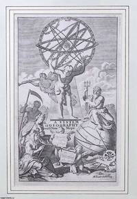
1701Best.-Nr. 373389Timothy Childe London 1701. Unframed Print. Very Good Condition. Allegorical figures surround an armillary sphere and globe symbolising Enlightenment inquiry and maritime exploration. This classical composition introduces Herman Molls comprehensive geographical atlas blending celestial science with imperial ambition in the visual language of early 18th-century cartography. This frontispiece serves as a visual manifesto for early Enlightenment geography. Its significance lies in how it captures an intellectual shift in how the world was imagined studied and claimed. Engraving 14 x 24 cms sheet 22 x 35 cms. Category: PRINTS : Antiquarian Interest; Antiquarian & Rare; Printed before 1800; Special Interest B. This item may require more postage than the rates shown for delivery outside the UK. If extra postage is required we will contact you before processing your order and you will be given the details and option to decline the extra cost. Timothy Childe unknown
2010Best.-Nr. DADAX1164943901Kessinger Publishing 2010-09-10. paperback. New. 6.00x0.91x9.00. Buy with confidence. Excellent Customer Service & Return policy. Kessinger Publishing paperback
1776Best.-Nr. 015982Circa 1776: Millar 1776. 1st Edition 1st Printing. Framed. Very Good/No Jacket. 15 1/2" x 14. Fine revolutionary era map of North America showing the British colonies with Nova Scotia part of the same British group of colonies as the Future United States with the southern colonies extending to the Ohio and Mississippi rivers. A clean complete copy with three folds as issued. Millar unknown
1709Best.-Nr. 021539Leiden Leide: Chez Pierre Vander Aa 1709. Derniere Edition . Full Leather. Very Good. 6 3/8" x 4. Folding Plates and Maps Throughout. Complete with two front endpapers illustrated title page no printed title page pp 1-140 with all plates maps folding maps. Original spine decorated in gilt five raised bands also decorated in gilt polished calf boards which appear to be replacements in the 17th or early 18th century. Watered colored endpapers. Contents clean and unworn binding worn and frayed but professionally refreshed and quite solid. Pencil signature of George Ellery Hale the astronomer. Chez Pierre Vander Aa hardcover
1931Best.-Nr. 021761Los Angeles: Regional Planning Commission County of Los Angeles 1931. First Edition . Hardcover. Fine. Color and B/W Plans Folding Plans and Maps. 206 Pp. First Edition 1931. Green Cloth Printed In Black Gilt Map. Fine Exhibition Quality. Regional Planning Commission, County of Los Angeles hardcover
1850Best.-Nr. 019528London and New York: The London Printing and Publishing Company - Limited 1850. First Edition Thus . Half Leather. Good. 11 1/8" Tall. 3 Colored Maps 22 Colored Plates 30 Uncolored Plates. Two Volumes Three Quarter Leather. Volume 1: 944 Pp With 30 Uncolored Plates And One Colored Map "Mexico California And Texas: The Newly Discovered Gold Districts". Volume Ii: 784 Pp With Two Colored Maps Of Canada And 22 Colored Plates All With Yellow Borders And Nice Original Color Throughout. The Map Of Mexico And California Tipped In But Neatly Loosened And Detached Without Intention And Usually Not Present Has Nicely Detailed Illustrations Of The Ruins At Uxmal Yucatan Mexican Peasantry And Gold Washing And Outlines The Gold Districts Of The U S And Mexico In Yellow. No Date Of Publication Indicated But Presumably 1850. Bindings Poor Three Of Four Boards Detached Spines Perished Boards Very Worn And Frayed Deserving Of An Expensive Rebind. Contents Near Fine Clean Maps Perfectly Preserved. Volume I With Additional Illustrated Title Page Showing Penn's Treaty Painted By Benjamin West And Here Engraved By J. Rogers. This Greatly Enlarged Fourth Edition With The Colored California Gold Map Is Uncommon About 7 Holdings Shown In Worldcat; It Is Not Listed In Carl Wheat's "The Maps Of The California Gold Region 1848 - 1857" Nor In The Addendum To The 1997 Martino Reprint Of That Book. The London Printing and Publishing Company - Limited hardcover
1939Best.-Nr. 018497Washington DC: United States Government Printing Office 1939. First Edition . Hardcover. Fine/No Dust Jacket. 11 3/4" Tall. Photographs Maps. Blue Cloth. First Edition. A Bright Clean Unworn Undamaged Example Spine And Cover Gilt Lettering Still Brilliant. Nicely Inscribed "To: Hon. Rudolph Forster / The White House / With Best Wishes From The Author H. Paul Caemmerer / Washington D. C. September 2 1941". Forster Was A Prominent Non-Political Presence In The White House Through Many Administrations. "Rudolph Forster Was Executive Clerk And Administrative Officer In Charge Of Executive Papers At The White House Until His Death In 1943. He Had Piled Up Nearly Fifty Years Of Service To Eight Presidents. His Job Was To Remind The President That A Bill For Example Must Be Acted Upon In A Certain Amount Of Time Or That By Law He Must Fill A Vacancy Within A Definite Period. He Was Also Responsible For The 'Orderly Handling Of Documents' And Supervision Of The Large Clerical Staff. He Was The Most Important Permanent Official At The White House. " -Off The Record With F.D.R. Rutgers University Press 1958. "Rudolph Is A Man Without Faults." - Franklin D. Roosevelt As Cited In That Book P. 140. United States Government Printing Office hardcover
1938Best.-Nr. 024555Bielefeld / Leipzig: Verlag Von Velhagen & Klasing 1938. Early Edition . Illustrated Wrappers. Very Good. 11 3/4" x 9 1/4. Color and B/W Maps. 48 Pp 32 Pp Tissue Overlay And Large Folding Maps Loose At Rear. Lightly Used Faint Red Stain In Small Area Across Front Cover. Loose Maps Show Incorporation Of Austria Etc. Verlag Von Velhagen & Klasing unknown
1861Best.-Nr. 005672Liverpool New York: Charles Magnus & Co. 1861. First Edition Thus . No Binding. Very Good . 28" x 24. Early Civil War Era Display Map Hand Colored Title "Union Military Map" At Top In Red White And Blue And Incorporating The 19" X 14.5" Complete Map Of The Rail Roads At Center Hand Colored With Other Three Maps Below Along With Hand Colored Figures Of Columbia And Justice And A Very Detailed Engraving Of The Capitol With The City Of Washington In The Background. Mounted On Board. The Map Of Rail Roads Has A Copyright Date Hand Corrected In The Printing Plate To 1859; The Map As A Whole Has A Copyright Date At Bottom Hand Corrected In The Plate To 1861. Another Version Probably Later Includes Additional Figures Of Uniformed Soldiers At Both Sides Of The Rail Road Map. In A Simple Yet Solid Black Frame With Uv-Resistant Glass. No Folds Or Tears. Scarce. Charles Magnus & Co. unknown
1945Best.-Nr. 006885Base Map Plant No. 1 GHO AFPAC / Melbourne Herald / RAAF 1945. First Edition . Illustrated Wrappers. Very Good. 12" x 16. Color Lithographic Designs; Maps. 161 pp. including glossary and comprehensive list of references. A manual intended to train newly assigned replacements to the unit 2821st Engineer Base Photomapping Company. Base Map Plant No. 1 GHO AFPAC / Melbourne Herald / RAAF unknown
2010Best.-Nr. SONG0739123459Lexington Books 2010-11-10. paperback. Used: Good. 6.07x1.10x9.34. Buy with confidence. Excellent Customer Service & Return policy. Lexington Books paperback
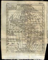
1751Best.-Nr. 69769Venezia 1751. 8vo. Samtidig helpergamentbind. 24 442 2 s. Med 19 foldede kobberstukne kart. Appresso Francesco Pitteri Italiensk. På Amerika-kartet er California gjengitt som øy ! Noen eselører materien noe brunplettet bindet med slitasjer i ryggen. unknown