12 491 résultats
1994Mm 215x300 Volume in copertina rigida con sovraccoperta editoriale, 126 pagine con numerose figure in nero e a colori nel testo. In appendice uno scritto di Pietro Profumi su "Dalla saggina alla scopa". Copia eccellente, spedizione in 24 ore dalla conferma dell'ordine.
2012David Nicolle Castelli in Terra Santa. , Osprey 2012, Buone condizioni: copertina rigida in buono stato, tagli sporchi, pagine pari a nuovo Buono (Good) . 72
1985réf. 5758448Springer-Verlag 1985. This is an ex-library book and may have the usual library/used-book markings inside.This book has hardback covers. In poor condition suitable as a reading copy. No dust jacket. Please note the Image in this listing is a stock photo and may not match the covers of the actual item2050grams ISBN:0387960120 Springer-Verlag hardcover
1880réf. 73021Hartford: O.D. Case and Company. Good. 1880. Hardback. Ex. Library Book Minor Cover Wear . O.D. Case and Company hardcover
1970Milano, 1970, stralcio con copertina posticcia muta, pp. 731/736 con fotografie e tavole fotografiche in nero e a colori. - !! ATTENZIONE !!: Con il termine estratto (o stralcio) intendiamo riferirci ad un fascicolo contenente un articolo di rivista, sia che esso sia stato stampato a parte utilizzando la stessa composizione sia che provenga direttamente da una rivista. Le pagine sono indicate come "da/a", ad esempio: 229/231 significa che il testo è composto da tre pagine. Quando la rivista di provenienza non viene indicata é perchè ci è sconosciuta. - !! ATTENTION !!: : NOT A BOOK : “estratto” or “stralcio” means simply a few pages, original nonetheless, printed in a magazine. Pages are indicated as in "from” “to", for example: 229/231 means the text comprises three pages (229, 230 and 231). If the magazine that contained the pages is not mentioned, it is because it is unknown to us.
1991réf. 7081603Pergamon Press/Open University 1991. This is an ex-library book and may have the usual library/used-book markings inside.This book has hardback covers. In fair condition suitable as a study copy. No dust jacket. Please note the Image in this listing is a stock photo and may not match the covers of the actual item1050grams ISBN:9780080363769 Pergamon Press/Open University hardcover
1972réf. 2298700McGraw-Hill 1972. This is an ex-library book and may have the usual library/used-book markings inside.This book has hardback covers. In good all round condition. No dust jacket. Please note the Image in this listing is a stock photo and may not match the covers of the actual item1150grams ISBN:007045132X McGraw-Hill hardcover
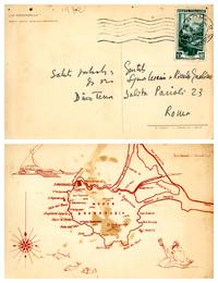
1952réf. 2401771952. Cartolina card. Molto buono Very Good. Cartolina postale autografa di Dino Terra inviata a Cesarina e Riccardo Gualino viaggiata con data del timbro postale 1952. Cm 105x16. . Molto buono Very Good. . La cartolina è affrancata con un ricercato francobollo della serie "Italia al lavoro" Il telaio Calabria di lire 10 del 1950 , unknown
19838°(cm.27,5), pp.243 (1), con numerose riprod. di antiche carte topogr. presenti alla mostra. Br. ed.
2006AA.VV. Cartografia geochimica ambientale e carte d'intervento per l'uso del territorio. , Ist. Poligrafico dello Stato 2006, Discreto stato. Due raccoglitori di carte in cofanetto in mezza tela. Carte in ottimo stato, ma esterno (cofanetto e raccoglitori) fortemente rovinati, da schiacciamento. Dalla collana 'Memorie descrittive della carta geologica d'Italia', volume LXIX. GEOLOGIA. Testo bilingue in Italiano e in inglese. Geologia AA VV Cartografia geochimica ambientale e carte d'intervento per l'uso del territorio Ist Poligrafico dello Stato 2006 Geologia Ottimo (Fine) . 9788824028523
1980réf. 82670Paris, Centre Georges Pompidou, 1980. Original Broschur, Gr.4°, 479 Seiten.
1780Edizione italiana di un caposaldo della cartografia di Joseph Nicolas De L’Isle, la mappa del Nord Pacifico. Il De L’Isle passò gran parte del suo tempo in Russia, fondando l’ Accademia delle Scienze a San Pietroburgo; il suo lavoro cartografico più importante fu l’ "Atlas Russicus", dettagliata rappresentazione della regione. Nel 1747 tornò a Parigi, con una importante mappa manoscritta sul Nord Pacifico che includeva informazioni sul Nord Asia ed America e sullo stretto che le separava. Le informazioni erano frutto delle spedizioni russe nello Stretto di Bering effettuate tra il 1723 e il 1741. Il De L’Isle realizzò una carta molto dettagliata che fu pubblicata nel 1750, della quale vennero realizzate diverse copie in tutta Europa, inclusa questa del Santini, pubblicata dalla tipografia Remondini. La versione italiana è molto simile all’originale e si differenzia sostanzialmente per il cartiglio barocco con dei costumi popolari di abitanti della Kamchatka e della Louisiana. Carta geografica curata da don Paolo Santini e dal fratello Francesco per il loro prestigioso Atlas universel dressé sur les meilleures cartes modernes, sontuoso atlante composto da mappe che rielaborano la più aggiornata cartografia francese in una veste veneta. Le carte sono prese dai migliori geografi del suo tempo, D’Anville, Bellin, Bonne, Borgomo, Boscovich, Clarici, Delisle, Jaillot, Janvier, Robert de Vaugondy. In effetti nelle carte dei Santini, vengono mescolati termini francesi con italiani, ma sono offerte con una grazia compositiva ed incisoria loro caratteristiche: una toponomastica non fitta, scritta in grande e ben leggibile. L’atlante di Santini non ebbe una grande fortuna editoriale e uscì in poche copie: venne quindi ristampato dai Remondini, che avevano acquistato dal Santini nel 1781 le incisioni in rame. Alle carte di Paolo Santini, datate fra il 1774 e il 1780, i Remondini aggiunsero diverse altre carte, datate fra il 1782 e il 1784: fra queste, nel secondo volume, la grande carte ripiegata dell’Italia, la Repubblica di Genova, la Palestina, le grandi carte dell’Africa. Paolo Santini (1729, Venezia–1793, Belluno), sacerdote cattolico presso la Chiesa di Santa Maria Formosa a Venezia, docente di disegno alle scuole della città lagunare della Provincia Veneta della Compagnia di Gesù. Santini, cartografo, incisore ed editore, aggiornò e pubblicò le mappe dei geografi e cartografi francesi Gilles Robert de Vaugondy (1688–1766) e Didier Robert de Vaugondy (c. 1723–1786), ispirandosi anche alle opere dei cartografi italiani, innanzitutto a quelle di Giovanni Antonio Rizzi Zannoni (1736–1814). Utilizzando, come modello, le mappe raccolte e pubblicate nel 1752 nell’Atlas Universel di Gilles Robert e Didier Robert de Vaugondy, acquistate a Parigi da suo fratello, Francesco Santini, e le «migliori carte geografiche» dell’epoca, Paolo Santini incise nuove lastre e diede alle stampe a Venezia, nel 1776, l’Atlas Universel dressé sur les meilleures cartes modernes. L’anno successivo, 1777, cedette i diritti di pubblicazione all’editore Giuseppe Remondini (1754–1811) di Bassano del Grappa che ristampò l’«Atlas Universel» in due volumi che raccoglievano complessivamente 123 carte geografiche. Le matrici in rame in possesso dei Santini furono poi acquistate, nel 178, dalla stamperia Remondini. Incisione in rame, coloritura coeva dei contorni, in ottimo stato di conservazione. Bibliografia NMM III, 277; Nordenskiöld 276; Phillips, Atlases 647. Rodolfo Gallo, L'incisione nel '700 a Venezia e a Bassano, in “Ateneo Veneto”, A. CXXXII, v. 128, pp. 153-214; Tooley, The Mapping of America 104. An Italian edition of Joseph Nicolas De L’Isle's important map of the north Pacific. De L’Isle spent many years working as a cartographer in Russia, founding the Academy of Sciences in St. Petersburg and producing the first Russian Atlas. In 1747, De L’Isle returned to France with a manuscript map of the north Pacific, including information on northeastern Asia, northwestern America and the strait between the two. He produced an engraved map, which was presented to the French Academy of Sciences in 1750. This map was very advanced in some areas, being based on Russian expeditions of 1723, 1732 and 1741, along with Vitus Bering's first and second voyages and the explorations of a number of others such as Tchirkow and Frondat. Unfortunately, the cartography of northwestern America is based on the fictitious account of Admiral de Fonte, showing a huge inland sea, the "Mer de L'Ouest," and waterways leading off towards Baffin's Bay-the long sought for Northwest Passage. Delisle's rendering became the standard for the region until Cook's explorations later in the century. Delisle's map was copied by many publishers, including the Italian Santini, whose map was later issued by Remondini. The Italian versions have a handsome rococo title cartouche balanced by text and images of a native of Kamchatka and one of Louisiana. Map compiled by Don Paolo Santini and his brother Francesco, for their prestigious Atlas universel dressé sur les meilleures cartes modernes, a sumptuous Atlas composed of maps that rework the most up-to-date French cartography in a Venetian guise. The maps are taken from the best geographers of his time, D'Anville, Bellin, Bonne, Borgomo, Boscovich, Clarici, Delisle, Jaillot, Janvier, Robert de Vaugondy. Indeed, in Santini's maps, French terms are mixed with Italian, but they are offered with a compositional and engraving grace that is characteristic of them: an uncluttered toponymy, written large and clearly legible. Santini's Atlas did not have great publishing success and came out in few copies: it was then reprinted by the Remondini, who had purchased the copperplates from Santini in 1781. To Paolo Santini's maps, dated between 1774 and 1780, the Remondini added several other maps, dated between 1782 and 1784: among them, in the second volume, the large folded maps of Italy, the Republic of Genoa, Palestine, and the large maps of Africa. Paolo Santini (1729, Venice-1793, Belluno), Catholic priest at the Church of Santa Maria Formosa in Venice, professor of drawing at schools in the Lagooon city of the Venetian Province of the Society of Jesus. Santini, a cartographer, engraver and publisher, updated and published the maps of French geographers and cartographers Gilles Robert de Vaugondy (1688-1766) and Didier Robert de Vaugondy (c. 1723-1786), also drawing inspiration from the works of Italian cartographers, first and foremost those of Giovanni Antonio Rizzi Zannoni (1736-1814). Using, as a model, the maps collected and published in 1752 in the Atlas Universel by Gilles Robert and Didier Robert de Vaugondy, purchased in Paris by his brother, Francesco Santini, and the "best maps" of the time, Paolo Santini engraved new plates and gave to the presses in Venice, in 1776, the Atlas Universel dressé sur les meilleures cartes modernes. The following year, 1777, he sold the publishing rights to publisher Giuseppe Remondini (1754-1811) of Bassano del Grappa, who reprinted the "Atlas Universel" in two volumes that collected a total of 123 maps. The copper plates in the Santini's possession were later purchased, in 1781, by the Remondini printing house. Copperplate engraving, original outline coloring, in excellent condition. Bibliografia NMM III, 277; Nordenskiöld 276; Phillips, Atlases 647. Rodolfo Gallo, L'incisione nel '700 a Venezia e a Bassano, in “Ateneo Veneto”, A. CXXXII, v. 128, pp. 153-214.
1844Carta geografica tratta dall’ Atlante geografico. Corredato di notizie relative alla geografia fisica politica, ed in generale alla statistica delle varie regioni del Globo. Compilato ed eseguito in litografia per cura e sotto la direzione di Benedetto Marzolla edito a Napoli nel 1858. Marzolla, autore di importanti atlanti sulle provincie del Regno di Napoli, è anche autore di diverse carte sulle Circoscrizioni Ecclesiastiche nel Regno delle Due Sicilie, pubblicate postume, nello stesso anno della morte (1858) a Napoli nello Stabilimento Geografico diretto da Luigi Manzella. Benedetto Marzolla fu disegnatore topografo e litografo; geografo e cartografo; membro della Commissione di statistica presso il Ministero dell'Interno. Personaggio di grandissimo rilievo nella cartografia napoletana ed italiana del XIX secolo, Marzolla ottenne in vita pubblici riconoscimenti ed attestati per la produzione cartografica di altissima qualità. La sua notorietà si è lentamente dissolta dopo la morte; va tuttavia osservato che solo la mancanza di uno spiccato coinvolgimento politico in senso risorgimentale e di una valenza letteraria nella sua opera non lo hanno reso famoso come i contemporanei Francesco Costantino Marmocchi (1805-1858) e Attilio Zuccagni-Orlandini (1783-1872), con i quali può certamente confrontarsi. I progetti culturali didattici e editoriali di Marzolla furono e rimangono di straordinaria modernità; egli inventò, è il caso di dire, un nuovo modo di intendere e di disegnare la carta geografica, fornendo una visione assolutamente originale della comunicazione dei dati geografici attraverso la combinazione di testo e immagine. Con tale operazione, egli riuscì a fondere in un'unica opera, storia, geografia, economia, statistica e cartografia, raggiungendo un equilibrio grafico di rara efficacia (cfr. V. Valerio, Benedetto Marzolla Brindisino, Geografo e Cartografo dell'800 Europeo, Brindisi 2008). Bell’esemplare con coloritura coeva dei contorni, in ottimo stato di conservazione. Bibliografia V. Valerio, Benedetto Marzolla Brindisino, Geografo e Cartografo dell’800 Europeo (2008), n. 74. Benedetto Marzolla is famous for being among the most important cartographers of the XIX century, for being the one to print geographic maps using high quality lithographies. His Atlante Geografico, made of 58 maps, presents finely sketched works. Six maps depict North America, among them famous map of gold diggers in California, deriving from Hippolite Ferry. Extremely relevant are also the maps of Antarctic, South Africa with the plan of Cape Town and those about Australia. Though the maps are dated between 1843 and 1856, this 1858 edition, printed in Naples at the Stabilimento Geografico Strada San Carlo (founded by Marzolla himself), represents the final version of his atlas, the last one before his death. A posthumous edition will be published in 1865. Map taken from the Atlante geografico. Corredato di notizie relative alla geografia fisica politica, ed in generale alla statistica delle varie regioni del Globo. Compilato ed eseguito in litografia per cura e sotto la direzione di Benedetto Marzolla published in Naples in 1858. Marzolla, author of important atlases on the provinces of the Kingdom of Naples, is also the author of several maps on the Ecclesiastical Circumscriptions in the Kingdom of the Two Sicilies, published posthumously in the same year of his death (1858) in Naples in the Stabilimento Geografico directed by Luigi Manzella. Benedetto Marzolla was draftsman topographer and lithographer, geographer and cartographer. Character of great importance in the Neapolitan and Italian cartography of the nineteenth century, Marzolla obtained during his life public recognition and certificates for the production of high quality cartography. His notoriety slowly faded after his death; it should be noted, however, that only the lack of a strong political involvement in the sense of the Risorgimento and of a literary value in his work did not make him as famous as his contemporaries Francesco Costantino Marmocchi (1805-1858) and Attilio Zuccagni-Orlandini (1783-1872), with whom he can certainly compare himself. Marzolla's cultural, didactic and editorial projects were, and remain, extraordinarily modern; he invented a new way of understanding and drawing maps, providing an absolutely original vision of the communication of geographical data through the combination of text and image. With this operation, he was able to merge in a single work, history, geography, economics, statistics and cartography, achieving a graphic balance of rare effectiveness. Beautiful specimen with contemporary coloring of the contours, in excellent condition. The atlas is pretty rare, is not actually listed in Phillips, British Library e OCLC. Bibliografia Valerio, Benedetto Marzolla. Brindisino, Geografo e Cartografo dell’800 Europeo, p. 57, 3F. Tooley,s Dictionary, p. 216.
1853Interessante carta geografica delle Terre Artiche del Conte Maniscalchi Erizzo che fissa le scoperte fino al 1853. Il titol si trova iscritto in campo libero lungo il margine destro, mentre nell'angolo in alto a sinistra sono riportate le Osservazioni e legenda. Si legge "I legni in cerca di Sir John Franklin sotto il comando del Cap.o Austin della M.a Reale, Cap.o Penny e Sir J. C. Ross svernarono sulla costa meridionale della terra Cornvallis nel 1850 e nella primavera del 1851 esplorarono sui ghiaccj" sono poi elencati gli ufficiali sotto il comando del Cpitano Austin, Penny con l'indcazione delle miglia percorse. Applicata su tela. Pieghe editoriali. Ottimo stato di conservazione
1860Carta geografica della Terra Santa, con l'indicazione delle tribù. Pianta dell'antica Gerusalemme, in piccolo riquadro nell'angolo a dx., in basso
2007ill., ril. Dopo l'uscita nel 2007 della prima edizione di questo volume, da tempo andata esaurita, gli stessi autori ne presentano una nuova edizione, notevolmente ampliata grazie ai documenti e alle informazioni raccolti negli ultimi anni. Il lavoro descrive il carro leggero L6, i semoventi L40, i prototipi e derivati a essi legati; fa parte della collana dedicata dal GMT ai mezzi corazzati italiani, che conta già numerosi titoli. Gli aspetti tecnici e storici vengono presentati capitolo dopo capitolo, con l'aiuto di schede, organici, disegni e molte immagini. Come in passato, non mancano i riferimenti agli equipaggi, alle loro uniformi, alle dotazioni dei reparti, ai ricordi dei protagonisti. Numerose tavole a colori realizzate da Ruggero Calò completano questo lavoro, al quale hanno contribuito ricercatori italiani e stranieri.
2004ill., ril.
réf. 9786555201376ALTA CULT. new. A pandemia alterou para sempre o mundo corporativo desafiando ainda mais quem busca ser protagonista da pr��pria jornada. De forma prǭtica Carreiras Exponenciais chega como um poderoso guia para ajudar a repensar mapear e planejar cada passo do seu caminho profissional. Este livro apresenta uma nova forma de enxergar e desenvolver habilidades fundamentais para quem busca ascens�o em um mundo cada vez mais plural e menos linear. Em qualquer ramo que decida atuar viver exponencialmente na Era Digital demandarǭ um novo conjunto de compet�ncias reveladas pelo autor ao longo de seis dimens��es que se unem em torno do bem mais precioso para qualquer ser humano: sua trajet��ria de vida. Eberson Terra Ǹ executivo da ǭrea da Educa��o liderou times de mais de 2 mil pessoas e conquistou pr�mios nacionais como o da Equipe Campe� do Reclame Aqui em 2016. Ap��s um per�odo sabǭtico decidiu se tornar consultor de neg��cios e transi��o de carreira. � um dos Top Voices do LinkedIn mais lidos no Brasil e seu conte�do foca o cotidiano do mundo corporativo lideran��a inova��o e empreendedorismo. ALTA CULT unknown
197179 pages. Circa 1971. Includes the following classic songs: I Feel the Earth Move; So Far Away; It's Too Late; Home Again; Beautiful; Way Over Yonder; You've Got a Friend; Where You Lead; Will You Still Love Me Tomorrow; Smackwater Jack; Tapestry; (you make me feel like) A Natural Woman. Average wear. Unmarked. Binding intact. One of the best songbooks of all time. Book
1975réf. 153407Ein Buch für Menschen ab 8 mit einem "Gucki" und vielen Dias zum Betrachten. Osnabrück, terre des hommes, ca. 1975. Mit 1 Foto, 24 Dias u. einem Diabetrachter. 24 S. Or.-Kart. mit Spiralheftung; leichte Schabspuren.
1996réf. Q-0309053919National Academies Press 1996-03-12. Paperback. New. In shrink wrap. Looks like an interesting title! National Academies Press paperback
1998réf. 9634702Manson Publishing 1998. This is an ex-library book and may have the usual library/used-book markings inside.This book has soft covers. In good all round condition. Please note the Image in this listing is a stock photo and may not match the covers of the actual item650grams ISBN:1874545847 Manson Publishing paperback
1997réf. 5585330Society Of Exploration Geophysicists Seg 1997. Volume 6. This is an ex-library book and may have the usual library/used-book markings inside.This book has hardback covers. In good all round condition. Please note the Image in this listing is a stock photo and may not match the covers of the actual item1850grams ISBN:1560800380 Society Of Exploration Geophysicists (Seg) hardcover
1985réf. GE-258New York: Springer-Verlag 1985. Classic comprehensive text presents an outstanding compilation of research on the geology of carbonate oil and gas reservoirs including thirty-five case studies involving 41 reservoirs from a broad range of depositional settings tectonic provinces and burial/diagenetic histories. Includes coverage of sedimentological and diagenetic controls; petrophysics; production performance; reservoir summary of each case study; etc. 622 pgs. 386 Illustrations. Inscribed/signed by Choquette on the half-title pg. Prior owner's name blacked out on front endpaper. Minimal shelfwear. Signed by Author. First Edition. Hard Cover. Fine. 4to - over 9¾" - 12" tall. Springer-Verlag Hardcover