Bacchi Andrea; Riebesell ChristinaMareMagnum

12.011 risultati
2011Firenze, 2011; ril., pp. 46, tavv. col., cm 22,5x30,5. italiano ril.
2002Menaggio, 2002; cartonato, pp. 112, ill. b/n e col., cm 23,5x34.
1856rif. 218181856 Paris, Hachette (Bibliothèque des Chemins de Fer), 1856, in 12 broché, 427 pages ; couverture illustrée.
1856rif. 734741856 Paris, Hachette (Bibliothèque des Chemins de Fer), 1856, in 12 relié demi-basane vert bouteille, dos lisse orné, 427 pages ; cachets ; frottis d'usage ; intérieur frais.
1966Firenze, 1966, 8vo stralcio con copertina posticcia muta, pp. 379/396 con 2 tavole fotografiche. - !! ATTENZIONE !!: Con il termine estratto (o stralcio) intendiamo riferirci ad un fascicolo contenente un articolo, completo in se, sia che esso sia stato stampato a parte utilizzando la stessa composizione sia che provenga direttamente da una rivista. Le pagine sono indicate come "da/a", ad esempio: 229/231 significa che il testo è composto da tre pagine. Quando la rivista di provenienza non viene indicata é perché ci è sconosciuta. - !! ATTENTION !!: : NOT A BOOK : “extract” or “excerpt” means simply a few pages, original nonetheless, printed in a magazine. Pages are indicated as in "from” “to", for example: 229/231 means the text comprises three pages (229, 230 and 231). If the magazine that contained the pages is not mentioned, it is because it is unknown to us.
rif. CF459bisPlaquette in-8 carrée, 14 pages, photos Roger Schall, couverture cartonnée.
1987Feltre, 1987; br., pp. 181, ill. b/n e col., tavv. b/n. italiano
1910rif. ZB626499London 1910. Price HAS BEEN REDUCED by 10% until Monday Oct. 26 weekend SALE item volumes 2 23-24 26-27 1910-1938; complete volumes octavos publisher's original cloth ex library overall good-very good PRICE IS FOR THE LOT. - If you are reading this this item is actually physically in our stock and ready for shipment once ordered. We are not bookjackers. Buyer is responsible for any additional duties taxes or fees required by recipient's country. London hardcover
rif. CF444Album 22x32 cm, planches sur double-page avec plan et profil du N° 3 au N° 58. Il manque la dem-carte gauche et les planches 1 et 2.
rif. CF123Carnet 14x36cm., 1 carte sur double page, notice, 72 pp. de croquis, cartonnage.
rif. 6147Genève, éditions Zoé, 2017. In-8 broché, couverture à rabats. A l'état de neuf.
1916In 4? (cm 30), Brossura moderna in carta Varese, pagg.4 Stralcio da pag. 91 a pag. 94 con 1 ill. b.n. n.t relativa agli strumenti di ferro nella cava di marmo "Fantiscritti" in frazione Miseglia, ben conservato. Il Galli, archeologo, nacque a a Majera nel 1880.
1916In 4? (cm 30), Brossura moderna in carta Varese, pagg.4 Stralcio da pag. 91 a pag. 94 con 1 ill. b.n. n.t relativa agli strumenti di ferro nella cava di marmo "Fantiscritti" in frazione Miseglia, ben conservato. Il Galli, archeologo, nacque a a Majera (Maier?) nel 1880.
rif. 14555Carte générale de l’Italie indiquant les routes et les Chemins de fer par BERTHE L. géographe. Garnier Frères libraires éditeurs sans date. Couverture imprimée avec vignette 120x200mm, carte dépliée 620x290mm.
1998rif. R240108532AUTOROUTES DU SUD DE LA FRANCE. 1998. In-8. Broché. Bon état, Couv. convenable, Dos satisfaisant, Intérieur frais. carte routière en couleur, recto-verso - environ 60 x 80 cm. . . . Classification Dewey : 625-Chemins de fer, routes, autoroutes
1965rif. 1041641965 Annales Littéraire de l'Université de Besançon. Vol. 73 (Archéologie 18). "Les Belles Lettres", 1965 - Ouvrage imprimé avec le concours du Centre National de la Recherche Scientifique et de l'Académie nationale de Metz - In-8 broché, sous jaquette illustrée - 170 pages + 27 planches - 2 tableaux dépliants dans l'ouvrage
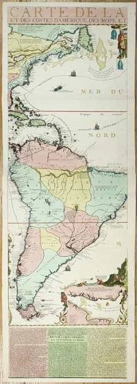
rif. 11134Paris: 1713. No binding. Very Good. 1175 x 380 mm. full early wash colour with accompanying title page included a key map bookplate of the Duke of York on the verso in very good condition. Three sheets of an exceedingly rare fifteen-sheet wall map by Nicolas de Fer accompanied by the title with key map all in fabulous original colour. When published in 1713 it was the most extravagant map of America yet produced. It encompasses not just the American continent but the whole of the Pacific Ocean also. The map is made up of ten sheets in two rows of five and accompanied by 5 further smaller sheets of descriptive text which are not always present along the bottom. Here we offer the two sheets encompassing the east coast of North America and much of South America. The end of the War of Spanish Succession 1701-14 was near by 1711 and with a weakened Spain France began to eye North America. This renewed interest led to 'Louisiana' and the founding of New Orleans in 1718. Nicholas de Fer 1646-1720 was born the youngest of eight children to the map seller Antoine de Fer fl.1644-d.1673 and grew to be one of the most well-known mapmakers in France in the seventeenth century. He was apprenticed in 1659 to the engraver Louis Spirinx at the age of twelve. Following the death of his father in 1673 Nicholas worked with his mother to continue the family business. On her retirement in 1687 she passed the business to Nicolas in exchange for a crown a week unlimited bread and a pint of wine per day Pastoureau. His earliest known work is a map of the Canal of Languedoc in 1669. Arguably his most famous production is his wall map of America published in 1698. It is renowned for the beaver scene. In 1690 he became cartographer to the Dauphin of France and eventually to Louis XIV himself. From 1690 he began publishing his own books such as 'Les Forces de l'Europe' and the 'Petit et Nouveau Atlas' in 1697. His first wall map in 1694 was naturally of the world and this was followed by a set of four continents. The British possessions are hemmed into the coast of North America and include Acadia. In South America the mythical Lake Parime is excluded but the Orinoco and Amazon Rivers are still connected. Sea routes to and from the tip of South America are displayed and a fabulous inset of the Rio de la Plata is found lower right. The scene accompanying this is the mountain of Potosi the source of fabulous silver reserves with an image of panning for gold in the water nearby. The whole is wonderfully engraved by P. Starckman and dedicated to Monseigneur le Comte de Toulouse. The text beneath describes the voyage of Jacques le Hermite 1582-1624 in 1623-5 to present day Argentina and Tierra del Fuego. Le Hermite himself died on the voyage in Callao on the Peruvian coast. The map was a model for the later reduction by Henri Abraham Chatelain published in 1719 and Hermann Moll. An extremely rare map no examples are traced in the Library of Congress or the British Library. This example is from the magnificent collection of the Duke of York 1763-1827 unfortunately distributed at Sotheby's in May 1827. The second son of King George III he early on entered the military. His unfortune experiences can often be laid at the poor state of the military forces. It however led to the mocking rhyme 'The Grand Old Duke of York'. He is now credited with reshaping the armed forces to be more professional and merit based. He became Commander-in-Chief during the Napoleonic Wars. His collection when auctioned was described as being '88 folio double book cases' which contained 5500 maps each of which bore his distinctive bookplate with manuscript volume and map number below. Provenance: With bookplate of Frederick Augustus Duke of York 1763-1827; Sotheby's May 1827; collection of Hein Wenzel Berlin with stamp; Richard B. Arkway Inc. 2000; Juan and Peggy Rada Collection. Harley & Walters 1978; Howgego 2003 1713 unknown
rif. 2n1615ca. 1692. Blattgröße: 365 cm x 275 cm. - kräftiger Abdruck / sauberes Blatt - unknown
rif. 2n1775De Fer Paris 1705. Maße: 285 cm x 195 cm kleiner Einriß am oberen Blattrand. - Nicolas de Fer war einer der führenden französischen Kartographen und Kartenverleger - unknown
rif. 1841aaum 1700. Maße: ca. 327 x 25 cm mehrfach gefaltet gering fleckig/Blatt mit kleinen Randläsuren. unknown
rif. 104521aafA Paris chez le Sr. de Fer dans l’Isle du Palais sur le Quay de l’Horloge à la Sphère Royale Avec privilege du Roi, 1705, 23x33 cm, carte gravée sur cuivre, 1 feuille / 1 Blatt (27x41 cm),
rif. ARR00536Ministère des Travaux Publics, 1883. Carte entoilée 100x80 cm, échelle 1/ 1. 250 000e, environs de Paris repris au 1/500 000e.
rif. 13841Paris : Napoléon Chaix (Guide-Chaix - Carte des chemins de fer français), 1854 - carte lithographiée en couleurs (jaune, bleu, rose, vert et noir), dépliante entoilée sous étui gaufré pleine percaline, doré de l'éditeur (63,5 x 90,5 cm, toile comprise) - carte d'une grande fraîcheur en très bon état -
rif. RO20144501LIBRAIRIE CHAIX. fin XIXème. In-Plano. Broché. Bon état, Couv. convenable, Dos satisfaisant, Intérieur frais. Carte en noir et blanc, d'environ 119 x 90 cm. Echelle 1 / 1.200 000.. . . . Classification Dewey : 625-Chemins de fer, routes, autoroutes