12.061 risultati
1934rif. E41518Tours, Arrault 1934 500pp., br.orig., cachet, bon état, ["Les documents de la Chambre de Commerce Internationale"], E41518
1948rif. RO80085846CHEZ L'AUTEUR. 1948. In-4. Broché. Bon état, Couv. convenable, Dos satisfaisant, Intérieur frais. 25 pages de texte dactylographié.. . . . Classification Dewey : 625-Chemins de fer, routes, autoroutes
rif. RO80117549P.L.M.. Non daté. In-8. Broché. Bon état, Couv. convenable, Dos satisfaisant, Intérieur frais. Une brochure dépliante en 6 volets, composée d'une carte en couleurs et de quelques photos en noir et blanc, au dos.. . . . Classification Dewey : 912-Atlas, cartes et plans
1915rif. 24661Besançon Jacques & Demontrond 1915 In-12 157 pp, belle impression en bistre , reproductions photographiques, itinéraires des chemins de fer . deux petits trous en couverture n'affectant pas l'illustration
PARIS? E. Baudelot & cie - Sans date 1920 (?) - In-4 - Broché - couverture illustrée - Carte & nombreuses illustrations NB - Publicités locales
rif. 6024PARIS? E. Baudelot & cie - Sans date 1920 (?) - In-4 - Broché - couverture illustrée - Carte & nombreuses illustrations NB - Publicités locales
1930rif. RO80130531HACHETTE. 1930. In-8. Broché. Très bon état, Couv. fraîche, Dos satisfaisant, Intérieur frais. 48 pages. Frontispice en noir et blanc. Nombreuses photos et cartes en noir et blanc, dans le texte et hors-texte.. . . . Classification Dewey : 625-Chemins de fer, routes, autoroutes
1929rif. RO80042984HACHETTE. 1929. In-8. Broché. Bon état, Couv. défraîchie, Dos satisfaisant, Intérieur frais. 48 pages. Frontispice en noir et blanc. Nombreuses photos et cartes en noir et blanc, hors-texte et dans le texte.. . . . Classification Dewey : 625-Chemins de fer, routes, autoroutes
rif. 20833Chemin de fer PLM ,carte dépliante sous couverture illustrée,vers 1910,IN4 etroit,couverture cartonnée souple,illustrée, à l'intérieur dépliant "accordéon" avec au recto la carte couleur des Alpes et au verso, description des 5 étapes routières. bel exemplaire
ISBN : 2842302168. HOEBEKE. 2004. In-4 Carré. Relié, Jaquette. Bon état. Couv. convenable. Dos satisfaisant. Intérieur frais. 165 pages. Nombreuses illustrations en couleurs et noir et blanc dans et hors texte.
2004rif. R110176011HOEBEKE. 2004. In-4. Relié. Bon état, Couv. convenable, Dos satisfaisant, Intérieur frais. 165 pages. Nombreuses illustrations en couleurs et noir et blanc dans et hors texte.. Avec Jaquette. . . Classification Dewey : 625-Chemins de fer, routes, autoroutes
1975rif. RO30140716OFFICE DE DISTRIBUTION DE MATERIEL PEDAGOGIQUE. VERS 1975. In-8. Broché. Etat d'usage, Couv. convenable, Agraffes rouillées, Intérieur frais. 47 pages augmentées de nombreuses photos et illustrations en noir et blanc dans et hors texte - 2 PHOTOS DISPONIBLES. . . . Classification Dewey : 625-Chemins de fer, routes, autoroutes
1967rif. RO20000701Time-Life. 1967. In-4. Cartonnage d'éditeurs. Bon état, Couv. convenable, Dos satisfaisant, Intérieur frais. 200 pp., photographies couleurs. . . . Classification Dewey : 625-Chemins de fer, routes, autoroutes
1957rif. AUB-6747Saint-Aubin, éd. de la Béroche 1957. Bel exemplaire broché, non coupé, plats ornés, non coupé, gd in-8, 256 pages + planches. Exemplaire de luxe numéroté sur libris I jaunâtre.
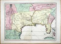
rif. 9768Paris: A Paris dans l'!sle sur Ie Quay de l'Orloge a la Sphere Royale avec Prive. Du Roy 1715. 1715. No binding. Good. EXTREMELY RARE FIRST STATE OF NICOLAS DE FER'S LANDMARK MAP IN FULL CONTEMPORARY WASH COLOUR. 465 x 640 mm. in full early wash colour faint water stain lower centrefold otherwise in excellent condition. EXTREMELY RARE FIRST STATE OF NICOLAS DE FER'S LANDMARK MAP IN FULL CONTEMPORARY WASH COLOUR. This printed map is derived from the manuscript of Guillaume de L'Isle in 1701 a significant map in the history of the depiction of the Mississippi Valley. Considerable advances were made in the understanding of this region particularly along the Gulf of Mexico in the first two decades of the 1700s. Much of this new information came at the hands of French explorers. In Paris the key mapmakers processing this information were Claude de L'Isle 1644-1720 his son Guillaume de L'Isle 1675-1726 and Nicolas de Fer 1646-1720. The three significant printed maps of the time are De L'Isle's Carte du Mexique et de la Floride 1703 La Riviere de Missisipi et ses Environs 1718 and this de Fer 1715. The de Fer is an important link in the understanding of the region. The most prominent unknown at the beginning of this period was the location of the mouth of the Mississippi River. Whilst René-Robert Cavalier de La Salle 1643-87 had proved that the Mississippi River flowed into the Gulf of Mexico the position of its mouth was ill conceived and displayed too far west on contemporary maps. 'During the 1690s attempts had been made to encourage an expedition to follow on La Salle's claims to the Mississippi valley. All of them foundered until a government-sponsored one by Louis Phélypeux Comte de Pontchartrain Minister of the Navy. He ordered Pierre le Moyne d'Iberville to command the voyage. He was the third of fourteen children of Charles Le Moyne 1626-83 who had arrived in Canada in 1641. Pierre 1661-1706 was born at Ville-Marie Canada and by the age of fourteen had sailed to France returning in 1678. In 1686 he was present with some of his brothers fighting the English in Hudson Bay under Pierre de Troyes. On another voyage to the same region he was trapped in the ice along with the English and there spent the winter of 1689-90 until freed in the spring. Most of his experience was in Canada although he did take part in an attack on Schenectady in New York 1690. Pontchartrain's instructions to d'Iberville were to establish a colony at the mouth of the Mississippi River and therefore enable control of the huge waterway. He sailed from Brest on 24 October 1698 with three vessels and 200 colonists arriving at Ship Island off present day Biloxi Mississippi 25 January 1699. Having put ashore the colonists he embarked in four small boats up the Mississippi delta until he reached the Iberville River which he entered. Crossing Lakes Maurepas and Pontchartrain he returned to the coast. He then began construction of Fort Maurepas on Biloxi Bay before leaving for France on 4 May 1699' Burden. 'D'Iberville returned to Biloxi promptly arriving 7 December 1699. In the New Year he constructed Fort Iberville eighteen leagues upriver from the mouth of the Mississippi … The most detailed record cartographically of d'Iberville's voyages can be found in Nicolas de Fer's Les Costes aux Environs de la Riviere de Misisipi 1701' Burden. The results of these explorations were recorded on Guillaume De L'Isle's 1701 manuscript. It was one of the first to display the Mississippi delta and to illustrate the extent of the Missouri River. Cumming described it as 'notable for its early representation of the Carolina Trading Path' from Charleston Carolina to the Mississippi river. De L'Isle never published a printed version of the manuscript. The second state of Claude and Guillaume De L'Isle's L'Amerique Septentrionale in 1700 records a delta but is not directly derived from the manuscript. The only printed version was this map issued by De Fer in 1715 with additional information. Jackson notes 'the s A Paris dans l'!sle sur Ie Quay de l'Orloge a la Sphere Royale avec Prive. Du Roy 1715. 1715 unknown
2009rif. LFA00a08Un ouvrage de 80 pages, format 190 x 225 mm, illustré, broché couverture couleurs, publié en 2009, Editions Sud Ouest, bon état
2018rif. R260252550Au bureau du journal. 2018. In-8. Broché. Bon état, Couv. convenable, Dos satisfaisant, Intérieur frais. 210 pages augmentées de quelques graphiques en noir et blanc dans texte.. . . . Classification Dewey : 625-Chemins de fer, routes, autoroutes
1905rif. 960511905 La Revue d'Europe et des Colonies. 1905. 1 vol in-8. demi basane marron foncé. 432 pages. Quelques illustrations en noir et blanc. Une grande carte dépliante des colonies françaises en Allemagne
1977rif. R150219575FLAMMARION. 1977. In-12. Broché. Bon état, Couv. convenable, Dos satisfaisant, Intérieur frais. 186 pages. . . . Classification Dewey : 947-Europe de l'Est, URSS
rif. 19185Format d'un livre de poche.186 pages. Quelques petites rousseurs. Une expédition par Mondial Relay vous sera proposée 1977 Champs Flammarion
1972rif. R240130182EDITIONS DU BURIN / EDITIONS MARTINSART. 1972. In-4. Relié. Bon état, Couv. convenable, Dos satisfaisant, Intérieur frais. 297 pages - nombreuses illustrations en couleurs dans et hors texte.. . . . Classification Dewey : 940.3-Première Guerre mondiale 1914-1918
1972rif. R160137622DU BURIN. 12 OCT 1972. In-8. Cartonnage d'éditeurs. Bon état, Couv. convenable, Dos satisfaisant, Intérieur frais. 298 pages. Nombreuses illustrations originales en couleurs, dans le texte et hors texte de P. EVERENKO. Ouvrage de bibliothèque avec une couverture plastique transparente sur la couverture originale.Tampons de bibliothèque sur la page de titre. Une étiquette de code en pied du dos.. . . . Classification Dewey : 840-Littératures des langues romanes. Littérature française
Gr. In-8, 177p. Thèse de doctorat présentée à l'Université de Lausanne.