|
AMMEN (Daniel).
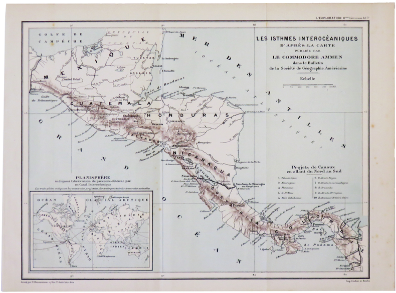
[AMÉRIQUE CENTRALE] Les isthmes interocéaniques d'après la carte publiée par le Commodore Ammen.
[1877]. 213 x 286 mm.
Bookseller reference : LBW-5016
|
|
|
Amy Singer Amy Singer Editor historic ottoman prints and maps Illustrator
Starting with Food: Culinary Approaches to Ottoman History
Markus Wiener Publishing Inc 2011-01-15. Paperback. Used:Good. Markus Wiener Publishing Inc paperback
Bookseller reference : DADAX155876514X ISBN : 155876514X 9781558765146
|
|
|
Amy Singer; Illustrator historic ottoman prints and maps
Starting with Food: Culinary Approaches to Ottoman History
Markus Wiener Publishing Inc 2011-01-15. Paperback. Good. Markus Wiener Publishing Inc paperback
Bookseller reference : SONG155876514X ISBN : 155876514X 9781558765146
|
|
|
Anderson Brian and Eileen Anderson photographs by the authors maps and plans by Robert Smith
ALGARVE AND SOUTHERN PORTUGAL PASSPORT'S REGIONAL GUIDES OF PORTUGAL
Lincolnwood: Passport Books / NTC Publishing Group 1996. Very Good. 1996. First Edition. Trade Paperback. 0844245453 . Presumed first edition no statement of printing. 199 pages illustrated index. VG copy with some bumping to a portion of the rear spine edge. . Passport Books / NTC Publishing Group [1996] paperback
Bookseller reference : 28681 ISBN : 0844245453 9780844245454

|
|
|
ANDERSON LORRAINE & ABBY PHILLIPS METZGER WITH MAPS BY MONICA DROST
Wild In The Willamette: Exploring The Mid-valley's Parks Trails And Natural Areas
Oregon State University Press Corvallis: 2015. Softcover. Brand new book. Located between the population centers of Portland and Eugene Oregon's Willamette Valley boasts rich opportunities for outdoor recreation that are too often overlooked. Wild in the Willamette is a guidebook to the natural treasures of the mid-Willamette Valley extending far beyond the familiar I-5 corridor. Sprinkled with natural history sidebars and infused with essays by notable local authors it aims to connect residents and visitors with the best hiking biking and paddling opportunities the mid-Valley offers. With a special focus on seven watersheds�the Marys Calapooia South Santiam North Santiam Luckiamute Yamhill and Pudding�as well as the middle portion of the main stem Willamette River the book describes a range of outings at different levels of challenge. Families with young children day hikers long-distance backpackers kayakers canoeists bird watchers and cyclists alike will find ideas for spending a satisfying afternoon or venturing outside for a multiday trip. Whether choosing a wheelchair-accessible trail a rugged hike in a wilderness area a dip in a rocky swimming hole a paddle on the broad Willamette or a bike ride through farmland�whether lifetime residents or week-long visitors�outdoor enthusiasts will benefit from detailed notes on the history and ecology of this special place. Armchair travelers will also find reward in the book's literary and natural history offerings. Generously illustrated with maps and keys to the area's many attractions Wild in the Willamette a companion volume to the Portland-Vancouver region's Wild in the City is an essential guide to the natural wonders of Oregon's mid-Willamette Valley. 6 � 9 100 two-color maps and illustrations 384 pages. Oregon State University Press, Corvallis: 2015 paperback
Bookseller reference : 88504X1
|
|
|
Anderson, Brian and Eileen
Landscapes of Turkey around Antalya
Appears unread in virtually mint condition Large pull-out map in excellent condition. 133pp. Walking tours in Rhodes plus car trips and picnic places.

|
|
|
Anderson, Frank W.: Editor
Sagas of the Canadian West Magazine - Featuring Famous Indian Outlaws - Vol. 1 No. 4 December 1971
40 pages with many black and white photographic reproductions and maps. Includes the stories of The Dog and Big Rib, Charcoal, the Wood Mountain Mob, Dutch Henry, the Nelson-Jones Gang, Scraping Hide, Edward Fletcher, Vigilante Action, Riverboat Days in Manitoba, and Mike Running Wolf. Average soiling and wear. Unmarked. Book
|
|
|
Andres Poey y Aguirre Depot des cartes et plans de la marine
. Table chronologique de quatre cents cyclones qui ont sévi dans les Indes occidentales et . 1862 Leather Bound
2019. Leather Bound. New. Leather Binding on Spine and Corners with Golden Leaf Printing on round Spine. Reprinted in 2019 with the help of original edition published long back 1862. This book is printed in black & white sewing binding for longer life Printed on high quality Paper re-sized as per Current standards professionally processed without changing its contents. As these are old books we processed each page manually and make them readable but in some cases some pages which are blur or missing or black spots. If it is multi volume set then it is only single volume if you wish to order a specific or all the volumes you may contact us. We expect that you will understand our compulsion in these books. We found this book important for the readers who want to know more about our old treasure so we brought it back to the shelves. Hope you will like it and give your comments and suggestions. Lang: - French Pages 58. EXTRA 10 DAYS APART FROM THE NORMAL SHIPPING PERIOD WILL BE REQUIRED FOR LEATHER BOUND BOOKS. FOLIO EDITION IS ALSO AVAILABLE. hardcover
Bookseller reference : LB1111002408358
|
|
|
Andres Poey y Aguirre Depot des cartes et plans de la marine
. Table chronologique de quatre cents cyclones qui ont s�vi dans les Indes occidentales et . 1862
2020. Paperback. New. Lang: - French Pages 58. Reprinted in 2020 with the help of original edition published long back 1862. This book is Printed in black & white sewing binding for longer life with Matt laminated multi-Colour Soft Cover HARDCOVER EDITION IS ALSO AVAILABLE Printed on high quality Paper re-sized as per Current standards professionally processed without changing its contents. As these are old books we processed each page manually and make them readable but in some cases some pages which are blur or missing or black spots. If it is multi volume set then it is only single volume if you wish to order a specific or all the volumes you may contact us. We expect that you will understand our compulsion in these books. We found this book important for the readers who want to know more about our old treasure so we brought it back to the shelves. Any type of Customisation is possible with extra charges. Hope you will like it and give your comments and suggestions. paperback
Bookseller reference : PB1111002408358
|
|
|
Andres Poey y Aguirre Depot des cartes et plans de la marine
. Table chronologique de quatre cents cyclones qui ont s�vi dans les Indes occidentales et . 1862 Hardcover
2020. Hardcover. New. Lang: - French Pages 58. Reprinted in 2020 with the help of original edition published long back 1862. This book is Printed in black & white Hardcover sewing binding for longer life with Matt laminated multi-Colour Dust Cover Printed on high quality Paper re-sized as per Current standards professionally processed without changing its contents. As these are old books we processed each page manually and make them readable but in some cases some pages which are blur or missing or black spots. If it is multi volume set then it is only single volume if you wish to order a specific or all the volumes you may contact us. We expect that you will understand our compulsion in these books. We found this book important for the readers who want to know more about our old treasure so we brought it back to the shelves. Any type of Customisation is possible with extra charges. Hope you will like it and give your comments and suggestions. hardcover
Bookseller reference : 1111002408358
|
|
|
ANDREUX Jean-Louis
Namur à La Belle Epoque.
Bruxelles, Editions Libro-Sciences, 1972. 21 x 15, sans pagination, 120 illustrations en N/B (cartes postales), reliure d'édition pleine toile, bon état.
Bookseller reference : 79062
|
|
|
Andrews E. Benjamin and 650 illus and maps.
History of the United States- 6 Volumes complete.
Scribners 1894. Hardcover. GOOD. 1894 edition 1917 printing. 6 volumes complete blue cloth covers. Covers moderately worn lettering on spines barely legible covers frayed at top of spine at tips of corners. No marks. Minor dampstains to covers and page edges; text slightly rippled. Not musty. HEAVY. We provide professional service and individual attention to your order daily shipments and sturdy packaging. FREE TRACKING ON ALL SHIPMENTS WITHIN USA. Scribners, hardcover
Bookseller reference : 29328
|
|
|
ANDREWS (John).
A Plan of the city of Paris.
Londres, J. Stockdale, 1800. 230 x 255 mm.
Bookseller reference : LBW-6863

|
|
|
ANDREWS (Jonathan) & WREN (Matthew).
A Plan of Hartford.
London, A. Dury, 1766. 430 x 569 mm.
Bookseller reference : LBW-764

|
|
|
ANDREWS (Jonathan) & WREN (Matthew).
A Plan of the town of St. Albans, in Hartfordshire.
London, A. Dury, 1766. 420 x 573 mm.
Bookseller reference : LBW-765
|
|
|
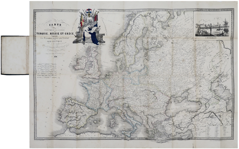
ANDRIEU (J. B.).
Carte [du] théâtre de la guerre en Turquie, Russie et Grèce donnant les royaumes neutres qui bordent la mer Baltique.
Paris, chez l'auteur, 1854. 571 x 856 mm, replié et monté dans une reliure en percaline verte avec étiquette illustrée sur le premier plat.
Bookseller reference : LBW-6420
|
|
|
Andrist Ralph K. and maps by Rafael De Palacios
The Long Death-Last Days of the Plains Indian
Hardcover. Good. Good solid ex-library copy with clean unmarked text plus the usual labels card pocket etc. Like the one pictured this copy also has no dust jacket other than the clear protective one the library attached. hardcover
Bookseller reference : NM-EK3Y-ERVO
|
|
|
Andrist Ralph K; maps by Rafael D. Palacios
The Long Death: The Last Days of the Plains Indians
New York: Macmillan. 371 pages spine ends rubbed strips on endpapers browned very good in browned foxed moderately worn dust jacket chipped at spine ends and corners now in protective Brodart cover. Multiple black and white photographs and . Very Good. Hardcover. First printing. 1964. Macmillan hardcover
Bookseller reference : 60508
|
|
|
Andriveau, E. und Goujon:
Carte de l`Algérie, d`après les cartes de l`Etat-Major et les documents du Ministère de la Guerre. Aus "Atlas Usuel"
45 x 62 cm (Blattgröße: 70 x 52,5 cm). *Sauber und gut erhalten. Landkarten fr
|
|
|
Andriveau, E. und Goujon:
Carte des Îles Britanniques. Aus: "Atlas Usuel".
62 x 46 cm. (Blattgröße: 70 x 52,5 cm). *Sauber und gut erhalten. Landkarten fr
|
|
|
Andriveau, E.:
Palestine ancienne et moderne d`après les sources les plus authentiques. Aus "Atlas Usuel"
46 x 62 cm (Blattgröße: 70 x 52,5 cm). *Hinterlegter Randeinriss im linken Falz, sonst sauber und gut erhalten. Landkarten fr
|
|
|
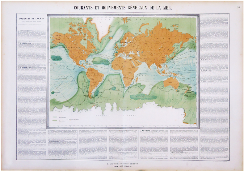
ANDRIVEAU-GOUJON (Eugène) & MAURY (Matthew Fontaine).
Courants et mouvements généraux de la mer.
Paris, E. Andriveau-Goujon, 1864. 660 x 886 mm.
Bookseller reference : LBW-6828
|
|
|
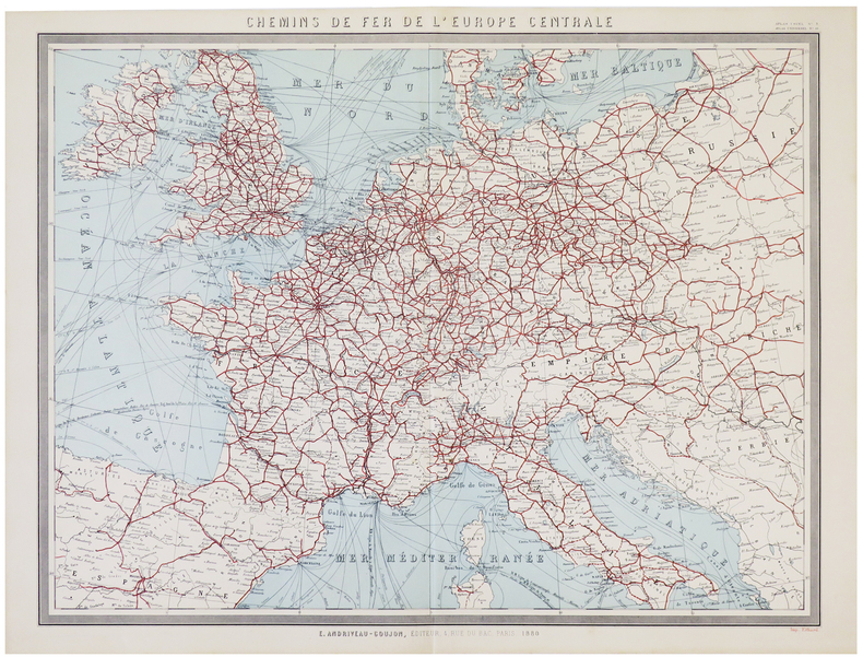
ANDRIVEAU-GOUJON (Eugène).
[CHEMINS de FER] Chemins de fer de l'Europe centrale.
Paris, E. Andriveau-Goujon, 1880. 503 x 637 mm.
Bookseller reference : LBW-5785
|
|
|
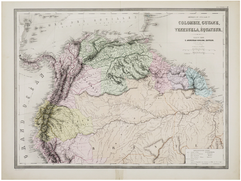
ANDRIVEAU-GOUJON (Eugène).
[COLOMBIE, GUYANE, VENEZUELA & ÉQUATEUR] Amérique du Sud. Feuille 1ère. Colombie, Guyane, Venezuela, Équateur.
Paris, E. Andriveau-Goujon, 1858. 470 x 635 mm.
Bookseller reference : LBW-6095
|
|
|
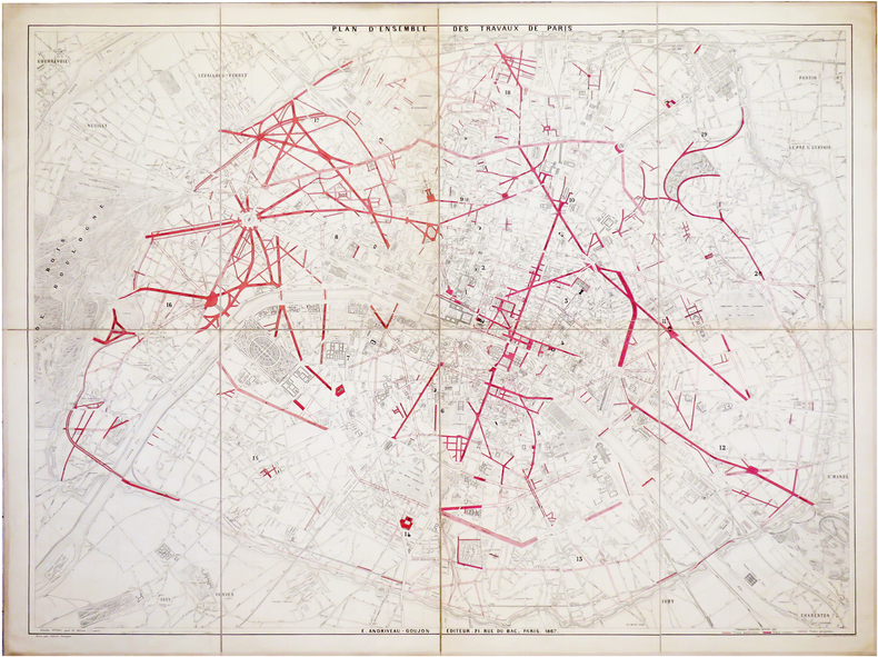
ANDRIVEAU-GOUJON (Eugène).
[TRAVAUX d'HAUSSMANN] Plan d'ensemble des travaux de Paris.
Paris, E. Andriveau-Goujon, 1867. En 8 sections montées sur toile et pliées, formant un plan de 0,99 x 1,30 m.
Bookseller reference : LBW-6483
|
|
|
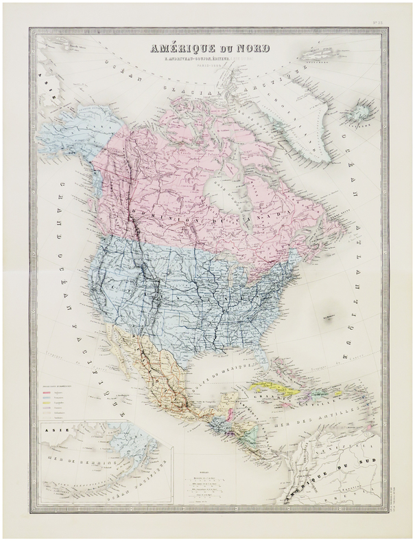
ANDRIVEAU-GOUJON (Eugène).
Amérique du Nord.
Paris, E. Andriveau-Goujon, 1880. 624 x 460 mm.
Bookseller reference : LBW-5799
|
|
|
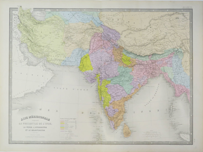
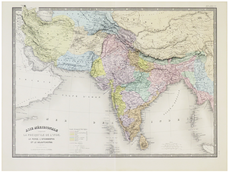
ANDRIVEAU-GOUJON (Eugène).
Asie méridionale comprenant la presqu'île de l'Inde, la Perse, l'Afghanistan et le Beloutchistan.
Paris, E. Andriveau-Goujon, 1889. 462 x 622 mm.
Bookseller reference : LBW-3621
|
|
|
ANDRIVEAU-GOUJON (Eugène).
Asie méridionale comprenant la presqu'île de l'Inde, la Perse, l'Afghanistan et le Beloutchistan.
Paris, E. Andriveau-Goujon, 1876. 463 x 628 mm.
Bookseller reference : LBW-5793
|
|
|
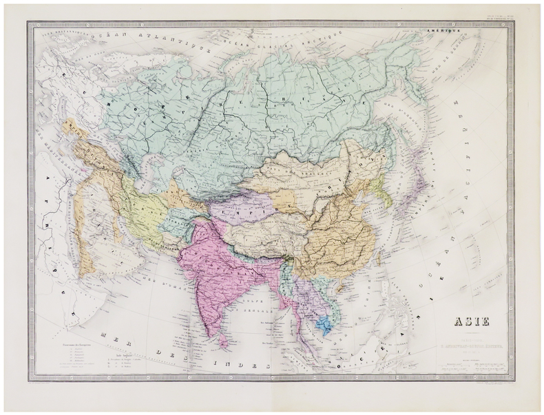
ANDRIVEAU-GOUJON (Eugène).
Asie.
Paris, E. Andriveau-Goujon, 1879. 463 x 627 mm.
Bookseller reference : LBW-5792
|
|
|
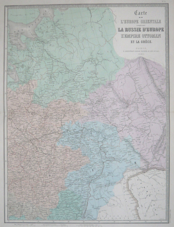
ANDRIVEAU-GOUJON (Eugène).
Carte de l'Europe orientale comprenant la Russie d'Europe, l'empire ottoman et la Grèce.
Paris, E. Andriveau-Goujon, 1863. En deux feuilles, chacune de 618 x 464 mm.
Bookseller reference : LBW061e9
|
|
|
ANDRIVEAU-GOUJON (Eugène).
Carte de l'Europe orientale comprenant la Russie d'Europe, l'Empire ottoman et la Grèce.
Paris, E. Andriveau-Goujon, 1877. En quatre feuilles pouvant être jointes pour former une carte de 1,24 x 0,90 m.
Bookseller reference : LBW-5791
|
|
|
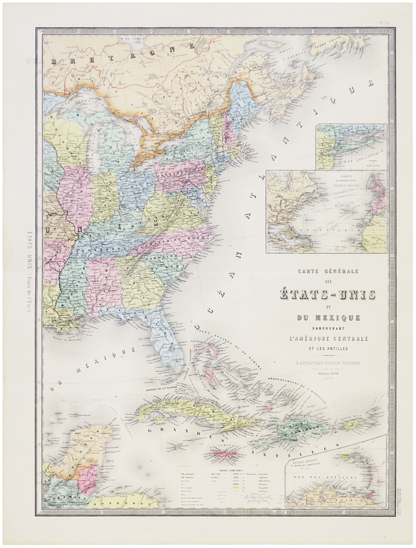
ANDRIVEAU-GOUJON (Eugène).
Carte générale des États-Unis et du Mexique comprenant l'Amérique Centrale et les Antilles.
Paris, E. Andriveau-Goujon, 1876. En deux feuilles pouvant être jointes pour former une carte de 623 x 900 mm.
Bookseller reference : LBW-5800
|
|
|
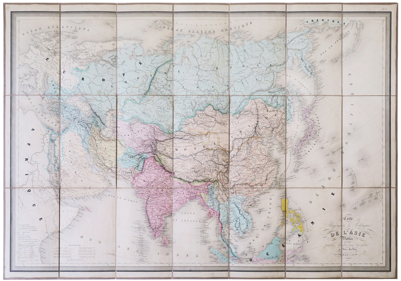
ANDRIVEAU-GOUJON (Eugène).
Carte physique & politique de l'Asie.
Paris, E. Andriveau-Goujon, 1861. En 21 sections montées sur toile et pliées, formant une carte de 673 x 943 mm, sous chemise et étui de papier marbré bleu, étiquette illustrée de l'éditeur E. Andriveau-Goujon au dos.
Bookseller reference : LBW-5129
|
|
|
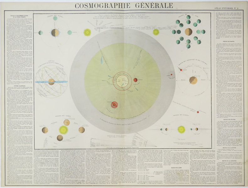
ANDRIVEAU-GOUJON (Eugène).
Cosmographie générale.
[circa 1880]. 513 x 669 mm.
Bookseller reference : LBW-3532
|
|
|
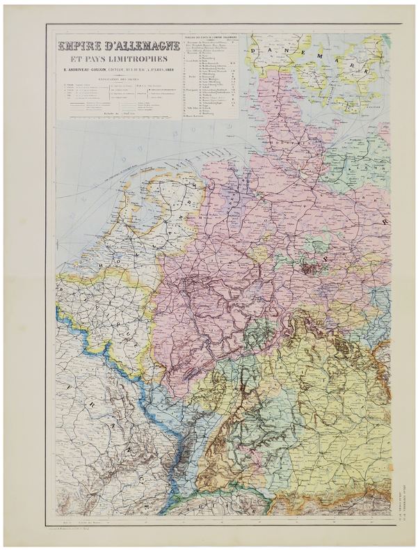
ANDRIVEAU-GOUJON (Eugène).
Empire d'Allemagne et pays limitrophes.
Paris, E. Andriveau-Goujon, 1880. En deux feuilles pouvant être jointes pour former une carte de 645 x 880 mm.
Bookseller reference : LBW-5790
|
|
|
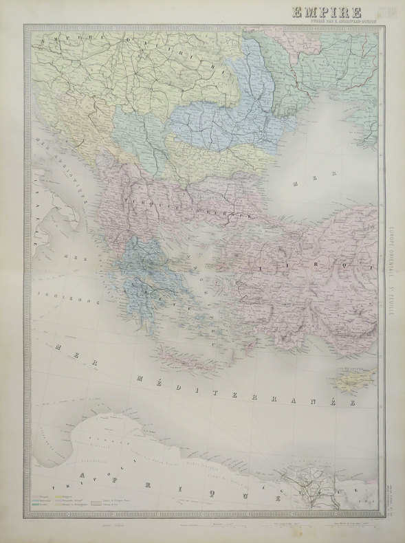
ANDRIVEAU-GOUJON (Eugène).
Empire Ottoman.
Paris, E. Andriveau-Goujon, 1889. En deux feuilles pouvant être jointes pour former une carte de 655 x 900 mm.
Bookseller reference : LBW-3622
|
|
|
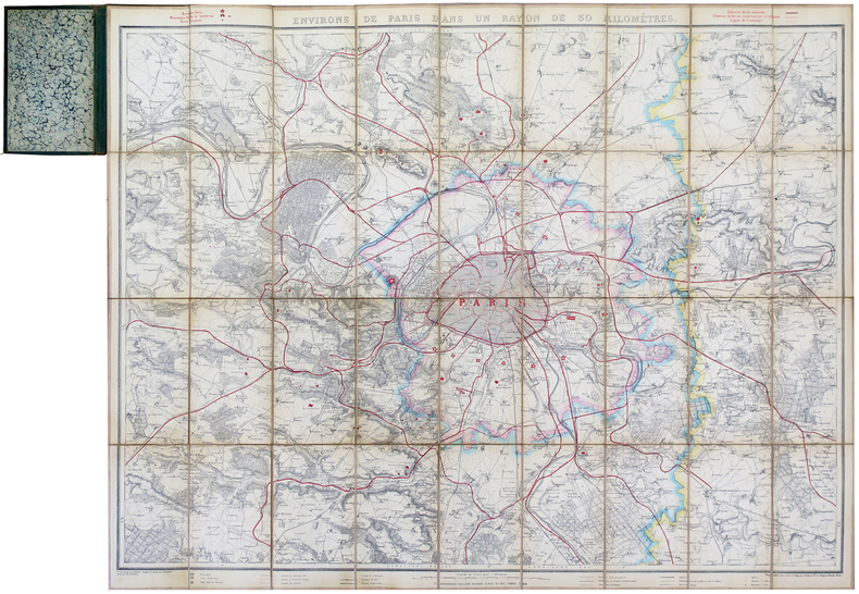
ANDRIVEAU-GOUJON (Eugène).
Environs de Paris dans un rayon de 30 kilomètres.
Paris, E. Andriveau-Goujon, 1881. En 36 sections montées sur toile et pliées, formant une carte de 0,83 x 1,05 m, monté dans une reliure en percaline de couleur verte avec titre en lettres dorées sur le premier plat ; étiquette de l'éditeur au dos du plan.
Bookseller reference : LBW-5659
|
|
|
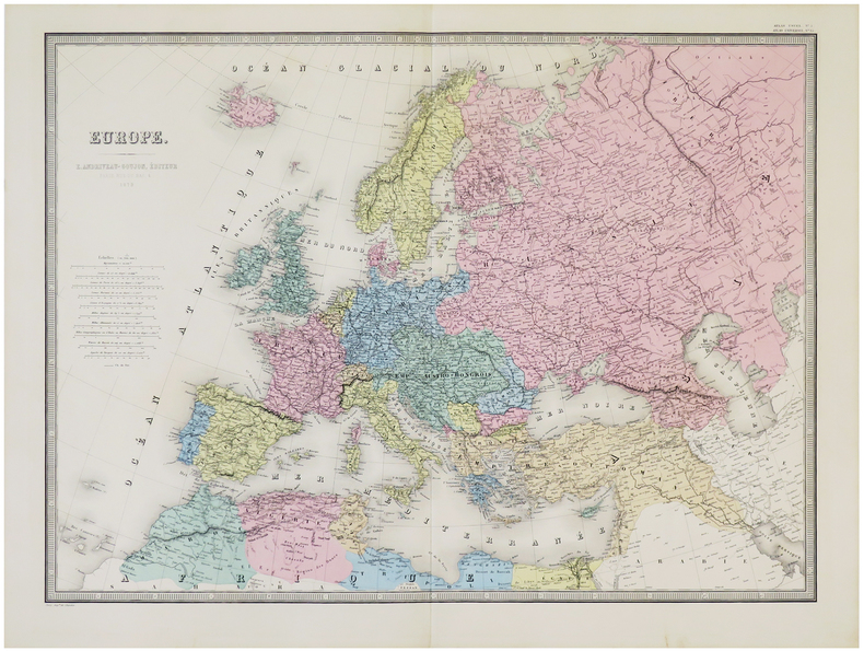
ANDRIVEAU-GOUJON (Eugène).
Europe.
Paris, E. Andriveau-Goujon, 1879. 462 x 626 mm.
Bookseller reference : LBW-5784
|
|
|
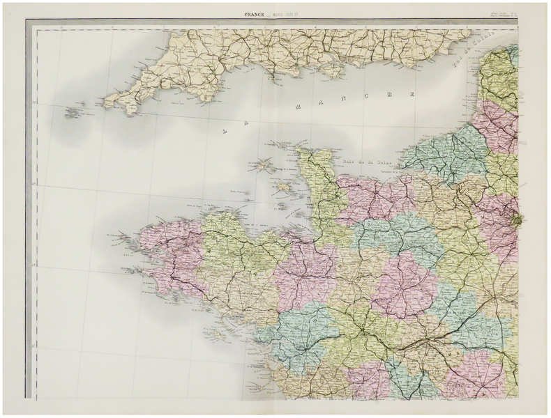
ANDRIVEAU-GOUJON (Eugène).
France.
Paris, E. Andriveau-Goujon, 1880. En quatre feuilles pouvant être jointes pour former une carte de 0,97 x 1,26 m.
Bookseller reference : LBW-5788
|
|
|
ANDRIVEAU-GOUJON (Eugène).
Italie.
Paris, E. Andriveau-Goujon, 1881. 622 x 460 mm.
Bookseller reference : LBW-5789

|
|
|
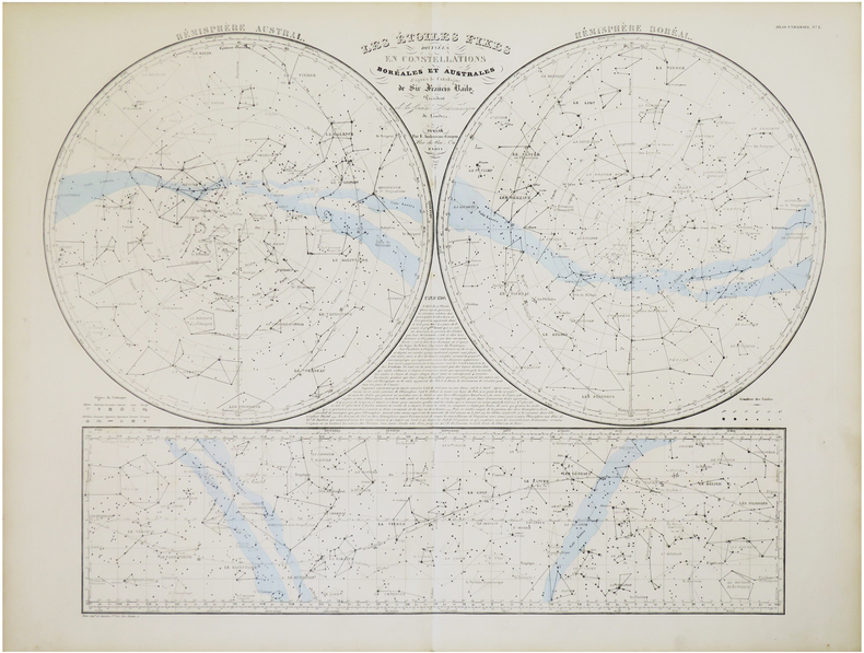
ANDRIVEAU-GOUJON (Eugène).
Les étoiles fixes divisées en constellations boréales et australes d'après le catalogue de Sir Francis Baily, Président de la Société Astronomique de Londres.
Paris, E. Andriveau-Goujon,. 1860 478 x 632 mm.
Bookseller reference : LBW-7847
|
|
|
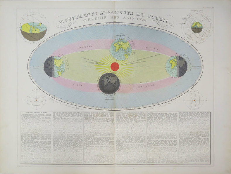
ANDRIVEAU-GOUJON (Eugène).
Mouvements apparents du Soleil, théorie des saisons.
Paris, E. Andriveau-Goujon, [circa 1880]. 470 x 587 mm.
Bookseller reference : LBW-3624
|
|
|
ANDRIVEAU-GOUJON (Eugène).
Pavillons et cocardes des principales puissances du globe d'après des documens officiels.
Paris, E. Andriveau-Goujon, 1860. 460 x 582 mm.
Bookseller reference : LBW-5148

|
|
|
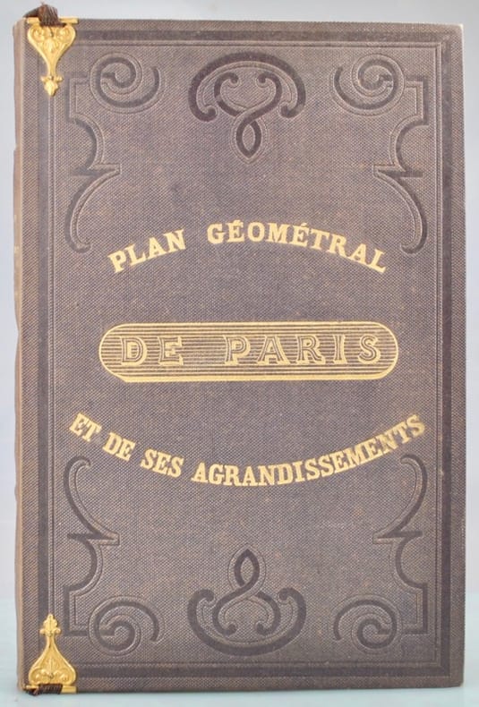
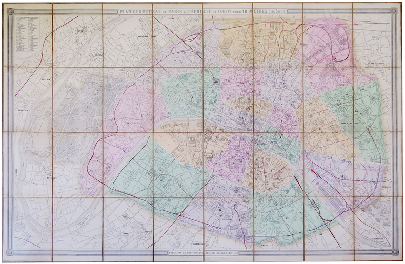
ANDRIVEAU-GOUJON (Eugène).
Plan géométral de Paris et de ses agrandissements à l'échelle d'un millimètre pour 10 m (10,1000).
Paris, E. Andriveau-Goujon, 1860. En 36 sections jointes et montées sur toile, de 1 x 1,49 m.
Bookseller reference : LBW-3410

|
|
|
ANDRIVEAU-GOUJON (Eugène).
Plan géométral de Paris et de ses agrandissements à l'échelle d'un millimètre pour 10 m (10,1000).
Paris, E. Andriveau-Goujon, 1862. En 36 sections jointes et montées sur toile, formant un plan de 1,04 x 1,54 m ; étiquette de l'éditeur au dos ; plan placé dans une chemise en percaline verte de l’éditeur avec une pochette contenant la liste des rues sur 27 pages, titre en lettres dorées sur le premier plat et sur le dos, marque de l’éditeur sur le second plat figurant un globe terrestre centré sur Paris, petites pinces métalliques retenant un ruban (détaché) sur le premier plat.
Bookseller reference : LBW-6294

|
|
|
ANDRIVEAU-GOUJON (Eugène).
Plan géométral de Paris et de ses agrandissements, à l'échelle de 1 millimètre pour 10 mètres.
Paris, Andriveau-Goujon, 1861. 1 plan colorié, replié et entoilé de 154 x 104 cm, et 1 livret in-8 de 28 pp., couverture imprimée, percaline brune de l'éditeur.
Bookseller reference : 42235
|
|
|
ANDRIVEAU-GOUJON (Eugène).
Plan géométral de Paris à l'échelle de 0.001 pour 10 mêtres (1/10,000).
Paris, E. Andriveau-Goujon, 1879. En 32 sections jointes et montées sur toile de 1,05 x 1,56 m ; étiquette de l'éditeur au dos.
Bookseller reference : LBW-5725
|
|
|
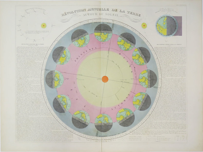
ANDRIVEAU-GOUJON (Eugène).
Révolution annuelle de la Terre autour du Soleil.
Paris, E. Andriveau-Goujon, [circa 1880]. 469 x 586 mm.
Bookseller reference : LBW-3623
|
|
|
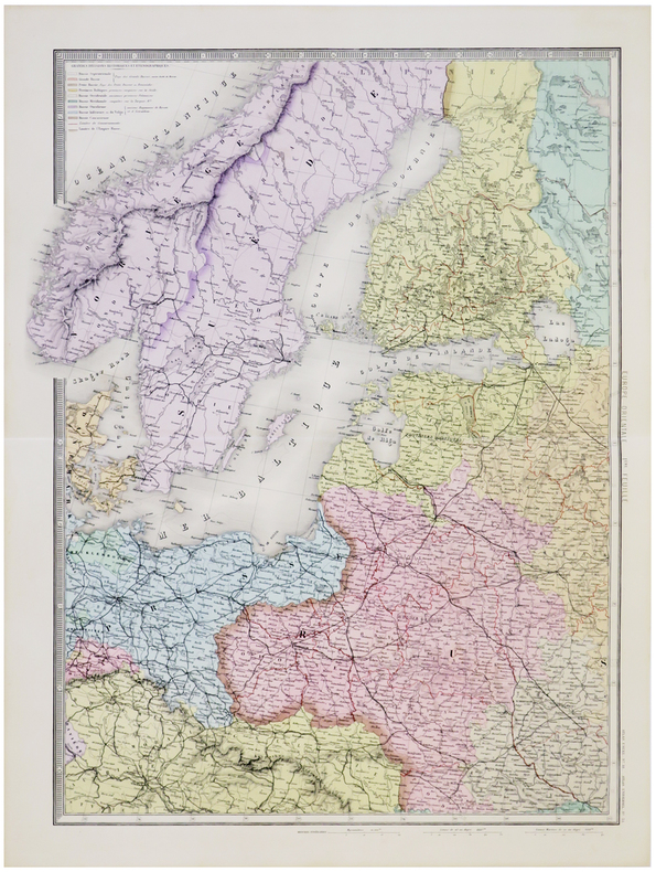
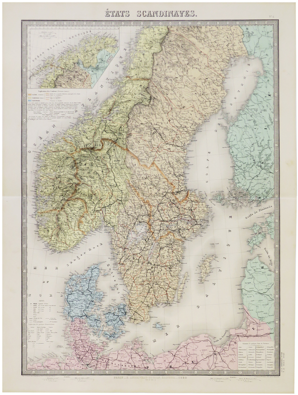
ANDRIVEAU-GOUJON (Eugène).
États scandinaves.
Paris, E. Andriveau-Goujon, 1880. 660 x 462 mm.
Bookseller reference : LBW-5786
|
|
|
ANDRIVEAU-GOUJON (J.)
Les Etoiles fixes divisées en constellations Boréales et Australes d'après le catalogue de Sir Francis Baily
1830 pliée. carte 63 x 88 cms. P. Andriveau-Goujon (ca. 1830)
Bookseller reference : 11804
|
|
 Receive by email
 Download as PDF document
 RSS feed


