|
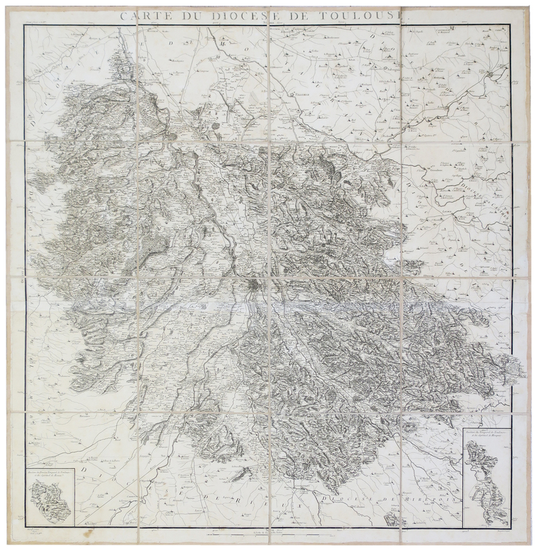
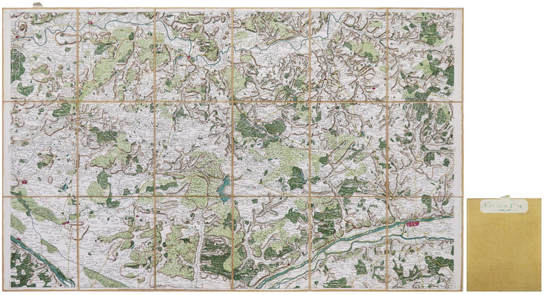
CASSINI de THURY (César-François) & CAPITAINE (Louis).
[TOULOUSE] Carte du diocèse de Toulouse.
[1781]. En 16 sections montées sur toile et pliées, formant une carte de 980 x 950 mm.
Bookseller reference : LBW-2807
|
|
|
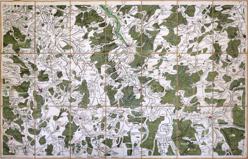
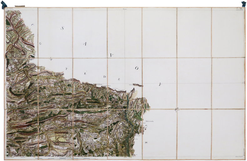
CASSINI de THURY (César-François).
[TOUL] Carte de Cassini. Feuille n°41.
[Paris, 1756-1789]. En 21 sections montées sur toile et pliées, formant une carte de 595 x 930 mm ; étiquette au dos et onglet portant le numéro de la feuille.
Bookseller reference : LBW-3994
|
|
|
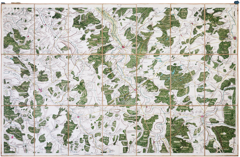
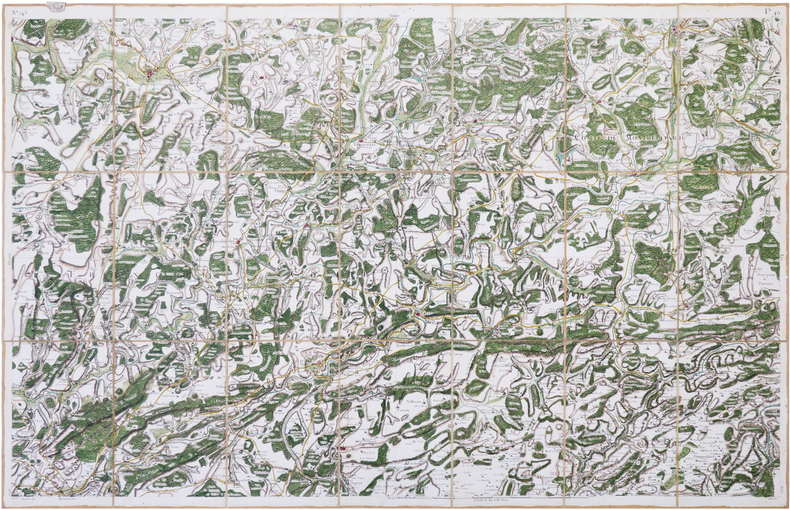
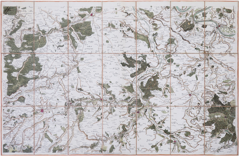
CASSINI de THURY (César-François).
[TOUL] Carte de Cassini. Feuille n°111/41. Toul.
[Paris, 1756-1789]. En 21 sections montées sur toile et pliées, formant une carte de 592 x 926 mm ; étiquette au dos portant le titre "Toul" et le numéro en manuscrit, onglet de soie.
Bookseller reference : LBW-7202
|
|
|
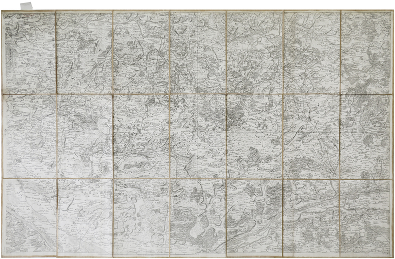
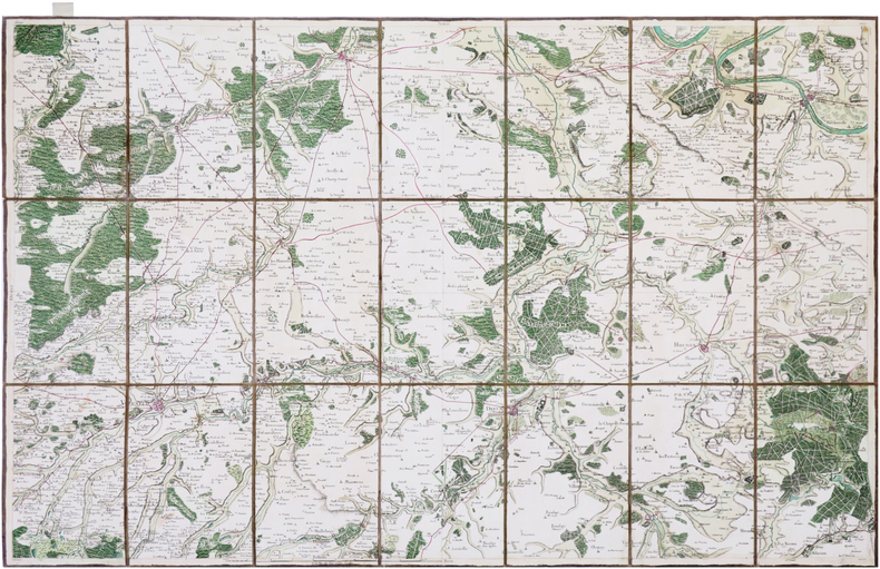
CASSINI de THURY (César-François).
[TOURS] Carte de Cassini. Feuille n°65/78. Tours.
[Paris, 1756-1789]. En 21 sections montées sur toile et pliées, formant une carte de 584 x 922 mm ; étiquette au dos de l'éditeur Auvray, onglet de vélin renseigné du numéro de la feuille.
Bookseller reference : LBW-7381
|
|
|
CASSINI de THURY (César-François).
[TOURS] Carte de Cassini. Feuille n°65/78. Tours.
[Paris, 1765]. En 18 sections montées sur toile et repliées, formant une carte de 579 x 941 mm ; onglet de vélin renseigné du numéro de la feuille à l'encre verte, étiquette au dos portant le numéro et le titre de la feuille à l'encre verte.
Bookseller reference : LBW-8663
|
|
|
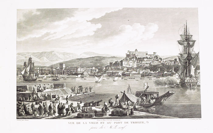
CASSAS (Louis-François).
[TRIESTE] Vue de la ville et du port de Trieste, prise du Môle neuf.
[Paris, 1802]. 270 x 405 mm.
Bookseller reference : LBW-823
|
|
|
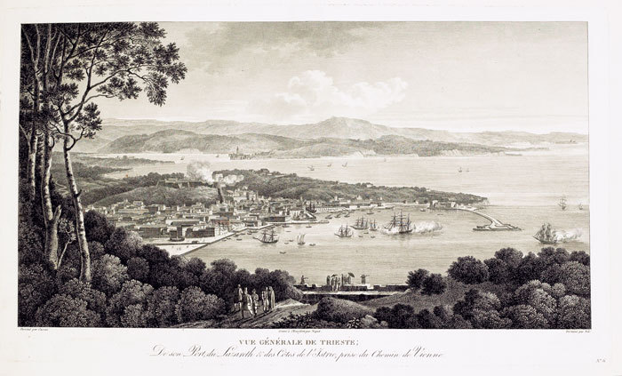
CASSAS (Louis-François).
[TRIESTE] Vue générale de Trieste, de son port, du Lazareth & des côtes de l’Istrie, prise du chemin de Vienne.
[Paris, 1802]. 266 x 451 mm.
Bookseller reference : LBW-824
|
|
|
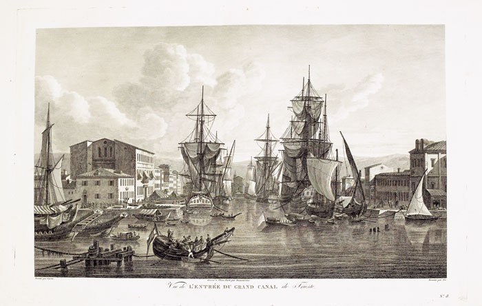
CASSAS (Louis-François).
[TRIESTE] Vue de l’entrée du grand canal de Trieste.
[Paris, 1802]. 252 x 399 mm.
Bookseller reference : LBW-825
|
|
|
CASSINI de THURY (César-François).
[VENCE/ENTREVAUX] Carte de Cassini. Feuille n°166/147. Vence.
[Paris, 1756-1789]. En 21 sections montées sur toile et pliées, formant une carte de 589 x 924 mm ; étiquette au dos portant le titre "Vence" et le numéro en manuscrit, onglet de soie renseigné du numéro de la feuille.
Bookseller reference : LBW-7136
|
|
|
CASSINI de THURY (César-François).
[VESOUL] Carte de Cassini. Feuille n°145/49. Vesoul.
[Paris, 1759]. En 21 sections montées sur toile et repliées, formant une carte de 592 x 926 mm ; onglet de vélin renseigné du numéro de la feuille ; étiquette au dos portant le titre et le numéro en manuscrit.
Bookseller reference : LBW-8042
|
|
|
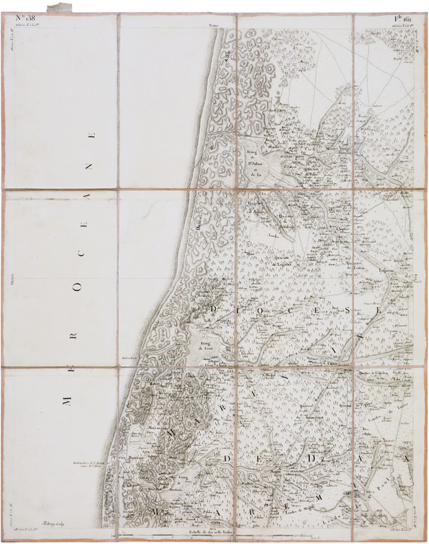
CASSINI de THURY (César-François).
[VIEUX-BOUCAU-les-BAINS] Carte de Cassini. Feuille n°138/162. Vieux-Boucau-les-Bains.
[Paris, 1756-1789]. En 12 sections montées sur toile et pliées, formant une carte de 598 x 484 mm ; étiquette au dos de l'éditeur Charles Picquet, onglet de vélin renseigné du numéro de la feuille.
Bookseller reference : LBW-7377
|
|
|
CASSINI de THURY (César-François).
[VIVIERS] Carte de Cassini. Feuille n°90/123. Viviers.
[Paris, 1779]. En 21 sections montées sur toile et repliées, formant une carte de 600 x 930 mm ; étiquette de l'éditeur parisien Vignon contrecollée au bas de la carte ; étiquette au dos portant le titre manuscrit au stylo bille ; onglet de vélin renseigné du titre et du numéro de la feuille.
Bookseller reference : LBW-8418

|
|
|
CASSINI de THURY (César-François).
[ÉVREUX] Carte de Cassini. Feuille n°26/7. Évreux.
[Paris, 1756-1789]. En 21 sections montées sur toile et pliées, formant une carte de 584 x 931 mm ; étiquette au dos portant le titre "Evreux" en manuscrit, onglet de vélin renseigné du numéro de la feuille.
Bookseller reference : LBW-7359
|
|
|
CASSINI de THURY (César-François).
[ÉVREUX/DREUX] Carte de Cassini. Feuille n°26/7. Évreux.
[Paris, 1757]. En 21 sections montées sur toile et repliées, formant une carte de 595 x 923 mm.
Bookseller reference : LBW-8028
|
|
|
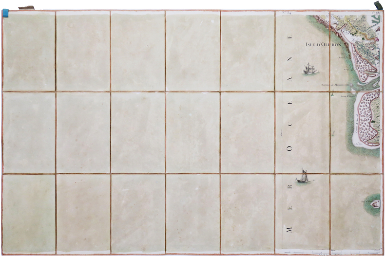
CASSINI de THURY (César-François).
[ÎLE d'OLÉRON] Carte de Cassini. Feuille n°134/88. Île d'Oléron.
[Paris, 1756-1789]. En 21 sections montées sur toile et pliées, formant une carte de 594 x 920 mm ; étiquette au dos portant le titre "Isle d'Oléron" et le numéro en manuscrit, onglet de soie renseigné du numéro de la feuille.
Bookseller reference : LBW-7006
|
|
|
CASSINI.
Bourg en Bresse : Carte N° 117
toilée. Paris
Bookseller reference : 12400
|
|
|
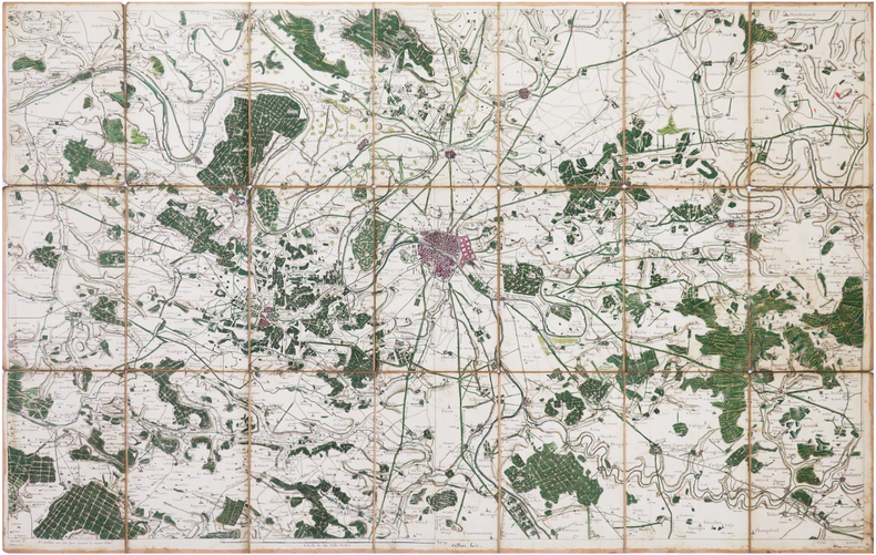
CASSINI de THURY (César-François).
Carte de Cassini. Feuille n°1/1. Paris.
[Paris, 1756]. En 21 sections montées sur toile et repliées, formant une carte de 585 x 920 mm ; étiquette au dos portant le titre en manuscrit et un envoi "à Mr Leclercq architecte à Versailles avenue de St Cloud n°17".
Bookseller reference : LBW-7900
|
|
|
CASSINI
Cartes N° 112, 142, 144, 163 correspondant à : Colmar, Nancy, Luxeuil et Joinville,
1790 étui en cartonnage parcheminé vert, piece de titre rouge. toile vieux rose, coloriées
Bookseller reference : 6884
|
|
|
CASSINI
Carte N° 152 : Laragne , Embrun.
Carte 590 x 1170 mm., toile saumon XVIIIe.
Bookseller reference : 11535
|
|
|
CASSINI
Carte N° 166 Vence
toile saumon XVIIIe. H 59 L 66 cms.
Bookseller reference : 11536
|
|
|
CASSINI
Carte N° 167 Fréjus Antibes.
toile saumon XVIIIe. H 60 L 53 cms.
Bookseller reference : 11539
|
|
|
CASSINI.
Carte N°46 : Provins, Sens, Nogent, Montereau
couleurs, carte toilée,
Bookseller reference : 11860
|
|
|
CASSINI.
Carte N° 47 : Auxerre, Joigny
couleurs, carte toilée,
Bookseller reference : 11861
|
|
|
CASSINI.
Carte N° 48 : Vermanton, Cosne, Donzy, Clamecy.
couleurs, carte toilée,
Bookseller reference : 11862
|
|
|
CASSINI
Carte N° 62 : Argentan
coloriée, toilée.
Bookseller reference : 11864
|
|
|
CASSINI
Carte N° 45 : Meaux; La Ferté sous Jouarre, Montmirail, Coulommiers.
coloriée, toilée.
Bookseller reference : 11865
|
|
|
CASSINI
Carte N° 83 : Montbar, Flavigny, Sémur, Avallon.
coloriée, toilée.
Bookseller reference : 11868
|
|
|
CASSINI
Carte de Cassini N° 78. Charleville-Mézière.
1800 carte usagée. 21 sections montées sur toile et pliées, formant une carte de 610 x 930 mm. P. s.d., 1800
Bookseller reference : 16325
|
|
|
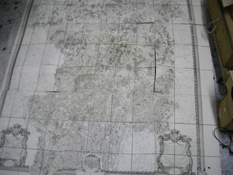
CASSINI, CAMUS, MONTIGNY (de)
Carte particulière du Duché de Bourgogne levée géométriquement par ordre de MM. les Elus Généraux de la Province en conséquence du Décret des Etats de 1751, divisée par Diocèses, Baillages et Subdélégations, faisant partie de la Carte Générale de la France levée par ordre du Roy et par les Ingénieurs Géographes de Sa Majesté, sous la direction de Mrs Cassini, Camus & de Montigny, de l'Académie Rle des Sciences. Dressée et executée par le Sr Seguin, ingénieur géographe du roy en 1763. Echelle de dix mil Toises. Les Ornemens d'après les desseins du Sr. Galey, Inspectr. des Batiments du Roy. L'Ecriture par Bourguignon. N° 1 : Confins de la Champagne. Cours de l'Armençon, de l'Yonne...N° 2 : Confins de la Champagne. Cours de la Marne, de l'Aube et de la SeineN° 3 : Confins de la Lauraine et de la Franche-Comté.N° 4 : Confins du Nivernois.N° 5 : Centre de la Bourgogne.N° 6 : Confins de la Franche-Comté. Cours de la Saone, du DoubsN° 7 : Confins du Bourbonois. Cours de la Loire et de l'Arroux.N° 8 : Confins de la Bresse. Cours de la Saone.N° 9 : Confins de la Franche-Comté.
1763 toile, dans un emboitage 35 x 25 x 7 cm (XIXe sur laquelle on a placé l'étiquette XVIIIe). carte composée de 9 feuilles, 290 x 246 cms, 1763
Bookseller reference : 17704
|
|
|
CASSINI
CARTE de la région de TOUL n°111 flle 41 (1759)
De format 920 X 600, entoilage d'époque, avec la vignette imprimée du libraire (le Sr Desnos, rue St Jacques ), la carte est divisée en 21 parties permettant le pliage en accordéon sans dommage pour le papier. Exemplaire en couleurs, forêts, bourgs importants. 1759.
Bookseller reference : 2353

|
|
|
CASSINI
Carte n°44 (région de Soissons)
De format 930 X 600, entoilage d'époque, pliage en 18 parties. Imprimée en noir en 1757. Avec les forêts de Compiègne et de Villers-Cotterets. Figurent La Ferté Millon, , Etrepilly, Chatillon, la rivière l'Ourcq et un méandre de la Marne au sud. Bon exemplaire, quelques taches claires (traces d'humidité). Vignette imprimée de marchand d'estampes au quai Voltaire sur la toile du premier pli.
Bookseller reference : 2364

|
|
|
CASSINI
Carte n°45 MEAUX Coulommiers Montmirail Chateau Thierry La Ferté Gaucher
De format 920 X 595, entoilage d'époque, pliage en 21 parties. Impression en couleurs de 1757. Vignette ronde gravée du libraire et Ingénieur géographe Desnos à Paris, contrecollée sur la toile au premier pli. Bon exemplaire.
Bookseller reference : 2367

|
|
|
CASATI Gaetano:
Dix années en Équatoria. Le retour d'Emin Pacha et l'Expédition Stanley. Ouvrage traduit avec l'autorisation de l'auteur par Louis de Hessem.
Paris, Librairie de Firmin Didot, 1892. In-4 de XI-[1]-498-[2] pages, demi-chagrin rouge à coins, dos à nerfs ornés de filets et fleurons dorés, tête dorée.
Bookseller reference : 20576

|
|
|
CASSINI César François (dit Cassini de Thury - d'après)
ILLE ET VILAINE, MAYENNE, SARTHE ET ENVIRONS, d'après Cassini et le dépôt de la guerre, BRETAGNE, MAINE
1899 carte entoilée (map cloth-lined map), dimensions de la carte dépliée (Dimensions of the unfolded map - size in Inches) : 79 centimètres de largeur (width : 31.10) sur 58.5 de hauteur (height : 23.03), sans date imprimée (undated printed) - circa milieu dix-neuvième siècle - à Paris à la Géographie de H. Langlois rue du Poi de Fer Saint Sulpice - imprimé chez Kaeppelin 15 quai voltaire,
Bookseller reference : 15740
|
|
|
Castela Paul
Jean Giletta 1856 - 1933. Un Photographe à La Recherche de son Temps.Préface de Mme Janine Grisoni-Gilletta.
1981 Gillleta, Nice, 1981. In-4 reliure d'éditeur toile noire sous jaquette illustrée "1er éditeur photographe de la Côte-d'Azur". 456 pages. Ouvrage illustré de 600 photographies en noir. Très bel ouvrage.
Bookseller reference : 24840
|
|
|
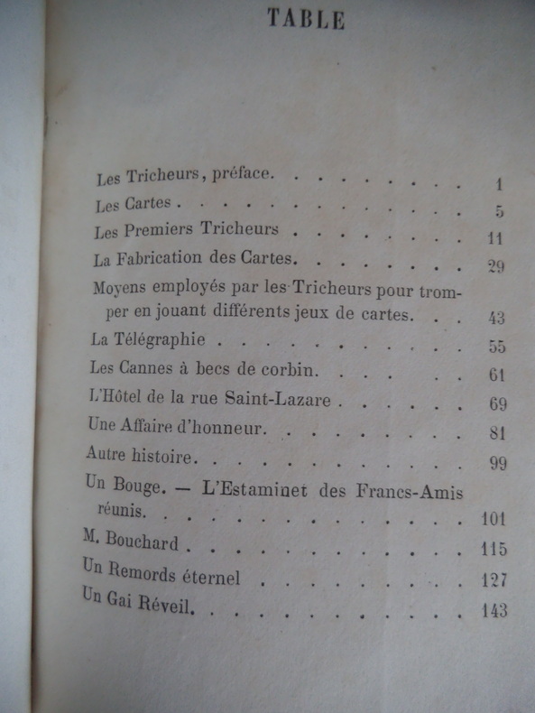
CASTON Alfred (de)
Les tricheurs scènes de jeu
in 12 demi-cuir rouge,dos lisse,titre et filets dorés. photographie de l’auteur en pied par CARJAT avec sa signature d’atelier gaufrée fau-titre,titre 265 pages,1 feuillet d’errata,Dentu éditeur 1863.une tache brun-clair en marge supérieure en début de volume en s’atténuant jusqu’à la page 36 pour être pratiquement invisible jusqu’à la fin.une petite déchirure circulaire avec manque de papier(restauré)à la page de titre sous les initiales ED de l’éditeur rare ouvrage
Bookseller reference : 2511
|
|
|
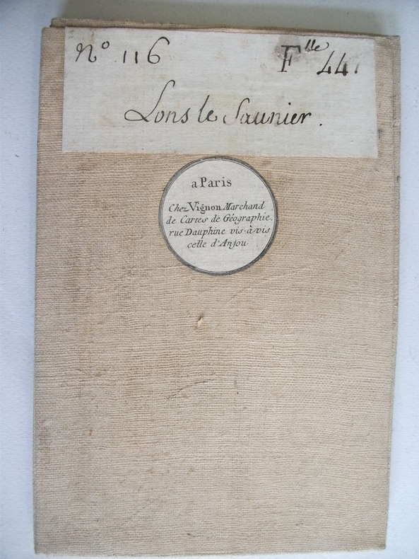
CASSINI de THORY
LONS LE SAUNIER
Vignon marchand de cartes de géographie Paris. N°116 feuille 44 ,LONS LE SAUNIER,carte entoilée.,Pliée 13x20cm dépliée 90x60 échelle 10 000 toises
Bookseller reference : 6736
|
|
|
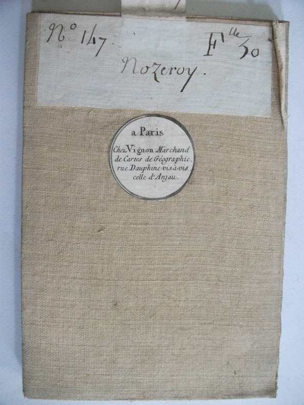
CASSINI de THORY
NOZEROY carte entoilée.
marchand de cartes de géographie Paris. N°147 feuille 30 NOZEROY carte entoilée.Pliée 13x20cm dépliée 90x60 échelle 10 000 toises.
Bookseller reference : 6734
|
|
|
CASAÑAL Y ZAPATERO, Dionisio.
Bosquejo Geográfico de la Provincia de Zaragoza formado por encargo de la Excelentísima Diputación Provincial para servir de base al Plan General de Caminos Vecinales.
Zaragoza, Litografía de E. Portabella y Compañía, 1903. Mapa de 122 x 126 cms. litografíado en color, montado sobre tela y plegado. Ejemplar con envío auógrafo de Dionisio Casañal. Encuadernación de época en tela.

|
|
|
CASSINI Giovanni Maria (1745 - 1824)
Emisfero Terrestre Meridionale delineato secondo le ultime Osservazioni - Emisfero Terrestre Settentrionale Delineato second
Coppia di carte del mondo, con proiezione polare, tratta dal Nuovo Atlante Geografico Universale delineato sulle ultime osservazioni, edito a Roma dal 1792 fino al 1801, opera che la Calcografia Camerale commissionò al Cassini al fine di sostituire l’ormai obsoleto Mercurio Geografico della tipografia De Rossi. Elegante mappa che mostra i risultati delle esplorazioni fornite dai viaggio di James Cook, comprese le Isole Sandwich (Hawaii). Giovanni Maria Cassini, chierico regolare somasco fu geografo e cartografo, ma anche intagliatore di architetture e prospettive - uno dei migliori discepoli di Giovanni Battista Piranesi. Cassini fu uno degli ultimi sfereografi italiani del Settecento ed i suoi globi ebbero una notevole diffusione, come pure questo Nuovo Atlante Geografico. Incisioni in rame, finemente colorate nei contorni, in ottimo stato di conservazione. Uncommon maps, published in the Nuovo Atlante Geografico Universale, with a decorative title cartouche, by Giovanni Maria Cassini. The Nuovo Atlante Geografico Universale, was commissioned to Cassini by the Calcografia Camerale, in order to replace the obsolete De Rossi's Mercurio Geografico. Elegant map of Northern and Southern Hemisphere, showing results of Cooks explorations, including Sandwich Islands. Highly embellished with two sets of birds carrying reaths and 2 sets of female centaurs and fishlike creatures supporting tables on either side of map. Cassini was geographer and cartographer but he was also good at engraving architectural items and perspectives – he was one of the best disciples Giovanni Battista Piranesi had. Moreover, Cassini was one of the last artists to engrave spheres in the XVIII century and his globes were quite famous and widespread, and realized the most important Italian Atlas of the XVIII century; his maps always bear a cartouche, extremely rich in colours and details. Copperplates with fine later hand colour, in very good condition.

|
|
|
Cassini Historical Maps
Guildford and Godalming including Bramley Cranleigh East Clandon Hascombe Milford Puttenham Shalford Shamley Green Wonersh and Worplesdon GUG Cassini Past and Present Map
Cassini Publishing Ltd 2006. Map. New. Soft cover. paperback historic sheet maps showing four periods between 1816 and the present day in the development of the areas covered and laid side by side for comparison a new unused copy. Cassini Publishing Ltd Paperback
Bookseller reference : 202956 ISBN : 1847361099 9781847361097

|
|
|
Cassini Historical Maps
Guildford and Godalming including Bramley Cranleigh East Clandon Hascombe Milford Puttenham Shalford Shamley Green Wonersh and Worplesdon GUG Cassini Past and Present Map
Cassini Publishing Ltd 2006. Map. New. Soft cover. paperback historic sheet maps showing four periods between 1816 and the present day in the development of the areas covered and laid side by side for comparison a new unused copy. Cassini Publishing Ltd Paperback
Bookseller reference : 202955 ISBN : 1847361099 9781847361097

|
|
|
Cassini Historical Maps
Kidderminster & Stourport-on-Severn including Bewdley Dodford Droitwitch Spa Ombersley Summerfield and Wychbold PPR-KIS: Four Ordnance Survey Maps from Four Periods from 1831 to the Present Day Cassini Past and Present Map
Cassini Publishing Ltd 2007. Map. New. Soft cover. paperback historic sheet maps showing four periods in the development of the areas covered and laid side by side for comparison a new unused copy. Cassini Publishing Ltd Paperback
Bookseller reference : 202950 ISBN : 1847362672 9781847362674

|
|
|
Cassini Historical Maps
Kidderminster & Stourport-on-Severn including Bewdley Dodford Droitwitch Spa Ombersley Summerfield and Wychbold PPR-KIS: Four Ordnance Survey Maps from Four Periods from 1831 to the Present Day Cassini Past and Present Map
Cassini Publishing Ltd 2007. Map. New. Soft cover. paperback historic sheet maps showing four periods in the development of the areas covered and laid side by side for comparison a new unused copy. Cassini Publishing Ltd Paperback
Bookseller reference : 202949 ISBN : 1847362672 9781847362674

|
|
|
Cassini Historical Maps
Maidenhead Marlow and Bourne End including Bray Burnham Cookham Hare Hatch Holyport Hurley Knowl Hill Taplow Waltham St Lawrence and White Waltham MMB Cassini Past and Present Map
Cassini Publishing Ltd 2006. Map. New. Soft cover. paperback historic sheet maps showing four periods between 1822 and the present day in the development of the areas covered and laid side by side for comparison a new unused copy. Cassini Publishing Ltd Paperback
Bookseller reference : 202954 ISBN : 1847361129 9781847361127

|
|
|
Cassini Historical Maps
Map 176 West London 1:50000. Cassini Historical Map Revised New Series 1897-1909 including Borehamwood Croydon Rickmansworth Slough Staines Watford Weybridge and Windsor
Cassini Historical Maps. Map. Very Good. No Binding. Large folded map; in very good condition. . Cassini Historical Maps. unknown
Bookseller reference : 010816
|
|
|
Cassini Historical Maps 161
Map of The Black Mountains including Abergavenny Blaenavon Ebbw Vale Hay on Wye and Tredegar Popular Series No 161 1919-1920
Cassini Historical Maps 2006. Map. New. paperback. a reproduction of the original 1919 edition covering The Black Mountains revised and enlarged to match Ordnance Survey Landranger Map 161 a new copy of this folding map in colour. Cassini Historical Maps Paperback
Bookseller reference : 203248 ISBN : 1847362311 9781847362315

|
|
|
Cassini Historical Maps 135
Map of Aberystwyth & Machynlleth including Aberdyfi Borth Devil's Bridge and Tywyn Old Series 1833-1837
Cassini Historical Maps 2006. Map. New. paperback. a reproduction of the original revised and enlarged to match Ordnance Survey Landranger Map 135 a new copy of this folding map in b&w. Cassini Historical Maps Paperback
Bookseller reference : 167258 ISBN : 1847360491 9781847360496

|
|
|
Cassini Historical Maps 135
Map of Aberystwyth & Machynlleth including Aberdyfi Borth Devil's Bridge and Tywyn revised new series 1901-1903
Cassini Historical Maps 2007. Map. New. paperback. a reproduction of the original revised and enlarged to match Ordnance Survey Landranger Map 135 a new copy of this folding map in colour. Cassini Historical Maps Paperback
Bookseller reference : 167140 ISBN : 1847363989 9781847363985

|
|
|
Cassini Historical Maps 135
Map of Aberystwyth & Machynlleth including Aberdyfi Borth Devil's Bridge and Tywyn Old Series 1833-1837
Cassini Historical Maps 2006. Map. New. paperback. a reproduction of the original revised and enlarged to match Ordnance Survey Landranger Map 135 a new copy of this folding map in b&w. Cassini Historical Maps Paperback
Bookseller reference : 167257 ISBN : 1847360491 9781847360496

|
|
 Receive by email
 Download as PDF document
 RSS feed


