|
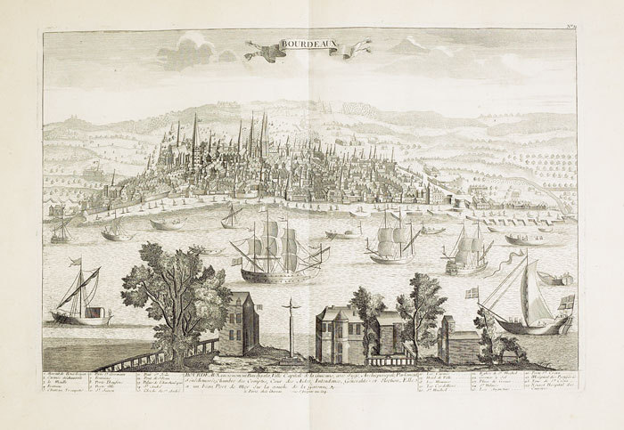
CHÉREAU (Jacques).
[BORDEAUX] Bourdeaux ancienement Burdigala, ville capitale de la Guienne.
Paris, Chéreau, [circa 1760]. 346 x 511 mm.
Bookseller reference : LBW-472
|
|
|
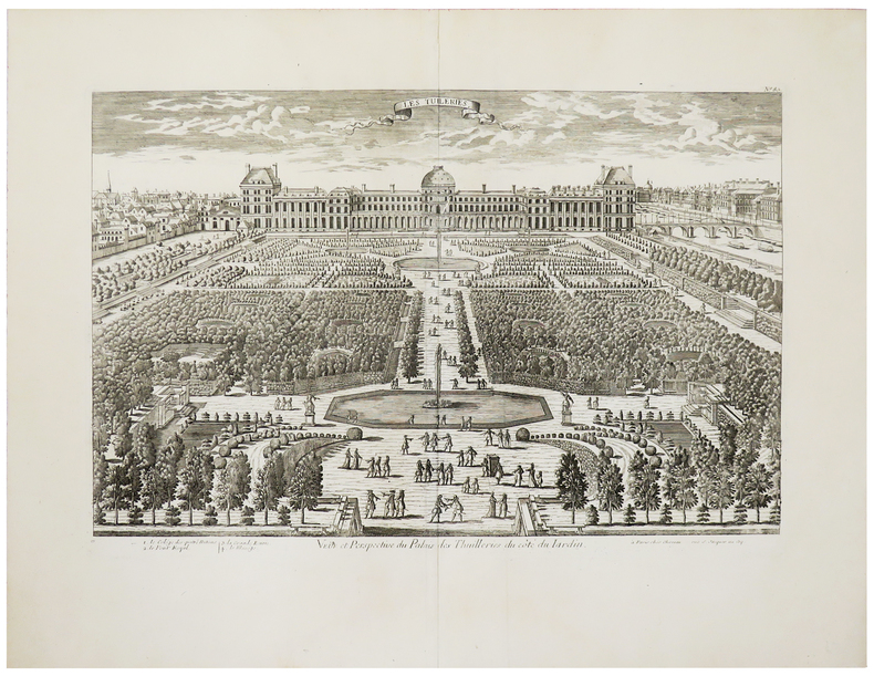
CHÉREAU (Jacques).
[JARDIN des TUILERIES] Veüe et perspective du Palais des Thuilleries du côté du jardin.
Paris, Chéreau, [circa 1760]. 344 x 515 mm.
Bookseller reference : LBW-961
|
|
|
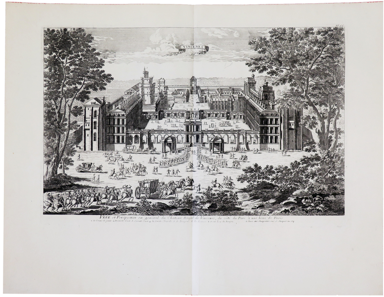
CHÉREAU (Jacques).
[VINCENNES] Veüe et perspective en général du château royal de Vincenes, du côté du parc à une lieüe de Paris.
Paris, Charpentier, [circa 1760]. 333 x 511 mm.
Bookseller reference : LBW-622
|
|
|
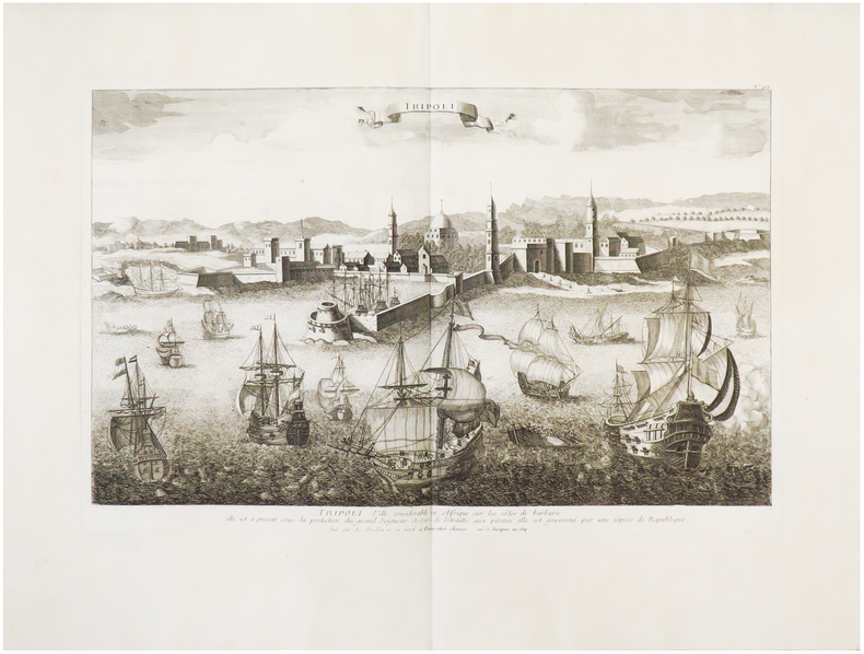
CHÉREAU (Jacques).
Tripoli.
Paris, Chéreau, [circa 1760]. 336 x 510 mm.
Bookseller reference : LBW-575
|
|
|
CHÉREAU (Jacques).
Veue de la cour des fontaines de Fontaine Beleau.
Paris, Chéreau, [circa 1760]. 367 x 484 mm.
Bookseller reference : LBW-624

|
|
|
CHÉREAU (Jacques).
Veüe du chasteau de Meudon du côté de l'entré.
Paris, Charpentier, [circa 1760]. 336 x 516 mm.
Bookseller reference : LBW-623
|
|
|
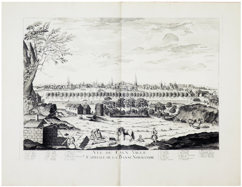
CHÉREAU (Jacques).
Vue de Caen, ville capitale de la Basse Normandie.
[Paris, Chéreau, circa 1760]. 383 x 525 mm.
Bookseller reference : LBW-460
|
|
|
CHÉREAU (Jacques).
Vüe et perspective du château de Chantilly du côté de la cour.
Paris, Charpentier, [circa 1760]. 340 x 510 mm.
Bookseller reference : LBW-425
|
|
|
CHÉREAU (Jacques);
[CHAMBORD] Vüe de Chambor.
Paris Charpentier 1760 circa 338 x 505 mm.
Bookseller reference : LBW-416

|
|
|
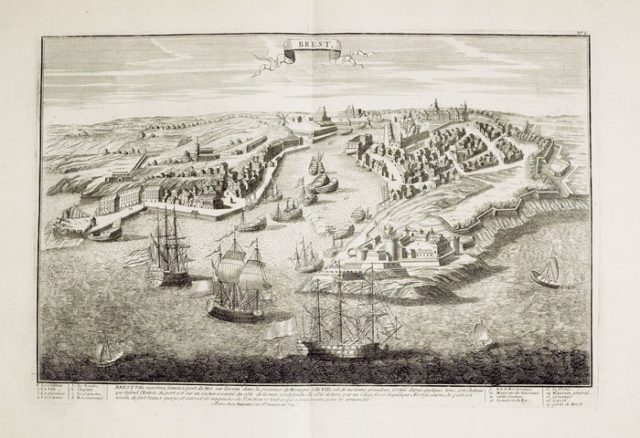
CHÉREAU (Jacques);
Brest.
Paris Charpentier 1760 circa 342 x 508 mm.
Bookseller reference : LBW-461
|
|
|
CHÉREAU (Jacques);
Elévation et perspective de l'église cathédrale de St. Paul de Londres vuë de côté.
Paris Chéreau 1761 344 x 531 mm.
Bookseller reference : LBW-686
|
|
|
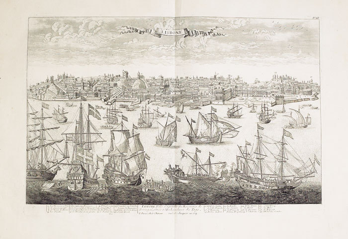
CHÉREAU (Jacques);
Lisbone ville capitale du royaume de Portugal située à l'embouchure du Tage.
Paris Chéreau 1760 circa 346 x 515 mm.
Bookseller reference : LBW-517
|
|
|
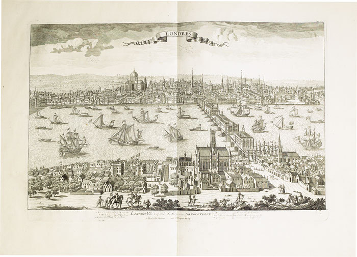
CHÉREAU (Jacques);
Londres ville capital du royaume d'Angleterre.
1760 circa 342 x 516 mm.
Bookseller reference : LBW-685
|
|
|
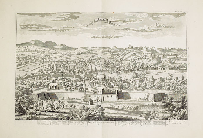
CHÉREAU (Jacques);
Lyon, ville capitale de la province et du gouvernem.t général du Lyonois.
Paris Chéreau 1760 circa 340 x 512 mm.
Bookseller reference : LBW-434
|
|
|
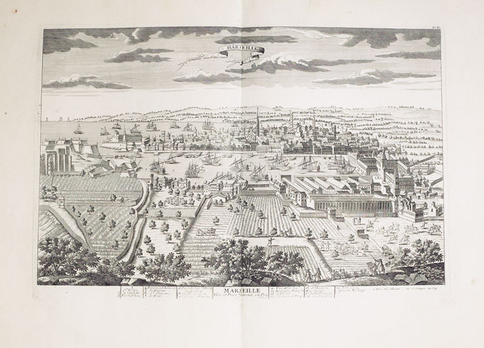
CHÉREAU (Jacques);
Marseille, ville et port fameux en Provence.
Paris Chéreau 1760 circa 342 x 512 mm.
Bookseller reference : LBW-495
|
|
|
CHÉREAU (Veuve).
[NAPOLÉON] Bivouac des troupes russes aux Champs Elisées à Paris au 31 mars 1814.
Paris, Ve Chéreau, [circa 1814]. 285 x 378 mm.
Bookseller reference : LBW-2955

|
|
|
Cimok, Fatih
Biblical Anatolia: From Genesis to the Councils
Book is in excellent condition. Binding is solid and square, covers have sharp corners, exterior shows no blemishes, text/interior is clean and free of marking of any kind. 203 pages with color illustrations throughout.
|
|
|
Cioculescu Serban; Marinache V. Maps by; et. al
Romania - A Guidebook
Bucharest: Meridiane Publishing House 1967. First edition. Hardcover. Near Fine/near fine. First Edition. c.1967. Hardcover. 12mo. 492pp. Large fold-out map in rear. Near Fine in Near Fine dustjacket. Mild general shelfwear light offsetting to endpapers. Meridiane Publishing House hardcover
Bookseller reference : C000019619
|
|
|
CIRAGE LION NOIR.-
Jeu publicitaire de cartes miniatures.-
Le Lion Noir. S. d.- Jeu miniature (34 x 49mm) de 31 cartes sur 32, (la dame de trèfle manque), publicité au dos. Très bon état.
Bookseller reference : ORD-2315
|
|
|
CIRIONI A
AH! LES BEAUX ENFANTS- CARTES POSTALES ANCIENNES- ANTIQUITE BROCANTE
LVA. 2006. In-4. Broché. Etat d'usage, Couv. légèrement passée, Dos satisfaisant, Intérieur frais. 119 pages d'illustrations en monochrome dans le texte (légendes). . . . Classification Dewey : 741.68-Illustrations des cartes postales
Bookseller reference : R200052064 ISBN : 284567354
|
|
|
Cityscape Maps Limited
Glasgow City Map and Guide
2008-02-09. Good. Ships with Tracking Number! INTERNATIONAL WORLDWIDE Shipping available. May not contain Access Codes or Supplements. May be re-issue. May be ex-library. Shipping & Handling by region. Buy with confidence excellent customer service! unknown
Bookseller reference : 186080067X ISBN : 186080067x 9781860800672

|
|
|
Cityscape Maps Limited
York City Map and Guide
2009-01-30. Good. Ships with Tracking Number! INTERNATIONAL WORLDWIDE Shipping available. May not contain Access Codes or Supplements. May be re-issue. May be ex-library. Shipping & Handling by region. Buy with confidence excellent customer service! unknown
Bookseller reference : 1860801498 ISBN : 1860801498 9781860801495

|
|
|
CIVIL WAR MAPS
The American Annual Cyclopedia and Register of Important Events of the Year 1863.
New York.: Appleton & Company. 1865. Three-quarter leather-bound volume 10 x 7 inches; 865 pp. Corners bumped and abraded; front cover hinges loose with one external tape repair; light damp stain in bottom margin and along front free edge throughout not impacting text. In the entry "Army Operations" six full-page maps and additional in-text maps document Civil War engagements. The six full page maps signed "WATERS - SON SC NY" Charles J.B. Waters and John W. Waters are strong detailed impressions. The "Waters - Son" signature is associated with a variety of mid-19th century maps of Western America. The 1865 edition is an especially important volume in the Appleton series. The volume provides coverage of an extensive list of topics; perhaps most interesting are the entries relating to the Civil War: "Army Confederate"; "Army of the United States"; "Army Operations"; "Confederate States"; "Draft Riots in New York Boston and Elsewhere." The Editors write in the Preface that the volume includes "A detailed statement of the vast military and naval operations in this country…; also the efforts of the Government to improve the condition of the freedmen who came within their control and to organize the able-bodied as soldiers; also the plans and arrangements of its immense hospitals for the sick and wounded. The military operations are illustrated with complete topographical maps of the country." Overall a valuable volume with emphasis including maps on the unfolding events of the Civil War. Condition issues noted. . Appleton & Company. hardcover
Bookseller reference : 51881

|
|
|
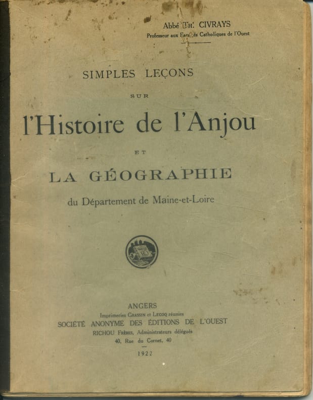
CIVRAYS Th. (Abbé) Illustré, cartes hors texte.
Simples leçons sur l'histoire de l'Anjou et la géographie du département de Maine-et-Loire.
Couverture souple. Broché. 96 pages. Légèrement défraîchi. Rousseurs. Réparation à la carte de l'Anjou.
Bookseller reference : 141712
|
|
|
CLAPHAM H
Monte Carlo up to Date. With four entirely original methods of play, the only ones that can succeed under the present changed rules.
Slnd, in8br, 48pp , mouillures sur la couverture et quelques pages.
Bookseller reference : M5094
|
|
|
Clapp Nicholas line drawings and maps by Kristen Mellon Dust Wrapper design by Beth Middleworth author photo by David Maltzer
SHEBA: THROUGH THE DESERT IN SEARCH OF THE LEGENDARY QUEEN
Boston / New York: Houghton Mifflin Company. Near Fine in Near Fine dust jacket. 2001. First Edition. Hardcover. 0395952832 . First edition. This copy has been signed by the author who has also printed three non-English characters above his signature on the half-title page. "Three thousand years ago a dusky qaueen swept into the court of King Solomon and from that time to the present day her tale has been told and retold. Who was this queen Did she really exist". 372 pages illustrated with photographs drawings and maps appendices: the name of Sheba chronology of the Sabean Sheban state demon Sheba alchemical Sheba; notes bibliography acknowledgments illustration credits index. Near Fine copy upper corner fold to two consecutive leaves in Near Fine Dust Wrapper with "Autographed COPY" sticker affixed to the front panel.; Signed by Author . Houghton Mifflin Company hardcover
Bookseller reference : 56351 ISBN : 0395952832 9780395952832

|
|
|
Clarence Edwin editor/compiler Carter; Illustrator bw maps
Territorial Papers of the United States: The Territory of Alabama 1817-1819 vol. 18
Government Printing Office 1952. Hardcover. Very Good. xiii 875 p.; 26 cm. Blue cloth. Good binding and cover. Clean unmarked pages. Government Printing Office hardcover
Bookseller reference : 1204090009
|
|
|
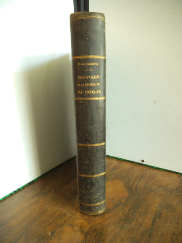
CLARETIE Jules
Histoire de la Révolution de 1870-1871.
Histoire de la Révolution de 1870-1871. Chute de l’Empire- La guerre- Le gouvernement de défense nationale- La paix- le siège de Paris- La Commune de Paris ; Un volume in 8 290x200mm. demi-cuir vert, faux-titre, portrait de l’auteur en frontispice, titre, 796 pages, texte sur 2 colonnes nombreuses illustrations dans le texte et à pleine page, scènes, portraits, cartes, plans, autographes, Aux bureaux du journal l’Eclipse 1872.
Bookseller reference : 13438
|
|
|
Claude Couraud
Je me souviens du 12e arrondissement.
Parigramme (1 avril 2001) Collection : Je me souviens. - In-4 carré 24,4 x 22,6 cm, reliure éditeur, dos toilé noir imprimé en blanc, plats imprimés, 120 pages, richement illustré de photographies en noir et blanc. Très bon état, comme neuf.
Bookseller reference : 22380

|
|
|
CLAYE
Carte au 1/20 000?me. Fin XIXe.
Une feuille. 64x46 cm.
|
|
|
Clear View Maps Ltd.
Street Map of Winnipeg
Calgary AB: Clear-View Maps Ltd. N.D. Circa 1989. Stapled Wraps. pp. 58. 12mo. Card covers. Predominantly black and white maps with one colour fold-out map affixed to verso rear cover. Light edgewear scuffing to covers which are detatched but present contents remain clean and unmarked; good. <br/><br/> Clear-View Maps Ltd. paperback
Bookseller reference : 054234
|
|
|
CLERC-RAMPAL G.; BERGET A. (préf.):
La mer. La mer dans la nature. La mer et l’homme.
Paris, Lib. Larousse, 1930. 1 vol. in-4 de VIII, 302, [1 f.] p. Demi-chagrin marron, dos lisse orné, plats de percaline verte ornés à froid. Coins inférieurs frottés, belle condition générale.
Bookseller reference : 2818

|
|
|
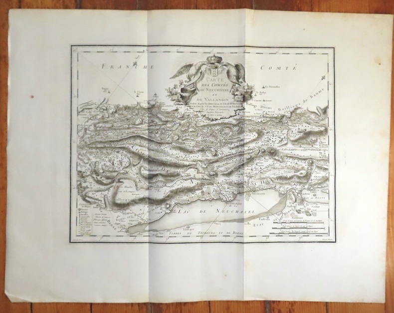
Clermont, De Merveilleux, Beauvoir (sript.), Perrier (grav.):
Carte des Comtés de Neuchâtel et de Vallangin. Dressée d'après les observations de l'Académie Royale des Sciences et la carte de D. F. de Merveilleux de Neuchâtel par le Sieur Clermont.
1779. Carte au format 65 x 49 (feuille). Quelques rousseurs dans les marges, pliée en 3.
Bookseller reference : 20234
|
|
|
CLEVELEY (John) & PIRINGER (Benedikt).
[HAWAÏ] Mort du capitaine Cook.
Paris, Bance ainé, [circa 1800]. 465 x 601 mm.
Bookseller reference : LBW-8199

|
|
|
Clifford Hugh. Bartholomew J. G. Maps by. Crocco M. Di Preface
FURTHER INDIA. Being the Story of Exporation from the Earliest Times in Burma Malaya Siam and Indo- China
Bankok: White Lotus Co 1990. 1st Edition. Illustrated laminated wrappers with black title lettering printed to front wrapper and spine. Last page is dog-eared PO stamp to preliminary title page. A VG copy. xi 1 blank 378 2 pp including appendix. Many b/w illustrations and maps. One fold-out image. 8-1/2" x 6" <br/><br/> White Lotus Co unknown
Bookseller reference : 34882

|
|
|
Clifford Hugh. Bartholomew J. G. Maps by. Crocco M. Di Preface
FURTHER INDIA. Being the Story of Exporation from the Earliest Times in Burma Malaya Siam and Indo- China
Bankok: White Lotus Co 1990. 1st Edition. Illustrated laminated wrappers with black title lettering printed to front wrapper and spine. Last page is dog-eared PO stamp to preliminary title page. A VG copy. xi 1 blank 378 2 pp including appendix. Many b/w illustrations and maps. One fold-out image. 8-1/2" x 6" <br/><br/> White Lotus Co unknown books
Bookseller reference : 34882
|
|
|
CLOT-BEY A.-B. [Antoine Barthélémy]:
Aperçu général sur l'Egypte.
Paris, Fortin, Masson et Cie, 1840. 2 volumes in-8 de [4]-360-[2]-6 (catalogue) et [8]-570-[2] pages, demi-chagrin noir, dos à 4 petits nerfs avec titre et tomaison dorés et encadrements à froid, tranches mouchetées. Reliure un peu frottée, rares rousseurs, tampon répété aux pages de titre et sur ff. vierges.
Bookseller reference : 10343

|
|
|
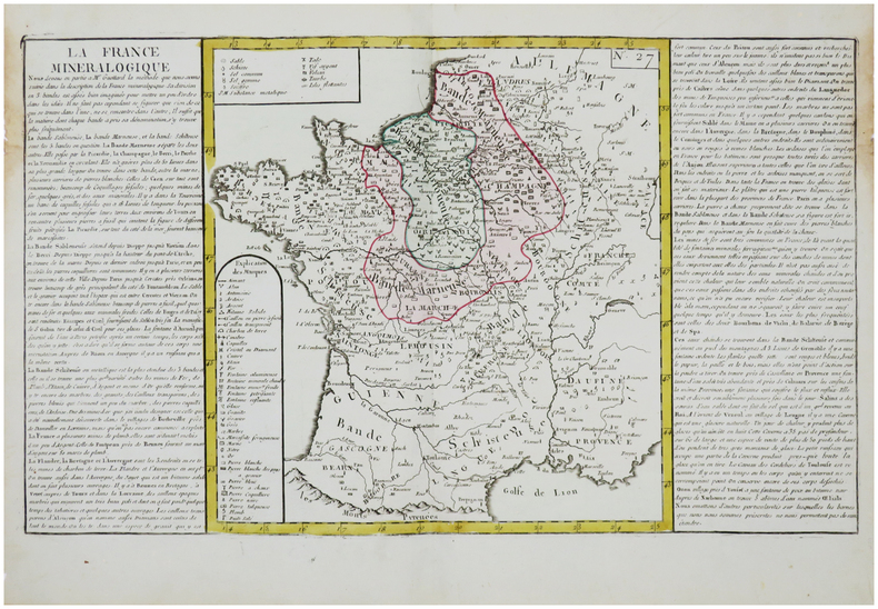
CLOUET (Jean-Baptiste Louis, l'abbé).
[MINÉRALOGIE] La France minéralogique.
[Paris, Mondhare, circa 1790]. 320 x 550 mm.
Bookseller reference : LBW-7581
|
|
|
CLOUET Jean Baptiste Louis L'Abbe (Attivo intorno al 1760)
Mappamonde ou Globe Terrestre
Primo stato di questa non comune carta del mondo del XVIII secolo, successivamente ristampata nel 1775 e 1787. La carta mostra le numerose esplorazioni del secolo ed è altamente decorativa. La carta è largamente più conosciuta per la sua comune ristampa del 1787, curata dall'editore Louis Joseph Mondhare, che raffigura la scoperta delle Hawaii (Isole Sandwich o Why, come indicato sulla mappa), le esplorazioni nella costa nord-occidentale dell'America e quelle dei viaggi di Cook (1773,1775, 1776, 1777, 1777, 1778), Jean Baptiste Louis Clouet era membro dell'Accademie Royale des Sciences di Rouen e fu autore della Geographie Moderne (1767). Acquaforte, in ottimo stato di conservazione. Magnifico esemplare in piena coloritura coeva. First state of this uncommon World map with the major 18th century explorers. Rare separately published double hemisphere map of the world, issued by Clouet in Paris. The map is largerly known for his second and common issue by Louis Joseph Mondhare (1787) showing the discovery of Hawaii (Ile Sandwich ou Why, as named on the map) and explorations in the Northwest Coast of America are quite prominent, and the major 18th century explorers like Cook (1773,1775, 1776, 1777, 1778). Jean Baptiste Louis Clouet (born 1730) was a member of the Academie Royale des Sciences de Rouen and the author of Geographie Moderne (1767). Etching with full contemporary colour, very good conditions.

|
|
|
Clouet, Jean-Baptiste-Louis (1730-17..?). Auteur du texte
LA FRANCE MINERALOGIQUE [Document cartographique] 1771
Paris 1780 carte ancienne colorée d'époque en vert et jaune. Format total : 39 centimètres de haut par 55 centimètres de large, [S.l.] : [s.n.], [s.d.] (1780) d'après la méthode de Guettard ,
Bookseller reference : 27406
|
|
|
CLOUÉ (Georges-Charles).
[LA RÉUNION] Carte des côtes de l'île de La Réunion.
[Paris], Dépôt-Général de la Marine, 1849. 612 x 886 mm.
Bookseller reference : LBW-8266

|
|
|
CLOVIS par Michel ROUCHE.
Clovis. Etude suivie de 21 documents traduits et commentés (lettre de Remi à Clovis, extraits de la Vie de sainte Geneviève, les Francs vus par Procope ...) Documenté (planches en couleurs, cartes).
Ed. Fayard 1996. Bel exemplaire relié, couverture ornée d'éd., fort in-8, 612 pages avec annexes dont index + planches.
Bookseller reference : AUB-6005
|
|
|
CLUB D"HISTOIRE DU COLLEGE RENE GOSCINNY.
VAIRES-SUR-MARNE DE 1914 à 1939
editions Amatteis, 1987, un volume in 8 broché, 319 pages, 170 photos, illustrations, reproductions de documents, reproductions de cartes postales anciennes. Numerote sans justification de tirage. Petites traces de pliure peu prononcées aux coins inférieurs de la couverture, sinon bon état.
Bookseller reference : 6396
|
|
|
Cluver Philippe Philipp Cluverius / Cluvier Buno Johann ; Reiske Johann ; Heckel Johann Friedrich
Philippi Cluverii Introductio in universam geographiam tam veterem quam novam. Tabulis geographicis XLVI ac notis olim ornata a Johanne Bunone jam vero locupletata additamentis & annotationibus Joh. Frid. Hekelii & Joh. Reiskii. Cum privilegio ordinum Ho
Amsterdam: Jean Wolters 1697. Livre. Bon. Plein V�lin. First Thus. Petit In-4. Amsterdam Amstelaedami Jean Wolters Joannem Wolters 1697. 24 x 18 cm R in-4 1 f. bl. - titre frontispice enti�rement grav� - 11 ff. n. ch. dont titre d�dicace adresse au lecteur epistolae table et privil�ge - 565 pp. - 31 ff. n. ch. d'index - 2 ff. bl. - 2 planches 3 tableaux et 41 sur 43 cartes grav�es hors texte dont 40 sont d�pliantes ou � double page reliure hollandaise de l'�poque en plein v�lin dor� plats estamp�s � froid de motifs des Pays Bas espagnols dans un double encadrement de filets avec fleurons d'angle dos estamp� de filets et fleurons titre manuscrit � l'�poque traces de lacets. sig. 3 4 4 A-Z4 Aa-Zz4 Aaa-Zzz4 Aaaa-Kkkk4 Belle �dition de la fin du XVIIeme du c�l�bre atlas de Cl�ver avec les commentaires de Buno Reiske et Heckel int�ressante notamment parce qu'elle est au format in-4 et non in-8 ou in-12 comme la plupart des autres. Un bel ex-dono dat� de 1725 et couvrant tout le premier feuillet blanc nous indique qu'il s'agit d'un livre de prix. Cachets annul�s d'une biblioth�que de capucins au titre. Sans la mappemonde et la carte l'Am�rique. Exemplaire tr�s l�g�rement d�r�gl� ce qui est courant pour un volume de cette taille une carte d�tach�e pour le reste un fort bel exemplaire exempt de rousseurs et dans une belle reliure estamp�e de l'�poque. dv. Jean Wolters Hardcover
Bookseller reference : 1181

|
|
|
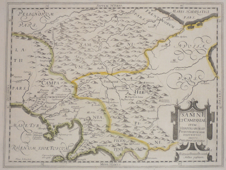
CLUVER (Philippe).
[CAMPANIE] Samni, et Campaniae, item Hirpinorum et Picentinorum agri descriptio.
[1624]. 206 x 273 mm.
Bookseller reference : LBW002a9
|
|
|
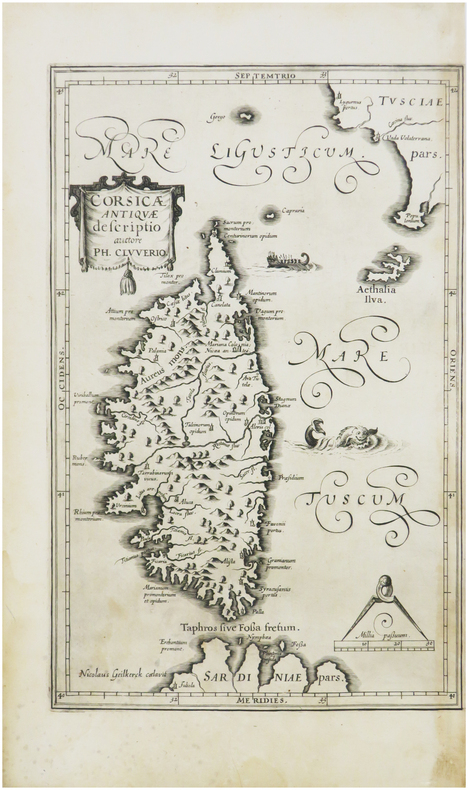
CLUVER (Philippe).
[CORSE] Corsicæ antiquæ descriptio. Auctore Ph. Cluverio.
[1619]. 285 x 181 mm.
Bookseller reference : LBW-8110
|
|
|
CLUVERIUS, Philippus (1580-1623) (CLUVER):
Germania antiqua. Cum vindelicia et Norico auctoris methodo, verbis & tabulis Geogr. retentis contracta opera Johannis Bunonis acc. index rerum...
Gvelferbyti Sumtibus Conradi Bunonis, Typis Johan. Henr. Dunckeri, (Wolfenbüttel, C. Buno), 1663 in-4to, 34 Bl. + 752 S. + 59 Bl. (Index). Mit 6 (5 gefalt.) Kupfertafeln und 10 gefalt. Karten, Original-Lederband d. Zt. (Bezug etwas brüchig, mit kl. Fehlstellen, etwas best.).
Bookseller reference : 120052aaf
|
|
|
Clyde James
SCHOOL GEOGRAPHY
Edinburgh: Oliver and Boyd 1886. "Revised throughout and partly recast. With Nine Maps" pp. 551 24 pages of adverts 9 colour folding maps. Original brown cloth binding with gilt lettering very good and bright with slight wear only. Contents clean and tight small neat signature dated 16.10.87 to front end paper otherwise no inscriptions. A very good to fine copy. Twenty-third Edition. Hard Cover. Very Good. 8vo 12 X 18cm. Oliver and Boyd Hardcover
Bookseller reference : 010484
|
|
|
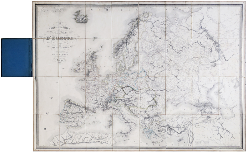
CLÉROT (Victor).
[POSTES] Carte générale de toutes les routes de postes d'Europe.
Paris, Victor Clérot, 1855. En 32 sections montées sur toile et pliées, formant une carte de 0,97 x 1,37 m ; montée dans une reliure en demi-chagrin bleu nuit avec titre en lettres dorées sur le premier plat.
Bookseller reference : LBW-6418
|
|
|
COASTAL SURVEY MAPS
Sketches Accompanying the Annual Report of the Superintendent of the United States Coast Survey 1851. 32nd Congress 2d Session. Ex. Doc. No. 3.
Washington D.C.: United States Coast Survey. 1851. 58 black and white folding charts maps and diagrams map no. 25 not bound in embossed gilt lettered cloth covered boards hardbound11 1/2 x 9 1/2 inches. Covers rubbed and lightly soiled cloth spine missing now replaced with reinforcing cloth tape; label to front paste-down "With the compliments of A.D. Bache". The first four large folding charts each have a repaired tear from the lower gutter edge and some separations at folds several of which are long; the large charts later in the volume apparently were subject to less handling and are intact. All are clean and bright. A collection of charts maps and diagrams of varying sizes including locations on both east and west coasts. Included are: "Chart exhibiting the course and velocity of ebb current in Boston Harbour" "Holmes's Hole" "Preliminary sketch of Hatteras inlet" "Showing the progress of the survey at Cedar Keys Bahia Honda Key Biscayne Key West and Dry Tortugas" "Preliminary sketch of Galveston bay" "Reconnoissance of the western coast No.1 with view of Point Pinos" "San Diego entrance and general sketch of San Diego bay" 3 sheets showing the "Reconnoissance of the western coast" "Mouth of the Columbia River" etc. The map number 25 Sketch E No. 6 of Bull's bay was apparently never bound in but has been loosely laid in. . United States Coast Survey. hardcover
Bookseller reference : 46065

|
|
 Receive by email
 Download as PDF document
 RSS feed


