|
Israel Maps:
Midrich Israel Folder of 7 Map Booklets 1:100000
Israel 1980's Plastic Folder 7 Booklets of Maps Street names etc in Hebrew. Seperate large Folded map. Good Israel, 1980's unknown
Bookseller reference : 71113
|
|
|
ISRAEL OG PALAESTINA -
Iudaea eller helige landet, The tolf Slächters indeelning uthi Iuda och Israels Riken.
(Stockholm, 1703). (41 x 53 cm.). Kobberstukket kort over Israel og Palæstina etc. med den Arabiske ørken i øst. Med stor kartouche. I passpartou.
Bookseller reference : 53194
|
|
|
ISRAEL OG PALAESTINA -
Iudaea eller helige landet, The tolf Slächters indeelning uthi Iuda och Israels Riken.
(Stockholm, 1703). (41 x 53 cm.). Kobberstukket kort over Israel og Palæstina etc. med den Arabiske ørken i øst. Med stor kartouche. I passpartou.
|
|
|
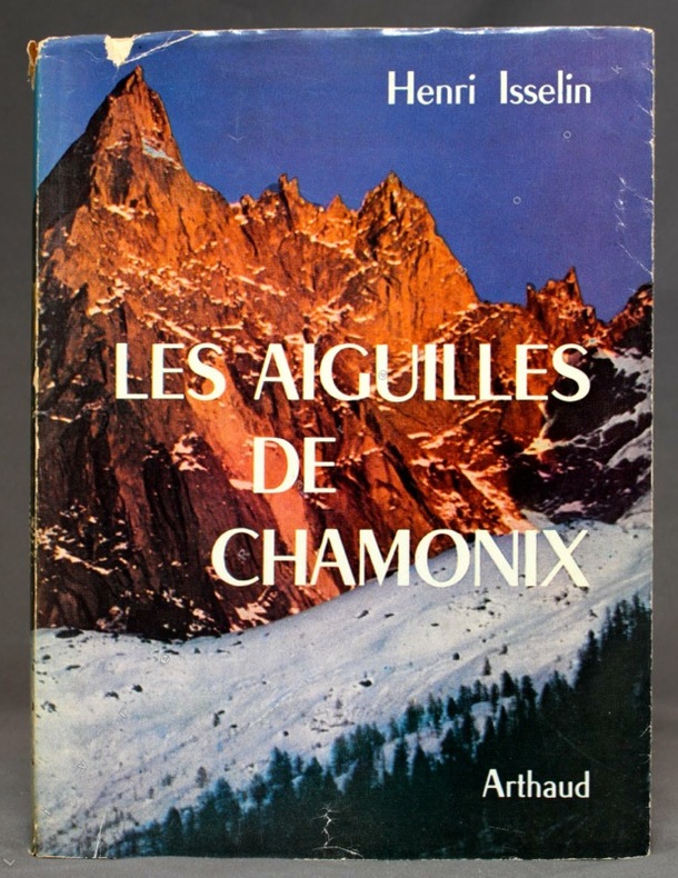
ISSELIN Henri:
Les Aiguilles de Chamonix.
Sans lieu, Arthaud, coll. Sempervivum 37, 1961. In-8 broché de 261-[11] pages, couverture imprimée sous jaquette photographique couleurs (avec 3 petits accrocs). Nom de possesseur.
Bookseller reference : 10673
|
|
|
Isserman Maurice and Stewart Weaver; maps and peak sketches Dee Molenaar
The Conquest of the Himalayas. A History of Himalayan Mountaineering from the Age of Empire to the Age of Extremes
<p>New Haven: Yale University Press 2008. first printing. Hardcover. Very Good/fine. xii 579p illustrations 26cm tall quarto. Rear board has light soil.</p> Yale University Press hardcover
Bookseller reference : 00004456 ISBN : 0300115016 9780300115017

|
|
|
ITALIE ILLUSTREE par P. JOUSSET.
L'Italie illustrée. 14 cartes et plans en couleurs, 9 cartes en noir, 12 planches hors texte, 784 photos.
Paris, éd. Larousse s.d. (vers 1920). Bon exemplaire relié, relieure demi cuir d'éd., fort in-4, 371 pages + planches.
Bookseller reference : AUB-4181
|
|
|
ITALY HISTORICAL MAPS Macpherson WW. mapmaker. Cooper engraver. W. W.
Italia in Regiones Undecim ab Augusto descripta cum Insulis Corsica et Sardinia; cura et studio D. Macpherson. SET OF FIVE MAPS.
London.: Longman Hurst Rees and Orme. 1805- 1807. SET OF FIVE black and white copperplate engraved maps centrefold as issued each approximately 10 x 15 3/4 inches on sheet size 10 1/2 x 16 inches. Paper loss to outer margins from insect damage mainly outside neat line light toning to paper mainly along centerfold and outer edges. Five maps include: "Italia in Regiones Undecim ab Augusto descripta cum Insulis Corsica et Sardinia" "Italia Media vet Italie Propriae pars Borealis ante divisionem ab Augusto factam" "Italia Ulterior cujus pars australis Magna Graecia ob Graecorum colonias dicta ante divisionem ab Augusto factam" "Sicilia Provincia Romanorum cum Insulis Adjacentibus" and "Italiae Regio Alpina quae vulgo sed minus recte dicitur Gallia Cisalpina". From Rees' Encyclopedia. . Longman, Hurst, Rees, and Orme. unknown
Bookseller reference : 44442

|
|
|
ITM Canada International Travel Maps Illustrator
Australia 1:3.5M Travel Map
ITMB Publishing Ltd 2010-12-30. 6. Map. Good. ITMB Publishing Ltd unknown
Bookseller reference : SONG1553411218 ISBN : 1553411218 9781553411215
|
|
|
ITM Canada International Travel Maps Editor
Sahara 1:3.85M Travel Map Travel Reference Map
Itmb Publishing Ltd 2006-08-01. 2. Map. Used:Good. Itmb Publishing, Ltd unknown
Bookseller reference : DADAX155341022X ISBN : 155341022X 9781553410225

|
|
|
ITM Canada; Editor International Travel Maps
Sahara 1:3.85M Travel Map Travel Reference Map
Itmb Publishing Ltd 2006-08-01. Map. Good. Itmb Publishing, Ltd unknown
Bookseller reference : SONG155341022X ISBN : 155341022X 9781553410225
|
|
|
ITMB International Travel Maps
Mekong Delta/Southern Vietnam Travel Reference Map: 1:500000
ITMB International Travel Maps 2007. Map. New. 2nd edition. 2 pages. 9.90x4.00x0.40 inches. ITMB International Travel Maps unknown
Bookseller reference : __1553415876 ISBN : 1553415876 9781553415879

|
|
|
ITMB International Travel Maps
Mekong Delta/Southern Vietnam Travel Reference Map: 1:500000
ITMB International Travel Maps 2007. Map. New. 2nd edition. 2 pages. 9.90x4.00x0.40 inches. ITMB International Travel Maps unknown
Bookseller reference : 2-1553415876 ISBN : 1553415876 9781553415879
|
|
|
ITMB Publishing International Travel Maps Editor
Jasper National Park Map by ITMB Travel Reference Map
ITMB Publishing 2000-01-01. 1. Map. Used:Good. ITMB Publishing unknown
Bookseller reference : DADAX1895907691 ISBN : 1895907691 9781895907698

|
|
|
Ivan T Sanderson text maps charts and illustrated by F Wenderoth Saunders
FOLLOW THE WHALE
Cassell & Co publishers London - first UK edition 1958 hardcover 5�" x 8�" with dust jacket Ours is an ex-library copy in transparent protective covering with usual stamps stickers barcode etc. GOOD book in GOOD price-clipped dust jacket Eleven major maps appendices 30-pages with Whaling Chronology Evolution of Whale Tails Comparative Sizes and illustrated list of Living Whales; plus Bibliography by Periods and Subjects; and Index. To follow the whale is to follow the whole course of one of the most important aspects of human history. It is virtually the story of the conquest of our planet Earth; a history in which man is almost anonymous. Here is the triumph of the puny and of the twilight of the mighty. Excellent history! Cassell & Co, publishers, London - first UK edition hardcover
Bookseller reference : 35025
|
|
|
Ivanoff Jacques Lejard Thiery
Mergui et les Limbes de L'archipel Oublie: Impressions observations et description de quelques îles au large du Ténasserim
White Lotus Co Ltd 2001 246 pages 20 8x2x29 2cm. 2001. Broché. 246 pages.
Bookseller reference : 500133231

|
|
|
J. & C. WALKER (Engraved by).
[MAP of TURKEY in EUROPE] Turkey I; Containing the Northern provinces. Published under the Superintendence of the Society for the diffusion of useful knowledge. Engraved by J. & C. Walker.
Very Good English Original map. Oblong folio. (36 x 43 cm). In English. [MAP of TURKEY in EUROPE] Turkey I; Containing the Northern provinces. Published under the Superintendence of the Society for the diffusion of useful knowledge. Engraved by J. & C. Walker. It shows Turkish / Ottoman provinces in Europe from Thrace to the southern borders of Hungary, Bessarabia and Transylvania at north, Adriatic shores at west, Black Sea coasts at east including Croatia, Hertsek, Zwornik, Semendri, Ieni Bazar, Krukhovatz, Widdin, Nikopoli, Wallachia, Sophia, Chirman, Kirkliseh, Wisa, Gallipoli, Ghiustendil, Skitari Ochrida, etc. A very detailed map.
|
|
|
J. & R. Baker Matson; Illustrator Maps b & w Photos
Mammals of Zacatecas Special Publications
Texas Tech University Press 1986-01-15. Hardcover. Good. Interior clean binding tight light wear to covers. No dust jacket. Texas Tech University Press hardcover
Bookseller reference : 0896721442isbn ISBN : 0896721442 9780896721449
|
|
|
J. & R. Baker Matson; Illustrator Maps b & w Photos
Mammals of Zacatecas Special Publications
Texas Tech University Press 1986-01-15. Hardcover. Very Good. Interior clean binding tight light wear to covers and dust jacket although dust jacket has a few slightly worn spots around the edges no chips or tears. Texas Tech University Press hardcover
Bookseller reference : 0896721442isbn2 ISBN : 0896721442 9780896721449
|
|
|
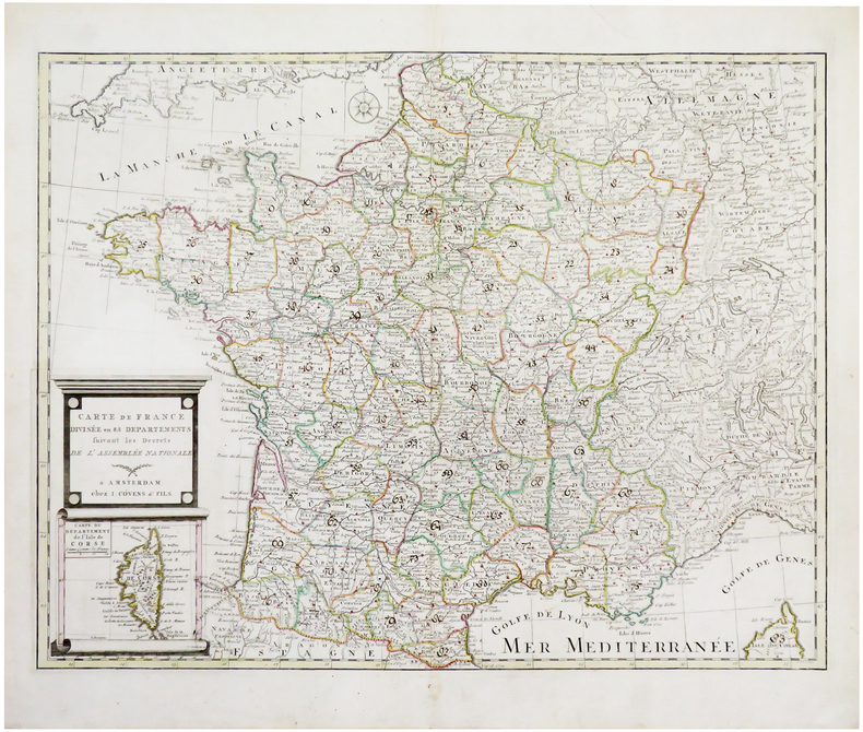
J. COVENS & FILS.
Carte de France divisée en 83 départements suivant les décrets de l'Assemblée Nationale.
Amsterdam, J. Covens & fils, [1791]. 478 x 613 mm.
Bookseller reference : LBW-6668
|
|
|
J. Craighead; Illustrator Maps Photos
A PROPOSED DELINEATION OF CRITICAL GRIZZLY BEAR HABITAT IN THE YELLOWSTONE REGION
Bear Biology Assoc 1980. Paperback. Very Good. Very good softcover book is clean and tight. 20pp Bear Biology Assoc paperback
Bookseller reference : 19474
|
|
|
J. Leonard Raulston James Weston Livingood Photo Plates & Maps Illustrator
Sequatchie: A Story of the Southern Cumberlands
Univ of Tennessee Press 1974-04-01. First Edition. Hardcover. Used:Good. Univ of Tennessee Press hardcover
Bookseller reference : DADAX0870491512 ISBN : 0870491512 9780870491511

|
|
|
J. M. WAGSTAFF.
Geographical studies on modern Turkey and the Ottoman Empire.
New English Paperback. Pbo. Roy. 8vo. (24 x 17 cm). In English. 296 p. Ills. 'Acknowledgements Introduction Modern Turkey 1. (with Brian Beeley) The National Space: Patterns and Potential 2. Turkey's Association with the European Economic Community 3. Turkish Industrialisation: A Geographical Review The Ottoman Empire 4. Ottoman West: Persian East 5. The Ottoman Empire c.1520 6. The Development of a Modern World System 7.The Role of the Eastern Mediterranean (Levant) for the Early Modern World-Economy 1500-1800 Regions of the Ottoman Empire 8.The History of Greece under Ottoman and Venetian Domination 9. War and Settlement in the Morea, 1685-1830 10. (with Elena Frangakis) Settlement Pattern Change in the Morea (Peloponnisos), c. A.D. 1700-1830 11.(with Elena Frangakis-Syrett) Patras and its Hinterland: City Port Development and Regional Change in 19th Century Greece 12.Evliya Çelebi, The Mani and the Fortress of Kelefa 13.Independent Greece: The Search for a Frontier, 1822-35 14.The Mountain and the Plain: Some Themes of Continuity and Change in Palestinian Landscapes 15. Arabia Deserta as Geography 16. The Madra River Delta in the Late Ottoman Period Some Travellers in the Ottoman Empire 17. John Philip Morier's Account of the Mani, 1804 18. Colonel Leake and the Classical Topography of Asia Minor 19. The Contribution of Early Travel Narratives to the Historical Geography of Greece 20. Colonel Leake's View of the Turks'. OTTOMANIA Geography Levant Middle East Mediterranean Turkish Republic.
|
|
|
J. R. R. Tolkien; Edited with an Introduction Commentary Index and Maps by Christopher Tolkien
Unfinished Tales of Numenor and Middle-earth
Boston: Houghton Mifflin 1980. First Printing with complete number row.Near Fine very scant and faint foxing to end pages in a Fine dust jacket. Map attached at rear. Uncommon in such exceptional condition a lovely copy. . First American Edition. Cloth. Near Fine/Fine. 8vo. Houghton Mifflin Hardcover
Bookseller reference : 005434 ISBN : 0395299179 9780395299173

|
|
|
J. R. R. Tolkien; Edited with an Introduction Commentary Index and Maps by Christopher Tolkien
Unfinished Tales of Numenor and Middle-earth
Boston: Houghton Mifflin 1980. First Printing with complete number row.Near Fine very scant and faint foxing to end pages in a Fine dust jacket. Map attached at rear. Uncommon in such exceptional condition a lovely copy. . First American Edition. Cloth. Near Fine/Fine. 8vo. Houghton Mifflin Hardcover books
Bookseller reference : 005434 ISBN : 0395299179 9780395299173
|
|
|
J. Shirley and E Horsfield
The structure and ore deposits of the Carboniferous Limestone of the Eyam district Derbyshire Vol. c Parts 3 & 4 1945.
United Kingdom: Quart. Journ. Geological Soc. 1945. contains large fold-out map. Covers good with some wear rear cover carefully taped. Contents clean and tight no inscriptions. A good copy. First Edition. Paperback. Good/No DJ. 8vo. Quart. Journ. Geological Soc. Paperback
Bookseller reference : 022308

|
|
|
J.TRICART Directeur de laboratoire de géographie de l'Université de Strasbourg et de la revue de géomorphplogie dynamiqueM. ROCHEFORT Agrégé de géographie Assistant à l'Université de Strasbourg
INITIATION AUX TRAVAUX PRATIQUES DE GEOGRAPHIE ( commentaire de cartes )
1652 Broché - 16,5 x 25 - 219 pp - année 1953 - Société d'Edition d'Enseignement Supérieur - illustrations -
Bookseller reference : 14577
|
|
|
Jablonski Edward; maps by Rafael Palacios
a Pictorial History of the World War I Years
Garden City NY: Doubleday 1979. 3rd printing. Hardcover in brown/black boards w silver spine titling; in color-illus book club jacket. VG unmarked; in Good bright jacket w edgewear. . Over 400 photos & maps and authoritative text capture the "war to end all wars." Bright tight clean copy of HB 1st in a book club jacket. <br/><br/>7-1/2 x 10-1/2 317 pp index b/w photos & illus black/blue photos & illus endpaper maps. Doubleday hardcover
Bookseller reference : 33641 ISBN : 0385150083 9780385150088
|
|
|
Jacana Maps
Gids Tot Die Kusgebiede Van Suid- Afrika
Jacana 2007. 1st Edition. Soft cover. Fine. The wraps are slightly shelf rubbed.Internally clean.Tightly bound.The book is in Afrikaans.R.K. Our orders are shipped using tracked courier delivery services. Jacana paperback
Bookseller reference : ue4 ISBN : 1770092153 9781770092150
|
|
|
Jacana Maps Kruger National Park
Kruger National Park - Find St
Jacana Media. Used - Good. Shows some signs of wear and may have some markings on the inside. Jacana Media unknown
Bookseller reference : GRP117464393 ISBN : 1874955247 9781874955245
|
|
|
Jacana Maps
Kruger National Park Visitors' Map Book
Jacana Media. Used - Good. Good condition. A copy that has been read but remains intact. May contain markings such as bookplates stamps limited notes and highlighting or a few light stains. Jacana Media unknown
Bookseller reference : V03J-00040 ISBN : 1919777229 9781919777221
|
|
|
Jacana Maps
Kruger National Park Visitors' Map Book
Jacana Media. Used - Good. Shows some signs of wear and may have some markings on the inside. Jacana Media unknown
Bookseller reference : GRP101943356 ISBN : 1919777229 9781919777221
|
|
|
Jacana Maps
The Magic of Pilanesberg
1995-03-04. Good. Ships with Tracking Number! INTERNATIONAL WORLDWIDE Shipping available. May not contain Access Codes or Supplements. May be re-issue. May be ex-library. Shipping & Handling by region. Buy with confidence excellent customer service! unknown
Bookseller reference : 1874955174 ISBN : 1874955174 9781874955177

|
|
|
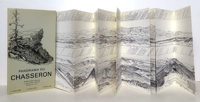
Jaccard Lenoir:
Panorama du Chasseron. Dessiné d'après nature.
[Clup Alpin Suisse], 1964. Leporello au format fermé de 13 x 23,5 cm. - ouvert, de plus de 2 mètres 30.
Bookseller reference : 21691
|
|
|
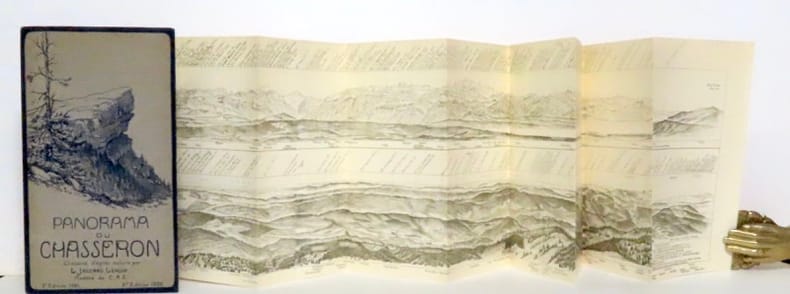
Jaccard Lenoir:
Panorama du Chasseron. Dessiné d'après nature.
[Clup Alpin Suisse], 1936. Leporello au format fermé de 13 x 23,5 cm. - ouvert, de plus de 2 mètres 30.
Bookseller reference : 15918
|
|
|
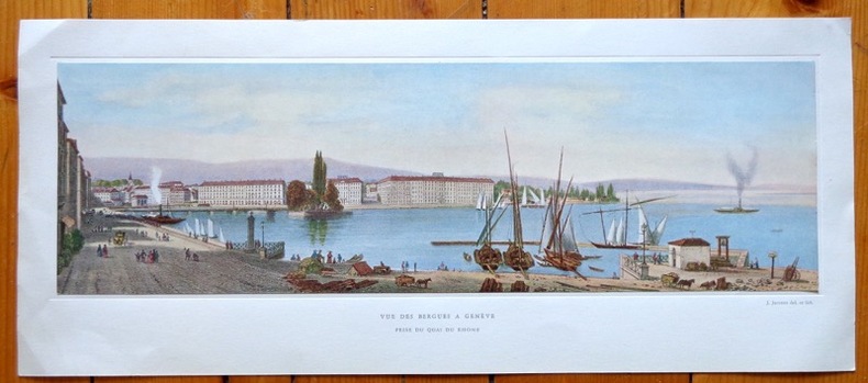
Jaccottet
Vue des Bergues à Genève, prise du quai du Rhône
Jolie reproduction d'une vue de Genève au format 42 x 18 cm (feuille), légendée, contrecollée dans une cuvette. Légères traces de pli aux coins.
Bookseller reference : 641
|
|
|
Jackson Donald editor; Maps & Facsimiles Illustrator
The Journals of Zebulon Montgomery Pike with Letters and Related Documents 2 volumes
University of Oklahoma Press 1966-01-01. First Edition stated. Hardcover. Very Good/No dustjacket as issued. Two volume slipcased set. Both volume have tight bindings and sharp corners. Text and images are unmarked. Fold-out maps are intact. The slipcase has a split in the paper on the top closed edge see photo gently bumped corners and some rubbing. University of Oklahoma Press hardcover
Bookseller reference : CHAPjacZP

|
|
|
Jackson, Peter A.
Maps of Meaning: An Introduction to Cultural Geography
213 pages. "An especially articulate, accessible and comprehensive overview of the renaissance of cultural geography." - Geographical Review. Somewhat above-average wear. Pencil markings to contents. Worthy working copy. Book

|
|
|
JACOB (P.L).
Curiosités de l'histoire des Arts. Notice sur le parchemin et le papier - Recherches sur les cartes à jouer - Origines de l'imprimerie - La Reliure...-Histoire de l'orfévrerie - Les instruments de musique au moyen-age...
1858 in-12, 409pp., br. Paris Delahays 1858,
Bookseller reference : 5764
|
|
|
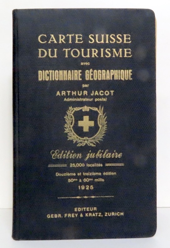
Jacot Arthur:
Carte Suisse du tourisme avec dictionnaire géographique. Edition jubilaire.
Zurich, Frey & Kratz, 1925. In-8, pleine percaline noire avec titre doré, gardes décorées. En belle condition, bien complet des 4 cartes dépliantes insérées en fin de volume.
Bookseller reference : 14318
|
|
|
Jacot Arthur:
Carte Suisse du tourisme avec dictionnaire géographique. 5me édition, entièrement remaniée.
Chez l'auteur (imprimerie Wittmer, Bâle), 1921. In-8, pleine percaline bleue avec titre doré, très très légèrement défraîchie. Bien complet des 4 cartes dépliantes. Tampon au coin de la première carte.
Bookseller reference : 14319

|
|
|
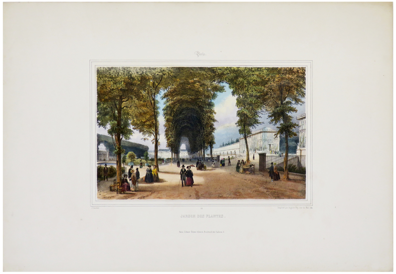
JACOTTET (Louis-Julien).
Jardin des Plantes.
Paris, Gihaut frères éditeurs, [circa 1830]. 210 x 255 mm.
Bookseller reference : LBW-3175
|
|
|
JACOTTET;
TOURS (Indre-et-Loire).
Paris Benard circa 1850 221 x 303 mm.
Bookseller reference : LBW03d66
|
|
|
JACOUBET (Théodore).
Plan de Paris. Extrait du grand Atlas de la ville de Paris en 54 feuilles. Revu et porté jusqu'aux fortifications par P.M. Dalmont Architecte.
Paris, E. et D. Kaeppelin, et la Revue Municipale, 1860. En 32 sections montées sur toile et repliées, formant un plan de 0,98 x 1,29 m.
Bookseller reference : LBW-7971

|
|
|
JACQUEMIN (A.).
[ASSAINISSEMENT] Application des appareils sanitaires.
[fin du XIXe siècle]. Dessin in-folio oblong de 0,63 x 2,09 m, se présentant roulé.
Bookseller reference : LBW-8320

|
|
|
Jacques MILLE, André CHATELON, Christian d'ABOVILLE et Jean-Marc BARFETY
Le DAUPHINE : Une Représentation des Territoires à Partir des Cartes Géographiques Anciennes
Un ouvrage de 336 pages, format 215 x 305 mm, illustré, relié cartonnage couleurs, publié en 2013, Transfaire, bon état
Bookseller reference : LFA-126737050
|
|
|
JACQUES PERVITITCH.
Istanbul in the insurance maps of Jacques Pervititch.= Jacques Pervititch sigorta haritalarinda Istanbul. Project Coord.: Seden Ersoy, Çagatay Anadol.
Fine Fine English Original bdg. with original dust wrapper. DJ. Folio. (39 x 32 cm). In English and Turkish. First Edition. 338 p., 291 ills. in total including b/w and colors: Color ills. of 245 maps (some of them 2 page-sized) and 46 small ills. including some of Constantinople photos and maps. The Pervititch maps that are published in this book should be interpreter from this general point of view. Istanbul realized its modernization in the second half on the 19th century. The frequent fires that occurred in the city were major disasters for its inhabitants, but at the same time created opportunities for the city administrators who intended to push through this modernization. In the aftermath of the 1870 Beyoglu fire, one of the biggest of these fires, a significant change occurered in the realitonship between society and fires. The population of Istanbul became acquainted with insurance that covered fire risks. Numerous insurance companies established branches in Istanbul. Fire insurance became a productive industry. This development turned maps showing the fire risks in the building stock of the city an extremely necessary source of information for insurance companies. Initially, insurance maps were commisioned to the C.E. Goad Company for a rahter limited area of the city between 1904-1906. Later, Jacques Pervititch prepared much more detailed maps covering almost the entire area of the city for the Central Office of Turkish Insurance Agents. Pervititch drew over 230 maps between 1922 and 1945.
|
|
|
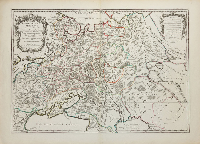
JAILLOT (Alexis-Hubert) & SANSON d'ABBEVILLE (Nicolas).
La Russie blanche ou Moscovie divisée suivant l'estendüe des royaumes, duchés, principautés, provinces et peuples qui sont présentement sous la domination du Czar de Russie, connû sous le nom de grand duc de Moscovie.
Paris, H. Jaillot, 1717. 450 x 645 mm.
Bookseller reference : LBW-2261
|
|
|
JAILLOT (Alexis-Hubert).
[COMMINGES] Le Diocèse de Comminge divisé en ses archiprétrez.
Paris, chez l'auteur, 1700. 600 x 472 mm.
Bookseller reference : LBW-3039

|
|
|
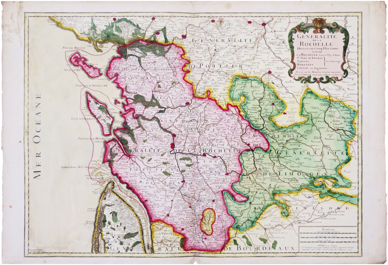
JAILLOT (Alexis-Hubert).
[LA ROCHELLE] Généralité de La Rochelle divisée en cinq élections, sçavoir La Rochelle dans le Pays d'Aunis, Saint Jean-d'Angely, Saintes, Marennes en Saintonge, Cognac en Angoumois.
Paris, chez l'auteur, 1722. 507 x 703 mm.
Bookseller reference : LBW-8035
|
|
|
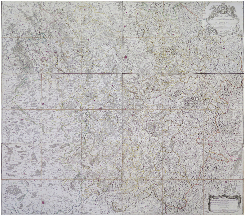
JAILLOT (Alexis-Hubert).
[LORRAINE] Les Estats du duc de Lorraine où sont les duchez de Lorraine et de Bar. Le temporel des éveschez de Metz, Toul et Verdun.
Paris, S.r Jaillot, 1743. En six feuilles coupées en 6 sections montées sur toile et repliées, pouvant être jointes pour former une carte de 1,34 x 1,39 m ; sous étui de suédine de couleur ocre.
Bookseller reference : LBW-8120
|
|
 Receive by email
 Download as PDF document
 RSS feed


