|
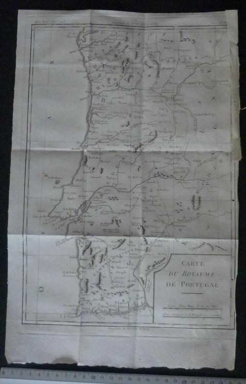
CARTE DU ROYAUME DE Portugal
Carte du Royaume de Portugal (2e moitié du XVIIIe siècle).
1 carte sur papier d'époque 23,5 x 34,3 cm (partie gravée) - Très bel état.
書籍販売業者の参照番号
: 12736
|
|
|
CARTE GEOLOGIQUE DE LA FRANCE.-
Nantua.-
Paris et Liège. Baudry. 1882. Grande et belle carte couleurs (117x62cm) au 1/80000°entoilée, pliage accordéon, avec notice explicative. Rousseurs sur la toile et traces d'humidité, mais assez bon état.
書籍販売業者の参照番号
: ORD-1850
|
|
|
CARTE GÉOLOGIQUE DE LA France
BAYONNE. Carte géologique de la France. Librairie Polytchnique Ch. Béranger. 1905.
1 carte entoilée 62 x 119 cm en couleurs. Carte d'état major. Géologie de la région de Bayonne. Parfait état.
書籍販売業者の参照番号
: 17588

|
|
|
CARTE GÉOLOGIQUE DE LA France
DIGNE. Carte géologique de la France. Librairie Polytchnique Ch. Béranger. 1899.
1 carte entoilée 62 x 119 cm en couleurs. Carte d'état major. Géologie de la région de Digne. Parfait état.
書籍販売業者の参照番号
: 17587

|
|
|
CARTE PORTS ET VILLE DE MALTE
Carte Ports et Ville de Malte extraite de : Victoires, conquêtes, désastres, revers et guerres civiles des Français, de 1792 a 1815 / par une société de militaires et de gens de lettres. Paris : C.L.F. Panckoucke, 1817-1822.
1 carte sur papier chiffon d'époque (vers 1830) 21,40 x 16,60 cm. Très bel état.
書籍販売業者の参照番号
: 13073

|
|
|
CARTE TOPOGRAPHIQUE DE L'ILE DE MALTE
Carte topographique de l'ile de malte (début XIXe siècle).
1 carte sur papier d'époque 15,5 x 25 cm (partie gravée) - Très bel état.
書籍販売業者の参照番号
: 12737

|
|
|
Carte-Guide CAMPBELL N°2.-
NORD.-
Publiée sous le patronage de la Fédération des Automobiles-Clubs régionaux de France. Vers 1916. Grande carte (96x70cm) au 1/320000°. Indication en vert de la ligne du Front au 20 juin 1916.
書籍販売業者の参照番号
: ORD-1851
|
|
|
Cartier Raymond
L'Europa alla conquista dell'America
13 illustrazioni nl testo 38 illustrazioni fuori testo

|
|
|
Cartier Raymond
Le cinquanta Americhe

|
|
|
CARTIER RAYMOND et GROUEFF STEPHANE
L'homme et la mer .
larousse Paris match 1972 bon état 390 pages in 4.
書籍販売業者の参照番号
: 1402
|
|
|
CARTOGRAFIA STRADE AUTOSTRADE FERROVIE
ATLANTE TURISTICO D'ITALIA TCI
CITTA' DA SCOPRIRE - GUIDA AI CENTRI MINORI - VOL 2 ITALIA CENTR. - TOURING CLUB cartografia autostradale 1:800000 cartografia ferroviaria 1:800000 cartografia stradale turistica 1:400000 piante di attraversamento urbane Editore touring club italia Data di stampa 1990 Collana Stato cons. PIU' CHE BUONO Magazzino L041 unknown
書籍販売業者の参照番号
: 232571193184

|
|
|
Cartografia Diafora
Atlas de Andalucia: Geográfico económico-histórico
Diáfora 1981. Unknown Binding. Good. Hardback book no dust jacket in good condition. Diáfora unknown
書籍販売業者の参照番号
: 107672 ISBN : 8485205510 9788485205516
|
|
|
CARTOGRAFIA DE ULTRAMAR CARPETA IV DOS TOMOS
Cartografia De Ultramar. Carpeta IV. America Central Vol 1: Toponimia de Los Mapas Quela Integran y Relaciones historicas De Ultramar Vol 2: mapas. America Central: Guatemala Honduras Nicaragua Costa Rica Panama Cartagena Darien.
Madrid : Servicios Geografico e Historico Del Ejercito 1957. SOFTCOVER . The two vols as originally issued in paperbacks lower ends of spine slightly frayed front cover vol. 2 loosening overall a VERY GOOD set . Madrid : Servicios Geografico e Historico Del Ejercito paperback
書籍販売業者の参照番号
: 200490
|
|
|
Cartografia Everest
Mapa de carreteras de España y Portugal. 1:1.100.000 Mapas de carreteras Spanish Edition
Editorial Everest 1997. Paperback. Good. Disclaimer:A copy that has been read but remains in clean condition. All pages are intact and the cover is intact. The spine may show signs of wear. Pages can include limited notes and highlighting and the copy can include previous owner inscriptions. At ThriftBooks our motto is: Read More Spend Less.Dust jacket quality is not guaranteed. Editorial Everest paperback
書籍販売業者の参照番号
: G8424141229I3N00 ISBN : 8424141229 9788424141226

|
|
|
CARTOGRAFIA EVEREST
Mapa de carreteras de España y Portugal. 1:1.100.000
1900. Paperback. Very Good-New. Rare book paperback
書籍販売業者の参照番号
: 140230 ISBN : 8424106369 9788424106362
|
|
|
CARTOGRAFIA EVEREST
Mapa de carreteras de España y Portugal. 1:1.100.000
1900. Paperback. Very Good-New. Rare book paperback
書籍販売業者の参照番号
: 140232 ISBN : 8424110889 9788424110888
|
|
|
CARTOGRAFIA EVEREST
Mapa de carreteras Asturias
2014. Paperback. Very Good-New. Rare book paperback
書籍販売業者の参照番号
: 301835 ISBN : 8444132969 9788444132969
|
|
|
CARTOGRAFIA EVEREST
Mapa de La Manga del Mar Menor. Mapa de carreteras de la Región de Murcia
1900. Paperback. Very Good-New. Rare book paperback
書籍販売業者の参照番号
: 301824 ISBN : 8444130486 9788444130484
|
|
|
CARTOGRAFIA EVEREST
Mapa provincial de Alicante Denia y Torrevieja
2005. Map. Very Good-New. Rare book unknown
書籍販売業者の参照番号
: 528964 ISBN : 8424100972 9788424100971
|
|
|
CARTOGRAFIA EVEREST
Mapa turístico de la Costa Blanca Cálida y del Azahar
1900. Paperback. Very Good-New. Rare book paperback
書籍販売業者の参照番号
: 301825 ISBN : 8444130494 9788444130491
|
|
|
CARTOGRAFIA EVEREST
Mapa turístico del Camino de Santiago
1900. Map. Very Good-New. Rare book unknown
書籍販売業者の参照番号
: T59161 ISBN : 844413175x 9788444131757
|
|
|
CARTOGRAFIA EVEREST
Plano callejero de Cartagena con mapa de carreteras de la Región de Murcia
1900. Paperback. Very Good-New. Rare book paperback
書籍販売業者の参照番号
: 146005 ISBN : 8444130451 9788444130453
|
|
|
CARTOGRAFIA EVEREST
Plano callejero de Torrevieja y de Guardamar del Segura San Miguel de Salinas Los Montesinos y Playas de Orihuela
1900. Paperback. Very Good-New. Rare book paperback
書籍販売業者の参照番号
: 146007 ISBN : 8444130478 9788444130477
|
|
|
CARTOGRAFIA EVEREST
Plano callejero de Benidorm
1900. Paperback. Very Good-New. Rare book paperback
書籍販売業者の参照番号
: 301831 ISBN : 844413080x 9788444130804
|
|
|
CARTOGRAFIA EVEREST
Planos callejeros de Pontevedra y Vilagarcía de Arousa
1900. Paperback. Very Good-New. Rare book paperback
書籍販売業者の参照番号
: 146013 ISBN : 8444131083 9788444131085
|
|
|
CARTOGRAFI VARI
3 carte geografiche dell'Italia Meridionale(Regno di Napoli),Sardegna e Sicilia calcolitografate dai Fratelli Doyen di Torino
1 Vol. In-4(40x25) pag. Trattasi di tavole dell'"Atlante Geografico Universale Antico e Moderno composto di 56 carte disegnate e compilate sulle più recenti dei signori...".I confini dei territori sono colorati.Scale in PROG 1423 CATT_ATT 38
|
|
|
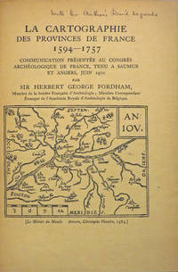
Cartography Maps; European History; Fordham Sir Herbert George.
A BOUND VOLUME CONTAINING TEN PAMPHLETS. ESSAYS ON CARTOGRAPHY ALL INSCRIBED BY THE AUTHOR.
Various places.: Various publishers 1908 to 1923. 10 volumes bound together in one volume. First Editions and all but one are inscribed by the author Illustrated with cartographic cover art re-impressions of important works cartographic decorations and a number of maps including a number that are folding. 8vo the original printed wraps to each pamphlet are present and all are bound into the one cloth covered volume brown morocco label gilt. Each pamphlet can be considered fine and in exemplary condition some evidence of use and a bit of age to the cloth covers. A fine collection. A FINE COLLECTION OF INSCRIBED FIRST EDITIONS. Ranging from the cartography of the provinces of France 1594 to British and Irish Itineraries and Road-Books English Counties Welsh a pamphlet on the Evolution of the Maps of the Bristish Isles on the great engraver and mapmaker John Cary and two on France cartography and routes from the mid-1500's until the middle of the 19th century. ALL BOOKS ARE INSCRIBED BY THE AUTHOR. Various publishers hardcover
書籍販売業者の参照番号
: 27846
|
|
|
Cartography
A Link with Magellan. Being a Chart of the East Indies c. 1522. In the possession of Boies Penrose
N.p.: Privately printed by William F. Fell Co 1929. No. 19 of 150 copies. 16 unnumbered pages of text with a color facsimile of the chart at the center. 1 vols. 4to. Original cloth backed boards printed paper label. No. 19 of 150 copies. 16 unnumbered pages of text with a color facsimile of the chart at the center. 1 vols. 4to. With excerpts from Eden's translation of Peter Martyr's version of Pigafetta's Journal. Privately printed by William F. Fell Co unknown
書籍販売業者の参照番号
: 40332
|
|
|
CARTOGRAPHY
Atlas of Hawaii
Honolulu: University of Hawaii Press 1983. Second Edition. pictorial wrappers. Wrappers a bit rubbed at front corners lower spine end and lower edges rubbed one four inch crease on front cover else fine. Oblong quarto. Profusely illustrated With bibliography tables and gazeteer. University of Hawaii Press unknown
書籍販売業者の参照番号
: 14617
|
|
|
Cartography Department of The Automobile Association
Birmingham Street by Street
Windsor Berks. England: AA Publishing 2003. Map-book. Interior is clean and bright. Second Edition. paperback. Very Good/No Dust Jacket. Used. AA Publishing Paperback
書籍販売業者の参照番号
: 107746 ISBN : 0749539305 9780749539306

|
|
|
Cartography Department of The Automobile Association
Birmingham Street by Street
Windsor Berks. England: AA Publishing 2003. Map-book. Interior is clean and bright. Second Edition. paperback. Very Good/No Dust Jacket. Clean Copy. AA Publishing Paperback
書籍販売業者の参照番号
: 107745 ISBN : 0749539305 9780749539306
|
|
|
CARTOGRAPHY
CATALOGUE OF THE MANUSCRIPT: Maps Charts and Plans.
1861. CARTOGRAPHY. CATALOGUE OF THE MANUSCRIPT: Maps Charts and Plans and of the Topographical Drawings in the British Museum. Volume III only. London: Printed by Order of the Trustees 1861. A photostat copy of Vol. 3 in two volumes i.e. a Complete Volume III the final volume of this catalogue. Tall 8vo. brown library binding. Ex-library sun to spine touch of soil dust soil to top-edge. unknown
書籍販売業者の参照番号
: 62731
|
|
|
Cartography Department of The Automobile Association
Central Birmingham Street by Street
Windsor Berks. England: AA Publishing 2003. Folding map. Map is clean and bright. First Edition. paperback. Very Good/No Dust Jacket. Clean Copy. AA Publishing Paperback
書籍販売業者の参照番号
: 107744 ISBN : 0749539186 9780749539184

|
|
|
Cartography Department of The Automobile Association
Central Birmingham Street by Street
Windsor Berks. England: AA Publishing 2003. Folding map. Map is clean and bright. First Edition. paperback. Very Good/No Dust Jacket. Clean Copy. AA Publishing Paperback
書籍販売業者の参照番号
: 107743 ISBN : 0749539186 9780749539184
|
|
|
Cartography Department of The Automobile Association
Exeter
AA Publishing. Used - Good. Ships from the UK. Former Library book. Shows some signs of wear and may have some markings on the inside. 100% Money Back Guarantee. Your purchase also supports literacy charities. AA Publishing unknown
書籍販売業者の参照番号
: GRP111229876 ISBN : 0749548568 9780749548568
|
|
|
Cartography Department of The Automobile Association
Exeter Street by Street
Basingstoke Hampshire United Kingdom: AA Publishing 2006. Book-map. Small scrape on the bottom of back cover minor chipping to bottom edges of pages 49 and 51 otherwise interior is clean and bright. Third Edition. paperback. Good/No Dust Jacket. Clean Copy. AA Publishing Paperback
書籍販売業者の参照番号
: 107780 ISBN : 0749548568 9780749548568
|
|
|
Cartography Penguin
Fish Australia
Viking Cartographic 11/1/1995. Hardcover. Very_Good. VERY GOOD -- LIGHT shelf wear to DJ. Sorry due to weight and size -- no international or priority shipping. Buy with confidence -- satisfaction guaranteed. Viking Cartographic hardcover
書籍販売業者の参照番号
: 30466 ISBN : 0670860409 9780670860401

|
|
|
Cartography
Map Collector's Circle Nos. 1-110. AND The Map Collector Nos 1-64.
Complete run of "Map Collector's Circle" Nos. 1-110 1963-1975. All in orig. wrappers. The first 50 issues in cloth folders with titles on spines supplied by publisher all in very good condition. AND Consecutive run of "The Map Collector" Nos. 1-64 Dec. 1977 - Autumn 1993. With indexes as issued for Nos. 1-60. All in very good condition. hardcover
書籍販売業者の参照番号
: 1147
|
|
|
Cartography Penguin
Penguin Road Map: Adelaide
Explore Australia 2000. This is an ex-library book and may have the usual library/used-book markings inside.This book has soft covers. In fair condition suitable as a study copy. Please note the Image in this listing is a stock photo and may not match the covers of the actual item150grams ISBN:9780140289879 Explore Australia paperback
書籍販売業者の参照番号
: 4562204 ISBN : 0140289879 9780140289879
|
|
|
Cartography by Benchmark Maps; David JR. Peckarsky Editor; Bob Lindquist & Robert Kemp Illustrator; J. R.
Portland Map Portland Willamette Valley Road & Recreation Map 8th Edition
Great Pacific Recreation & Travel Maps 2013-05-15. Map. Used:Good. Great Pacific Recreation & Travel Maps unknown
書籍販売業者の参照番号
: DADAX093801143X ISBN : 093801143X 9780938011439
|
|
|
Cartography Bartholomew
Random House Compact World Atlas
Random House Reference. Hardcover. 0679743308 Random House 1992 paperback . New. Random House Reference hardcover
書籍販売業者の参照番号
: SKU1142111 ISBN : 0679743308 9780679743309

|
|
|
CARTOGRAPHY OF THE SHORES AND ISLANDS OF GREECE.
Society for Hellenic Cartography 7th International Symposium 1989. Athens National Gallery 12 September - 8 October 1989.
Athens Soc. for Hell. Cartography 1989. 84 p. ills. Stiff wrs. 23x24 cm In English & Newgreek; publ. on occasion of the symp. unknown
書籍販売業者の参照番号
: 115471
|
|
|
Cartographie Dufrenoy
Stadtkarte PARIS Masstab 1 / 20.700
Verlag Hermann Hillger K.G. Berlin-Grunewald u. Leipzig. unknown. gebraucht sehr gut Sehr gutes Exemplar. 48x62cm. Auf Anfrage per E-Mail können Sie die bei uns bestellten Artikel auch in unserer Buchscheune 01796 Struppen Mo.-Fr. 9-16 Uhr oder im Antiquariat Schloss Pillnitz 01326 Dresden Mo.-So. 10-18 Uhr abholen. Verlag Hermann Hillger K.G. Berlin-Grunewald u. Leipzig unknown
書籍販売業者の参照番号
: H10901
|
|
|
Cartography Penguin
The New South Wales Fishing Atlas
1997-02-15. Good. Ships with Tracking Number! INTERNATIONAL WORLDWIDE Shipping available. May not contain Access Codes or Supplements. May be re-issue. May be ex-library. Shipping & Handling by region. Buy with confidence excellent customer service! unknown
書籍販売業者の参照番号
: 0140263373 ISBN : 0140263373 9780140263374

|
|
|
CARTOGRAPHIE
Carte routière Belgique - Wegenkaart van Belgie - Road Map of Belgium : Feuille R 2. (Echelle 1/200.000e).
Institut Géographique Militaire, 1960 (2e édition). Plan format 125 x 55 cm, sous couverture.- Tirage en couleurs.
書籍販売業者の参照番号
: 80081
|
|
|
CARTOGRAPHIE
Carte routière Belgique - Wegenkaart van Belgie - Road Map of Belgium : Feuille R 2. (Echelle 1/200.000e).
Plan format 125 x 55 cm, sous couverture.- Tirage en couleurs. Très bon état général. [ARCH]
|
|
|
CARTOGRAPHIE
Carte routière Taride n°1 NORD DE LA FRANCE et BELGIQUE Section Ouest (Échelle 1/250.000)
Paris, A. Taride, s.d. 70 x 90 cm. Carte sous pochette papier.Tirage en 4 couleurs.
書籍販売業者の参照番号
: 81572
|
|
|
CARTOGRAPHIE - CONGO
Carte routière officielle de la Province Orientale. Echelle 1/1,000,000
Institut Géographique du Congo Belge, 1953. Plan format 100x110, sous couverture.- Tirage en 2 couleurs.
書籍販売業者の参照番号
: 76838
|
|
|
CARTOGRAPHIE - CONGO
Carte routière officielle de la Province Orientale. Echelle 1/1,000,000
Plan format 100x110, sous couverture.- Tirage en 2 couleurs. Excellent état général. [ARCH]
|
|
|
CARTOGRAPHIE AU XVIIIème SIÈCLE ET L'ŒUVRE DU COMTE DE FERRARIS (1726-1814) (LA).
De la cartografie in de 18 de Euww En Het.
Spa, Crédit communal de Belgique, 1978, in-8, br., 317 pp., planches et cartes h.-t., dont plusieurs dépliantes et en couleurs. (L211)
書籍販売業者の参照番号
: 1352411
|
|
 検索結果のメールを受信する
 PDFファイルの検索結果をダウンロード
 RSSフィード


