|
|
|
Hall, Sidney; Hughes; etc
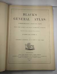
Black's General Atlas: Comprehending Sixty-One Maps. Engraved on Steel. with Geographic Descriptions and Index of 56000 Names
Edinburgh / London / Dublin: Adam and Charles Black / Longman / Simpkin / Whittaker / Hamilton / Cumming 1844. Good - Very Good condition. Bound in green cloth with black leather spine and corners elaborately gilt decorated. The leather is surprisingly well preserved. The cloth is faded and soiled with frayed edges. SEE PHOTOS. NO owner's name or bookplate. NOT a library discard. Imprinted "MDCCCXLIV" at the foot of the title page with "1844" hand inked beneath. All other pages are crisp clean and umarked with almost no foxing. Full title; "Black's General Atlas: Comprehending Sixty-One Maps from the Latest and Most Authentic Sources Engraved on Steel in the First Style of the Art by Sidney Hall Hughes etc. with Geographic Descriptions and an Index of 56000 Names." The maps several double page are tissue guarded and most are handcolored in red yellow and green. SEE PHOTOS. With the binder's ticket of Smith & Son 306 Lawnmarket Edinburgh. All edges gilt. Oversize hardcover. 13.25" wide by 17.75" tall. This large heavy book will require SUBSTANTIAL extra postage depending on destination that will be charged at our cost. 1844 edition. Oversize Hardcover. Good - Very Good condition. Illus. by NOT a library discard. 12pp. 61 maps 57 page Index. Great Packaging Fast Shipping. Adam and Charles Black / Longman / Simpkin / Whittaker / Hamilton / Cumming Hardcover
Riferimento per il libraio : 026815
|
|
|
Hall, Sidney
DENMARK
Edinburgh: A&C Black 1842. No Binding. Fine/uncoloured. Folding MAP OF DENMARK. Beautiful steel engraving from Encyclopaedia Britanica Seventh edition dated 1842. Plate CCLXXXIV. Fine example with no wear. 410x260mm. Relief is shown by hachures. Engraved by S. Hall Bury Strt. Bloomsbury. Published by A. & C. Black. <br/> <br/> A&C Black unknown
Riferimento per il libraio : Map 807
|
|
|
Hall, Sidney
EASTERN ISLANDS BIRMAH & C.
Edinburgh: A&C Black 1842. No Binding. Fine/uncoloured. Beautiful steel engraving from Encyclopaedia Britanica Seventh edition dated 1842. Plate CCCVII -1 Fine example with no wear. 410x260mm. Engraved by Sidney Hall Bloomsbury. Published by A. & C. Black. An area extending from Birmah Indonesia and the Straits of Malacca to China and the Philippines. <br/> <br/> A&C Black unknown
Riferimento per il libraio : Mao 810
|
|
|
Hall, Sidney
ENGLAND AND WALES 2 MAPS Parts 1 AND 2
Edinburgh: A&C Black 1842. No Binding. Fine/uncoloured. Beautiful steel engravings from Encyclopaedia Britanica Seventh edition dated 1842. Plates CCCXVIII and CCXIX 1-2 . Fine examples with no wear. Trifle foxing. 270x380mm. Engraved by Sidney Hall Bloomsbury. Published by A. & C. Black. <br/> <br/> A&C Black unknown
Riferimento per il libraio : Map 818
|
|
|
Hall, Sidney
GERMANY 2 MAPS Northern and Southern Sheets
Edinburgh: A&C Black 1842. No Binding. Fine/uncoloured. Beautiful steel engravings from Encyclopaedia Britanica Seventh edition dated 1842. Plates CCCXVIII and CCLXIV-V .Fine examples with no wear. 270x380mm. Engraved by Sidney Hall Bloomsbury. Published by A. & C. Black. <br/> <br/> A&C Black unknown
Riferimento per il libraio : Map 816
|
|
|
Hall, Sidney
IRELAND 2 MAPS Northern and Southern Sheets
Edinburgh: A&C Black 1842. No Binding. Fine/uncoloured. Beautiful steel engravings from Encyclopaedia Britanica Seventh edition dated 1842. Plates CCLXXVIII -1 and 2 .Fine example with no wear. 410x260mm. Engraved by Sidney Hall Bloomsbury. Published by A. & C. Black. <br/> <br/> A&C Black unknown
Riferimento per il libraio : Map 809
|
|
|
Hall, Sidney
ITALY 2 MAPS Northern and Southern Sheets
Edinburgh: A&C Black 1842. No Binding. Fine/uncoloured. Beautiful steel engravings from Encyclopaedia Britanica Seventh edition dated 1842. Plates CCCXVIII and CCCXIX .Fine example with no wear. 270x380mm. Engraved by Sidney Hall Bloomsbury. Published by A. & C. Black. <br/> <br/> A&C Black unknown
Riferimento per il libraio : mAP 813
|
|
|
Hall, Sidney
MAP PALESTINE
London: Longman Rees Orme Brown and Green Paternoster Row 1830. 1st Edition . printed Map. Fine. Folio. ND c1850 Plate XXX double page folding original map with outline hand coloured boundaries and relief shown by hachures. Finely engraved decorative wide border and wide margins to three sides. Strengthened hinge to the rear centre fold. PLEASE EMAIL FOR PHOTOS 42x53 cms <br/> <br/> Longman, Rees, Orme, Brown and Green, Paternoster Row unknown
Riferimento per il libraio : Map914
|
|
|
Hall, Sidney
THE WORLD Western and Eastern Twin Hemispheres
Edinburgh: A&C Black 1842. No Binding. Fine/uncoloured. Folding plate of the two hemispheres. Beautiful steel engraving from Encyclopaedia Britanica Seventh edition dated 1842. Plate CCLXII. Fine example with no wear. Couple of small fox marks. Engraved by S. Hall Bury Str. Bloomsbury. Australia is named 'Australia and New Holland'. 400x280mm. <br/> <br/> A&C Black unknown
Riferimento per il libraio : Map 805
|
|
|
Hall, Sydney
NORTH AMERICA
London: Longman Rees Orme Brown & Green 1829. 1st edition later issue . No Binding. Fine. Double page large folding map of North America with outline hand-colour to the boundaries and divisions and with a printed decorative border.57x49cms. Originally pub. in 1829 this folding issue had the dated neatly erased. The plate impress mark cropped on the upper half not affecting the border or map. Nicely coloured. Short tear to the upper edge with no loss. Neatly repaired. PLEASE EMAIL FOR PHOTOS. From Halls 'New General Atlas with the Divisions and Boundaries.1843 <br/> <br/> Longman, Rees, Orme, Brown & Green, unknown
Riferimento per il libraio : Map917
|
|
|
Haller, B. u. G. Tiggesbäumker
Die Kartensammlung d. Freiherrn August von Haxthausen in d. Universitätsbibliothek Münster.
Münster, 1978. IX, 204 S. (Westfälische Geogr. Stud. Beih. 2).
Riferimento per il libraio : 125620
|
|
|
Halman, L. Luijkx, R. / Zundert, M. van / L. Halman
Atlas of European Values
, Brill Academic Pub, 2005 Hardcover, 139 pages, ENG, 315 x 235 mm, in New condition!, with illustrations in colour. ISBN 9789004144606.
Riferimento per il libraio : 59584
|
|
|
Halman, L. Luijkx, R. / Zundert, M. van / L. Halman
Atlas of European Values
Hardcover, 139 pages, ENG, 315 x 235 mm, in New condition!, with illustrations in colour. ISBN 9789004144606. The Atlas presents European ideas and beliefs in the form graphs, charts and maps. Values such as democracy, freedom, equality, human dignity and solidarity are held by almost all Europeans, but the survey points to differing views about marriage, religion, work and such topics as euthanasia, happiness, sexuality and death. This unique Atlas covers all European nations from Iceland to Turkey, from Portugal to the Ukraine. It graphically illustrates the rich diversity that is Europe.

|
|
|
Halperin, Paphael
Atlas Eytz Chayim [IN HEBREW WITH ENGLISH INTRODUCTION]
Includes a map. Ex-library book- with all the usual marks. 22x28 cm. 300 pages. Hardcover. In good condition. PLEASE NOTE: This item is overweight. We may ask for extra shipping costs.
|
|
|
Halperin, Paphael
Atlas Eytz Chayim [IN HEBREW WITH ENGLISH INTRODUCTION]
Includes a map. 22x28 cm. 300 pages. Hardcover. Top and bottom of spine slightly worn. In good condition. PLEASE NOTE: This item is overweight. We may ask for extra shipping costs.
|
|
|
HAMID SEVKET INCE, (Turkish politician and lawyer), (1889-1968).
Autograph letter signed 'Hâmid Sevket Ince'.
Very Good Turkish, Ottoman (1500-1928) Original autograph letter signed 'Hâmid Sevket Ince'. 22x14 cm. In Ottoman script. 1 p. Full. Ince was a Turkish politician and a famous lawyer inAnkara city. He is a graduate of Istanbul University Faculty of Law. He served as the Deputy of Erzurum and Ankaraand he worked as a freelance lawyer. Dated 22/6/1936. Recipient was 'Mr. M. Sadik'. Punch holes on left side. A good paper with '...en Bank' watermarked.
|
|
|
Hamilton, AG A G
A NEW KEY To Unlock Every Kingdom State and Province in the Known World
London: Aldam and Co. Et al. 1839. 1st Edition . Hardback. Fine. 8vo. 100pp. Large folding table of distances frontis. A wonderful early Victorian geography in the orginal stiff card cover with fine buckram cloth cover and a lozenge label pasted to the front cover. A RARE ITEM. Copac 1 copy only 1839. A second edition was published in 1850. <br/> <br/> Aldam and Co. Et al. hardcover
Riferimento per il libraio : TH225
|
|
|
Hammer, E
Vergleichung einiger Abbildungen e. kleinen Stücks d. ellipsoidischen Erdoberfläche (Karte v. S.W.-Deutschland).
Halle, Engelmann, 1898. S. 447-470. Hlwd. Einbd. angeschmutzt, m. Sign. u. St.Vors. u. Tit. m. St. (Nova acta Leop. 71/9).
Riferimento per il libraio : 120560
|
|
|
HAMY, Dr E.-T.
Jean Roze Hydrographe Dieppois du milieu du XVIe siècle.
Paris, Ernest Leroux, 1890 ; brochure grand in-8°, couverture vert d'eau imprimée en noir;10pp.Extrait du Bulletin de Géographie historique et descriptive , tome IV, n°2.
Riferimento per il libraio : c5654
|
|
|
HAMY, Dr E.T
Note sur une Carte Marine inédite de Giacomo Russo de Messine ( 1557).
Paris, Ernest Leroux, 1888 ;brochure grand in-8°, couverture vert d'eau imprimée en noir;16pp. ;1 figure dans le texte et 1 planche hors texte volante.Bon exemplaire.
Riferimento per il libraio : c5651
|
|
|
HAMY, Dr E.T.
Note sur la Mappemonde de Diego Ribero ( 1529) Conservée au Musée de la Propagande de Rome.
Paris, Ernest Leroux, 1887 ; brochure grand in-8°, couverture grise imprimée en noir;10pp. Tiré à part du Bulletin de Géographie historique et descriptive, 1887, n°1.
Riferimento per il libraio : c5649
|
|
|
HAMY, E. -T.
Les Origines de la Cartographie de l' Europe Septentrionale.
Paris, Ernest Leroux, 1889 ; grand in-8°, couverture vert d'eau imprimée en noir; 104pp., et 5 cartes hors texte ( numérotées V à IX).Petits accrocs en bordure de la couverture, dos cassé, bon état intérieur.
Riferimento per il libraio : cROU-661
|
|
|
Hancock, Graham
L'impronta degli dei
Alla ricerca dell'inizio e della fine. L'autore intraprende una ricerca ad ampio raggio sulla preistoria dell'umanità.
|
|
|
Hanke, M. u. H. Degner
Die Pflege der Kartographie bei der Königlich Preussischen Akademie der Wissenschaften unter der Regierung Friedrichs des Grossen. Mit einem Vorworte und Beiträgen von A. Penck.
Berlin, 1934. 4°. 68 S. OBr. Umschl. lichtrandig. Unaufgeschn. Ex. Leicht knickspurig. Textsauber. (Aus den Abhandlungen der Preussischen Akademie der Wissenschaften).
Riferimento per il libraio : 118097
|
|
|
HANNINCK Pierre & DUVOSQUEL Jean-Marie
La carte d'Arenberg de la terre et prévoté de Neufchateau en 1609, avec le ban de Mellier et la seigneurie de Bertrix. Edition commentée et enrichie d'un dossier cartographique
Bruxelles, Crédit Communal 1996 173pp. richement illustré en couleurs et en n/bl, 35cm., reliure toile d'éditeur, jaquette illustrée, très bon état, B92710
Riferimento per il libraio : B92710
|
|
|
HANNINCK Pierre & DUVOSQUEL Jean-Marie
La carte d'Arenberg de la terre et prévoté de Neufchateau en 1609, avec le ban de Mellier et la seigneurie de Bertrix. Edition commentée et enrichie d'un dossier cartographique
173pp. richement illustré en couleurs et en n/bl, 35cm., reliure toile d'éditeur, jaquette illustrée, très bon état, B92710
|
|
|
HANS JOACHIM KISSLING, (1912-1985).
Probleme der alteren osmanischen Schwarzmeer-Kartographie.
Very Good German Paperback. Roy. 8vo. (23 x 16 cm). In German. 28 p., 6 plates of maps, 1 huge folding map on back pocket. Probleme der alteren osmanischen Schwarzmeer-Kartographie. First Edition.
|
|
|
HARITA DAIRESI.
[MAP] Ottoman map of Erzurum.
Very Good Turkish, Ottoman (1500-1928) Original color map of Erzurum city center and it environment. Folded. 69x42,5 cm. In Ottoman script. One sheet. Shows center of Erzurum city and topography environment. No scale info. Hegira: 1336 = Gregorian: 1920. Not description on map-maker. This is one the serie of the Bonn projection maps which are the first map series in modern techniques in Turkey and the Ottoman Empire. In order to produce these maps covering Turkish territory, Reconnaissance Branch was incorporated into The Mapping Commission. The maps were produced in the datum based on the latitude and longitude of Ayasofya Mosque in equal area Bonn Projection. The field works for the 123 sheets covering the country were conducted by 76 staff. The production was completed in 18 years starting from east west. Field works continued without stopping except in years 1914 and 1920. This map series called also reconnaissance maps contributed a lot to producing 1:25.000 scale maps. Extremely rare.
|
|
|
HARITA DAIRESI].
[MAP of Ankara city] Ankara. Gerede, Keskin, Sivrihisar.
Very Good Turkish, Ottoman (1500-1928) Original map. Oblong elephant folio. (50 x 60 cm). In Ottoman script. Scale: 1/200.000. [MAP of Ankara city]. Ankara. Gerede, Keskin, Sivrihisar. A rare Ottoman map printed in last period shows Ankara city with detailed place names. This is one the serie of the Bonn projection maps which are the first map series in modern techniques in Turkey and the Ottoman Empire. In order to produce these maps covering Turkish territory, Reconnaissance Branch was incorporated into The Mapping Commission. The maps were produced in the datum based on the latitude and longitude of Ayasofya Mosque in equal area Bonn Projection. The field works for the 123 sheets covering the country were conducted by 76 staff. The production was completed in 18 years starting from east west. Field works continued without stopping except in years 1914 and 1920. This map series called also reconnaissance maps contributed a lot to producing 1:25.000 scale maps.
|
|
|
HARITA UMUM MÜDÜRLÜGÜ = MAP GENERAL DIRECTORY].
[MAP of TURKISH BALKANS, ALBANIA and GREECE] 52. Berat. 57. Arkeri. 23. Avlonya. 24. Himar (Heymar) (Ottoman Albania and Greece). Mübde-i Tûl Paris'den itibâr olunmusdur. [Berati, Vlora, Himara (Himarra)].
Very Good Turkish, Ottoman (1500-1928) Original color map on cloth. A little foxing on cloth. Very good. Folded. Oblong atlas folio. (66 x 72 cm). In Ottoman script. Scale: 1/210.000. Ottoman sanjaks in Albania and Greece. A rare Ottoman map of Balkans with Turkish place names for the period of pre-Balkan Wars, (1912-1913). Very important for onomastics and historical geography. Written 'Paris -French meridian- was accepted as the 0 meridian'. The Paris meridian is a meridian line running through the Paris Observatory in Paris, France-now longitude 2°20'14.03" east. It was a long-standing rival to the Greenwich meridian as the prime meridian of the world. Personal stamp of Muhiddin Pasha on cloth, under the printed descriptive texts. It's from the collection of him. Hasan Muhiddin Pasha [Çanga], (1866-1944), who was a lieutenant in Hedjaz Army of the Ottoman Empire in 1887. After he suppressed the rebellion in Yemen, 1891, his rank was promoted to the 'major'. After the Imam Yahya rebellion in Yemen, 1904, he prepared a report for the Ottoman government. He also took part in Ethiopia, Sudan, Yemen, Arabian Peninsula for various military duties. After promotion to division command, he was provincial president of CHP (Republican People's Party). He was a very important politic and diplomatic figure for the last period of Ottoman and early Republican Turkey. Not in Tooley. Extremely rare.
|
|
|
HARITA UMUM MÜDÜRLÜGÜ = MAP GENERAL DIRECTORY].
[MAP of TURKISH BALKANS, ALBANIA, MACEDONIA and GREECE] 44. Debre-i Bâlâ. 55. Ilbesan. 61. Lis. 62. Draç. Mübde-i Tûl Paris'den itibâr olunmusdur. [Debre, Elbasan, Drac, Lish].
Very Good Turkish, Ottoman (1500-1928) Original color map on cloth. A little foxing on cloth. Very good. Folded. Oblong atlas folio. (66 x 72 cm). In Ottoman script. Scale: 1/210.000. Ottoman sanjaks in Albania, Macedonia and Greece. A rare Ottoman map of Balkans with Turkish place names for the period of pre-Balkan Wars, (1912-1913). Very important for onomastics and historical geography.
|
|
|
HARITA UMUM MÜDÜRLÜGÜ = MAP GENERAL DIRECTORY].
[MAP of TURKISH BALKANS, BULGARIA] 15. Kazanlik. 16. Hasköy. 21. Karlova. 22. Filibe (Plovdiv). Mübde-i Tûl Paris'den itibâr olunmusdur. [Plovdiv, Karlovo, Haskovo, Kizanlik / Kazanlyk - Bulgaria].
Very Good Turkish, Ottoman (1500-1928) Original color map on cloth. A little foxing on cloth. Very good. Folded. Oblong atlas folio. (66 x 72 cm). In Ottoman script. Scale: 1/210.000. Ottoman cities in Bulgaria. A rare Ottoman map of Balkans with Turkish place names for the period of pre-Balkan Wars, (1912-1913). Very important for onomastics and historical geography. Written 'Paris -French meridian- was accepted as the 0 meridian'. The Paris meridian is a meridian line running through the Paris Observatory in Paris, France-now longitude 2°20'14.03" east. It was a long-standing rival to the Greenwich meridian as the prime meridian of the world. Personal stamp of Muhiddin Pasha on cloth, under the printed descriptive texts. It's from the collection of him. Hasan Muhiddin Pasha [Çanga], (1866-1944), who was a lieutenant in Hedjaz Army of the Ottoman Empire in 1887. After he suppressed the rebellion in Yemen, 1891, his rank was promoted to the 'major'. After the Imam Yahya rebellion in Yemen, 1904, he prepared a report for the Ottoman government. He also took part in Ethiopia, Sudan, Yemen, Arabian Peninsula for various military duties. After promotion to division command, he was provincial president of CHP (Republican People's Party). He was a very important politic and diplomatic figure for the last period of Ottoman and early Republican Turkey. Not in Tooley. Extremely rare.
|
|
|
HARITA UMUM MÜDÜRLÜGÜ = MAP GENERAL DIRECTORY].
[MAP of TURKISH BALKANS, BULGARIA] Eski Zagra. [Stara Zagora - Old Zagora].
Very Good Turkish, Ottoman (1500-1928) Original color map on cloth. A little foxing on cloth. Very good. Folded. Oblong atlas folio. (66 x 72 cm). In Ottoman script. Scale: 1/210.000. Ottoman sanjaks in Balkans, Bulgaria. A very detailed map of Old Zagora. A rare Ottoman map of Balkans with Turkish place names for the period of pre-Balkan Wars, (1912-1913). Very important for onomastics and historical geography. Extremely rare.
|
|
|
HARITA UMUM MÜDÜRLÜGÜ = MAP GENERAL DIRECTORY].
[MAP of TURKISH BALKANS, BULGARIA] Filibe - Hasköy. [Plovdiv - Haskovo].
Very Good Turkish, Ottoman (1500-1928) Original color map on cloth. A little foxing on cloth. Very good. Folded. Oblong atlas folio. (66 x 72 cm). In Ottoman script. Scale: 1/210.000. Ottoman sanjaks in Balkans, Bulgaria. A very detailed map of Plovdiv and Haskovo. A rare Ottoman map of Balkans with Turkish place names for the period of pre-Balkan Wars, (1912-1913). Very important for onomastics and historical geography. Extremely rare.
|
|
|
HARITA UMUM MÜDÜRLÜGÜ = MAP GENERAL DIRECTORY].
[MAP of TURKISH BALKANS, BULGARIA] Filibe. [Plovdiv].
Very Good Turkish, Ottoman (1500-1928) Original color map on cloth. A little foxing on cloth. Very good. Folded. Oblong atlas folio. (66 x 72 cm). In Ottoman script. Scale: 1/210.000. Ottoman sanjaks in Balkans, Bulgaria. A very detailed map of Plovdiv. A rare Ottoman map of Balkans with Turkish place names for the period of pre-Balkan Wars, (1912-1913). Very important for onomastics and historical geography. Extremely rare.
|
|
|
HARITA UMUM MÜDÜRLÜGÜ = MAP GENERAL DIRECTORY].
[MAP of TURKISH BALKANS, GREECE, MACEDONIA] 28. Nurekob. 29. Siroz. 34. Usturumçe (Macedonia). 35. Teviran. Mübde-i Tûl Paris'den itibâr olunmusdur. [Serres, Macedonia, Greece].
Very Good Turkish, Ottoman (1500-1928) Original color map on cloth. A little foxing on cloth. Very good. Folded. Oblong atlas folio. (66 x 72 cm). In Ottoman script. Scale: 1/210.000. Ottoman sanjaks in Greece, mostly in Greek Macedonia. A rare Ottoman map of Balkans with Turkish place names for the period of pre-Balkan Wars, (1912-1913). Very important for onomastics and historical geography. Written 'Paris -French meridian- was accepted as the 0 meridian'. The Paris meridian is a meridian line running through the Paris Observatory in Paris, France-now longitude 2°20'14.03" east. It was a long-standing rival to the Greenwich meridian as the prime meridian of the world. Personal stamp of Muhiddin Pasha on cloth, under the printed descriptive texts. It's from the collection of him. Hasan Muhiddin Pasha [Çanga], (1866-1944), who was a lieutenant in Hedjaz Army of the Ottoman Empire in 1887. After he suppressed the rebellion in Yemen, 1891, his rank was promoted to the 'major'. After the Imam Yahya rebellion in Yemen, 1904, he prepared a report for the Ottoman government. He also took part in Ethiopia, Sudan, Yemen, Arabian Peninsula for various military duties. After promotion to division command, he was provincial president of CHP (Republican People's Party). He was a very important politic and diplomatic figure for the last period of Ottoman and early Republican Turkey. Not in Tooley. Extremely rare.
|
|
|
HARITA UMUM MÜDÜRLÜGÜ = MAP GENERAL DIRECTORY].
[MAP of TURKISH BALKANS, GREECE, MACEDONIA] 40. Istib. 41. Vodina. 46. Kirçova. 47. Manastir. Mübde-i Tûl Paris'den itibâr olunmusdur. [Stip, Edessa, Adende, Monaster; Macedonia, Greece].
Very Good Turkish, Ottoman (1500-1928) Original color map on cloth. A little foxing on cloth. Very good. Folded. Oblong atlas folio. (66 x 72 cm). In Ottoman script. Scale: 1/210.000. Ottoman sanjaks in Greece, mostly in Greek Macedonia. A rare Ottoman map of Balkans with Turkish place names for the period of pre-Balkan Wars, (1912-1913). Very important for onomastics and historical geography. Written 'Paris -French meridian- was accepted as the 0 meridian'. The Paris meridian is a meridian line running through the Paris Observatory in Paris, France-now longitude 2°20'14.03" east. It was a long-standing rival to the Greenwich meridian as the prime meridian of the world. Personal stamp of Muhiddin Pasha on cloth, under the printed descriptive texts. It's from the collection of him. Hasan Muhiddin Pasha [Çanga], (1866-1944), who was a lieutenant in Hedjaz Army of the Ottoman Empire in 1887. After he suppressed the rebellion in Yemen, 1891, his rank was promoted to the 'major'. After the Imam Yahya rebellion in Yemen, 1904, he prepared a report for the Ottoman government. He also took part in Ethiopia, Sudan, Yemen, Arabian Peninsula for various military duties. After promotion to division command, he was provincial president of CHP (Republican People's Party). He was a very important politic and diplomatic figure for the last period of Ottoman and early Republican Turkey. Not in Tooley. Extremely rare.
|
|
|
HARITA UMUM MÜDÜRLÜGÜ = MAP GENERAL DIRECTORY].
[MAP of TURKISH BALKANS, GREECE, THESSALY] 50. Narda (Yunanistan). 51. Preveze (Yunanistan). 67. Tirhala (Yunanistan). 70. Agrinyon (Yunanistan-Teselya). Mübde-i Tûl Paris'den itibâr olunmusdur. [Arta (Yunanistan), Preveza (Greece), Sandjak of Tirhala (Thessaly-Greece), Agrinio (Thessaly-Greece)]
Very Good Turkish, Ottoman (1500-1928) Original color map on cloth. A little foxing on cloth. Very good. Folded. Oblong atlas folio. (66 x 72 cm). In Ottoman script. Scale: 1/210.000. Ottoman sanjaks in Greece, mostly in Thessaly. A rare Ottoman map of Balkans with Turkish place names for the period of pre-Balkan Wars, (1912-1913). Very important for onomastics and historical geography. Written 'Paris -French meridian- was accepted as the 0 meridian'. The Paris meridian is a meridian line running through the Paris Observatory in Paris, France-now longitude 2°20'14.03" east. It was a long-standing rival to the Greenwich meridian as the prime meridian of the world. Personal stamp of Muhiddin Pasha on cloth, under the printed descriptive texts. It's from the collection of him. Hasan Muhiddin Pasha [Çanga], (1866-1944), who was a lieutenant in Hedjaz Army of the Ottoman Empire in 1887. After he suppressed the rebellion in Yemen, 1891, his rank was promoted to the 'major'. After the Imam Yahya rebellion in Yemen, 1904, he prepared a report for the Ottoman government. He also took part in Ethiopia, Sudan, Yemen, Arabian Peninsula for various military duties. After promotion to division command, he was provincial president of CHP (Republican People's Party). He was a very important politic and diplomatic figure for the last period of Ottoman and early Republican Turkey. Not in Tooley. Extremely rare.
|
|
|
HARITA UMUM MÜDÜRLÜGÜ = MAP GENERAL DIRECTORY].
[MAP of TURKISH BALKANS, GREECE, THESSALY] 65. Iskoplus (Üsküplo-Uskublo) (Yunanistan). 66. Galos (Teselya, Yunanistan). 68. Egriboz. 69. Lami (Izdin) (Thesalya, Yunanistan). Mübde-i Tûl Paris'den itibâr olunmusdur. [Volos, Skopelos, Euboea, Lamia (Thessaly, Greece).
Very Good Turkish, Ottoman (1500-1928) Original color map on cloth. A little foxing on cloth. Very good. Folded. Oblong atlas folio. (66 x 72 cm). In Ottoman script. Scale: 1/210.000. Ottoman sanjaks in Greece, mostly in Thessaly. A rare Ottoman map of Balkans with Turkish place names for the period of pre-Balkan Wars, (1912-1913). Very important for onomastics and historical geography. Written 'Paris -French meridian- was accepted as the 0 meridian'. The Paris meridian is a meridian line running through the Paris Observatory in Paris, France-now longitude 2°20'14.03" east. It was a long-standing rival to the Greenwich meridian as the prime meridian of the world. Personal stamp of Muhiddin Pasha on cloth, under the printed descriptive texts. It's from the collection of him. Hasan Muhiddin Pasha [Çanga], (1866-1944), who was a lieutenant in Hedjaz Army of the Ottoman Empire in 1887. After he suppressed the rebellion in Yemen, 1891, his rank was promoted to the 'major'. After the Imam Yahya rebellion in Yemen, 1904, he prepared a report for the Ottoman government. He also took part in Ethiopia, Sudan, Yemen, Arabian Peninsula for various military duties. After promotion to division command, he was provincial president of CHP (Republican People's Party). He was a very important politic and diplomatic figure for the last period of Ottoman and early Republican Turkey. Not in Tooley. Extremely rare.
|
|
|
HARITA UMUM MÜDÜRLÜGÜ = MAP GENERAL DIRECTORY].
[MAP of TURKISH BALKANS, GREECE] 17. Gümülcine. 18. Karaagaç. 23. Pasmakli. 24. Kavala. Mübde-i Tûl Paris'den itibâr olunmusdur. [Komotini, Ftelia, Kavala, et alli].
Very Good Turkish, Ottoman (1500-1928) Original color map on cloth. A little foxing on cloth. Very good. Folded. Oblong atlas folio. (66 x 72 cm). In Ottoman script. Scale: 1/210.000. Ottoman sanjaks in Greece. A rare Ottoman map of Balkans with Turkish place names for the period of pre-Balkan Wars, (1912-1913). Very important for onomastics and historical geography. Written 'Paris -French meridian- was accepted as the 0 meridian'. The Paris meridian is a meridian line running through the Paris Observatory in Paris, France-now longitude 2°20'14.03" east. It was a long-standing rival to the Greenwich meridian as the prime meridian of the world. Personal stamp of Muhiddin Pasha on cloth, under the printed descriptive texts. It's from the collection of him. Hasan Muhiddin Pasha [Çanga], (1866-1944), who was a lieutenant in Hedjaz Army of the Ottoman Empire in 1887. After he suppressed the rebellion in Yemen, 1891, his rank was promoted to the 'major'. After the Imam Yahya rebellion in Yemen, 1904, he prepared a report for the Ottoman government. He also took part in Ethiopia, Sudan, Yemen, Arabian Peninsula for various military duties. After promotion to division command, he was provincial president of CHP (Republican People's Party). He was a very important politic and diplomatic figure for the last period of Ottoman and early Republican Turkey. Not in Tooley. Extremely rare.
|
|
|
HARITA UMUM MÜDÜRLÜGÜ = MAP GENERAL DIRECTORY].
[MAP of TURKISH BALKANS, GREECE] 25. Kareles. 30. Poliroz. 31. Kesendire. 36. Selânik. 37. Litohor. Mübde-i Tûl Paris'den itibâr olunmusdur. [Litochoro, Thessaloniki (Salonica-Salonique), Kassandra, Kassandreia, Polygyros, et alli.].
Very Good Turkish, Ottoman (1500-1928) Original color map on cloth. A little foxing on cloth. Very good. Folded. Oblong atlas folio. (66 x 72 cm). In Ottoman script. Scale: 1/210.000. Ottoman sanjaks in Greece. A rare Ottoman map of Balkans with Turkish place names for the period of pre-Balkan Wars, (1912-1913). Very important for onomastics and historical geography. Written 'Paris -French meridian- was accepted as the 0 meridian'. The Paris meridian is a meridian line running through the Paris Observatory in Paris, France-now longitude 2°20'14.03" east. It was a long-standing rival to the Greenwich meridian as the prime meridian of the world. Personal stamp of Muhiddin Pasha on cloth, under the printed descriptive texts. It's from the collection of him. Hasan Muhiddin Pasha [Çanga], (1866-1944), who was a lieutenant in Hedjaz Army of the Ottoman Empire in 1887. After he suppressed the rebellion in Yemen, 1891, his rank was promoted to the 'major'. After the Imam Yahya rebellion in Yemen, 1904, he prepared a report for the Ottoman government. He also took part in Ethiopia, Sudan, Yemen, Arabian Peninsula for various military duties. After promotion to division command, he was provincial president of CHP (Republican People's Party). He was a very important politic and diplomatic figure for the last period of Ottoman and early Republican Turkey. Not in Tooley. Extremely rare.
|
|
|
HARITA UMUM MÜDÜRLÜGÜ = MAP GENERAL DIRECTORY].
[MAP of TURKISH BALKANS, MACEDONIA] Usturumca (Strumica), Siroz (Serres), Toyran (Doyran), Nevre-i Kob.
Very Good Turkish, Ottoman (1500-1928) Original color map on cloth. A little foxing on cloth. Very good. Folded. Oblong atlas folio. (66 x 72 cm). In Ottoman script. Scale: 1/210.000. Ottoman sanjaks in Balkans, Macedonia. A very detailed map of Old Zagora. A rare Ottoman map of Balkans with Turkish place names for the period of pre-Balkan Wars, (1912-1913). Very important for onomastics and historical geography. Extremely rare.
|
|
|
HARITA UMUM MÜDÜRLÜGÜ = MAP GENERAL DIRECTORY].
[MAP of TURKISH BALKANS, MACEDONIAN GREECE, THESSALY] 42. Kirefrite. 43. Alasonya. 48. Nasliç, Naslig. 49. Yanya. Mübde-i Tûl Paris'den itibâr olunmusdur. [Elassona, Neapoli, Ioannina (Ottoman sandjakss in Thessaly, and Macedonian Greece).
Very Good Turkish, Ottoman (1500-1928) Original color map on cloth. A little foxing on cloth. Very good. Folded. Oblong atlas folio. (66 x 72 cm). In Ottoman script. Scale: 1/210.000. Ottoman sanjaks in Greece, mostly in Thessaly and Macedonian Greece. A rare Ottoman map of Balkans with Turkish place names for the period of pre-Balkan Wars, (1912-1913). Very important for onomastics and historical geography. Written 'Paris -French meridian- was accepted as the 0 meridian'. The Paris meridian is a meridian line running through the Paris Observatory in Paris, France-now longitude 2°20'14.03" east. It was a long-standing rival to the Greenwich meridian as the prime meridian of the world. Personal stamp of Muhiddin Pasha on cloth, under the printed descriptive texts. It's from the collection of him. Hasan Muhiddin Pasha [Çanga], (1866-1944), who was a lieutenant in Hedjaz Army of the Ottoman Empire in 1887. After he suppressed the rebellion in Yemen, 1891, his rank was promoted to the 'major'. After the Imam Yahya rebellion in Yemen, 1904, he prepared a report for the Ottoman government. He also took part in Ethiopia, Sudan, Yemen, Arabian Peninsula for various military duties. After promotion to division command, he was provincial president of CHP (Republican People's Party). He was a very important politic and diplomatic figure for the last period of Ottoman and early Republican Turkey. Not in Tooley. Extremely rare.
|
|
|
HARITA UMUM MÜDÜRLÜGÜ = MAP GENERAL DIRECTORY].
[MAP of TURKISH BALKANS] 26. Otluk Köyü. 27. Samako. 32. Sofiye. 33. Cumabâla. Mübde-i Tûl Paris'den itibâr olunmusdur.
Very Good Turkish, Ottoman (1500-1928) Original color map on cloth. A little foxing on cloth. Very good. Folded. Oblong atlas folio. (66 x 72 cm). In Ottoman script. Scale: 1/210.000. Ottoman sanjaks in Balkans. A rare Ottoman map of Balkans with Turkish place names for the period of pre-Balkan Wars, (1912-1913). Very important for onomastics and historical geography. Written 'Paris -French meridian- was accepted as the 0 meridian'. The Paris meridian is a meridian line running through the Paris Observatory in Paris, France-now longitude 2°20'14.03" east. It was a long-standing rival to the Greenwich meridian as the prime meridian of the world. Personal stamp of Muhiddin Pasha on cloth, under the printed descriptive texts. It's from the collection of him. Hasan Muhiddin Pasha [Çanga], (1866-1944), who was a lieutenant in Hedjaz Army of the Ottoman Empire in 1887. After he suppressed the rebellion in Yemen, 1891, his rank was promoted to the 'major'. After the Imam Yahya rebellion in Yemen, 1904, he prepared a report for the Ottoman government. He also took part in Ethiopia, Sudan, Yemen, Arabian Peninsula for various military duties. After promotion to division command, he was provincial president of CHP (Republican People's Party). He was a very important politic and diplomatic figure for the last period of Ottoman and early Republican Turkey. Not in Tooley. Extremely rare.
|
|
|
HARITA UMUM MÜDÜRLÜGÜ = MAP GENERAL DIRECTORY].
[MAP of TURKISH BALKANS] 54. Debre-bala (Makedonya). 55. Ilbasan (Elbasan Sandjak -Arnavutluk-). 61. Nis Sandjak (Sirbistan). 62. Draç Sandjak (Arnavutluk). Mübde-i Tûl Paris'den itibâr olunmusdur. [Debar (Macedonia), Elbasan Sandjak (Albania), Nish (Serbia), Durras (Albania)].
Very Good Turkish, Ottoman (1500-1928) Original color map on cloth. A little foxing on cloth. Very good. Folded. Oblong atlas folio. (66 x 72 cm). In Ottoman script. Scale: 1/210.000. Ottoman sanjaks in Albania, Macedonia, Greece and Serbia. A rare Ottoman map of Balkans with Turkish place names for the period of pre-Balkan Wars, (1912-1913). Very important for onomastics and historical geography. Written 'Paris -French meridian- was accepted as the 0 meridian'. The Paris meridian is a meridian line running through the Paris Observatory in Paris, France-now longitude 2°20'14.03" east. It was a long-standing rival to the Greenwich meridian as the prime meridian of the world. Personal stamp of Muhiddin Pasha on cloth, under the printed descriptive texts. It's from the collection of him. Hasan Muhiddin Pasha [Çanga], (1866-1944), who was a lieutenant in Hedjaz Army of the Ottoman Empire in 1887. After he suppressed the rebellion in Yemen, 1891, his rank was promoted to the 'major'. After the Imam Yahya rebellion in Yemen, 1904, he prepared a report for the Ottoman government. He also took part in Ethiopia, Sudan, Yemen, Arabian Peninsula for various military duties. After promotion to division command, he was provincial president of CHP (Republican People's Party). He was a very important politic and diplomatic figure for the last period of Ottoman and early Republican Turkey. Not in Tooley. Extremely rare.
|
|
|
HARITA UMUM MÜDÜRLÜGÜ = MAP GENERAL DIRECTORY].
[MAP of TURKISH BALKANS] 58. Parga, 71. Liyapidis, 72-73. Yunan Denizi. Mübde-i Tûl Paris'den itibâr olunmusdur. [Parga, Liapidis, Greek Sea].
Very Good Turkish, Ottoman (1500-1928) Original color map on cloth. A little foxing on cloth. Very good. Folded. Oblong atlas folio. (66 x 72 cm). In Ottoman script. Scale: 1/210.000. A rare Ottoman map of Balkans with Turkish place names for the period of pre-Balkan Wars, (1912-1913). Very important for onomastics and historical geography. Ottoman Greece. Written 'Paris -French meridian- was accepted as the 0 meridian'. The Paris meridian is a meridian line running through the Paris Observatory in Paris, France-now longitude 2°20'14.03" east. It was a long-standing rival to the Greenwich meridian as the prime meridian of the world. Personal stamp of Muhiddin Pasha on cloth, under the printed descriptive texts. It's from the collection of him. Hasan Muhiddin Pasha [Çanga], (1866-1944), who was a lieutenant in Hedjaz Army of the Ottoman Empire in 1887. After he suppressed the rebellion in Yemen, 1891, his rank was promoted to the 'major'. After the Imam Yahya rebellion in Yemen, 1904, he prepared a report for the Ottoman government. He also took part in Ethiopia, Sudan, Yemen, Arabian Peninsula for various military duties. After promotion to division command, he was provincial president of CHP (Republican People's Party). He was a very important politic and diplomatic figure for the last period of Ottoman and early Republican Turkey. Not in Tooley. Extremely rare.
|
|
|
HARITA UMUM MÜDÜRLÜGÜ].
[MAP EAST ANATOLIA - CAUCASIA] Kars, Kutayisi, Tiflis, Batum. [Kars, Kutaisi, Tbilis, Batoum].
Very Good Turkish, Ottoman (1500-1928) Original color map. Atlas folio. (65 x 44 cm). In Ottoman script. Scale: 1/400.000. [MAP] Kars, Kutayisi, Tiflis, Batum. [Kars, Kutaisi, Tbilis, Batoum]. Extremely rare. Not in TBMM Library Map collection.
|
|
|
HARITA UMUM MÜDÜRLÜGÜ].
[MAP of BALKANS] Bati Arnavutluk, Venedik Körfezi kiyilari. [Venice Bay, Albania].
Very Good Turkish, Ottoman (1500-1928) Original color map on cloth. Folded. A good copy. Oblong atlas folio. (65 x 75 cm). In Ottoman Turkish. Showing Adriatic shores of Western Albania and Albanian land. [MAP of BALKANS] Bati Arnavutluk, Venedik Körfezi kiyilari. [Venice Bay, Albania]. Extremely rare.
|
|
|
HARITA UMUM MÜDÜRLÜGÜ].
[MAP of CAUCASIA: GEORGIA - ARMENIA] Tiflis, Erivan, Kutayisi. [Tbilisi, Yerevan, Kutaisi].
Very Good Turkish, Ottoman (1500-1928) Original color map. Atlas folio. (65 x 45 cm). In Ottoman script. [MAP of CAUCASIA: GEORGIA - ARMENIA] Tiflis, Erivan, Kutayisi. [Tbilisi, Yerevan, Kutaisi]. Not in TBMM Library Map Collection. Extremely rare.
|
|
|
HARITA UMUM MÜDÜRLÜGÜ].
[MAP of CAUCASIA] Bepagliya, Batum, Yeysk. [Pelapaglia, Batoum, Yeysk].
Very Good Turkish, Ottoman (1500-1928) Original color map. Atlas folio. (56 x 46 cm). In Ottoman script. [MAP of CAUCASIA] Bepagliya, Batum, Yeysk. [Pelapaglia, Batoum, Yeysk]. Not in TBMM Library Map Collection. Extremely rare.
|
|
|

 Ricevere i risultati per e-mail
 Scaricare i risultati in PDF
 RSS feed
 Link
Link


