|
ATLAS - TASSIN, Nicholas
Cartes generale et particulieres de toutes les costes de France, tant de la mer Oceane que Mediterranee
Paris, Michel Vanlochom 1634 In-4 à l’italienne 26,5 x 39 cm. Reliure plein vélin souple de l’époque, titre manuscrit, 2 ff.- 14 pp. & 32 planches dont 2 de titre gravé, une carte générale repliée restauration sans manque et 29 cartes particulières une infime restauration. Texte sur deux colonnes latin et français en regard. Marges brunies. Humidité marginale éparse. Ex-libris Prosper Falgairolle. Bon exemplaire.
书商的参考编号 : 75459

|
|
|
ATLAS FOR MEN
Catalogue de vêtements et accessoires, Atlas For Men. Découvrez de nouveaux térritoires.
ATLAS. Non daté. In-8. Broché. Bon état, Couv. convenable, Dos satisfaisant, Intérieur frais. Catalogue de 18 pages, illustré en couleurs.. . . . Classification Dewey : 56-Catalogue
书商的参考编号 : RO80158542
|
|
|
ATLAS - MÜLLER W.
Chorographische Charte von Belgien, der Gegenden bis Paris, Heidelberg, Würzburg, Cassel, Elberfeld und zur Nordsee in 27 Blättern.
(Hannover), no printer, 1830. Small folio-oblong. (24 x 37,5 cm.). orig. marbled boards. Orig. printed titlelabel on upper cover. Lower part of spine with tape. 27 sheets: 1. printed title-page, 2. engraved Massstab, 3. engraved Tableau and 24 engraved maps, coloured in outline. (maps ca. 21,5 x 31,5 cm.). Clean and fine. A paperlabel pasted on upper cover.
书商的参考编号 : 55689

|
|
|
ATLAS HISTORIQUE
COLLECTIF
LE GRAND LIVRE DU MOIS. 1999. In-4. Relié. Bon état, Couv. convenable, Dos satisfaisant, Intérieur frais. 95 pages. Nombreuses illustrations en couleurs dans le texte et hors texte. Tranches en pied abimees. . . . Classification Dewey : 912-Atlas, cartes et plans
书商的参考编号 : R260181927
|
|
|
ATLAS OF PRIMITIVE MAN IN CHINA.
Compiling Group of Atlas, Institute of Vertebrate Paleontology and Paleanthropology Chinese Academy of Sciences.
Beijing, 1980. 4to. Orig. boards. 176 pp. Richly illustr. in colour.
书商的参考编号 : 11593
|
|
|
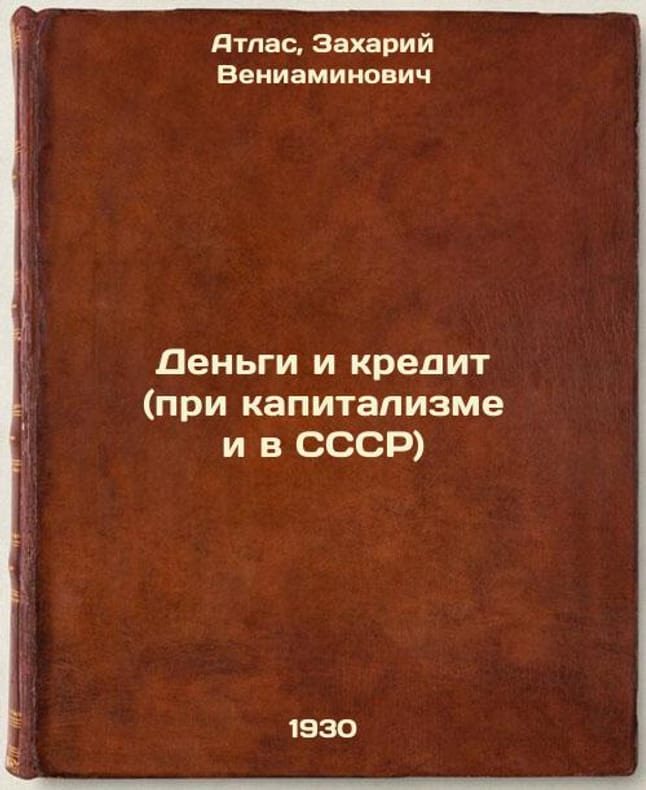
Atlas, Zakhary Veniaminovich
Den'gi i kredit (pri kapitalizme i v SSSR). In Russian /Money and credit (und...
"Short description: In Russian. Atlas, Zakhary Veniaminovich. Money and Credit (under Capitalism and in the USSR). Moscow; Leningrad: State Publishing House, 1930 (Moscow: type. The Red Proletarian ). Den'gi i kredit (pri kapitalizme i v SSSR). In Russian /Money and credit (under capitalism and in the USSR). The image is provided for reference only. It may reflect condition of one of the available copies or only help in identifying the edition. Please feel free to contact us for a detailed description of the copies available. SKU8992647"
书商的参考编号 : 8992647
|
|
|
ATLAS - BELLIN (Jacques Nicolas)
Description géographique des debouquemens qui sont au nord de l'isle de Saint Domingue avec des cartes et des plans des isles qui forment ces passages, et des dangers qui s'y trouvent. Pour le service des vaisseaux du Roy.
1768 1768 Imprimerie Didot, Paris, 1768. In/4 basane fauve marbrée, dos à nerfs orné d'ancres,152 p., page de titre gravée, 34 planches gravées (cartes) dont 15 rempliées,32 numerotées en continu,la 24 en double,et la carte des Isles Bermudes numerotée T1,N°48.Mouillure generale claire dans la marge superieure sur l’ensemble du volume,page de garde manquante. Armes sur le 2e plat,arrachées ou cachées sur le 1er plat.Coins usés.In-4 carré ( 250 X 195 mm. ) de: [5] ff. ( Titre, Titre gravé, Table des chapitres, Table des cartes et plans ), 152 pages, Joli bandeau allégorique signé Jean CHOFFARD et 34 cartes gravées dont 16 doubles ( 2 dépliantes ) par Nicolas BELLIN. Parmi les 34 cartes qui illustrent louvrage, une carte générale du Nord de St Domingue et de ses cinq débouquements, une du Canal de Bahama représentant le sud du Golfe du Mexique. Rare édition originale de ce routier des Antilles par le premier hydrographe de la Marine royale française, Jacques-Nicolas BELLIN ( 1703-1772 ). ( J. Polak 591 Sabbin, 4552 ).
书商的参考编号 : 20300
|
|
|
Atlas Des Soins
Donner Des Médicaments
Editions Vigot Reliure Rigide Illustrée Paris 1981 157 pages en format 23-27 cm - nombreuses illustrations
书商的参考编号 : 004327
|
|
|
Atlas, Galit
Emotional Inheritance
Short Books (2/2022)
书商的参考编号 : SVALIVCN-9781780725406
|
|
|
ATLAS ROUTIER ET TOURISTIQUE
ESPAGNE & PORTUGAL 2025 SPIRALE
MICHELIN
书商的参考编号 : SVBLIVCN-9782067265196
|
|
|
ATLAS ROUTIER
EUROPE 2025
MICHELIN
书商的参考编号 : SVBLIVCN-9782067265189
|
|
|
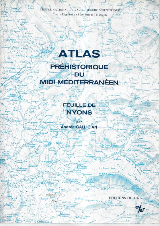
Atlas préhistorique du Midi méditerranéen
Feuille de Nyons
Bien complet de la carte Broché sans couverture illustrée Très bon Paris CNRS 1978 1 volume in-4°
书商的参考编号 : 13368
|
|
|
ATLAS TOPOGRAPHIQUE DE LA SUISSE
FLEURIER N°280
SERVICE TOPOGRAPHIQUE FEDERAL. Non daté. In-Folio. Broché. Etat d'usage, Couv. légèrement passée, Dos satisfaisant, Intérieur acceptable. Carte dépliante en 8 volets au 1/25.000e en couleurs.. . . . Classification Dewey : 912-Atlas, cartes et plans
书商的参考编号 : RO70123362
|
|
|
ATLAS ROUTIER ET TOURISTIQUE
FRANCE 2025 LE PRATIQUE
MICHELIN
书商的参考编号 : SVBLIVCN-9782067264991
|
|
|
ATLAS ROUTIER ET TOURISTIQUE
FRANCE 2025 1/200 000 SPIRALE
MICHELIN
书商的参考编号 : SVBLIVCN-9782067264977
|
|
|
ATLAS ROUTIER ET TOURISTIQUE
FRANCE 2025 PETIT FORMAT 1/350 000
MICHELIN
书商的参考编号 : SVBLIVCN-9782067264960
|
|
|
ATLAS ROUTIER ET TOURISTIQUE
FRANCE 2025 1/200 000
MICHELIN
书商的参考编号 : SVBLIVCN-9782067264984
|
|
|
ATLAS - Frans Houttuyn.
Geographische Oefening, Schetzende De Geheele Aardrykskunde In XXII. Landkaartjes, Naar De Nieuwste Ontdekkingen Gemaakt, En Opgehelderd By Wyze Van Vragen en Antwoorden; zeer nuttig voor de leerlingen en allerlei beminnaren van de geographie. vierde druk.
Amsterdam, Houttuyn,, 1778 Oorspronkelijke perkamenten binding, klein 8vo. (5) 190 pagina's,(18). met 22 handgekleurde, uitslaande gegraveerde en hand gekleurde kaarten. in prima conditie.
书商的参考编号 : 52453
|
|
|
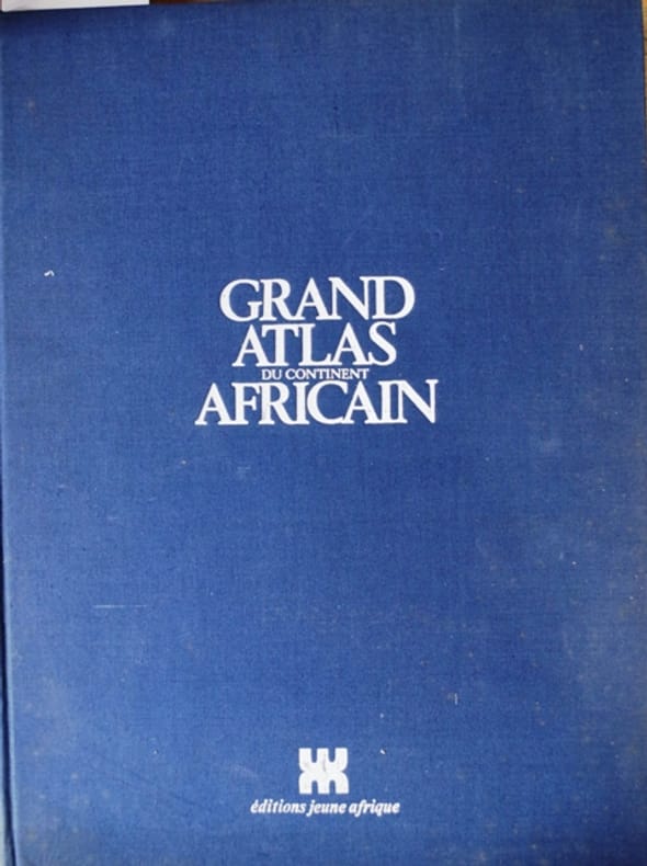
ATLAS
Grand atlas du continent africain.
Couverture rigide. Reliure toile de l'éditeur. 30 x 40 cm. 334 pages.
书商的参考编号 : 133665
|
|
|
ATLAS (Michèle). MONNIOT (Alain)
Guerlain. Les flacons à parfum depuis 1828.
Paris Milan 1997 In-4 (33 x 24,5 cm.), 317 pp. couverture cartonnée, jaquette. Nombreuses illustrations.
书商的参考编号 : 4930

|
|
|
ATLAS - CLOUET, l'ABBE (J.B.L.).
Géographie Moderne avec Introduction. Ouvrage utile a tous ceux qui veulent se perfectionner dans cette Science, on y trouve jusqu'aux notions les plus simples...Chaque Carte sur les marges l'explication de celle qu'elle renferme, la méthode qu'o...
Paris, Mondhare et jean, 1793. Small folio. (36x31 cm.). Cont. hcalf. Back somewhat rubbed and with some cracking along first hinges but tight and not loose. Engraved titlepage and engraved Table of maps (bound at end - bottom a little shawed). With 64 double-page engraved maps (the first 7 are hemispheres, world-systems etc), all handcoloured in outline. All maps have engraved text in borders. On good paper with only minor scattred brownspots in margins. (Plates numb. 1-64).
书商的参考编号 : 29054
|
|
|
ATLAS - STIELER, (A.).
Handatlas. Auswahl von 31 Karten.
Gotha, Justus Perthes, (Maps dated 1876). Folio.. Orig. full cloth, blindstamped and gilt frontboard. Corners bumped, edges worn, covers with scratches. (2) pp. and 31 steel-engraved double-page coloured maps. Light browning to lower margins of some maps, otherwise clean.
书商的参考编号 : 42075
|
|
|
ATLAS Magazine.-
Histoire, Archéologie Album N°3, Atlas N°9 à 12, réunion de 4 numéros dans sa reliure éditeur ilustrée.
P., 1961, in 8°, 146, 146, 146 et 146 pages.
书商的参考编号 : 49399
|
|
|
ATLAS NATIONAL
illustré des 86 départements et des possessions de la France, divisé par arrondissements, cantons et communes, avec le tracé de toutes les routes, chemins de fer et canaux.
Paris A. Combette 1856 In-folio, demi-veau noir, plats de papier noir estampés d'un motif à froid, titre de l'ouvrage poussé or au centre du premier plat; doublures et gardes de papier marbré (reliure de l'éditeur).Très bel atlas comportant une page de titre illustrée gravée, un tableau gravé donnant les statistiques de la France et de ses colonies, 92 cartes gravées rehaussées en couleurs (dont 86 cartes des départements et 6 cartes des colonies françaises), une mappemonde sur double page en couleurs, une carte de la France sur double page en couleurs, et 6 cartes rehaussées de couleurs donnant l'Europe, l'Afrique, l'Amérique méridionale, l'Amérique septentrionale, l'Asie, l'Océanie (100 cartes au total). Chaque carte est encadrée d'un décor figurant les paysages et les hommes célèbres des départements ou des régions.
书商的参考编号 : 52266
|
|
|
ATLAS ROUTIER ET TOURISTIQUE
ITALIE 1/300 000 ATLAS ROUTIER ET TOURISTIQUE
MICHELIN
书商的参考编号 : SVBLIVCN-9782067255074
|
|
|
ATLAS des ANCIENS PLANS de PARIS & ANDROUET du CERCEAU (Jacques).
La ville, cité, université de Paris.
[Paris, Imprimerie Nationale, circa 1552-1880]. En deux feuilles pouvant former un plan de 653 x 780 mm.
书商的参考编号 : LBW-3698

|
|
|
ATLAS P.L.M.
La Tunisie.
P., Barreau, sans date (vers 1900). Grand fascicule in 8 plats ornés en couleurs, 20 pp., carte centrale, deux hors texte en couleurs et des illustrations dans le texte.
书商的参考编号 : 4901
|
|
|
ATLAS TOPOGRAPHIQUE DE LA SUISSE
LA COTE AUX FEES FEUILLE N°282
SERVICE TOPOGRAPHIQUE FEDERAL. Non daté. In-Folio. Broché. Etat d'usage, Couv. légèrement passée, Dos satisfaisant, Intérieur acceptable. Carte dépliante en 8 volets au 1/25.000e en couleurs.. . . . Classification Dewey : 912-Atlas, cartes et plans
书商的参考编号 : RO70123361
|
|
|
Atlas
La cuisine de nos terroirs (150 recettes)
Atlas 2004 in4. 2004. Broché. 172 pages. Tous les amoureux de la bonne chère se laisseront guider par leurs souvenirs gourmands tout au long de cet ouvrage qui propose des recettes qui fleurent bon la campagne. En effet de l'entrée au dessert vous retrouverez les plats de nos grands-mères qui mijotaient et embaumaient la maison comme le potage Crécy la blanquette de lotte le rôti de magrets de canard le haricot de mouton le chou frisé à l'auvergnate ou encore le clafoutis aux cerises. Chaque recette est accompagnée de variantes des temps de préparation et de cuisson du coût de tours de main et aussi de vins conseillés. Ainsi un Saint-Emilion accompagnera parfaitement des cailles farcies ! Toutes ces recettes faciles à réaliser suivent les traditions régionales et populaires et rappellent le temps béni de l'enfance Bon Etat intérieur propre
书商的参考编号 : 170302
|
|
|
ATLAS du MONDE au XVIIe siècle par J. BLAEU.
Le grand atlas du Monde au XVIIe siècle. Choix de 100 cartes représentatives (sur 600 ) reprdouites en couleurs avec notices explicatives en français.
Paris, éditions Gründ 1992. Bel et gd in-folio (38x29) relié, 224 pages sur papier cartonné avec annexes.
书商的参考编号 : AUB-2569
|
|
|
ATLAS de Poche
Le Monde - Sa nouvele géographie politique, économique et humaine
Larousse. Non daté. In-18. Broché. Bon état, Couv. convenable, Dos satisfaisant, Intérieur frais. 64 p. - 25 cartes couleurs pleine page.. . . . Classification Dewey : 912-Atlas, cartes et plans
书商的参考编号 : ROD0028108
|
|
|
ATLAS
Le grand Livre Des Avions De Guerre : Les Bombardiers de La Seconde Guerre Mondiale
Paris Atlas 1996 In Quarto Photographies en couleurs , éclatés de l'avion et pages dépliantes. Histoire 2° Guerre Mondiale . - 170 p. , 1kg 300 gr.
书商的参考编号 : 015319

|
|
|
Atlas
Les doigts d'or Vins - Encyclopédie pratique des vins du monde [ Tomes 1 et 2 - complet ]
书商的参考编号 : 56517VPSL ???????? : 7255
|
|
|
ATLAS P.L.M.
Les Alpes Françaises : Savoie, Dauphiné.
1900 br. papier gauffré. plaq. in-4, 20pp., 1 carte et deux hors texte en couleurs de Job, P. PLM (ca. 1914)
书商的参考编号 : 16040
|
|
|
ATLAS CORINNE
LES RIVERAINS
HERODIOS EDITIONS
书商的参考编号 : SVBLIVCN-9782940666027
|
|
|
Atlas
Les avions de voltige et les pilotes de l'extrême
Atlas (Editions) 2006 In-4 relié 30,2 cm sur 24,2. 237 pages. atlas avions. Très bon état d’occasion.
书商的参考编号 : 56709
|
|
|
Atlas
Les motos de sport et de compétition
Glénat 2004 In-4 relié 29,2 cm sur 23. 236 pages. les motos. Bon état d’occasion.
书商的参考编号 : 56718
|
|
|
atlas
Les chasseurs americains
atlas 1990 In-4 relié 29,2 cm sur 22,2. Très bon état d’occasion.
书商的参考编号 : 71381
|
|
|
Atlas
Les bonnes saveurs : Soupes
Atlas 2008 160 pages 28x22x2cm. 2008. Broché. 160 pages.
书商的参考编号 : 98931

|
|
|
Atlas
Les motos de sport et de compétition
Glénat 2004 236 pages 29 2x23x2 6cm. 2004. Relié. 236 pages.
书商的参考编号 : 500099836

|
|
|
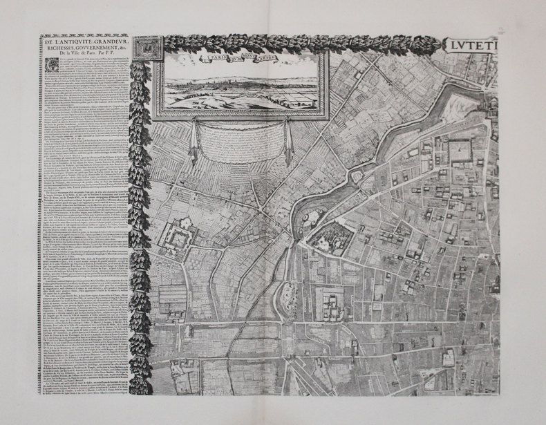
ATLAS des ANCIENS PLANS de PARIS & GOMBOUST (Jacques).
Lutetia - Paris.
[Paris, Imprimerie Nationale, 1652-1880]. En quatre feuilles pouvant être jointes pour former un plan d'environ 1,10 x 1,35 m.
书商的参考编号 : LBW-3292
|
|
|
Atlas
Mach 1 l'encyclopédie de l'aviation [No 65 de 1980]
Sans date.
书商的参考编号 : 300014652

|
|
|
Atlas
Mach 1 l'encyclopédie de l'aviation [No 72 de 1980]
Sans date.
书商的参考编号 : 300014658

|
|
|
ATLAS TOPOGRAPHIQUE DE LA SUISSE
MAUBORGET FEUILLE N°284
SERVICE TOPOGRAPHIQUE FEDERAL. Non daté. In-Folio. Broché. Etat d'usage, Couv. convenable, Dos satisfaisant, Intérieur acceptable. Carte dépliante en 8 volets au 1/25.000e en couleurs.. . . . Classification Dewey : 912-Atlas, cartes et plans
书商的参考编号 : RO70123364
|
|
|
ATLAS
New Atlas of Japan (shin nippon zucho), Motaharu Fujita Editor, december 1943, war departement Army Map service, Washnington DC
1 atlas in-8° br. à spirales, xxiii + 218 p. + 33 cartes dépliantes. Etiquettes et cachets de bibliothèque (ouvrages déclassés de bibliothèque), très bon état.
书商的参考编号 : 12001

|
|
|
ATLAS - ARROWSMITH, A.
Orbis Terrarum Veteribus Noti. A comparative Atlas of Ancient and Modern geography, from original Authorities, and upon a New Plan, for the use of Eton School.
London, Published by the Author, 1828. Large 4to. (35x29 cm.). Original worn hcalf, part of back lacks. Orig. printed paperlabel with title on frontboard. Sewing loosening. Engraved title, dedication-leaf a. Index-leaf. With 53 (all) engraved maps, handcoloured in outline. Marginal tears to the 3 first leaves. 3 maps with marginal tears, no loss. Some traces of use. Light scattered brownspotting. Maps loosening. (Maps numb. 1-26 (1-25 double-numb.)).
书商的参考编号 : 34844
|
|
|
ATLAS
Panorama géographique français, ou Les Mille et une beautés de la géographie de France, contenant la description de toutes les villes et principaux endroits de la France, avec leurs origine, étymologie, productions, curiosités, et les noms des hommes célèbres qui les ont illustrés, etc., etc. Orné de quatre-vingt-sept cartes, et de quatre-vingt-six vues des villes chef-lieux de chaque département ; ouvrage du plus grand intérêt pour les Français, de la plus grande utilité pour les étrangers qui voyagent en France, et très propre à être mis dans les mains de la jeunesse. Par une société de géographes
Paris Librairie d'éducation de A.-J. Sanson 1825 in-8 basane havane, dos lisse orné en long, filet et guirlande à froid encadrant les plats, fers de lycée poussé au centre du 1er plat [Institution Bellaguet-Muron], tranches marbrées [Rel. de l'époque]
书商的参考编号 : 27253
|
|
|
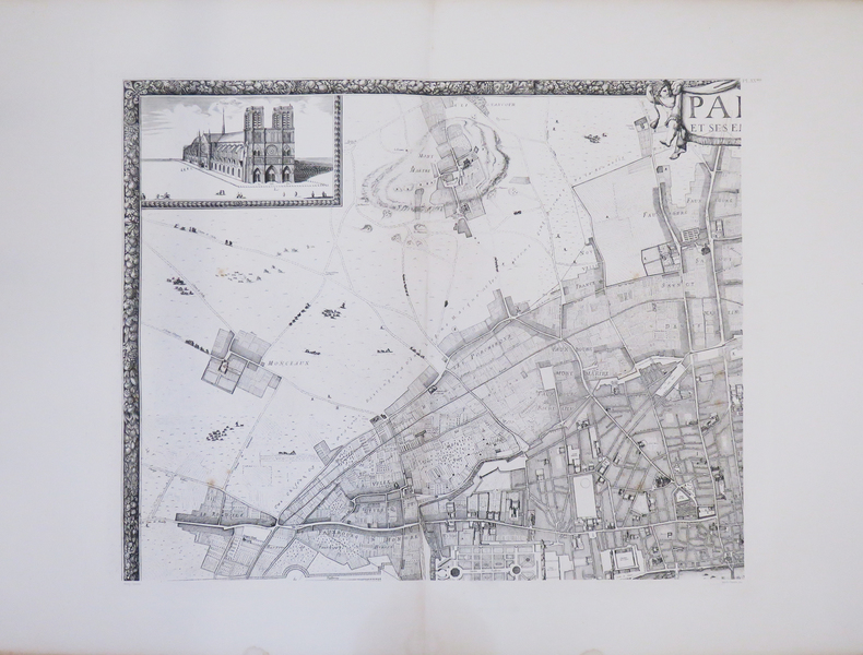
ATLAS des ANCIENS PLANS de PARIS & JOUVIN de ROCHEFORT (Albert).
Paris et ses environs.
[Paris, Imprimerie Nationale, 1672-1880]. En quatre feuilles pouvant former un plan d'environ 1,10 x 1,35 m.
书商的参考编号 : LBW-3268
|
|
|
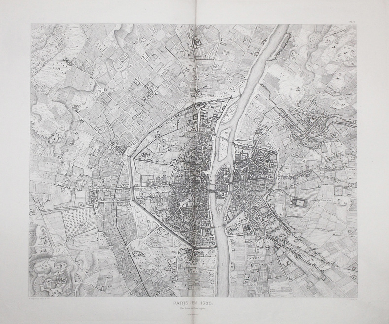
ATLAS des ANCIENS PLANS de PARIS & LEGRAND (Henri).
Paris en 1380.
[Paris, 1880]. 600 x 698 mm.
书商的参考编号 : LBW-3695
|
|
|
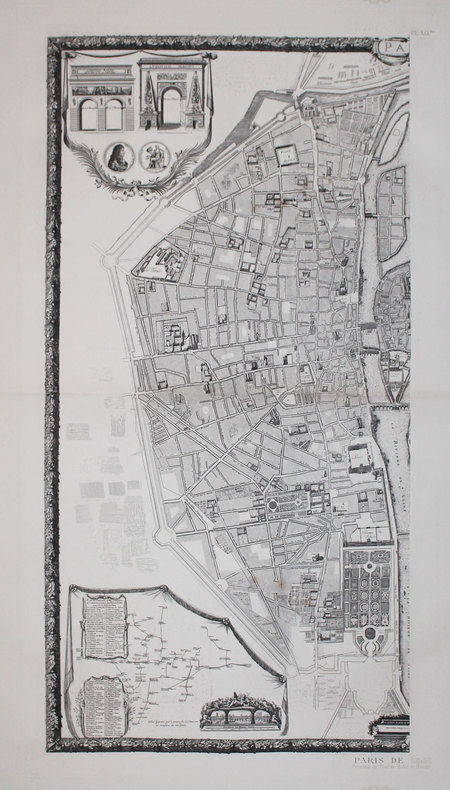
ATLAS des ANCIENS PLANS de PARIS & BULLET et BLONDEL.
Plan de Paris. Levé par les ordres du Roy. Et par les soins de Messieurs les Prévost des Marchands et Eschevins.
[Paris, Imprimerie Nationale, 1676-1880]. En deux feuilles pouvant former un plan d'environ 885 x 894 mm.
书商的参考编号 : LBW-3162
|
|
 ?????????
 ?????PDF???
 RSS feed


