|
Atlas Comics
Wild Comic Volume 1 Number 1 February 1954
Interstate Publishing 1954. First edition. Wraps. Good. moderate shelfwear tiny closed tears and chips to the cover protected in brodart sleeve. Includes illustrations. Interstate Publishing paperback
书商的参考编号 : Alibris.0079427
|
|
|
Atlas Computer Laboratory Science Research Council Great Britain
Computers in Number Theory: Symposium Proceedings
Academic Press Inc. Used - Good. Former Library book. Shows some signs of wear and may have some markings on the inside. Academic Press Inc unknown
书商的参考编号 : GRP12671457 ???????? : 0120657503 9780120657506
|
|
|
Atlas Contact
Native English for Nederlanders / druk 7: a personal cultural and grammatical guide
2005-09-04. Good. Ships with Tracking Number! INTERNATIONAL WORLDWIDE Shipping available. May not contain Access Codes or Supplements. May be re-issue. May be ex-library. Shipping & Handling by region. Buy with confidence excellent customer service! unknown
书商的参考编号 : 9047000501 ???????? : 9047000501 9789047000501

|
|
|
Atlas Copco MCT
BELLES AFFICHES DU CINEMA LES 1910-1949
Paris: Editions Atlas 1986. 160 pages. Silver lettering on the spine silver decoration on the front cover. Cover corners are lightly bumped edges are lightly shelf worn . Dust jacket is protected in Brodart has minor wear along the edges. A very good copy of this book featuring early movie posters. Illustrated throughout with reproductions of the posters in full colour. Text is in French. This is a heavy book and will require additional shipping charges. . Not Stated Presumed First Edition. Black Cloth Hardcover. Very Good/Very Good . 8.5 x 11.5. Movie Posters History. Editions Atlas Hardcover
书商的参考编号 : 006301 ???????? : 2731204869 9782731204865
|
|
|
ATLAS CORINNE
LES RIVERAINS
HERODIOS EDITIONS
书商的参考编号 : SVBLIVCN-9782940666027
|
|
|
ATLAS Cram George F.
Cram's Superior Atlas of the World Indexed. Cover title: Cram's Superior Family Atlas. The World.
New York.: Cram. 1901. Numerous full page and double page color maps almost all of which are tipped-in decorative endpapers 3 color plates black and white illustrations all edges gilt 562 pp index 15 x 12 inches half-leather covered boards with gilt lettering hardbound. Extremities of cover very worn with some loss to backstrip tape residue on backstrip boards exposed at corners some loss to leather on rear from insect damage otherwise a few small nicks and spots to cover interior clean and in fine condition. Most double page maps are one sheet tipped in. One of the particular pleasures of this large atlas is the full page maps of over 40 American cities two three or four color. These are as listed in the table of contents: Greater New York Boston divided two sheets New York City Double Brooklyn Buffalo Philadelphia Double Baltimore Washington Pittsburgh and Allegheny Double Richmond and Manchester Cincinnati Columbus Cleveland Toledo Indianapolis Detroit Double Chicago St. Louis Kansas City St. Joseph Council Bluffs Omaha Denver Milwaukee Minneapolis St. Paul Louisville Memphis Nashville Atlanta Birmingham New Orleans Dallas San Francisco double Seattle Sacramento Los Angeles San Diego Portland Or. divided two sheet Tacoma and in Canada Quebec Montreal and Toronto. Half page maps in color of Springfield Worcester Lynn and Lowell Ma. The map section is from page 10 to page 231 and is followed by text with historical information. there is a handsome color frontispiece of the Flags of the Union followed by another frontispiece a black and white photo-illustration of the San Francisco Call Building. Clean clear maps give a thorough picture of the United States and the world at the turn of the twentieth century. . Cram. hardcover
书商的参考编号 : 35928

|
|
|
ATLAS DE BATIMENTS MILITAIRES, INFANTERIE -
Place d'Anvers. Front 7-8.
No. place, no date, ca. 1880. Imperial folio. (72 x 49,5 cm.). Contemp. full cloth. Titlelabel with gilt lettering on upper cover. Containing 9 double-folio plates printed in blue, each measuring 70 x 94 cm.
书商的参考编号 : 59333
|
|
|
ATLAS de GEOGRAPHIE par ANDREES.
Allgemeiner Handatlas in 126 Haupt- und 137 Nebenkarten nebst vollständigem Namenverzeichnis herausgeben von A. SCOBEL.
Verlag von Velhagen & Klasing 1899. Bon exemplaire relié, gd et fort in-4, cartes montées sur onglets. Dos manque. Réparation de plusieurs cartes.
书商的参考编号 : AUB-6214
|
|
|
Atlas de géographie militaire
Atlas de géographie militaire. ... pour l'École Impériale militaire de Saint-Cyr
Paris, Jouvet et Cie 1886 In-folio 46 x 32 cm. Cartonnage éditeur percaline rouge, plats biseautés, report du titre doré sur le dos et le premier plat de couverture, 42 cartes en couleurs sur double page montées sur onglets, table des cartes composant l’atlas. Cartonnage terni, premier mors fendillé, dos restauré, intérieur en bon état et assez frais.
书商的参考编号 : 125785
|
|
|
ATLAS DE l'ARCHEOLOGIE DU NORD.
Representent des Echantillons de L'Age de Bronze et de L'Age de Fer/ Atlas for Nordisk Oldkyndighed.publi� par la Soci�t� Royale des Antiquares du Nord.
Copenhague Thiele 1857. Folio. Orig. hcloth. A tear to fronthinge on lower part of spine. 10 pp. 22 engraved plates with many figs. Some plates loosening. Internally clean. hardcover
书商的参考编号 : 58128
|
|
|
ATLAS DE MARSEILLE)
Atlas des paroisses du diocèse de Marseille. Document de travail hors commerce contenant le texte des circonscriptions paroissiales promulgué le 15 janvier 1980 par le cardinal-archevêque.
Marseille, Centre Diocésain d'Etudes Sociologiques, 1980. In-4 broché (21 x 30 cm).
书商的参考编号 : 23623

|
|
|
ATLAS de Poche
Le Monde - Sa nouvele géographie politique, économique et humaine
Larousse. Non daté. In-18. Broché. Bon état, Couv. convenable, Dos satisfaisant, Intérieur frais. 64 p. - 25 cartes couleurs pleine page.. . . . Classification Dewey : 912-Atlas, cartes et plans
书商的参考编号 : ROD0028108
|
|
|
Atlas der Anatomie des Menschen . M?nchen Berlin Wien
Atlas der Anatomie des Menschen . - Mnchen Berlin Wien
n/a. Used - Good. Former Library book. Shows some signs of wear and may have some markings on the inside. n/a unknown
书商的参考编号 : GRP113972194 ???????? : 3541028270 9783541028276
|
|
|
Atlas der Steiermark
Herausgegeben von der Steiermärkischen Landesregierung unter Mitarbeit des Naturwissenschaftlichen Vereines für Steiermark. Wissenschaftliche und kartographische Redaktion Manfred Straka. Atlas u. Textband in 2 Bänden.
Graz, Akademische Druck- u. Verlagsanstalt, (1953-1970). Qu.-Gr.-Fol. 3 Textbll. u. 94 meist farb., tlw. gefalt. Karten, Diagrammen usw., OHLwd.-Ringbuchmappe m. goldgepr. Wappen u. Titel a. Vorderdeckel.
书商的参考编号 : 43601
|
|
|
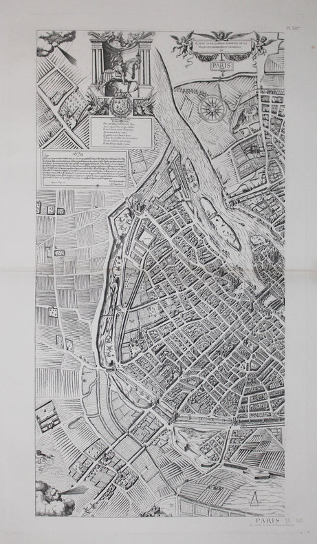
ATLAS des ANCIENS PLANS de PARIS & ANDROUET du CERCEAU (Jacques).
La ville, cité, université de Paris.
[Paris, Imprimerie Nationale, circa 1552-1880]. En deux feuilles pouvant former un plan de 653 x 780 mm.
书商的参考编号 : LBW-3698

|
|
|
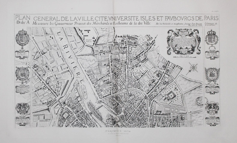
ATLAS des ANCIENS PLANS de PARIS & BOISSEAU (Jean).
Plan général de la ville, cité, université, isles et faubourgs de Paris.
[Paris, Imprimerie Nationale, 1648-1880]. En deux feuilles pouvant former un plan d'environ 760 x 744 mm.
书商的参考编号 : LBW-3693
|
|
|
ATLAS des ANCIENS PLANS de PARIS & BULLET et BLONDEL.
Plan de Paris. Levé par les ordres du Roy. Et par les soins de Messieurs les Prévost des Marchands et Eschevins.
[Paris, Imprimerie Nationale, 1676-1880]. En deux feuilles pouvant former un plan d'environ 885 x 894 mm.
书商的参考编号 : LBW-3162
|
|
|
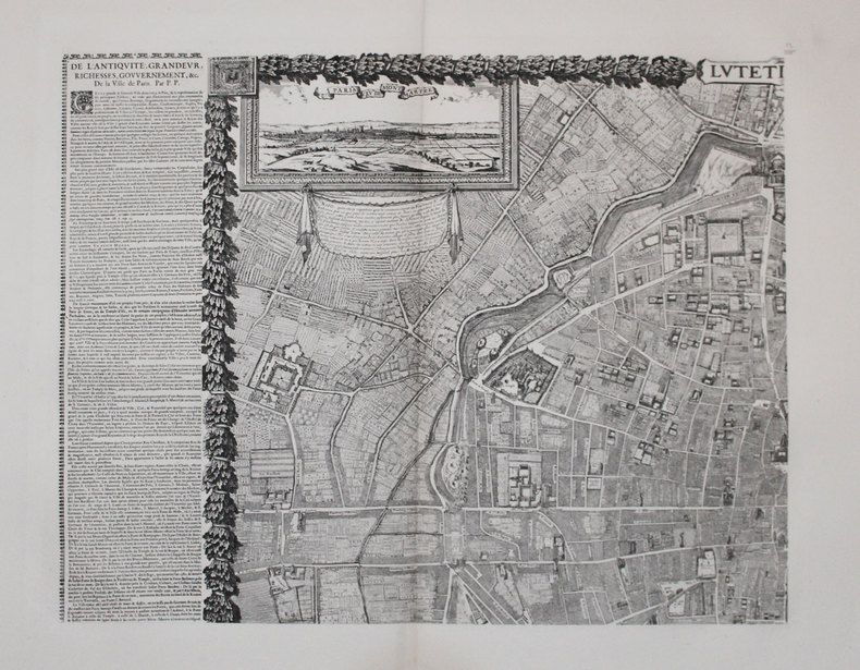
ATLAS des ANCIENS PLANS de PARIS & GOMBOUST (Jacques).
Lutetia - Paris.
[Paris, Imprimerie Nationale, 1652-1880]. En quatre feuilles pouvant être jointes pour former un plan d'environ 1,10 x 1,35 m.
书商的参考编号 : LBW-3292
|
|
|
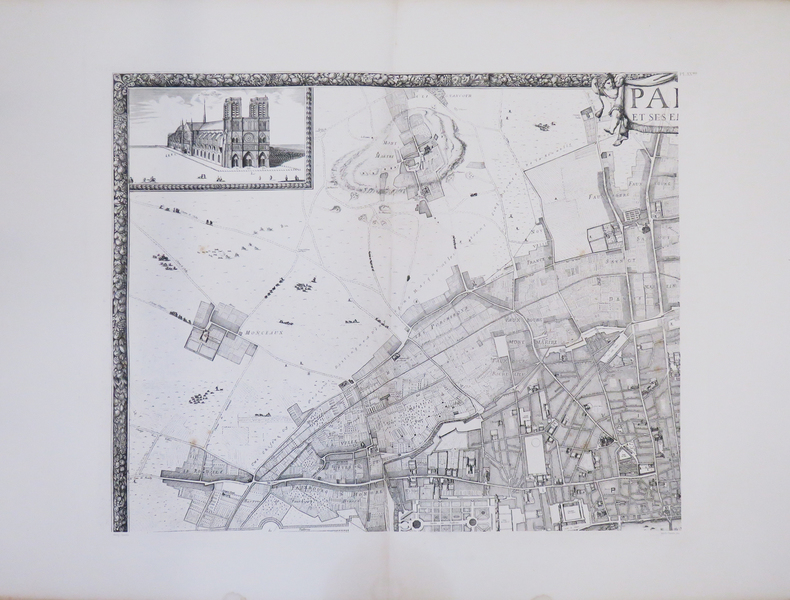
ATLAS des ANCIENS PLANS de PARIS & JOUVIN de ROCHEFORT (Albert).
Paris et ses environs.
[Paris, Imprimerie Nationale, 1672-1880]. En quatre feuilles pouvant former un plan d'environ 1,10 x 1,35 m.
书商的参考编号 : LBW-3268
|
|
|
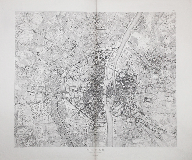
ATLAS des ANCIENS PLANS de PARIS & LEGRAND (Henri).
Paris en 1380.
[Paris, 1880]. 600 x 698 mm.
书商的参考编号 : LBW-3695
|
|
|
ATLAS des ANCIENS PLANS de PARIS & QUESNEL (François).
Carte ou description nouvelle de la ville, cité, universitée, et fauxbours de Paris. 1609.
[Paris, Imprimerie Nationale, 1609-1880]. En deux feuilles pouvant former un plan d'environ 872 x 890 mm.
书商的参考编号 : LBW-3696
|
|
|
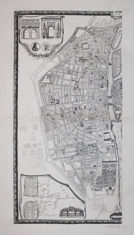
ATLAS des ANCIENS PLANS de PARIS & VERNIQUET (Edme).
Plan de la ville de Paris avec sa nouvelle enceinte. Levé géométriquement sur la méridienne de l'Observatoire. Par le C.en Verniquet. Parachevé en 1791. Dessiné et gravé par les C.ens P.T. Bartholomé, et A.J. Mathieu.
[Paris, Imprimerie Nationale, 1799-1880]. En six feuilles pouvant former un plan d'environ 1,41 x 1,65 m.
书商的参考编号 : LBW-3189
|
|
|
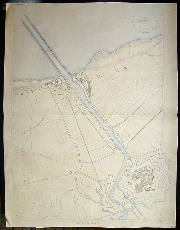
Atlas des ports de France -
Port de Gravelines -
Grand plan (55x80,6cm) détaillé, à l'échelle 1/5000ème, publié dans l'Atlas des ports de France, en 1874 - gravé par Dulos - Exemplaire avec une pliure centrale, 2 coins légèrement cornés, sans atteinte à la carte, sinon bon état, aquarellé à l'époque -
书商的参考编号 : 37075
|
|
|
ATLAS des PORTS de FRANCE.
[ALGÉRIE/ARZEW] Port d'Arzew.
1889. 415 x 556 mm.
书商的参考编号 : LBW-4916

|
|
|
ATLAS des PORTS de FRANCE.
[ALGÉRIE/BENI SAF] Port de Beni-Saf.
1889. 406 x 548 mm.
书商的参考编号 : LBW-4914

|
|
|
ATLAS des PORTS de FRANCE.
[ALGÉRIE/DELLYS] Port de Dellys.
1891. 571 x 358 mm.
书商的参考编号 : LBW-4918

|
|
|
ATLAS des PORTS de FRANCE.
[ALGÉRIE/GHAZAOUET & MERS-EL-KÉBIR] I. Nemours - II. Mers-El-Kébir.
1888. 580 x 383 mm.
书商的参考编号 : LBW-4913

|
|
|
ATLAS des PORTS de FRANCE.
[ALGÉRIE/JILEL] Port de Djidjelli.
1890. 386 x 539 mm.
书商的参考编号 : LBW-4921

|
|
|
ATLAS des PORTS de FRANCE.
[ALGÉRIE/STORA & SKIKDA] I. Stora - II. Philippeville - III. Carte de la baie de Philippeville.
1892. 587 x 840 mm.
书商的参考编号 : LBW-4923

|
|
|
ATLAS des PORTS de FRANCE.
[ALGÉRIE/TÉNÈS] Port de Ténès.
1889. 577 x 372 mm.
书商的参考编号 : LBW-4917

|
|
|
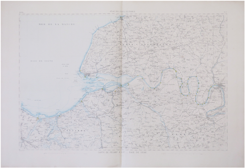
ATLAS des PORTS de FRANCE.
[BAIE de SEINE] Carte de Fécamp à Luc. - Baie de Seine.
1878 573 x 827 mm.
书商的参考编号 : LBW-6766
|
|
|
ATLAS des PORTS de FRANCE.
[BASSIN d'ARCACHON] Bassin d'Arcachon et port de la Teste-de-Buch.
1886. 578 x 372 mm ; sous cadre.
书商的参考编号 : LBW-7833

|
|
|
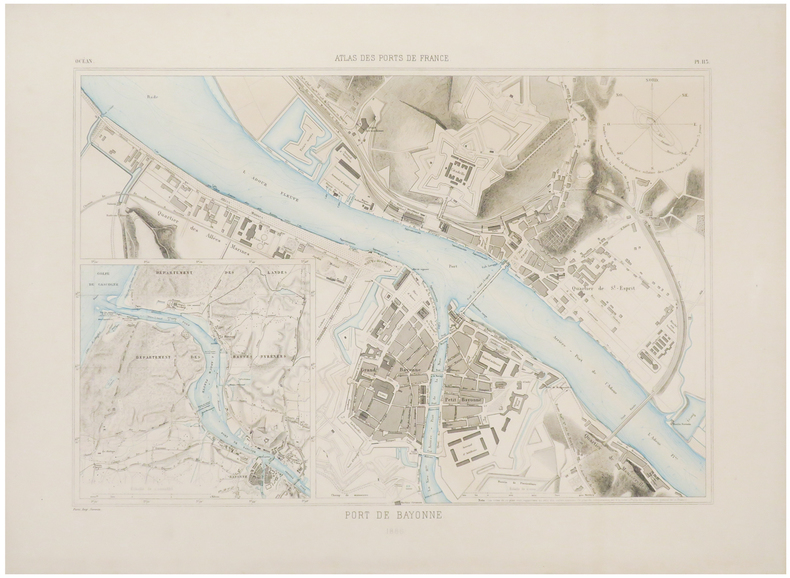
ATLAS des PORTS de FRANCE.
[BAYONNE] Port de Bayonne.
1886. 405 x 537 mm.
书商的参考编号 : LBW-6656
|
|
|
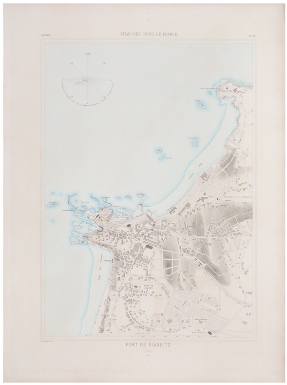
ATLAS des PORTS de FRANCE.
[BIARRITZ] Port de Biarritz.
1885. 558 x 378 mm.
书商的参考编号 : LBW-6670
|
|
|
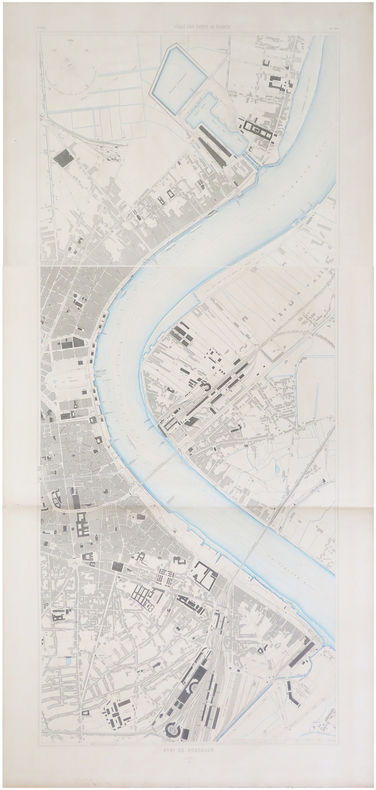
ATLAS des PORTS de FRANCE.
[BORDEAUX] Port de Bordeaux.
1886. En deux feuilles pouvant être jointes pour former un plan de 1,28 x 0,54 m.
书商的参考编号 : LBW-6672
|
|
|
ATLAS des PORTS de FRANCE.
[BOULOGNE-sur-MER] Port de Boulogne.
1872. 415 x 533 mm.
书商的参考编号 : LBW-6762

|
|
|
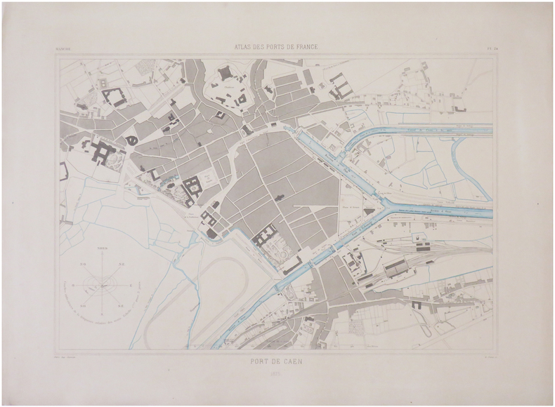
ATLAS des PORTS de FRANCE.
[CAEN] Port de Caen.
1875. 395 x 528 mm.
书商的参考编号 : LBW-6759
|
|
|
ATLAS des PORTS de FRANCE.
[CALAIS] Port de Calais.
1872. 565 x 358 mm.
书商的参考编号 : LBW-6768

|
|
|
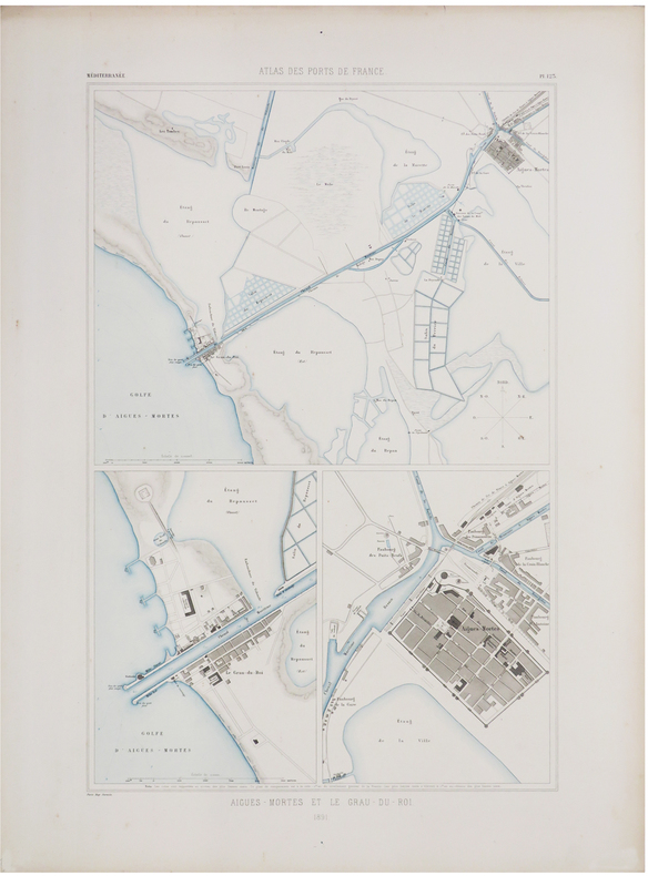
ATLAS des PORTS de FRANCE.
[CAMARGUE] Aigues-Mortes et Le Grau-du-Roi.
1891. 570 x 356 mm.
书商的参考编号 : LBW-6498
|
|
|
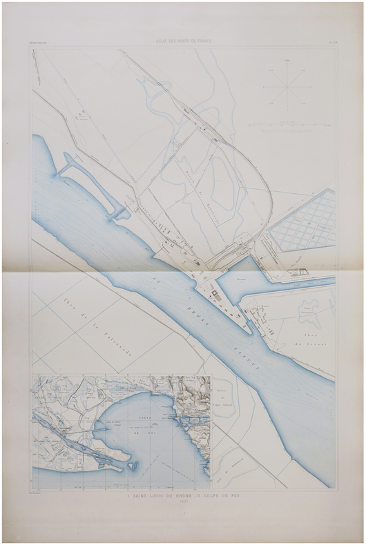
ATLAS des PORTS de FRANCE.
[CAMARGUE] I. Saint-Louis-du-Rhône. - II. Golfe de Fos.
1893. 840 x 560 mm.
书商的参考编号 : LBW-6774
|
|
|
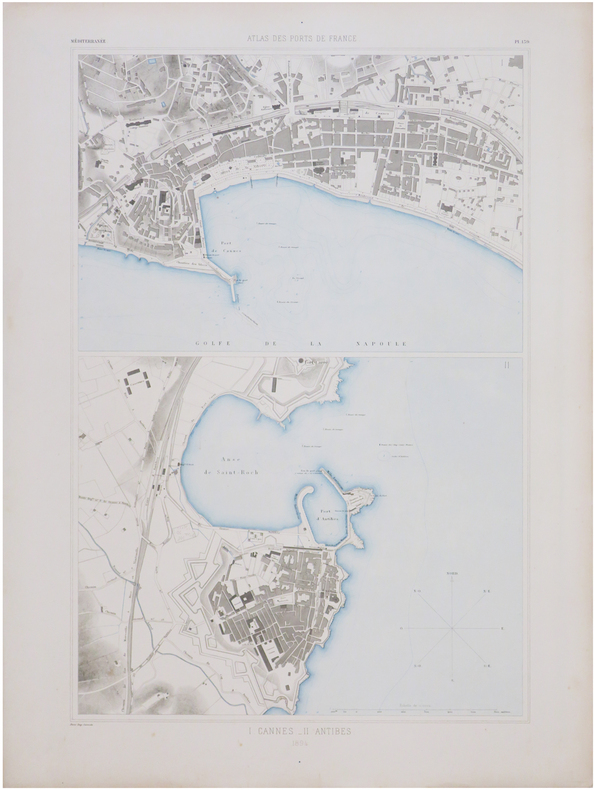
ATLAS des PORTS de FRANCE.
[CANNES & ANTIBES] I. Cannes. - II. Antibes.
1894. 593 x 382 mm.
书商的参考编号 : LBW-6764
|
|
|
ATLAS des PORTS de FRANCE.
[CHERBOURG] Port de Cherbourg.
1878. 846 x 537 mm.
书商的参考编号 : LBW-6679

|
|
|
ATLAS des PORTS de FRANCE.
[CORSE/AJACCIO] Port d'Ajaccio.
1889. 568 x 362 mm.
书商的参考编号 : LBW-6757

|
|
|
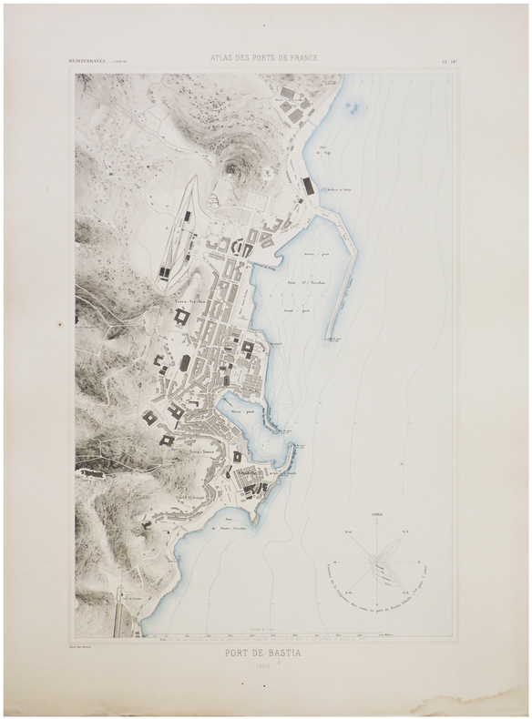
ATLAS des PORTS de FRANCE.
[CORSE/BASTIA] Port de Bastia.
1889. 555 x 358 mm.
书商的参考编号 : LBW-6753
|
|
|
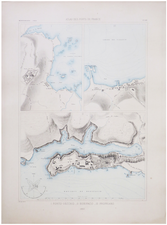
ATLAS des PORTS de FRANCE.
[CORSE/PORTO-VECCHIO] I. Porto-Vecchio. - II. Bonifacio. - III. Propriano.
1888. 568 x 380 mm.
书商的参考编号 : LBW-6773
|
|
|
ATLAS des PORTS de FRANCE.
[CORSE/SAINT-FLORENT] I. Saint-Florent. - II. Centuri. - III. Tollari. - IV. Barcaggio. - V. Macinaggio. - VI. Luri. - VII. Porticciolo. - VIII. Erbalunga.
1888. 566 x 355 mm.
书商的参考编号 : LBW-6756

|
|
|
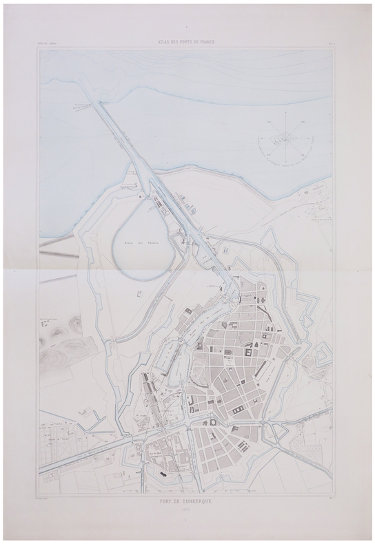
ATLAS des PORTS de FRANCE.
[DUNKERQUE] Port de Dunkerque.
1873. 843 x 530 mm.
书商的参考编号 : LBW-6755
|
|
|
ATLAS des PORTS de FRANCE.
[FOURAS] Port de Fouras.
1882. 575 x 370 mm.
书商的参考编号 : LBW-6770

|
|
|
ATLAS des PORTS de FRANCE.
[HONFLEUR] Port de Honfleur.
1875. 395 x 531 mm.
书商的参考编号 : LBW-6778

|
|
|
ATLAS des PORTS de FRANCE.
[LA ROCHELLE] Port de La Rochelle.
1885. 857 x 547 mm.
书商的参考编号 : LBW-6661

|
|
 ?????????
 ?????PDF???
 RSS feed


