|
|
|
Dutton, Leonard
THE ANGLO-SAXON KINGDOMS The Power Struggles from Hengist to Eggberht
SPA in Conjunction With L. Dutton. Fine in Near Fine dust jacket. 1993. Hardcover. 1854211978 . Dustjacket is protected in plastic sleeve. ; 9.2 X 6.6 X 1.1 inches; 290 pages . SPA, in Conjunction With L. Dutton hardcover
书商的参考编号 : 34836 ???????? : 1854211978 9781854211972
|
|
|
Dutton, Ralph & Holden, Lord
THE LAND OF FRANCE
London: B. T. Batsford Ltd. Very Good. 1949. Third Edition. Hardcover. Boards lightly bowed; Published just on the eve of WWII then revised immediately after hostilites ceased then again for this edition in 1949. The authors kept much of the prewar flavor but updated other information ; B&W Photographs; 8vo; 152 pages . B. T. Batsford Ltd. hardcover
书商的参考编号 : 16048
|
|
|
Duun, Olav
Ragnhild : e. Roman-Trilogie / aus d. norweg. Landsmaal übertr. von S. Angermann.
Hamburg : Claassen & Goverts, 1948. 547 S. Titelbild d. Autors gegenüber d. Titelseite montiert (Orig.?). 8°. OPpbd.
书商的参考编号 : 10237
|
|
|
Duun, Olav
Samtid
Oslo: Olaf Norlis Forlag 1936 WYSIWYG pricing--no added shipping charge for standard shipping within USA. Full pumpkin cloth gilt titles & device 239 pp. Spine cocked gift inscription dated 1936 on ffep. DJ spine browned rear panel foxed; in Brodart archival cover. Presumed first edition because title page date gift inscription and copyright date match Olaf Norlis is the copyright holder and no additional printings are noted. Norwegian language novel. Shipping weight 2 lbs. International 1 lb. 8 oz. . VG/VG-. 19 X 13 cm. Olaf Norlis Forlag Hardcover
书商的参考编号 : LANR00036

|
|
|
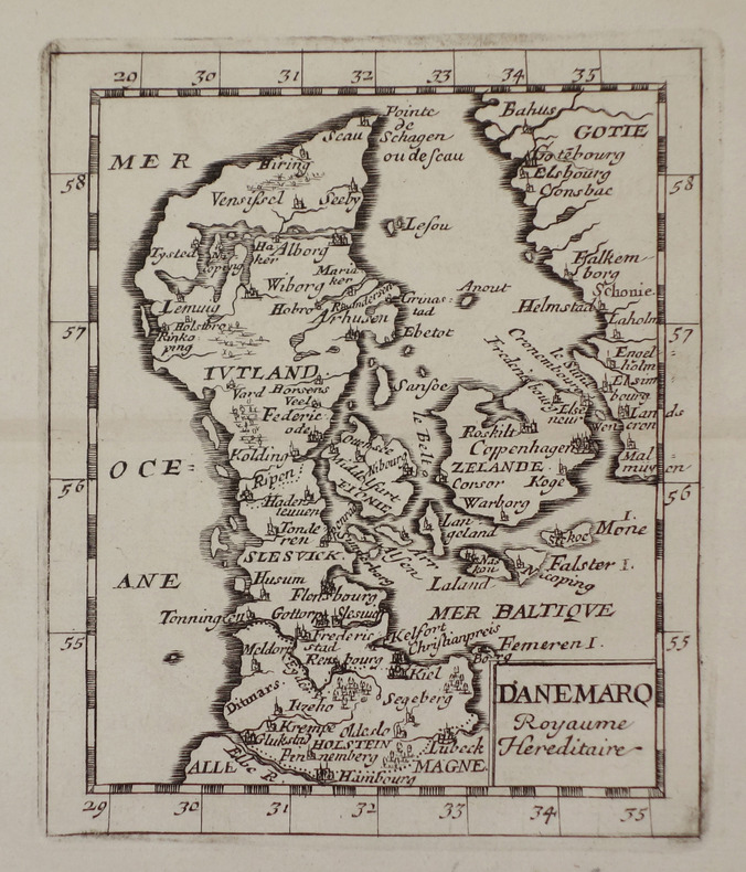
DUVAL (Pierre).
[DANEMARK] Danemarq royaume héréditaire.
[1661]. 127 x 104 mm.
书商的参考编号 : LBW02536
|
|
|
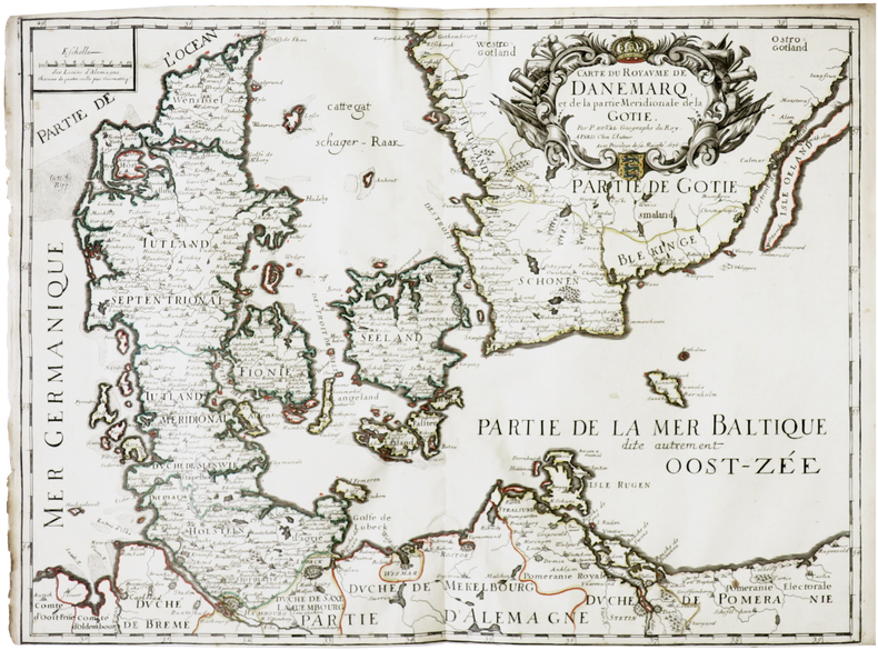
DUVAL (Pierre).
[DANEMARK] Carte du royaume de Danemarq, et de la partie méridionale de la Gotie.
Paris, chez l'auteur, 1676 [1677]. 403 x 547 mm.
书商的参考编号 : LBW-7311
|
|
|
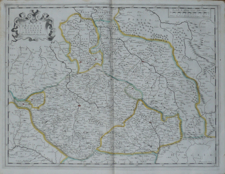
DUVAL (Pierre);
[REPUBLIQUE TCHEQUE] Carte de Bohême Moravie Silésie et Lusace.
Paris Pierre Mariette 1654 405 x 532 mm.
书商的参考编号 : LBW-1475
|
|
|
DUVAL (Pierre).
[ROUMANIE] Transilvanie, Valaquie et Moldavie.
[1661]. 103 x 130 mm.
书商的参考编号 : LBW0253a
|
|
|
DUVAL (Pierre).
[SUEDE] La Suède et tous les estats qui en dépendent.
[1661]. 126 x 105 mm.
书商的参考编号 : LBW02535
|
|
|
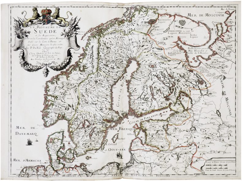
DUVAL (Pierre).
[SUÈDE] Le Royaume de Suède et ses acquisitions, tant en la Scandinavie qu'en Alemagne.
Paris, chez l'autheur, 1676 [1677]. 398 x 536 mm.
书商的参考编号 : LBW-7312
|
|
|
DUVAL (Pierre).
Angleterre.
[1661]. 99 x 121 mm.
书商的参考编号 : LBW02532
|
|
|
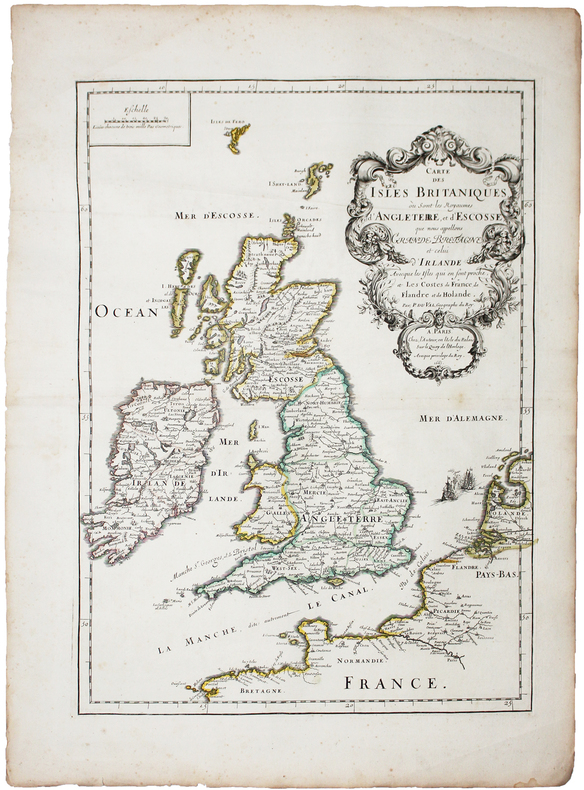
DUVAL (Pierre).
Carte des Isles Britaniques où sont les Royaumes d'Angleterre, et d'Escosse, que nous appellons Grande Bretagne et celui d'Irlande avecque les isles qui en sont proche, et les costes de France, de Flandre et de Holande.
Paris, chez l'auteur, 1665. 473 x 344 mm.
书商的参考编号 : LBW-5194
|
|
|
DUVAL (Pierre).
Escosse.
[1661]. 102 x 125 mm.
书商的参考编号 : LBW02531
|
|
|
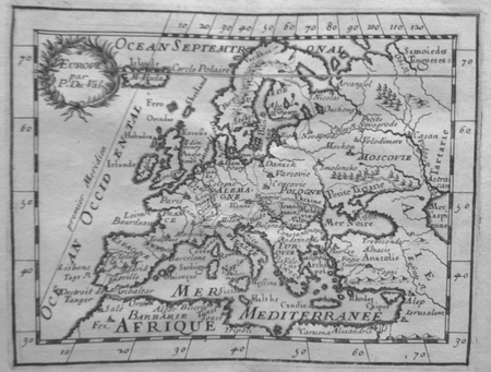
DUVAL (Pierre).
Europe.
[1661]. 105 x 137 mm.
书商的参考编号 : LBW027b9
|
|
|
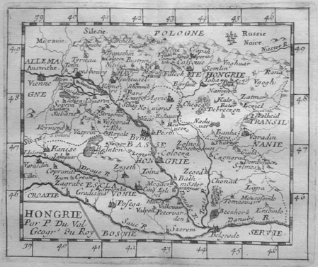
DUVAL (Pierre).
Hongrie.
[1661. 106 x 130 mm.
书商的参考编号 : LBW027bf
|
|
|
DUVAL (Pierre).
Isles Britanniques.
[1661]. 100 x 123 mm.
书商的参考编号 : LBW02530
|
|
|
DUVAL (Pierre).
L'Italie.
[1661]. 102 x 125 mm.
书商的参考编号 : LBW02533
|
|
|
DUVAL (Pierre);
Turquie en Europe.
1661 106 x 128 mm.
书商的参考编号 : LBW02538
|
|
|
DUVERNEY (Jacques)
Un tour en Suisse. Histoire, science, monuments, paysages
Tours, A. Mame, 1886-gr. in-8 : 368 pp. ; ill. par Karl Girardet (piqûres et / ou rousseurs) - cart. édit. abondamment orné, toile rouge, tr. dorées
书商的参考编号 : 281
|
|
|
DUVERNEY Jacques
Un tour en Suisse. Histoire, science, monuments, paysages. Illustrations par Karl Girardet.
,Tours, Alfred Mame et Fils, éditeurs 1866, 328+315 pp., 2 vol. in 12 reliés pleine percaline bleue, dos lisses ornés de motifs dorés, titres dorés, un fleuron doré central sur chaque premier plat (reliure éditeur). 24 planches hors-texte en xylogravure dessinées par Karl Girardet: Morgarten, Bâle, Chute du Rhin, Cathédrale de Constance, Source du Rhin, Zürich, Einsiedeln, Eboulement de Goldau, Rigi vu de Lucerne, Le lion de Lucerne, Gersau, Intérieur de chalet, Défilé de Dazio-Grande, Environs de Gutlanen, Cathédrale de Milan, Village des Bains de Louèche, Lac de Dauben sur la Gemmi, Le Staubbach, Brienz, Fribourg, Lausanne, Le Mont-Blanc et Chamounix, La Tête-Noire, Château de Chillon. Bel exemplaire.
书商的参考编号 : 16576

|
|
|
DUVAL Pierre (1618 - 1683)
Archeveschez et eveschez d'Allemagne
Rara carta geografica tratta dall'atlante ecclesiastico del Duval dal titolo "Le monde christien ou sont les cartes des archeveschez et des eveschez de l''univers" edito a Parigi, presso l'autore stesso, nel 1662. Incisione in rame, coloritura coeva dei contorni, in ottimo stato di conservazione. A very rare map, taken from "Le monde christien ou sont les cartes des archeveschez et des eveschez de l''univers", the ecclesiastical atlas published in Paris in 1662 by the author Pierre Duval. Copper engraving, original outline coulors, in good condition. Shirley T. Duv 1a, Pastoreau Duval XII, Phillips 3301.

|
|
|
DUVAL Pierre (1618 - 1683)
Archeveschez et Eveschez Schismatiques de Moscovie
Rara carta geografica tratta dall'atlante ecclesiastico del Duval dal titolo "Le monde christien ou sont les cartes des archeveschez et des eveschez de l''univers" edito a Parigi, presso l'autore stesso, nel 1662. Incisione in rame, coloritura coeva dei contorni, in ottimo stato di conservazione. A very rare map, taken from "Le monde christien ou sont les cartes des archeveschez et des eveschez de l''univers", the ecclesiastical atlas published in Paris in 1662 by the author Pierre Duval. Copper engraving, original outline coulors, in good condition. Shirley T. Duv 1a, Pastoreau Duval XII, Phillips 3301.

|
|
|
DUVAL Pierre (1618 - 1683)
L'Europe
Acquaforte, 1656 circa, con coloritura coeva dei contorni, in buone condizioni.Esemplare del secondo stato di due, con l’imprint di Jacques Lagniet e la data del 1661.La mappa proviene dal rarissimo foglio intitolato “L’Europe par P. Du Val Geographe du Roy”, dal quale è stato ritagliato all’epoca - come anche certificato dalle antiche iscrizioni a inchiostro su alcune delle mappe - venendo applicato su un supporto di carta contemporanea, a formare un piccolo atlante in-sedicesimo oblungo.Non abbiamo trovato bibliografia su questo foglio d’Europa, pertanto ci riferiamo alla scarsa letteratura sui fogli che rappresentano gli altri continenti.Secondo Philip Burden (che descrive la carta dell’America), lo scopo di questa rara curiosità cartografica di Pierre Duval non è noto. Fa parte di un insieme di quattro tavole raffiguranti i continenti. Può essere datato, per motivi cartografici, all’incirca nel 1656. Burden descrive un solo esemplare di primo stato e due prove con l’indirizzo di Lagniet.La mappa dell'Asia è stata recentemente descritta da Jason Hubbard, che elenca un solo esemplare di primo stato e 5 di secondo (cfr. Japoniae Insulae, The Mapping of Japan, p. 201).Richard Betz descrive 3 stati del foglio dell’Africa: senza la data, con l’imprint di Jacques Lagniet e la data del 1661, e con tracce di cancellazione sui suoi indirizzi (cfr Betz, The Mapping of Africa, pp. 294, 295). Elenca un solo esemplare di primo stato, tre copie di quello stampato da Lagniet e tre del foglio con l’indirizzo abraso. Di un secondo stato del foglio del continente europeo, siamo stati di censire solo l’esemplare conservato presso la Bibliotheque National de France, unica istituzione che vanta nella propria raccolta tutti e quattro i fogli dei continenti di Pierre Duval e Jacques Lagniet. Etching, circa 1656, with contemporary outline colour, good condition.Example of the second state, with the imprint of Jacques Lagniet and the date 1661.The map comes from the very rare sheet entitled “L’Europe Par le Sieur Du Val Geographe Ord. du Roy”, from which it was cut at the time and laid down on contemporary laid paper support, to form a small atlas, as certified by the ancient ink inscriptions on some of the maps.We have not found bibliography on this sheet of Europe, we therefore refer to the scarce literature on the sheets representing the other continents.According with Philip Burden “The purpose of this rare curiosity by Pierre Duval is not known. It forms part of a set of the four known continents. It can be dated to apporximately 1656 […] The second state bears the additional imprint of Jacques Lagniet and the date 1661” (cf. Burden, The Mapping of North America, pp. 417-418, n. 322). The map of Asia is recently described by Jason Hubbard: “This miniature map of Japan is on a sheet of maps of Asia. Besides the map of the Asian continent there are 17 detailed maps including Turkey, the Holy Land, Georgia and Arabia. […] This map was issued as a loose sheet of Asia maps; similar maps are known for Africa, America and Europe” (cf. Japoniae Insulae, The Mapping of Japan, p. 201).Richard Betz describes 3 states of the broadsheet of Africa: without the date, with the imprint of Jacques Lagniet and the date 1661, and with traces of erasure on his addres (cf. Betz, The Mapping of Africa, pp. 294, 295). According Hubbard the third state of the map of Asia is only an assumption.Of a second state of the broadsheet of Europe, we are able to find only the example at the Bibliotheque National de France. cf. J. Hubbard, Japoniae Insulae. The Mapping of Japan, pp. 199-201, n. 28; cf. Burden, The Mapping of America, n. 322, II/II; cf. Pastoureau (1984) p. 136; cf. Betz, The Mapping of Africa, pp. 294, 295, n. 85.

|
|
|
DUVAL Pierre (1618 - 1683)
L'Ocean pres d'Europe avec les Costes de France, d'Espagne, de Portugal..
Carta nautica dell'Europa occidentale, con le coste dell'oceano Atlantico. Seconda edizione con data 1677.Incisione in rame, coloritura coeva dei contorni, in ottimo stato di conservazione. Very handsome chart by a famous 18th century cartographer, Pierre Du Val (1618-1683) shows the North Atlantic Ocean and the coast of western Europe from Scandinavia and Great Britain down to North Africa. The chart depicts all harbors around the coastlines with no inland detail. The chart includes a rare reference to the Kimmen Line, which indicates a depth of 100 fathoms from Denmark to just west of the Shetland Isles, north of Scotland. Two compass roses with radiating rhumb lines fill the ocean and the Mediterranean. The decorative title cartouche is ornamented with two fighting ships and is topped with a figurehead and scrolls. Copperplate with original outline colour, very good condition.

|
|
|
DUVAL Pierre (1618 - 1683)
L'Ocean pres d'Europe avec les Costes de France, d'Espagne, de Portugal..
Carta nautica dell'Europa occidentale, con le coste dell'oceano Atlantico. Prima edizione con data 1666.Incisione in rame, coloritura coeva dei contorni, in ottimo stato di conservazione. Very handsome chart by a famous 18th century cartographer, Pierre Du Val (1618-1683) shows the North Atlantic Ocean and the coast of western Europe from Scandinavia and Great Britain down to North Africa. The chart depicts all harbors around the coastlines with no inland detail. The chart includes a rare reference to the Kimmen Line, which indicates a depth of 100 fathoms from Denmark to just west of the Shetland Isles, north of Scotland. Two compass roses with radiating rhumb lines fill the ocean and the Mediterranean. The decorative title cartouche is ornamented with two fighting ships and is topped with a figurehead and scrolls. Copperplate with original outline colour, very good condition.

|
|
|
DUVAL Pierre (1618 - 1683)
La Hongrie…
Acquaforte, 1656 circa, con coloritura coeva dei contorni, in buone condizioni.Esemplare del secondo stato di due, con l’imprint di Jacques Lagniet e la data del 1661.La mappa proviene dal rarissimo foglio intitolato “L’Europe par P. Du Val Geographe du Roy”, dal quale è stato ritagliato all’epoca - come anche certificato dalle antiche iscrizioni a inchiostro su alcune delle mappe - venendo applicato su un supporto di carta contemporanea, a formare un piccolo atlante in-sedicesimo oblungo.Non abbiamo trovato bibliografia su questo foglio d’Europa, pertanto ci riferiamo alla scarsa letteratura sui fogli che rappresentano gli altri continenti.Secondo Philip Burden (che descrive la carta dell’America), lo scopo di questa rara curiosità cartografica di Pierre Duval non è noto. Fa parte di un insieme di quattro tavole raffiguranti i continenti. Può essere datato, per motivi cartografici, all’incirca nel 1656. Burden descrive un solo esemplare di primo stato e due prove con l’indirizzo di Lagniet.La mappa dell'Asia è stata recentemente descritta da Jason Hubbard, che elenca un solo esemplare di primo stato e 5 di secondo (cfr. Japoniae Insulae, The Mapping of Japan, p. 201).Richard Betz descrive 3 stati del foglio dell’Africa: senza la data, con l’imprint di Jacques Lagniet e la data del 1661, e con tracce di cancellazione sui suoi indirizzi (cfr Betz, The Mapping of Africa, pp. 294, 295). Elenca un solo esemplare di primo stato, tre copie di quello stampato da Lagniet e tre del foglio con l’indirizzo abraso. Di un secondo stato del foglio del continente europeo, siamo stati di censire solo l’esemplare conservato presso la Bibliotheque National de France, unica istituzione che vanta nella propria raccolta tutti e quattro i fogli dei continenti di Pierre Duval e Jacques Lagniet. Etching, circa 1656, with contemporary outline colour, good condition.Example of the second state, with the imprint of Jacques Lagniet and the date 1661.The map comes from the very rare sheet entitled “L’Europe Par le Sieur Du Val Geographe Ord. du Roy”, from which it was cut at the time and laid down on contemporary laid paper support, to form a small atlas, as certified by the ancient ink inscriptions on some of the maps.We have not found bibliography on this sheet of Europe, we therefore refer to the scarce literature on the sheets representing the other continents.According with Philip Burden “The purpose of this rare curiosity by Pierre Duval is not known. It forms part of a set of the four known continents. It can be dated to apporximately 1656 […] The second state bears the additional imprint of Jacques Lagniet and the date 1661” (cf. Burden, The Mapping of North America, pp. 417-418, n. 322). The map of Asia is recently described by Jason Hubbard: “This miniature map of Japan is on a sheet of maps of Asia. Besides the map of the Asian continent there are 17 detailed maps including Turkey, the Holy Land, Georgia and Arabia. […] This map was issued as a loose sheet of Asia maps; similar maps are known for Africa, America and Europe” (cf. Japoniae Insulae, The Mapping of Japan, p. 201).Richard Betz describes 3 states of the broadsheet of Africa: without the date, with the imprint of Jacques Lagniet and the date 1661, and with traces of erasure on his addres (cf. Betz, The Mapping of Africa, pp. 294, 295). According Hubbard the third state of the map of Asia is only an assumption.Of a second state of the broadsheet of Europe, we are able to find only the example at the Bibliotheque National de France. cf. J. Hubbard, Japoniae Insulae. The Mapping of Japan, pp. 199-201, n. 28; cf. Burden, The Mapping of America, n. 322, II/II; cf. Pastoureau (1984) p. 136; cf. Betz, The Mapping of Africa, pp. 294, 295, n. 85.

|
|
|
DUVAL Pierre (1618 - 1683)
La Lorraine… / La Curlande…
Acquaforte, 1656 circa, con coloritura coeva dei contorni, in buone condizioni.Esemplare del secondo stato di due, con l’imprint di Jacques Lagniet e la data del 1661.La mappa proviene dal rarissimo foglio intitolato “L’Europe par P. Du Val Geographe du Roy”, dal quale è stato ritagliato all’epoca - come anche certificato dalle antiche iscrizioni a inchiostro su alcune delle mappe - venendo applicato su un supporto di carta contemporanea, a formare un piccolo atlante in-sedicesimo oblungo.Non abbiamo trovato bibliografia su questo foglio d’Europa, pertanto ci riferiamo alla scarsa letteratura sui fogli che rappresentano gli altri continenti.Secondo Philip Burden (che descrive la carta dell’America), lo scopo di questa rara curiosità cartografica di Pierre Duval non è noto. Fa parte di un insieme di quattro tavole raffiguranti i continenti. Può essere datato, per motivi cartografici, all’incirca nel 1656. Burden descrive un solo esemplare di primo stato e due prove con l’indirizzo di Lagniet.La mappa dell'Asia è stata recentemente descritta da Jason Hubbard, che elenca un solo esemplare di primo stato e 5 di secondo (cfr. Japoniae Insulae, The Mapping of Japan, p. 201).Richard Betz descrive 3 stati del foglio dell’Africa: senza la data, con l’imprint di Jacques Lagniet e la data del 1661, e con tracce di cancellazione sui suoi indirizzi (cfr Betz, The Mapping of Africa, pp. 294, 295). Elenca un solo esemplare di primo stato, tre copie di quello stampato da Lagniet e tre del foglio con l’indirizzo abraso. Di un secondo stato del foglio del continente europeo, siamo stati di censire solo l’esemplare conservato presso la Bibliotheque National de France, unica istituzione che vanta nella propria raccolta tutti e quattro i fogli dei continenti di Pierre Duval e Jacques Lagniet. Etching, circa 1656, with contemporary outline colour, good condition.Example of the second state, with the imprint of Jacques Lagniet and the date 1661.The map comes from the very rare sheet entitled “L’Europe Par le Sieur Du Val Geographe Ord. du Roy”, from which it was cut at the time and laid down on contemporary laid paper support, to form a small atlas, as certified by the ancient ink inscriptions on some of the maps.We have not found bibliography on this sheet of Europe, we therefore refer to the scarce literature on the sheets representing the other continents.According with Philip Burden “The purpose of this rare curiosity by Pierre Duval is not known. It forms part of a set of the four known continents. It can be dated to apporximately 1656 […] The second state bears the additional imprint of Jacques Lagniet and the date 1661” (cf. Burden, The Mapping of North America, pp. 417-418, n. 322). The map of Asia is recently described by Jason Hubbard: “This miniature map of Japan is on a sheet of maps of Asia. Besides the map of the Asian continent there are 17 detailed maps including Turkey, the Holy Land, Georgia and Arabia. […] This map was issued as a loose sheet of Asia maps; similar maps are known for Africa, America and Europe” (cf. Japoniae Insulae, The Mapping of Japan, p. 201).Richard Betz describes 3 states of the broadsheet of Africa: without the date, with the imprint of Jacques Lagniet and the date 1661, and with traces of erasure on his addres (cf. Betz, The Mapping of Africa, pp. 294, 295). According Hubbard the third state of the map of Asia is only an assumption.Of a second state of the broadsheet of Europe, we are able to find only the example at the Bibliotheque National de France. cf. J. Hubbard, Japoniae Insulae. The Mapping of Japan, pp. 199-201, n. 28; cf. Burden, The Mapping of America, n. 322, II/II; cf. Pastoureau (1984) p. 136; cf. Betz, The Mapping of Africa, pp. 294, 295, n. 85.

|
|
|
DUVAL Pierre (1618 - 1683)
La Moscovie…
Acquaforte, 1656 circa, con coloritura coeva dei contorni, in buone condizioni.Esemplare del secondo stato di due, con l’imprint di Jacques Lagniet e la data del 1661.La mappa proviene dal rarissimo foglio intitolato “L’Europe par P. Du Val Geographe du Roy”, dal quale è stato ritagliato all’epoca - come anche certificato dalle antiche iscrizioni a inchiostro su alcune delle mappe - venendo applicato su un supporto di carta contemporanea, a formare un piccolo atlante in-sedicesimo oblungo.Non abbiamo trovato bibliografia su questo foglio d’Europa, pertanto ci riferiamo alla scarsa letteratura sui fogli che rappresentano gli altri continenti.Secondo Philip Burden (che descrive la carta dell’America), lo scopo di questa rara curiosità cartografica di Pierre Duval non è noto. Fa parte di un insieme di quattro tavole raffiguranti i continenti. Può essere datato, per motivi cartografici, all’incirca nel 1656. Burden descrive un solo esemplare di primo stato e due prove con l’indirizzo di Lagniet.La mappa dell'Asia è stata recentemente descritta da Jason Hubbard, che elenca un solo esemplare di primo stato e 5 di secondo (cfr. Japoniae Insulae, The Mapping of Japan, p. 201).Richard Betz descrive 3 stati del foglio dell’Africa: senza la data, con l’imprint di Jacques Lagniet e la data del 1661, e con tracce di cancellazione sui suoi indirizzi (cfr Betz, The Mapping of Africa, pp. 294, 295). Elenca un solo esemplare di primo stato, tre copie di quello stampato da Lagniet e tre del foglio con l’indirizzo abraso. Di un secondo stato del foglio del continente europeo, siamo stati di censire solo l’esemplare conservato presso la Bibliotheque National de France, unica istituzione che vanta nella propria raccolta tutti e quattro i fogli dei continenti di Pierre Duval e Jacques Lagniet. Etching, circa 1656, with contemporary outline colour, good condition.Example of the second state, with the imprint of Jacques Lagniet and the date 1661.The map comes from the very rare sheet entitled “L’Europe Par le Sieur Du Val Geographe Ord. du Roy”, from which it was cut at the time and laid down on contemporary laid paper support, to form a small atlas, as certified by the ancient ink inscriptions on some of the maps.We have not found bibliography on this sheet of Europe, we therefore refer to the scarce literature on the sheets representing the other continents.According with Philip Burden “The purpose of this rare curiosity by Pierre Duval is not known. It forms part of a set of the four known continents. It can be dated to apporximately 1656 […] The second state bears the additional imprint of Jacques Lagniet and the date 1661” (cf. Burden, The Mapping of North America, pp. 417-418, n. 322). The map of Asia is recently described by Jason Hubbard: “This miniature map of Japan is on a sheet of maps of Asia. Besides the map of the Asian continent there are 17 detailed maps including Turkey, the Holy Land, Georgia and Arabia. […] This map was issued as a loose sheet of Asia maps; similar maps are known for Africa, America and Europe” (cf. Japoniae Insulae, The Mapping of Japan, p. 201).Richard Betz describes 3 states of the broadsheet of Africa: without the date, with the imprint of Jacques Lagniet and the date 1661, and with traces of erasure on his addres (cf. Betz, The Mapping of Africa, pp. 294, 295). According Hubbard the third state of the map of Asia is only an assumption.Of a second state of the broadsheet of Europe, we are able to find only the example at the Bibliotheque National de France. cf. J. Hubbard, Japoniae Insulae. The Mapping of Japan, pp. 199-201, n. 28; cf. Burden, The Mapping of America, n. 322, II/II; cf. Pastoureau (1984) p. 136; cf. Betz, The Mapping of Africa, pp. 294, 295, n. 85.

|
|
|
DUVAL Pierre (1618 - 1683)
La Pologne…
Acquaforte, 1656 circa, con coloritura coeva dei contorni, in buone condizioni.Esemplare del secondo stato di due, con l’imprint di Jacques Lagniet e la data del 1661.La mappa proviene dal rarissimo foglio intitolato “L’Europe par P. Du Val Geographe du Roy”, dal quale è stato ritagliato all’epoca - come anche certificato dalle antiche iscrizioni a inchiostro su alcune delle mappe - venendo applicato su un supporto di carta contemporanea, a formare un piccolo atlante in-sedicesimo oblungo.Non abbiamo trovato bibliografia su questo foglio d’Europa, pertanto ci riferiamo alla scarsa letteratura sui fogli che rappresentano gli altri continenti.Secondo Philip Burden (che descrive la carta dell’America), lo scopo di questa rara curiosità cartografica di Pierre Duval non è noto. Fa parte di un insieme di quattro tavole raffiguranti i continenti. Può essere datato, per motivi cartografici, all’incirca nel 1656. Burden descrive un solo esemplare di primo stato e due prove con l’indirizzo di Lagniet.La mappa dell'Asia è stata recentemente descritta da Jason Hubbard, che elenca un solo esemplare di primo stato e 5 di secondo (cfr. Japoniae Insulae, The Mapping of Japan, p. 201).Richard Betz descrive 3 stati del foglio dell’Africa: senza la data, con l’imprint di Jacques Lagniet e la data del 1661, e con tracce di cancellazione sui suoi indirizzi (cfr Betz, The Mapping of Africa, pp. 294, 295). Elenca un solo esemplare di primo stato, tre copie di quello stampato da Lagniet e tre del foglio con l’indirizzo abraso. Di un secondo stato del foglio del continente europeo, siamo stati di censire solo l’esemplare conservato presso la Bibliotheque National de France, unica istituzione che vanta nella propria raccolta tutti e quattro i fogli dei continenti di Pierre Duval e Jacques Lagniet. Etching, circa 1656, with contemporary outline colour, good condition.Example of the second state, with the imprint of Jacques Lagniet and the date 1661.The map comes from the very rare sheet entitled “L’Europe Par le Sieur Du Val Geographe Ord. du Roy”, from which it was cut at the time and laid down on contemporary laid paper support, to form a small atlas, as certified by the ancient ink inscriptions on some of the maps.We have not found bibliography on this sheet of Europe, we therefore refer to the scarce literature on the sheets representing the other continents.According with Philip Burden “The purpose of this rare curiosity by Pierre Duval is not known. It forms part of a set of the four known continents. It can be dated to apporximately 1656 […] The second state bears the additional imprint of Jacques Lagniet and the date 1661” (cf. Burden, The Mapping of North America, pp. 417-418, n. 322). The map of Asia is recently described by Jason Hubbard: “This miniature map of Japan is on a sheet of maps of Asia. Besides the map of the Asian continent there are 17 detailed maps including Turkey, the Holy Land, Georgia and Arabia. […] This map was issued as a loose sheet of Asia maps; similar maps are known for Africa, America and Europe” (cf. Japoniae Insulae, The Mapping of Japan, p. 201).Richard Betz describes 3 states of the broadsheet of Africa: without the date, with the imprint of Jacques Lagniet and the date 1661, and with traces of erasure on his addres (cf. Betz, The Mapping of Africa, pp. 294, 295). According Hubbard the third state of the map of Asia is only an assumption.Of a second state of the broadsheet of Europe, we are able to find only the example at the Bibliotheque National de France. cf. J. Hubbard, Japoniae Insulae. The Mapping of Japan, pp. 199-201, n. 28; cf. Burden, The Mapping of America, n. 322, II/II; cf. Pastoureau (1984) p. 136; cf. Betz, The Mapping of Africa, pp. 294, 295, n. 85.

|
|
|
DUVAL Pierre (1618 - 1683)
Les Isle Britaniques… / Le Portugal…
Acquaforte, 1656 circa, con coloritura coeva dei contorni, in buone condizioni.Esemplare del secondo stato di due, con l’imprint di Jacques Lagniet e la data del 1661.La mappa proviene dal rarissimo foglio intitolato “L’Europe par P. Du Val Geographe du Roy”, dal quale è stato ritagliato all’epoca - come anche certificato dalle antiche iscrizioni a inchiostro su alcune delle mappe - venendo applicato su un supporto di carta contemporanea, a formare un piccolo atlante in-sedicesimo oblungo.Non abbiamo trovato bibliografia su questo foglio d’Europa, pertanto ci riferiamo alla scarsa letteratura sui fogli che rappresentano gli altri continenti.Secondo Philip Burden (che descrive la carta dell’America), lo scopo di questa rara curiosità cartografica di Pierre Duval non è noto. Fa parte di un insieme di quattro tavole raffiguranti i continenti. Può essere datato, per motivi cartografici, all’incirca nel 1656. Burden descrive un solo esemplare di primo stato e due prove con l’indirizzo di Lagniet.La mappa dell'Asia è stata recentemente descritta da Jason Hubbard, che elenca un solo esemplare di primo stato e 5 di secondo (cfr. Japoniae Insulae, The Mapping of Japan, p. 201).Richard Betz descrive 3 stati del foglio dell’Africa: senza la data, con l’imprint di Jacques Lagniet e la data del 1661, e con tracce di cancellazione sui suoi indirizzi (cfr Betz, The Mapping of Africa, pp. 294, 295). Elenca un solo esemplare di primo stato, tre copie di quello stampato da Lagniet e tre del foglio con l’indirizzo abraso. Di un secondo stato del foglio del continente europeo, siamo stati di censire solo l’esemplare conservato presso la Bibliotheque National de France, unica istituzione che vanta nella propria raccolta tutti e quattro i fogli dei continenti di Pierre Duval e Jacques Lagniet. Etching, circa 1656, with contemporary outline colour, good condition.Example of the second state, with the imprint of Jacques Lagniet and the date 1661.The map comes from the very rare sheet entitled “L’Europe Par le Sieur Du Val Geographe Ord. du Roy”, from which it was cut at the time and laid down on contemporary laid paper support, to form a small atlas, as certified by the ancient ink inscriptions on some of the maps.We have not found bibliography on this sheet of Europe, we therefore refer to the scarce literature on the sheets representing the other continents.According with Philip Burden “The purpose of this rare curiosity by Pierre Duval is not known. It forms part of a set of the four known continents. It can be dated to apporximately 1656 […] The second state bears the additional imprint of Jacques Lagniet and the date 1661” (cf. Burden, The Mapping of North America, pp. 417-418, n. 322). The map of Asia is recently described by Jason Hubbard: “This miniature map of Japan is on a sheet of maps of Asia. Besides the map of the Asian continent there are 17 detailed maps including Turkey, the Holy Land, Georgia and Arabia. […] This map was issued as a loose sheet of Asia maps; similar maps are known for Africa, America and Europe” (cf. Japoniae Insulae, The Mapping of Japan, p. 201).Richard Betz describes 3 states of the broadsheet of Africa: without the date, with the imprint of Jacques Lagniet and the date 1661, and with traces of erasure on his addres (cf. Betz, The Mapping of Africa, pp. 294, 295). According Hubbard the third state of the map of Asia is only an assumption.Of a second state of the broadsheet of Europe, we are able to find only the example at the Bibliotheque National de France. cf. J. Hubbard, Japoniae Insulae. The Mapping of Japan, pp. 199-201, n. 28; cf. Burden, The Mapping of America, n. 322, II/II; cf. Pastoureau (1984) p. 136; cf. Betz, The Mapping of Africa, pp. 294, 295, n. 85.

|
|
|
DUVAL Pierre (1618 - 1683)
Transilvanie, Valachie, Moldavie…
Acquaforte, 1656 circa, con coloritura coeva dei contorni, in buone condizioni.Esemplare del secondo stato di due, con l’imprint di Jacques Lagniet e la data del 1661.La mappa proviene dal rarissimo foglio intitolato “L’Europe par P. Du Val Geographe du Roy”, dal quale è stato ritagliato all’epoca - come anche certificato dalle antiche iscrizioni a inchiostro su alcune delle mappe - venendo applicato su un supporto di carta contemporanea, a formare un piccolo atlante in-sedicesimo oblungo.Non abbiamo trovato bibliografia su questo foglio d’Europa, pertanto ci riferiamo alla scarsa letteratura sui fogli che rappresentano gli altri continenti.Secondo Philip Burden (che descrive la carta dell’America), lo scopo di questa rara curiosità cartografica di Pierre Duval non è noto. Fa parte di un insieme di quattro tavole raffiguranti i continenti. Può essere datato, per motivi cartografici, all’incirca nel 1656. Burden descrive un solo esemplare di primo stato e due prove con l’indirizzo di Lagniet.La mappa dell'Asia è stata recentemente descritta da Jason Hubbard, che elenca un solo esemplare di primo stato e 5 di secondo (cfr. Japoniae Insulae, The Mapping of Japan, p. 201).Richard Betz descrive 3 stati del foglio dell’Africa: senza la data, con l’imprint di Jacques Lagniet e la data del 1661, e con tracce di cancellazione sui suoi indirizzi (cfr Betz, The Mapping of Africa, pp. 294, 295). Elenca un solo esemplare di primo stato, tre copie di quello stampato da Lagniet e tre del foglio con l’indirizzo abraso. Di un secondo stato del foglio del continente europeo, siamo stati di censire solo l’esemplare conservato presso la Bibliotheque National de France, unica istituzione che vanta nella propria raccolta tutti e quattro i fogli dei continenti di Pierre Duval e Jacques Lagniet. Etching, circa 1656, with contemporary outline colour, good condition.Example of the second state, with the imprint of Jacques Lagniet and the date 1661.The map comes from the very rare sheet entitled “L’Europe Par le Sieur Du Val Geographe Ord. du Roy”, from which it was cut at the time and laid down on contemporary laid paper support, to form a small atlas, as certified by the ancient ink inscriptions on some of the maps.We have not found bibliography on this sheet of Europe, we therefore refer to the scarce literature on the sheets representing the other continents.According with Philip Burden “The purpose of this rare curiosity by Pierre Duval is not known. It forms part of a set of the four known continents. It can be dated to apporximately 1656 […] The second state bears the additional imprint of Jacques Lagniet and the date 1661” (cf. Burden, The Mapping of North America, pp. 417-418, n. 322). The map of Asia is recently described by Jason Hubbard: “This miniature map of Japan is on a sheet of maps of Asia. Besides the map of the Asian continent there are 17 detailed maps including Turkey, the Holy Land, Georgia and Arabia. […] This map was issued as a loose sheet of Asia maps; similar maps are known for Africa, America and Europe” (cf. Japoniae Insulae, The Mapping of Japan, p. 201).Richard Betz describes 3 states of the broadsheet of Africa: without the date, with the imprint of Jacques Lagniet and the date 1661, and with traces of erasure on his addres (cf. Betz, The Mapping of Africa, pp. 294, 295). According Hubbard the third state of the map of Asia is only an assumption.Of a second state of the broadsheet of Europe, we are able to find only the example at the Bibliotheque National de France. cf. J. Hubbard, Japoniae Insulae. The Mapping of Japan, pp. 199-201, n. 28; cf. Burden, The Mapping of America, n. 322, II/II; cf. Pastoureau (1984) p. 136; cf. Betz, The Mapping of Africa, pp. 294, 295, n. 85.

|
|
|
DUVERGER Maurice
L'EUROPA DEGLI UOMINI. Una metamorfosi imperfetta.
In-8 (cm. 22.30), cartonato editoriale, sovracoperta editoriale illustrata, pp. 207, (7). Traduzione di Elena Rusconi e Monica Zardoni. Prima edizione. Tracce di polvere alla sovracoperta; peraltro, volume in ottimo stato (nice copy).
|
|
|
Duverger, Maurice
L'europa Degli Uomini
Mm 140x225 Volume in copertina rigida con sovraccoperta illustrata a colori, 211 pagine. Ottimo stato. Spedizione entro 24 ore dalla conferma dell'ordine.
|
|
|
DUVERNEY Jacques GIRARDERT Karl
Un tour en Suisse. Histoire, science, monuments, paysages
- Alfred Mame & fils, Tours 1877, 11,5x18,5cm, 2 volumes reliés en 1. - Troisième édition. Reliure en demi chagrin rouge, dos à quatre fins nerfs orné de sextuples caissons dorés et à froid, légères éraflures sur les mors, encadrement d'un jeu de filets à froid sur les plats de cartonnage rouge, gardes et contreplats de soie moirée blanche, toutes tranches dorées, reliure de l'époque. Ouvrage orné d'illustrations de Karl Girardet. Quelques petites rousseurs sans gravité affectant essentiellement les tous premiers et tous derniers feuillets. [ENGLISH DESCRIPTION ON DEMAND]

|
|
|
Duxbury-Neumann, Susan
What Have the Germans Ever Done For Us?: A History of the German Population of Great Britain
Paperback, like new condition. Unread shop stock. LS. Used
|
|
|
Dvornik, Francis
Byzantine Missions Among the Slavs : SS. Constantine-Cyril and Methodius
Rutgers 1970. 484pp. Purple cloth hardback DJ has light rubbing and wear along edges owner nameplate on inside front cover index bibliography chapter notes b&w photos maps illustrations Byzantine Missions Among the Slavs : SS. Constantine-Cyril and Methodius . First Edition. Hard Cover. Very Good/Good. Rutgers Hardcover
书商的参考编号 : w210730360 ???????? : 0813506131 9780813506135
|
|
|
Dvornik, Francis
The Slavs in European History and Civilization
Rutgers Univ Press 1986. Hardcover. Fine/Fine. clean unmarked copy. <br/> <br/> Rutgers Univ Press hardcover
书商的参考编号 : 353247 ???????? : 0813504031 9780813504032
|
|
|
DW. Brogan. D. W.
The French Nation from Napoleon to Petain 1814-1940.
London UK Hamish Hamilton 1957. Hardcover First Edition 1957 so stated. First Edition 1957 so stated. Very Good in Good DJ: The Book shows indications of very light use: just a touch of wear to extremities; slight crimping at the heel of the back strip; former owner's small address label at front free endpaper; the rear board is somewhat bowed; the binding is square and secure; the text is clean. The DJ shows moderate wear to extremities especially at the corner tips; there is an eighth-inch chip at top of the hinges; the price has not been clipped; mylar-protected. No longer 'As New' but overall remains clean sturdy and quite presentable in a somewhat worn DJ. NOT a Remainder Book-Club or Ex-Library. 8vo. 328pp. Green cloth over boards with gilt lettering at the back strip. Hardback with DJ. Brogan describes French society as well as French politics during the period from the fall of Napoleon to the setting up of the Vichy government. The nation demonstrated remarkable resilience and versatility necessary qualities for a long lived nation state. Sir Denis William Brogan born 11 August 1900 in Glasgow; died 5 January 1974 Scottish author and historian. He studied in Glasgow Oxford and Harvard. From 1939 to 1968 he was a fellow of Peterhouse and professor of political science in Cambridge. In 1963 he received a knighthood. He was the brother of journalist Colm Brogan and the father of historian Hugh Brogan. He is buried in the Parish of the Ascension Burial Ground in Cambridge according to A Guide to Churchill College Cambridge: text by Dr. Mark Goldie pages 62 and 63 2009. His ex-wife Olwen Phillis Francis Lady Brogan OBE archaeologist and authority on Roman Libya and mother of four children is also buried in the same cemetery; she later became Olwen Hackett on her second marriage when she married Charles Hackett. Hamish Hamilton , hardcover
书商的参考编号 : 38101
|
|
|
Dwight D. Eisenhower ( General, President )
Eisenhower's Own Story Of The War
New York: Arco 1946 . First edition. Hardcover. Very Good/good. 4to 122 pages cloth; dj torn chipped <br/><br/>With 11 maps. Arco hardcover
书商的参考编号 : 5877
|
|
|
Dwork, Debórah
Kinder mit dem gelben Stern, Europa 1933 - 1945. Aus dem Engl. von Gabriele Krüger-Wirrer.
München : Beck, 1994. 384 S. : Ill., Kt. ; 23 cm. Originalleinen mit illustr. Schutzumschlag.
书商的参考编号 : 1158481

|
|
|
Dwork, Debórah
Kinder mit dem gelben Stern, Europa 1933 - 1945. Aus dem Engl. von Gabriele Krüger-Wirrer / Teil von: Anne-Frank-Shoah-Bibliothek
München : Beck Verlag 1994. 384 S. : 39 Abb., 1 Kte ; 23 cm, mit Schutzumschlag Top Zustand, Gewebe, gebundene Ausgabe, Leinen, Exemplar in sehr gutem Erhaltungszustand
书商的参考编号 : 51120

|
|
|
Dworkin, Dennis
Cultural Marxism in Postwar Britain: History the New Left and the Origins of Cultural Studies Post-Contemporary Interventions
Duke University Press 1997. Book. New. Soft cover. 1st Edition. 8vo - over 7¾" - 9¾" tall. Stiff pictorial wraps. New/as issued. 1st ptg. Duke University Press Paperback
书商的参考编号 : 055938 ???????? : 0822319144 9780822319146

|
|
|
Dwyer (Philip)
Napoleon Passion, Death and Resurrection, 1815 -1840.
Bloomsbury Publishing, 2018 23,6 x 15,3 x 2,8 cm., 390 pp, Broché Annotations crayon.
书商的参考编号 : 241536

|
|
|
Dwyer (Philip)
Napoleon The Path to Power, 1769-1799.
Bloomsbury, 2007 24,13 x 16,51 x 6,35 cm., 651 pp, Couverture rigide Annotations crayon.
书商的参考编号 : 241540

|
|
|
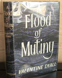
Dyall, Valentine
A Flood of Mutiny
London: Hutchinson. First edition. Hard cover in dust jacket. Published London: Hutchinson 1957 first printing. Small 8vo. 222 pp. Near fine in near fine dust jacket. . Near Fine. Hard. 1st. 1957. Hutchinson unknown
书商的参考编号 : 004466
|
|
|
Dyczek, Piotr
Rhizon. antyczna perla Czarnogóry anticki biser Crne Gore ancient pearl of Montenegro. [Von Piotr Dyczek].
Warsawa, Risan (Warschau): Center for Research on the Antiquity of Southeastern Europe 2014. 143, (1) Seiten. Mit zahlreichen farbigen Abbildungen. 4° (27 x 23 cm). Farbig illustrierter Orig.-Pappband. [Hardcover / fest gebunden].
书商的参考编号 : 2122975

|
|
|
Dyer GP. editor G. P.
ROYAL SOVEREIGN 1489-1989
Royal Mint Publication 1989. 99pp. Blue square hardback with DJ VG b&w and color photos Includes: A fifteenth century revival The early story The modern sovereign Sovereigns of the overseas branches A model of accuracy . Hard Cover. Very Good/Very Good. Royal Mint Publication Hardcover
书商的参考编号 : w170122727 ???????? : 1869917030 9781869917036
|
|
|
Dyfri Willams
Grecheskoe Zoloto. Yuvelirnoe Iskusstvo Klassicheskoy Epohi V-Iv Vv. Do N.E./ Greek Gold.
St. Petrsburg: Slaviya / British Museum Press 1995. 1st Edition 1st Printing. Soft cover. Fine. 271 Pp. Very Large Format Soft Cover Finely Printed Color Illustrations And Russian Text Throughout. Fine. With The Special Bookmark For This Book. <br/> <br/> Slaviya / British Museum Press paperback
书商的参考编号 : 050606 ???????? : 5886540032 9785886540031
|
|
|
Dykyjová, Dagmar and J. Kvet (Eds.)
Pond littoral ecosystems. Structure and functioning: Methods and results of quantitative ecosystem research in the Czechoslovakian IBP Wetland Project. (= Ecological Studies - Volume 28).
Springer, Berlin 1978. XIV, 464 S. mit 183 Abbildungen, Groß 8°, Original-Pappband (Hardcover), sehr gutes und innen sauberes Exemplar, (very good copy),
书商的参考编号 : 32502

|
|
|
Dylik, J
Województwo ze stolica bez antenatów. Geografia historyczna województwa lódzkiego.
Lódz, 1971. M. 8 Ktn.-Beil., 1 Kte., 1 Tab. u. 81 Abb. teils auf Taf. 187 S. (Szlakami nauki 15).
书商的参考编号 : 238011
|
|
|
 ?????????
 ?????PDF???
 RSS feed


