|
PETERMANN, A. (HRSG.).
Mittheilugen aus Justus Perthe's Geographischer Anstalt über wichtige neue Erforschungen auf dem Gebiete der Geographie. 23. Bd.
Gotha, Julius Perthes, 1877. 4to. Later hcloth. Spine gilt. XII,476 pp. and 23, partly folded, lithographed maps and plans. Internally clean.
Bookseller reference : 46640

|
|
|
PETERMANN, A. (HRSG.).
Mittheilugen aus Justus Perthe's Geographischer Anstalt über wichtige neue Erforschungen auf dem Gebiete der Geographie. 1860 (= Bd. 6 der Reihe). (+) 3 Ergänzungshefte. (1. A. Vibe: Küsten und Meer Norwegens. 24 pp., 1 chromolithographed plate (with ...
Gotha, Julius Perthes, 1860. 4to. Contemp, hcalf. Gilt spine. A small stamp to titlepage. X,490 pp. and 19, partly folded, lithographed maps and plans. Internally clean. + Ergänzungshäfte.
Bookseller reference : 46641
|
|
|
PETERMANN, A. (HRSG.).
Mittheilugen aus Justus Perthe's Geographischer Anstalt über wichtige neue Erforschungen auf dem Gebiete der Geographie. 1861 (= Bd. 7 der Reihe). (+) 3 Ergänzungshefte. (1. G. Lejean: Ethnographie de la Turque D'Europe. Ethnographie der Europäisch...
Gotha, Julius Perthes, 1861. 4to. Contemp, hcalf. Gilt spine. A small stamp to titlepage. VIII,482 pp. and 16, partly folded, lithographed maps and plans. Internally clean. + Ergänzungshäfte.
Bookseller reference : 46642
|
|
|
PETROV (Dimitri).
No Admittance to the Blind Man.
New York Hugo Gallery, s.d. [1945] 1 vol. broché Feuillet plié en trois (format A4) imprimé en noir annonçant une exposition de peintures et travaux automatiques. Formé à l'académie des Beaux-Arts de Pennsylvanie puis à la gravure à l'Atelier 17 avec Stanley Hayter, Dimitri Petrov (1919-1986), américain d'origine russe, était un artiste peintre Dada et surréaliste, membre du Woodstock Artists Association. Document provenant de la bibliothèque de Georges Bataille avec tampon à l'encre noire "Bibliothèque de Georges Bataille".
Bookseller reference : 103912
|
|
|
PETIT (Victor);
Palais de l'Exposition Universelle à Paris.
Paris Ch. Boivin 1855 235 x 411 mm.
Bookseller reference : LBW-671
|
|
|
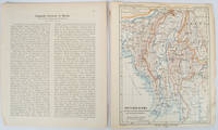
PETERMANN, AUGUST HEINRICH AND SCHMIDT, CARL (CARTOGRAPHER).
Burma map Britisch-Birma nach den neuesten Grenzbestimungen auf Grund amtlicher Quellen. from Petermann's Geographische Mitteilungen
Gotha: Justus Perthes. 1903. Map printed in colour 24.7 x19.4cm and leaf of descriptive text in German 26.5 x 22.5cm slight toning and edges of the map worn with two small tears no loss. Geopolitical map of Burma with railways and railways under construction highlighted. The accompanying text is by the German Tibetologist linguist and orientalist Dr Emil Schlagintweit. . Justus Perthes unknown
Bookseller reference : 173709
|
|
|
PETERMANN, A. (HRSG.).
Mittheilugen aus Justus Perthe's Geographischer Anstalt über wichtige neue Erforschungen auf dem Gebiete der Geographie. 1860 (= Bd. 6 der Reihe). (+) 3 Ergänzungshefte. (1. A. Vibe: Küsten und Meer Norwegens. 24 pp., 1 chromolithographed plate (with ...
Gotha, Julius Perthes, 1860. 4to. Contemp, hcalf. Gilt spine. A small stamp to titlepage. X,490 pp. and 19, partly folded, lithographed maps and plans. Internally clean. + Ergänzungshäfte.
|
|
|
PETERMANN, A. (HRSG.).
Mittheilugen aus Justus Perthe's Geographischer Anstalt über wichtige neue Erforschungen auf dem Gebiete der Geographie. 1861 (= Bd. 7 der Reihe). (+) 3 Ergänzungshefte. (1. G. Lejean: Ethnographie de la Turque D'Europe. Ethnographie der Europäisch...
Gotha, Julius Perthes, 1861. 4to. Contemp, hcalf. Gilt spine. A small stamp to titlepage. VIII,482 pp. and 16, partly folded, lithographed maps and plans. Internally clean. + Ergänzungshäfte.
|
|
|
PETERMANN, A. (HRSG.).
Mittheilugen aus Justus Perthe's Geographischer Anstalt über wichtige neue Erforschungen auf dem Gebiete der Geographie. 1858 (= Bd. 4 der Reihe).
Gotha, Julius Perthes, 1858. 4to. Contemp, hcalf. Gilt spine. A small stamp to titlepage. VIII,596 pp. and 20, partly folded, lithographed maps and plans. Text as well as maps fine and clean.
|
|
|
PETERMANN, A. (HRSG.).
Mittheilugen aus Justus Perthe's Geographischer Anstalt über wichtige neue Erforschungen auf dem Gebiete der Geographie. 1867 (= Bd. 13 der Reihe).
Gotha, Julius Perthes, 1867. 4to. Contemp, hcalf. Gilt spine. Spine somewhat rubbed. A small stamp to titlepage. VI,470 pp. and 19, partly folded, lithographed maps and plans. Textleaves with some browning and scattered brownspots. Maps clean.
|
|
|
PETERMANN, A. (HRSG.).
Mittheilugen aus Justus Perthe's Geographischer Anstalt über wichtige neue Erforschungen auf dem Gebiete der Geographie. 23. Bd.
Gotha, Julius Perthes, 1877. 4to. Later hcloth. Spine gilt. XII,476 pp. and 23, partly folded, lithographed maps and plans. Internally clean.
|
|
|
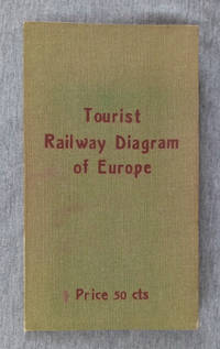
Peters, Al.
Tourist Railway Diagram of Europe Showing the Fares-Times-Distances Between Principal Cities Usually Visited By Americans
Berlin: Hobbing & Co. 1910. Hardcover. Good/no jacket. Green cloth over flexible card with red title 7.5 in tall folded map of Europe affixed to inside of rear cover. No date of publication given the map configuration showing Bohemia as part of Austria indicates a pre-World War I date. The map 22x23 in. shows the railway fares times and distances between cities. Also transatlantic steamer ports are underlined in red giving the name of steamship lines calling there. More detailed fare information for each country on reverse side. A clean map with 3 short tears at fold lines. Covers with brown tone at edges. Hobbing & Co. hardcover
Bookseller reference : 002299
|
|
|
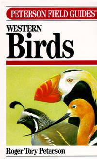
Peterson, Roger Tory - Text And Illustrations. Maps By Peterson, Virginia Marie
A Field Guide To Western Birds - Peterson Field Guide Third Edition Completely Revised and Enlarged
Boston: Houghton Mifflin Company. Vg In Wraps. Lightly Worn. A Completely New Guide To Field Marks Of All Speices Found In North America West Of The 100th Meridian & North Of Mexico. Pages: 432. 1990. Trade Paperback. Houghton Mifflin Company paperback
Bookseller reference : MASTER259778I ISBN : 039551424X 9780395514245
|
|
|
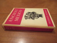
Peterson, Frederick, Jos Luis Franco (Maps and Illustrations)
Ancient Mexico: An Introduction to the Pre-Hispanic Cultures
New York NY: G.P. Putnam's Sons 1959. 1st U.S.A. Hardcover. Very Good/Good. 313 pages. Hardcover. B/w illustrations throughout. Cover boards bound in red cloth gilt title on spine. Dust jacket unclipped has some tanning covered in protective plastic no rips. Some tanning from age to pages and edges doesn't affect text or illustrations. In very good shape for its age. Books presents a coherent picture of ancient Mexico from the days of the early elephant hunters to the Spanish Conquest and deals with all the major groups: Aztecs Maya Totonacs Olmecs Toltecs Tarascans Mixtecs and Zapotecs. Record # 32162 G.P. Putnam's Sons hardcover
Bookseller reference : 32162

|
|
|
Peterson, Frederick; Maps And Drawings By Jose Luis Franco
Ancient Mexico: An Introduction to the Pre-Hispanic Cultures
New York: G. P. Putnam's Sons 1959. First Edition . Red Cloth. Near Fine/Near Fine DJ. Plates and Drawings. 313 Pp. Red Cloth Spine Gilt. First American Edition. Near Fine In Near Fine Dust Jacket: A Bright Clean Example No Names Or Marks Just A Trace Of Wear. Dj Complete Not Price-Clipped A Few Short Tears At Corners Aging At Spine And Edges But With Almost No Wear. <br/> <br/> G. P. Putnam's Sons hardcover
Bookseller reference : 019977
|
|
|
PETIT ATLAS NATIONAL
Carte d?partementale (noir) : Haute Sa?ne. Milieu XIXe.
Gravure 18x24 cm. Rousseurs.
|
|
|
PETIT ATLAS NATIONAL
Carte d?partementale (noir) : Loir et Cher. Milieu XIXe.
Gravure 18x24 cm. Rousseurs.
|
|
|
PETIT ATLAS NATIONAL
Carte d?partementale (noir) : Loiret. Milieu XIXe.
Gravure 18x24 cm. Rousseurs.
|
|
|
PETIT ATLAS NATIONAL
Carte d?partementale (noir) : Ni?vre. Milieu XIXe.
Gravure 18x24 cm. Rousseurs.
|
|
|
PETIT ATLAS NATIONAL
Carte d?partementale (noir) : Sa?ne et Loire. Milieu XIXe.
Gravure 18x24 cm. Rousseurs.
|
|
|
PETIT ATLAS NATIONAL
Carte d?partementale (noir). Bouches du Rh?ne. Fin XIXe.
Gravure 18x24 cm. Rousseurs.
|
|
|
PETIT ATLAS NATIONAL
Carte d?partementale (noir). Hautes Garonne. Milieu XIXe.
Gravure 18x24 cm. Rousseurs.
|
|
|
PETIT ATLAS NATIONAL
Carte d?partementale (noir). Var. Fin XIXe.
Gravure 18x24 cm. Rousseurs.
|
|
|
PETIT ATLAS NATIONAL
Carte d?partementale (noir). Vaucluse. Fin XIXe.
Gravure 18x24 cm. Rousseurs.
|
|
|
PETIT ATLAS NATIONAL
Carte du d?partement de la Somme. Milieu XIX?.
1 feuille 24x18 cm. Rousseurs.
|
|
|
PETIT Claude
LE BRIDGE CONTRAT. Les annonces.
Editions du Dauphin 1947, In-12 broché de 108 pages.
|
|
|
Peyre Bernard
Bully 1910-1916 - Correspondance d'Etienne Chabry 1910-1911 Etienne Chabry à Lyon / 1911-1912 Etienne Chabry à Montmélian / 912-1913 Etienne Chabry en Tunisie et au Maroc / 1914-1916 Étienne Chabry à La Guerre.
La Renardière, 2009 - Quatre volumes in Octavo 230 X 225mm complets sous coffret triangulaire laissant à voir les volumes, 183-97-317 et 155 pages, 720 photographies et document commentés dans le texte - en grande part cartes postales - Très bel ensemble pour cette somme monumentale assortie de mentions typographiées dans un cadre gris donnant à cet ensemble un aspect visuel dynamique.
Bookseller reference : 12871

|
|
|
PEYOT M.F.
Cours complet de fabrique pour les étoffes de soie. (Texte et Atlas reliés ensemble).
Lyon, Imprimerie Louis Perrin, 1866, 1 volume in-folio de 295x445 mm environ réunissant texte et atlas, (4) ff. (Titres, dédicaces, préface), 240 pages suivies de (2) ff. (Titres), 52 planches en noir et blanc. Pleine toile noire portant titres dorés sur pièce de cuir rouge, gardes couleurs. Reliure solide bien que frottée et tachée, quelques rousseurs marginales, rares annotations au crayon sinon intérieur en bon état.
Bookseller reference : 115123

|
|
|
PEYRALBE E. Nombreuses gravures, graphiques et cartes.
Le monde moins l'Europe. Première année. Enseignement primaire supérieur.
Couverture rigide. Cartonnage de l'éditeur. 360 pages. Légèrement défraîchi.
Bookseller reference : 144982
|
|
|
Peylet Benjamin
Le grand livre escape game Lupin - Saison 2: Résolvez de nouvelles énigmes sur les traces d'Assane
MARABOUT 2026 224 pages 17 8x24 6x2 7cm. 2026. Broché. 224 pages.
Bookseller reference : 500115677

|
|
|
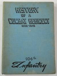
Pfc Henry Parrott, Lt Max Gissen. Maps By Pfc Arthur Hunker
History of a Combat Regiment 1639-1945 - 104th Infantry
N.P.: 104th Infantry United States Army 1945. First edition undated late 1945 signed by Commanding Officer Ralph W. Palladino on the introductory page. History of this venerable US Army Regiment from its roots as a militia unit in the American Revolution up through the end of World War II the period on which this book focuses. Includes maps other black and white illustrations from photographs list those killed or missing in action battle statistics etc. Light blue cloth printed in black Route of Advance map on endpapers book about 7.5 inches tall 153 pages no dustjacket likely issued without. Some soil to covers good hinges sound text block age-browning to the war-era paper used for the pages no other names or markings. Signed by the Commanding Officer. First Edition. Hard Cover. Good. 16mo - over 5¾" - 6¾" tall. 104th Infantry, United States Army Hardcover
Bookseller reference : 043919
|
|
|
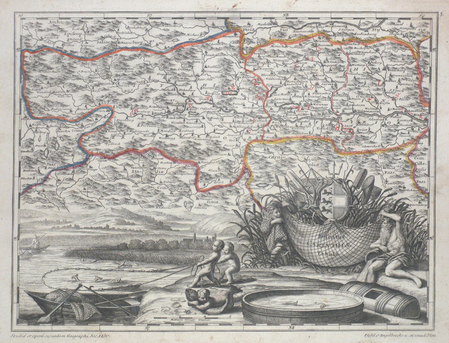
PFEFFEL (Johannes Andreas);
[CARINTHIE] Ducatus Carinthiae tabula.
Augsbourg circa 1740 252 x 333 mm.
Bookseller reference : LBW00359
|
|
|
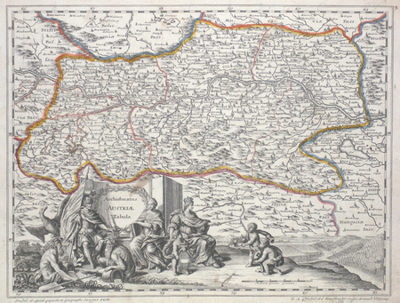
PFEFFEL (Johannes Andreas);
Archiducatus Austriae tabula.
Augsbourg circa 1740 252 x 333 mm.
Bookseller reference : LBW027af
|
|
|
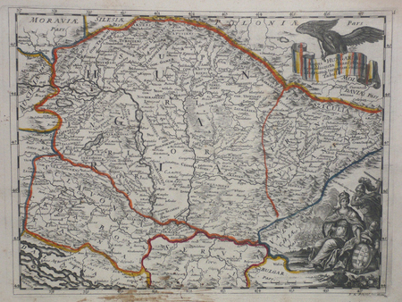
PFEFFEL (Johannes Andreas);
Regni Hungariae cum adiuncta Transylvania.
Augsbourg circa 1740 249 x 331 mm.
Bookseller reference : LBW027a2
|
|
|
PFEIFFER, Gustavo.
Mapa de España y Portugal. Panorama de la Península Ibérica. Topografía de M. Herrero. Grabado y publicado por...
Madrid, 1872. 4to., 22 cms; 89 x 65 cms., desplegado. Grabado en color, plegado. Montado sobre tela.. Escala 1:2.000.000. Encuadernación original en tela estampada.

|
|
|
Phelps, Gilbert
Latin America
109 pages, illustrated, maps, appendices, suggestions for further reading. eng
|
|
|
Phelps, Gilbert
Latin America
109 pages, illustrated, maps, appendices, suggestions for further reading. eng
|
|
|
Phenix, Penny; Murphy, Paul
Devon and Exmoor
No marks or inscriptions. No creasing to covers or to spine. A lovely clean very tight copy with bright unmarked boards and no bumping to corners. 128pp.

|
|
|
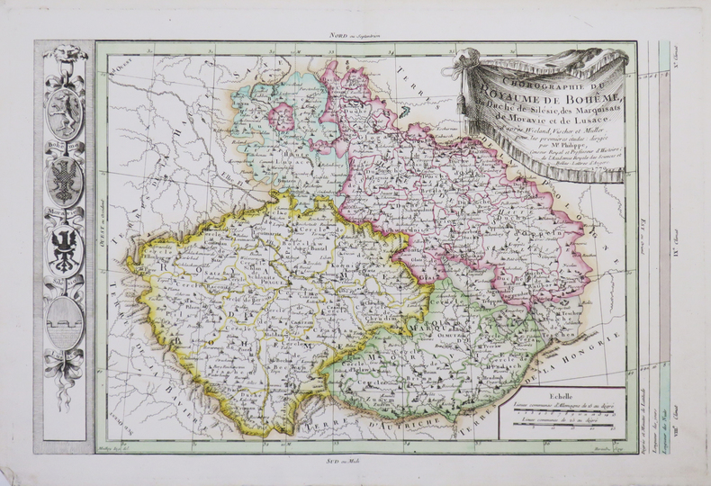
PHILIPPE de PRETOT (Etienne-André).
[BOHÊME] Chorographie du royaume de Bohême, du duché de Silésie, des marquisats de Moravie et de Lusace.
1770. 266 x 400 mm.
Bookseller reference : LBW-4662
|
|
|
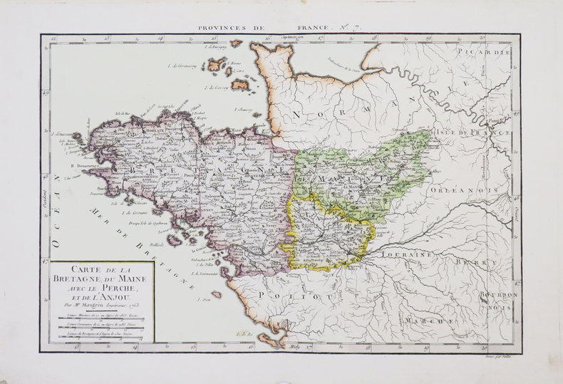
PHILIPPE de PRETOT (Etienne-André).
[BRETAGNE] Carte de la Bretagne, du Maine, avec le Perche, et de l'Anjou.
1763. 255 x 378 mm.
Bookseller reference : LBW-4660
|
|
|
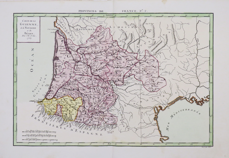
PHILIPPE de PRETOT (Etienne-André).
[GUYENNE/PAYS BASQUE] Carte de la Guienne, de la Navarre et du Béarn.
1763. 258 x 380 mm.
Bookseller reference : LBW-4656
|
|
|
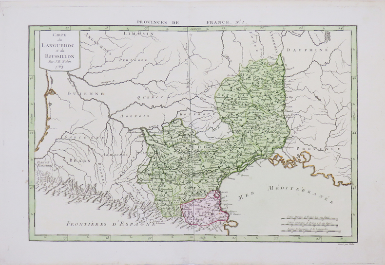
PHILIPPE de PRETOT (Etienne-André).
[LANGUEDOC-ROUSSILLON] Carte du Languedoc et du Roussillon.
1763. 253 x 378 mm.
Bookseller reference : LBW-4655
|
|
|
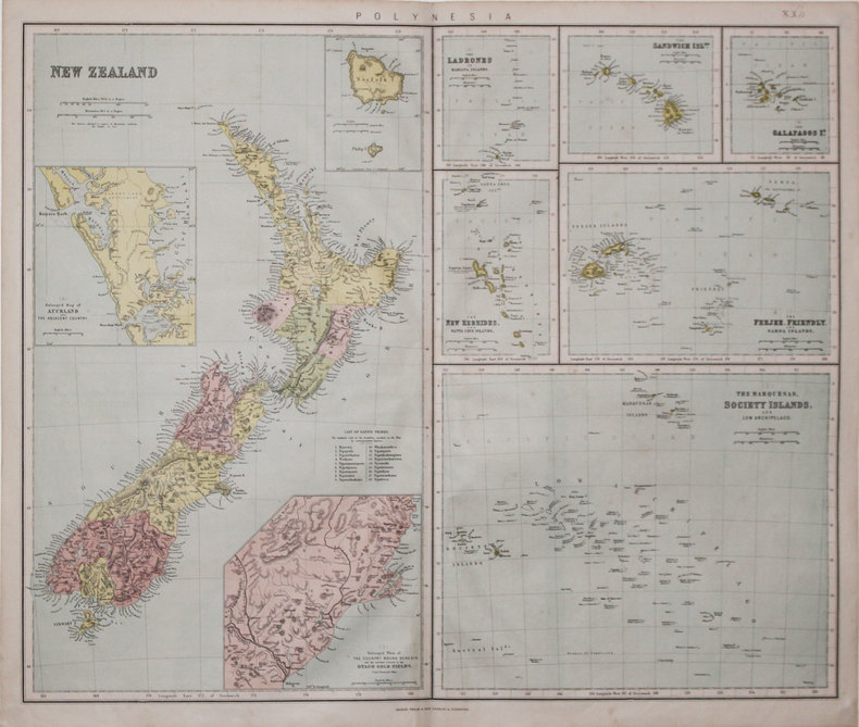
PHILIP & SON.
[NOUVELLE-ZÉLANDE] Polynesia.
London & Liverpool, Philip & Son, [circa 1865]. 520 x 610 mm.
Bookseller reference : LBW-3197
|
|
|
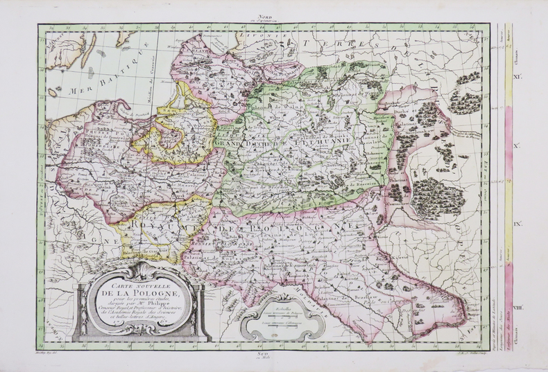
PHILIPPE de PRETOT (Etienne-André).
[POLOGNE] Carte nouvelle de la Pologne.
1767. 281 x 399 mm.
Bookseller reference : LBW-4663
|
|
|
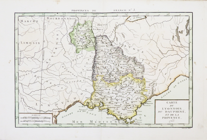
PHILIPPE de PRETOT (Etienne-André).
[PROVENCE] Carte du Lyonnois, du Dauphiné, et de la Provence.
1763. 250 x 375 mm.
Bookseller reference : LBW-4657
|
|
|
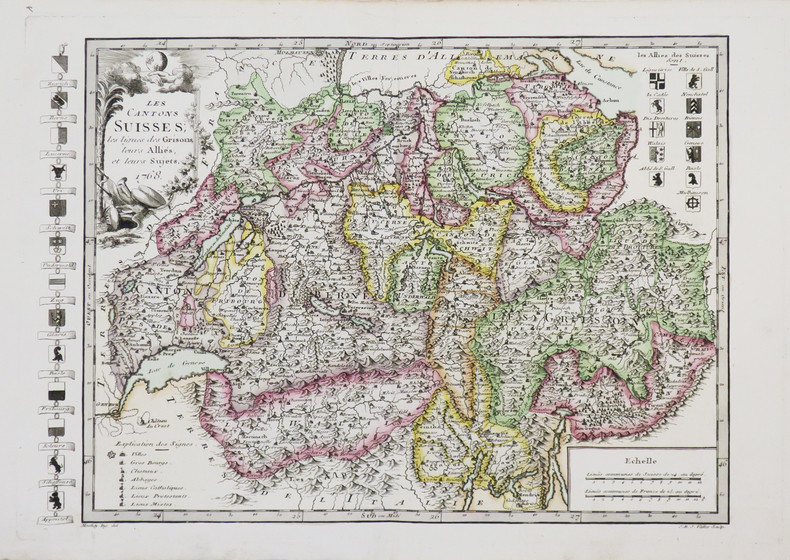
PHILIPPE de PRETOT (Etienne-André).
[SUISSE] Les Cantons suisses, les ligues des Grisons, leurs alliés, et leurs sujets.
1768. 264 x 372 mm.
Bookseller reference : LBW-4661
|
|
|
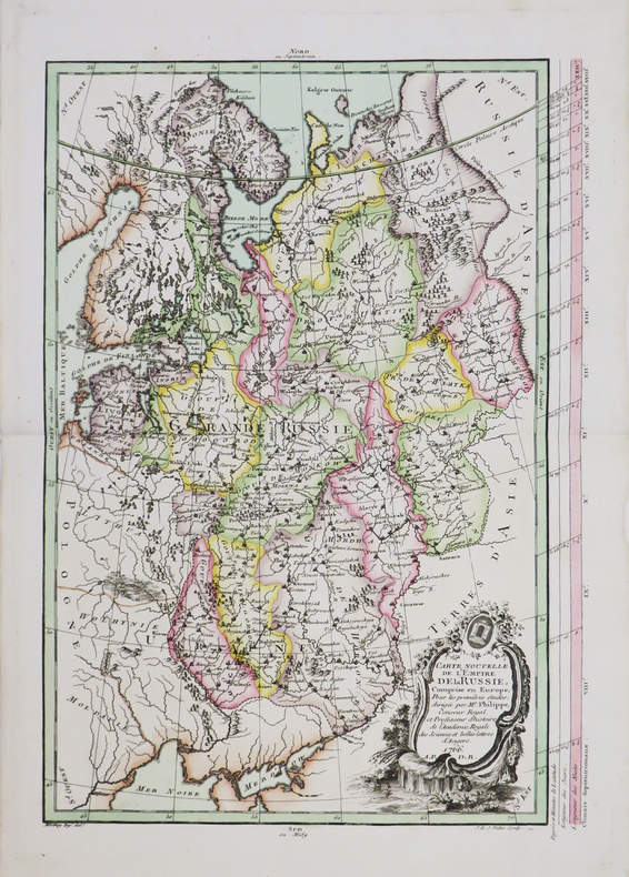
PHILIPPE de PRETOT (Etienne-André).
Carte nouvelle de l'empire de la Russie.
1766. 385 x 264 mm.
Bookseller reference : LBW-4654
|
|
|
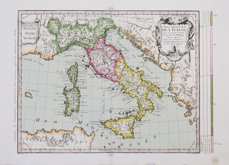
PHILIPPE de PRETOT (Etienne-André).
Carte générale de l'Italie.
1767. 275 x 375 mm.
Bookseller reference : LBW-4665
|
|
|
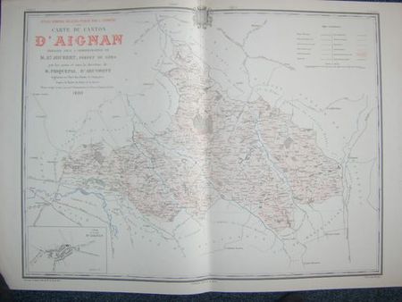
PHIQUEPAL D'ARUSMONT ; JOUBERT, M. E.
Carte du Canton d'Aignan (Atlas Général du Gers)
Carte du Canton dressée sous l'Administration de M. E. Joubert, préfet du Gers, par les soins et sous la direction de M. Phiquepal d'Arusmont, Ingénieur en chef des Ponts et Chaussées, revue, corrigée et mise à jour par l'Administration des Ponts et Chaussées, 1 carte en trois couleurs, 92 x 65 cm, gravée par A. Simon, Paris, Imp. Becquet, L. Chanche, Auch, 1880, échelle 1/40 000, avec le plan de la ville d'Aignan en cartouche (échelle 1 / 5000)
Bookseller reference : 15611
|
|
 Receive by email
 Download as PDF document
 RSS feed


