|
Author Not Stated
Visitor's Guide: Victoria, Vancouver Island, Vancouver - Sightseeing Maps
64 pages. Undated but appears to be early 1960s. Many colour photos and other illustrations. Provides a comprehensive snapshot of the many tourist attractions and services of these areas several decades ago. Unmarked with average wear. A great piece for those interested in the history of the tourism industry in these regions. Book

|
|
|
Automobile Association/Macmillan
Corfu and the Ionian Islands Traveller's Map Including a Plan of Corfu Town
London: Macmillan Map. As New. Folded Map. Large fold-out map Scale 1"1000. Macmillan paperback
Bookseller reference : 041546 ISBN : 0749500646 9780749500641
|
|
|
Automobile Association/Macmillan
Malta and Gozo Traveller's Map Including plans of Valletta Sliema and St.Paul's Bay
Basingstoke: Automobile Association / Macmillan Publishers 2004 Map. As New. Marbled Boards. A large-scale map designed to help visitors to plan their holidays and explore Malta and Gozo. It contains town plans hotels and details of local amenities and places of interest. Information in English Deutsch Italiano Francais Undated c.2004. Automobile Association / Macmillan Publishers hardcover
Bookseller reference : 040717 ISBN : 074950062X 9780749500627
|
|
|
Automobile Association
AA Road atlas of Great Britain
Elephant folio, 92 pages, colour maps. Covers creased. eng
|
|
|
Automobile Association
Bristol Street By Street
16mo, 172 pages, colour maps. eng
|
|
|
Automobile Association/Macmillan
Corfu and the Ionian Islands Traveller's Map, Including a Plan of Corfu Town
Large fold-out map Scale 1"1000 Map
|
|
|
Automobile Association/Macmillan
Malta and Gozo Traveller's Map, Including plans of Valletta, Sliema and St.Paul's Bay
A large-scale map designed to help visitors to plan their holidays and explore Malta and Gozo. It contains town plans, hotels and details of local amenities and places of interest. Information in English, Deutsch, Italiano, Franc?ais Undated c.2004? Map
|
|
|
AUTRIVE Valérie
"Votre avenir en 32 cartes; des révélations directes, des méthodes de voyance infaillibles, acquérir une maîtrise parfaite."
Paris, Editions Trajectoire, 2000. 16 x 24, 303 pp., très nombreuses figures, 2 tableaux, broché, très bon état.
Bookseller reference : 49174
|
|
|
AUTUN
Carte allemande.
1 feuille 80x66 cm. Tache en marge.
|
|
|
AUZIAS-TURENNE Raymond:
Voyage au pays des mines d'or. Le Klondike.
Paris, Calmann Lévy, 1899. Petit in-8 broché de [8]-318-[2] pages, couverture imprimée, décorée d'une reproduction… dorée de la plus grosse pépite trouvée dans l'Eldorado.
Bookseller reference : 15621
|
|
|
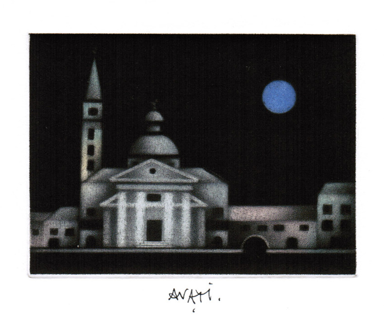
AVATI (Mario).
Carte de voeux illustrée d'une gravure originale signée.
Paris Galerie Sagot-Le Garrec 1980 1 vol. Broché Carte de voeux dépliante sur Arches illustrée d'une belle eau-forte en couleurs (13 x 17 cm) signée par Avati. En parfait état.
Bookseller reference : 109147
|
|
|
AVATI (Mario).
Carte de voeux illustrée d'une gravure originale signée.
Paris Galerie Sagot-Le Garrec 1980 1 vol. Broché Carte de voeux dépliante sur Arches illustrée d'une belle eau-forte en couleurs (13 x 17 cm) signée par Avati. En parfait état.
Bookseller reference : 109147
|
|
|
Avati, Mario
Carte de voeux pour 1992 : gravure à la manière noire
1992 Gravure en couleurs à la manière noire tirée en carte de voeux. 149 x 122 mm, sujet : 119 x 89 mm, signée à la plume, mention "Bon [sic] année 1992" à la plume au premier plat.
Bookseller reference : 1893
|
|
|
Avec Cartes Michelin
Le Guide Illustré De La France
France loisirs. Sans date. Bon état France loisirs unknown
Bookseller reference : 500128836
|
|
|
Avec Cartes Michelin
Le Guide Illustré De La France
France loisirs Sans date.
Bookseller reference : 500128836

|
|
|
AVELINE "il vecchio" Pierre (Pargi 1656 circa - 1722)
Profil de la Ville de Rome
Panorama di Roma preso dal Gianicolo, firmata "Aveline fecit et excudit", edita a Parigi presso Charpentier."La veduta panoramica di Roma è presa dal Gianicolo e raffigura sulla sinistra il complesso del Vaticano e Castel Sant'Angelo. AL centro il fitto tessuto urbano cittadino dal quale emergono torri e cupole non sempre riconoscibili. L'intera veduta è infatti condotta con grafia molto essenziale e immediata di non grande impatto visivo" (cfr. Barbara Jatta in "Roma Veduta" p. 193). La veduta viene attribuita dalla Jatta - soprattutto per motivi temporali legati all'editore Charpentier crediamo - ad Antoine Aveline "il giovane". La famiglia Aveline, appartenente alla borghesia parigina, lavorò per oltre due secoli nel campo artistico ed incisorio; visto il ripetersi dei nomi di battesimo e il fatto che apponevano la generica firma Aveline, si è spesso fatta confusione fra i sui vari componenti. Tuttavia l'imprint Aveline fecit et excudit lascia credere che l'edizione Charpentier sia il secondo stato (di tre) della lastra, che in seguito fu ristampata anche da Chereau. Quindi riteniamo più probabile - anche per lo stile grafico - attribuirla a Pierre Aveline e la data di stampa posta a circa il 1720 circa. Particolare curioso, la veduta non include il Colosseo. Nel margine inferiore, legenda di 47 numeri. Acquaforte, con ampli margini, consueta piega centrale, sporadiche e piccole ossidazioni nei margini bianchi nel complesso in ottimo stato di conservazione. Panorama of Rome taken from the Janiculum Hill, signed "Aveline fecit et excudit", published in Paris at Charpentier. The panoramic view of Rome is taken from the Janiculum Hill and depicts on the left the Vatican complex and Castel Sant'Angelo. At the center the dense urban fabric from which towers and domes emerge not always recognizable. The entire view is in fact conducted with very essential and immediate handwriting of not great visual impact (see Barbara Jatta in "Roma Veduta" p. 193). The view is attributed by Jatta to Antoine Aveline "the young". The Aveline family worked for over two centuries in the field of art and engraving; given the repetition of first names and the fact that they affixed the generic signature Aveline, there has often been confusion among the various members. However, the imprint Aveline fecit et excudit leads us to believe that the Charpentier edition is the second state (of three) of the plate, which was later reprinted also by Chereau. Therefore we think it more probable - also for the graphic style - to attribute it to Pierre Aveline and the date of printing placed at about 1720. Curious detail: the view does not include the Colosseum. In the lower margin, legend of 47 numbers. Etching, with wide margins, usual central fold, sporadic and small oxidations in the white margins, on the whole in very good condition. Arrigoni Bertarelli (1939): p. 20, n. 154; B. Jatta in "Roma Veduta", p. 193, n. 45; Marigiiani (2007), p. 262, n. 175.

|
|
|
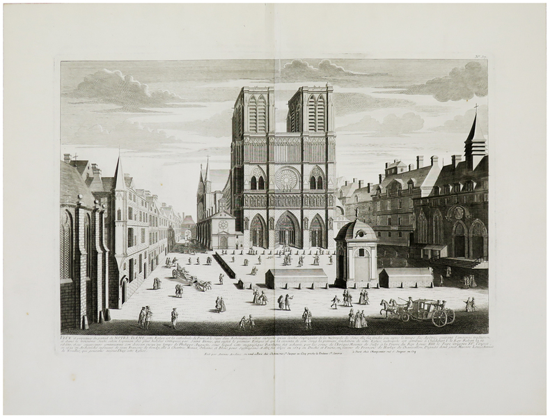
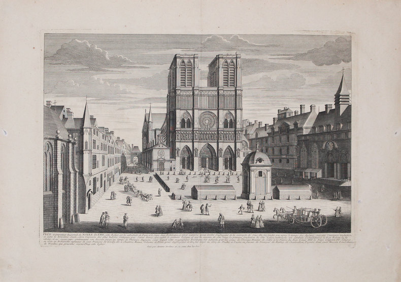
AVELINE (Antoine) & CHÉREAU (Jacques).
Veûe et perpectives du portail de Notre Dame.
Paris, Chéreau, [circa 1740]. 352 x 508 mm.
Bookseller reference : LBW-962
|
|
|
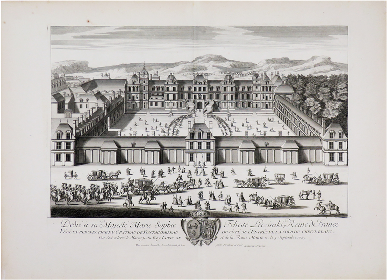
AVELINE (Antoine).
[FONTAINEBLEAU] Veuë et perspective du château de Fontainebleau du côté de l'entrée de la Cour du Cheval Blanc.
[circa 1740]. 380 x 510 mm.
Bookseller reference : LBW-6532
|
|
|
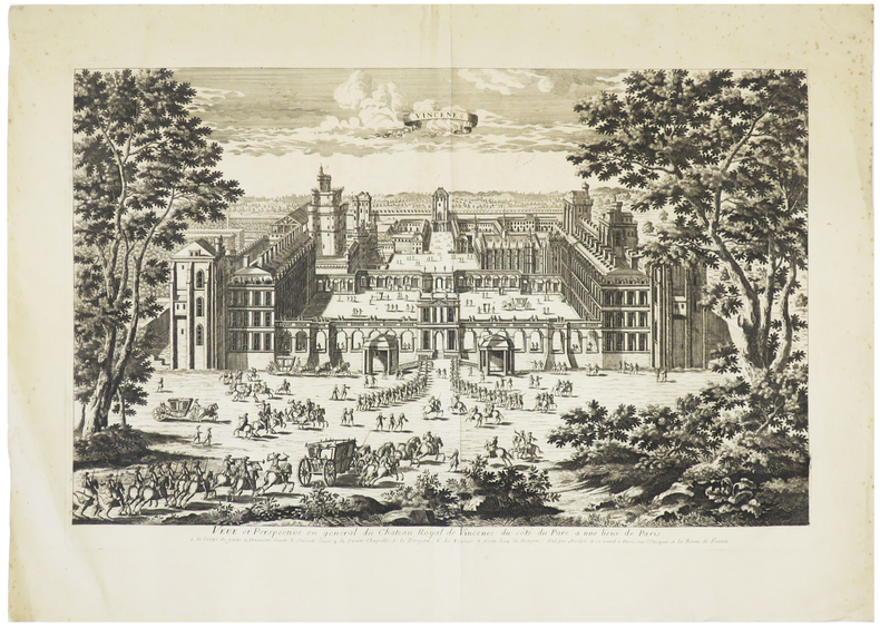
AVELINE (Antoine).
[VINCENNES] Veüe et perspective en général du château royal de Vincenes, du côté du parc à une lieüe de Paris.
Paris, [circa 1740]. 333 x 516 mm.
Bookseller reference : LBW-5738
|
|
|
AVELINE (Antoine).
Veûe et perspectives du portail de Notre Dame.
[circa 1740]. 352 x 511 mm.
Bookseller reference : LBW-3228
|
|
|
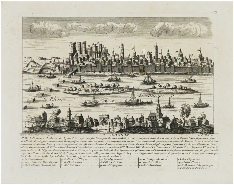
AVELINE (Pierre) & CRÉPY (Louis).
[AVIGNON] Avignon, ville de Provence, archevesché depuis l'an 1475.
Paris, Crépy, [circa 1720]. 176 x 204 mm.
Bookseller reference : LBW-6830
|
|
|
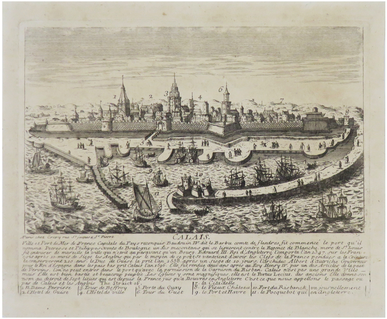
AVELINE (Pierre) & CRÉPY (Louis).
[CALAIS] Calais, ville et port de mer de France, capital du Pays reconquis.
Paris, Crépy, [circa 1720]. 176x 230 mm.
Bookseller reference : LBW-6818
|
|
|
AVELINE (Pierre) & CRÉPY (Louis).
[NANTES] Nantes, ville de France dans la haute Bretagne.
Paris, Crépy, [circa 1720]. 176x 220 mm.
Bookseller reference : LBW-6814
|
|
|
AVELINE (Pierre) & CRÉPY (Louis).
[VENISE] Venise, ville d'Italie et république souveraine du golfe qui porte son nom.
Paris, Crépy, [circa 1720]. 166x 212 mm.
Bookseller reference : LBW-6862

|
|
|
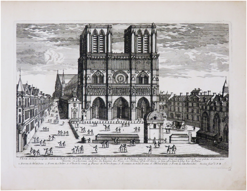
AVELINE (Pierre).
[NOTRE-DAME] Veue de la principale entrée de l'église de Nôtre Dame de Paris, bâtie sous le règne de Philippe Auguste environ l'an 1200.
[circa 1690]. 207 x 305 mm.
Bookseller reference : LBW-7969
|
|
|
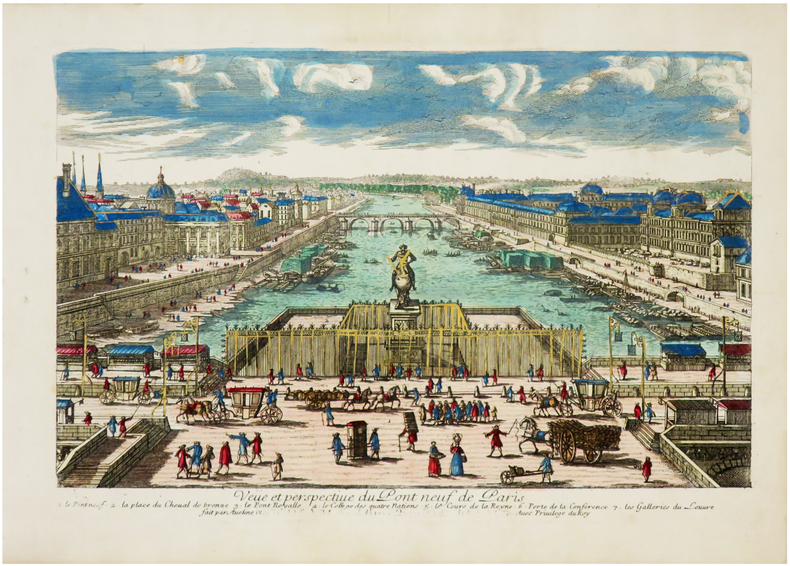
AVELINE (Pierre).
[PONT-NEUF] Veüe et perspective du Pont Neuf de Paris.
[circa 1690]. 166x 212 mm.
Bookseller reference : LBW-6971
|
|
|
AVELINE (Pierre).
Constantinople ville de Romanie et capitale de l'empire des Turcs.
[1692]. 206 x 317 mm.
Bookseller reference : LBW-706

|
|
|
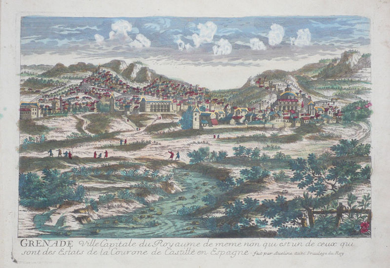
AVELINE (Pierre).
Grenade ville capitale du royaume de meme non qui est un de ceux qui sont des estats de la Courone de Castille en Espagne.
[circa 1690]. 215 x 313 mm.
Bookseller reference : LBW-946
|
|
|
AVELINE (Pierre).
Inspruck ville d’Allemagne capitale du comté de Tirol.
[circa 1695]. 209 x 307 mm.
Bookseller reference : LBW-793

|
|
|
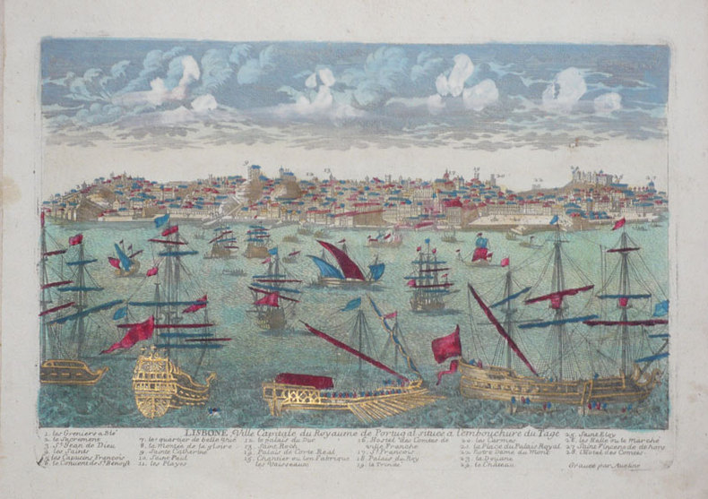
AVELINE (Pierre).
Lisbone, ville capitale du royaume de Portugal située à l'embouchure du Tage.
[circa 1690]. 210 x 305 mm.
Bookseller reference : LBW-945
|
|
|
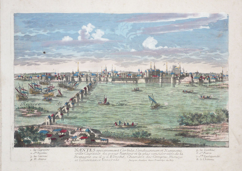
AVELINE (Pierre).
Nantes ancienement Corbilo, Condivineum et Namnetes, ville capitale du pays nantois et la plus considérable de la Bretagne ou il y a Eveché, Chambre des Comptes, Monoye et Lieutenance Générale.
[circa 1690]. 216 x 309 mm.
Bookseller reference : LBW-1286
|
|
|
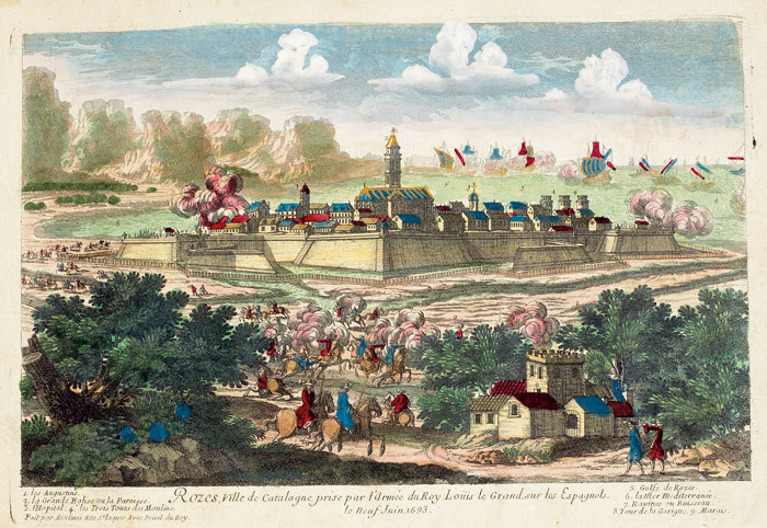
AVELINE (Pierre).
Rozes, ville de Catalogne prise par l’armée du roy Loüis le Grand, sur les Espagnols.
[circa 1695]. 207 x 303 mm.
Bookseller reference : LBW-790
|
|
|
AVELINE Claude
LE CODE DES JEUX
1961 broché petit (small paperback) in-octavo, dos (spine) blanc jaune, couverture ornée d'illustrations photographiques en couleurs sur le recto/verso (photographics illustrations in colours on the cover), tranches (edges) jaunes, illustrations : figures (pictures), 642 pages, 1961 à Paris Librairie Hachette,
Bookseller reference : 10439
|
|
|
AVEZAC M. d’; LA MALLE M. Dureau de; YANOSKI J.; LACROIX Louis:
L’univers. Histoire et description de tous les peuples. Afrique. Esquisse générale de l’Afrique et Afrique ancienne, par M. d’Avezac, Carthage, par M. Dureau de La Malle et par M. J. Yanoski, Numidie et Mauritanie, par M. Louis Lacroix, L’Afrique chrétienne et domination des Vandales en Afrique, par M. J. Yanoski.
Paris, Firmin Didot frères, 1844. 1 vol. in-8 de III-272,-[12]-170-96-63-108-[2] pages, cartonnage d’éditeur bleu, dos lisse orné, plats ornés. Coiffes, coins et mors frottés, quelques rousseurs.
Bookseller reference : 2219
|
|
|
Avi Yonah, Michael [Ed.]
Sepher Yerushalayim (The Book of Jerusalem): Jerusalem, its Natural Conditions, History and Development from the Origins to the Present Day- in Two Volumes [THIS VOLUME ONLY]
29x20 cm. 431 pages. Gilt hardcover. Contains black & white plates and folded maps. Cover is slightly worn. Spine of book is worn. Spine is visible between a few pages. Slight discoloring of the upper, external part of pages. Else in good condition. PLEASE NOTE: This item is overweight. We may ask for extra shipping costs.
|
|
|
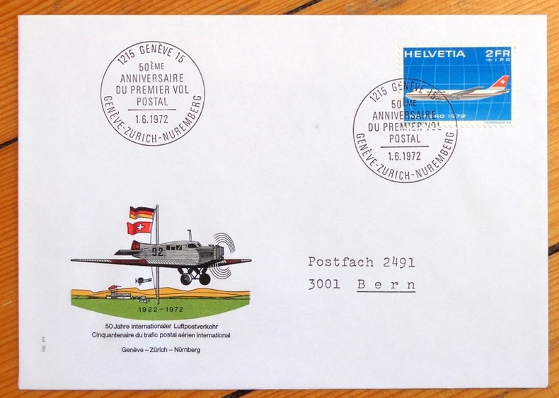
Aviation:
Cinquantenaire du trafic postal aérien. Genève-Zürich-Nürnberg. Enveloppe commémorative.
1972. Enveloppe au format 11,5 x 16, timbre et vignette couleurs, affranchissement philatélique, au 1er juin 1972 à Genève, à la même date à Nürnberg au dos.
Bookseller reference : 4858
|
|
|
Awesome Maps
Bucket List World Map
NEW. unknown
Bookseller reference : BIB-NOV-14-2025-116019 ISBN : 1888216670 9781888216677
|
|
|
AXELMAN
Incarnations
1994 Editions Fleuve Noir, Collection "Angoisses" dirigée par Juliette Raabe N° 9 - 1994 - In-12 broché, couverture illustrée - Illustration Marc Demoulin
Bookseller reference : 92336
|
|
|
Axelrod Robert
Structure of Decision: The Cognitive Maps of Political Elites (Princeton Legacy Library)
PRINCETON UNIV PR 1976 422 pages in8. 1976. Broché. 422 pages.
Bookseller reference : 100138800 ISBN : 691100500

|
|
|
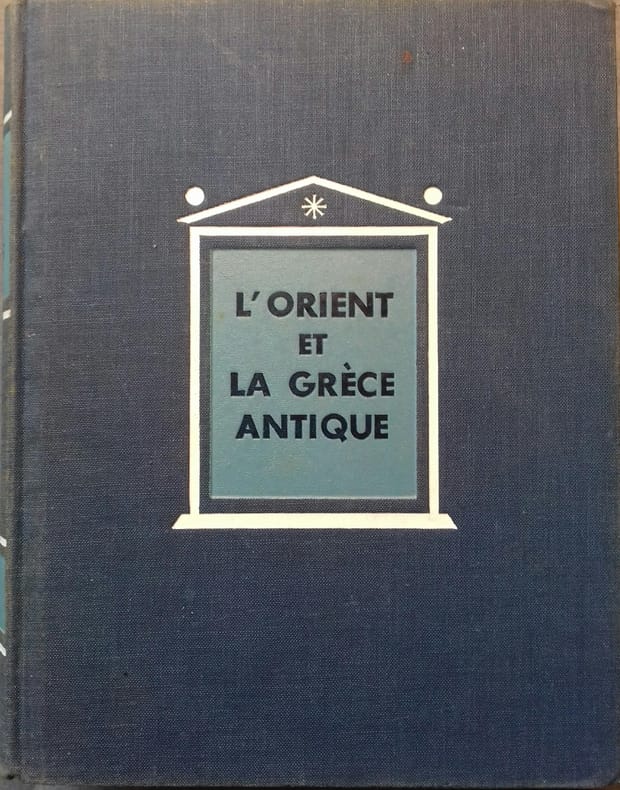
AYMARD André - AUBOYER Jeannine Illustrations en noir et blanc. Cartes, plans.
L'Orient et la Grèce antique.
Couverture rigide. Reliure de l'éditeur en toile bleue. 18 x23 cm. 701 pages.
Bookseller reference : 133134
|
|
|
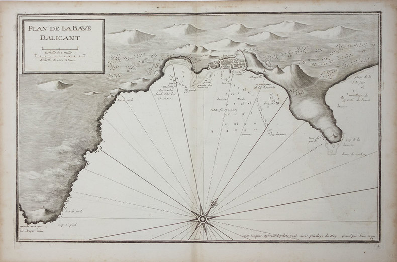
AYROUARD (Jacques).
[ALICANTE] Plan de la baye d'Alicant.
[circa 1730]. 291 x 454 mm.
Bookseller reference : LBW024fc
|
|
|
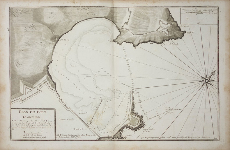
AYROUARD (Jacques).
[ANTIBES] Plan du port d'Antibe.
[circa 1730]. 297 x 452 mm.
Bookseller reference : LBW-3328
|
|
|
AYROUARD (Jacques).
[ANZIO] Plan du port d'Ancio.
[circa 1730]. 298 x 456 mm.
Bookseller reference : LBW0029d

|
|
|
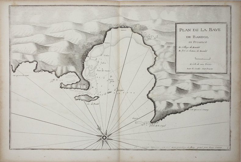
AYROUARD (Jacques).
[BANDOL] Plan de la baye de Bandol en Provence.
[circa 1730]. 297 x 455 mm.
Bookseller reference : LBW004e7
|
|
|
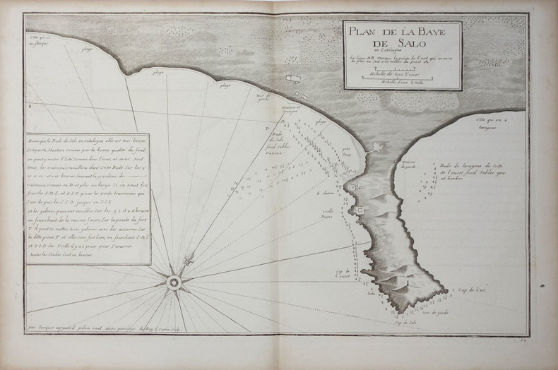
AYROUARD (Jacques).
[CATALOGNE/SALOU] Plan de la baye de Salo en Catalogne.
[circa 1730]. 290 x 447 mm.
Bookseller reference : LBW024ee
|
|
|
AYROUARD (Jacques).
[CATALOGNE/SANT FELIU] Plan de la baye de St. Philiou en Catalogne.
[circa 1730]. 285 x 442 mm.
Bookseller reference : LBW024ef

|
|
|
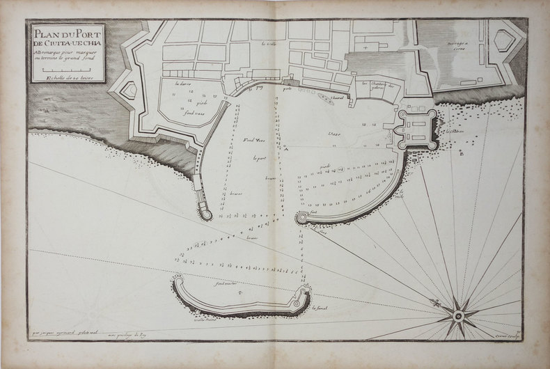
AYROUARD (Jacques).
[CIVITAVECCHIA] Plan du port de Civita-Vechia.
[circa 1730]. 290 x 456 mm.
Bookseller reference : LBW0027e
|
|
|
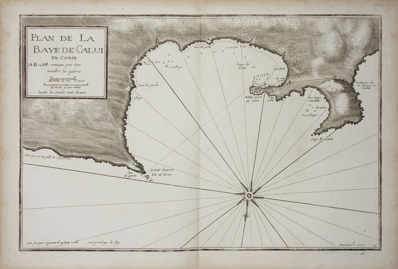
AYROUARD (Jacques).
[CORSE/CALVI] Plan de la baye de Calvi en Corse.
[circa 1730]. 287 x 450 mm.
Bookseller reference : LBW002c0
|
|
|
AYROUARD (Jacques).
[CORSE/SAINT-FLORENT] Plan du golfe de St. Fiorenzo en lisle de Corse.
[circa 1730]. 298 x 456 mm.
Bookseller reference : LBW-3329

|
|
|
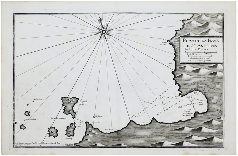
AYROUARD (Jacques).
[IBIZA] Plan de la baye de S.t Antoine en lisle d'Ivice.
[circa 1730]. 289 x 450 mm.
Bookseller reference : LBW-6149
|
|
 Receive by email
 Download as PDF document
 RSS feed


