|
ORDNANCE SURVEY
Ordnance Survey. St. Albans. (Large Sheet Series with Layers). Sheet 29. Scale: Two Miles to One Inch.
Folding coloured map on cloth measuring 20.5 x 28.5 ins (approx. 52.0 x 72.0 cms) folding in 24 panels to 7.0 x 3.75 ins (approx. 17.75 x 9.5 cms), some mild age-soiling; original white cloth wrappers blocked and lettered in black, wrappers mildly age-soiled and lightly frayed at extremities else a good, clean copy.

|
|
|
Ordnance Survey
Pwllheli : One-Inch Map of Great Britain No 115 (cloth)
Cloth backed map in near fine condition, unmarked and not rubbed with some creasing near the folds.. Dusty cover with nicks to the oversize extremeties. 1pp. Seventh Series.

|
|
|
Ordnance Survey
Reprint of the First Edition of the One-inch ORDNANCE SURVEY of England and Wales : Sheet No. 21 : Huddersfield & Manchester
Large fold-out map in excellent unmarked condition. 1pp.

|
|
|
Ordnance Survey
Reprint of the First Edition of the One-inch ORDNANCE SURVEY of England and Wales : Sheet No. 26 : Northwich & Warrington
Large fold-out map in excellent unmarked condition. Slip folder with very slight bumps to corners. 1pp. Reprint of the Ordnance Survey map covering parts of Cheshire and (originally) Lancashire with data up to about 1890.
|
|
|
Ordnance Survey
Reprint of the First Edition of the One-inch ORDNANCE SURVEY of England and Wales : Sheet No. 43 : Leicester
Large fold-out map in very good unmarked condition with some rubbing to fold corners. Slip folder unmarked with some rubbing and creasing . 1pp. Reprint of the Ordnance Survey map covering Leicester and surrounding area with data up to about 1890.

|
|
|
Ordnance Survey
Snowdon: Sheet 107
Very light wear to covers. eng
|
|
|
Ordnance Survey
Wenlock Edge (North): Sheet SO 59
no publication date (1970s), scale 1: 25000 eng
|
|
|
ORDNANCE SURVEY 1916
Carte De France Entoilée , ST OMER . Section Sheet 27° S.E., de La 1° Guerre Mondiale ( Map of France of Sheet 27° S.E. For the First War )
Carte entoilée illustrée . Plan de St Omer , Wisques , Quelmes , Acquin , forêt national de Tournehem , Norbécourt , Houlle , St Momelin au 1/20 000° en couleurs . L'entoilage ensanglanté par la blessure du soldat est imprimé d'un glossaire ( glossary ) français-anglais . Quelques défauts d'usages que l'on pardonnera vues les conditions dans lesquelles cette guerre de tranchées s'est déroulée . Histoire 1° Guerre Mondiale . - 1 p. , 250 gr.
|
|
|
Ordnance Survey of Great Britain
England, South East and London World War II Map: England & Wales Air Sheet 12
33"x23" reinforced paper map. Undated - circa 1945? Scale: one quarter inch to one mile Geographical Section, General Staff, No. 3957 (Air). "F/O Ellis" neatly printed in each corner in ink. Average wear. Book
|
|
|
Ordnance Survey of Ireland
Ordnance Survey of Ireland 1:250,000 Sheet 5 South West
No marks or inscriptions. Clean, not torn folded 1:250, 000 map opens out to 28 x 35 inches. Tiny nicks/creasing to oversized part of slightly sunned covers. 1pp. Covers South West Ireland from Limerick in the north down to Cork and Killarney in the west across to Tipperary.
|
|
|
Ordnance Survey.
MAP OF ROMAN BRITAIN (Third Edition). Scale Sixteen Miles to One Inch.
44 p. + Very Large Folding Color Map and text maps. 270mm. Original pictorial wraps. Softbound. Nice copy. Very good+ CLASSICS BX 2
|
|
|
Oriental Maps Nomura Yukichi
Higher Education Skills
Oriental Maps Nomura Yukichi 1943. Soft Cover. Fine. The book is in fine condition. Oriental Maps Nomura Yukichi paperback
Bookseller reference : 2083002116200857
|
|
|
Oriental Maps Tokuno Bunji Takashina Junji
Introduction to Higher Education Philosophy
Oriental Maps Tokuno Bunji Takashina Junji 1941. Soft Cover. Fine. The book is in fine condition. Oriental Maps Tokuno Bunji Takashina Junji paperback
Bookseller reference : 2083002116203428
|
|
|
Oriental Maps Tameji Hashimoto
Jinshi's science education
Oriental Maps Tameji Hashimoto 1932. Soft Cover. Fine. The book is in fine condition. Oriental Maps Tameji Hashimoto paperback
Bookseller reference : 2083002116200606
|
|
|
Oriental Maps Masatoshi Yoshii
Mineralogy and Geology for Higher Education 2 volumes
Oriental Maps Masatoshi Yoshii 1930. Soft Cover. Fine. Number of books: 2 Oriental Maps Masatoshi Yoshii paperback
Bookseller reference : 2083002116201908
|
|
|
Oriental Maps Sagenji Kobayashi
Multiple education
Oriental Maps Sagenji Kobayashi 1937. Soft Cover. Fine. The book is in fine condition. Oriental Maps Sagenji Kobayashi paperback
Bookseller reference : 2083002116201372
|
|
|
Oriental Maps Megumi Ito
new course ethics
Oriental Maps Megumi Ito 1935. Soft Cover. Fine. The book is in fine condition. Oriental Maps Megumi Ito paperback
Bookseller reference : 2083002116200065
|
|
|
Oriental Maps Hamura Suzuki
penmanship department
Oriental Maps Hamura Suzuki 1930. Soft Cover. Fine. The book is in fine condition. Oriental Maps Hamura Suzuki paperback
Bookseller reference : 2083002116200566
|
|
|
Oriental Maps Kaoru Miyamichi
Rikagakushi Monogatari New Revised Edition
Oriental Maps Kaoru Miyamichi 1939. Soft Cover. Fine. The book is in fine condition. Oriental Maps Kaoru Miyamichi paperback
Bookseller reference : 2083002116200578
|
|
|
Oriental Maps Yoshimitsu Nonaka. Kiyoshi Tsukamoto
School education ceremony. lesson
Oriental Maps Yoshimitsu Nonaka. Kiyoshi Tsukamoto 1934. Soft Cover. Fine. The book is in fine condition. Oriental Maps Yoshimitsu Nonaka. Kiyoshi Tsukamoto paperback
Bookseller reference : 2083002116201764
|
|
|
Oriental Maps Mitsuru Sato
Second grade new physics textbook
Oriental Maps Mitsuru Sato 1929. Soft Cover. Fine. The book is in fine condition. Oriental Maps Mitsuru Sato paperback
Bookseller reference : 2083002116200482
|
|
|
Oriental Maps Suzuki Harumi
Shinko Calligraphy History Corrected Edition
Oriental Maps Suzuki Harumi 1942. Soft Cover. Fine. The book is in fine condition. Oriental Maps Suzuki Harumi paperback
Bookseller reference : 2083002116201149
|
|
|
Orlandi, Stefano
S. Maria Novella e i suoi chiostri monumentali. Piccola guida storico-artistica.
cm. 13,5 x 22, 64 pp. con 51 ill. 131 gr. 64 p.
|
|
|
ORNANCE SURVEY
Ordnance Survey Map of South London and Environs. Third Edition. One Inch. [Stanford cover]. IN STANFORD COVER
Folding coloured map on cloth measuring 21.5 x 30.5 ins (approx. 54.5 x 77.5 cms) folding in 21 panels to 7.0 x 4.5 ins (approx. 17.75 x 11.5 cms), lightly age-soiled as usual ; original marbled wrappers, upper wrapper with printed paper label, two folds neatly reinforced with tape, wrappers mildly age-faded else a very good, clean copy. The survey for the Third Edition (the second revision of the New Series) was carried out between 1901 and 1912. Coverage extends to Reigate in the south. Scarce in the Stanford cover, immediately predating the first of the OS-branded covers published in 1914.
|
|
|
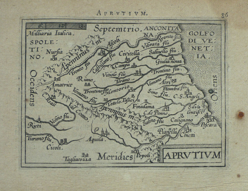
ORTELIUS (Abraham);
[ABRUZZES] Aprutium.
Anvers 1598 80 x 105 mm.
Bookseller reference : LBW-1406
|
|
|
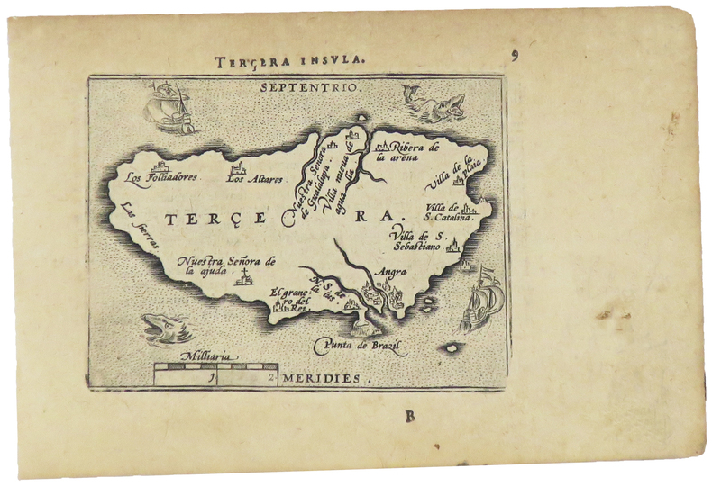
ORTELIUS (Abraham).
[ACORES] Terçera insula.
[Anvers, 1598]. 82 x 103 mm.
Bookseller reference : LBW-1400
|
|
|
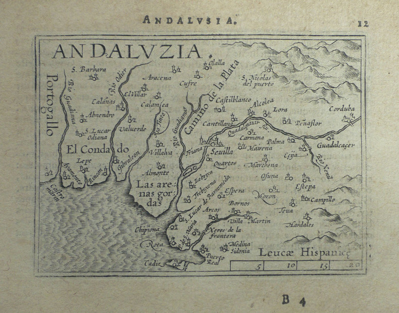
ORTELIUS (Abraham);
[ANDALOUSIE] Andaluzia.
Anvers 1598 80 x 102 mm.
Bookseller reference : LBW-1398
|
|
|
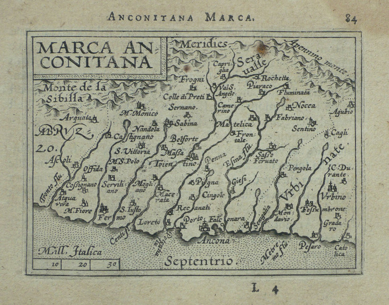
ORTELIUS (Abraham);
[ANCONE] Marca Anconitana.
Anvers 1598 82 x 106 mm.
Bookseller reference : LBW-1407
|
|
|
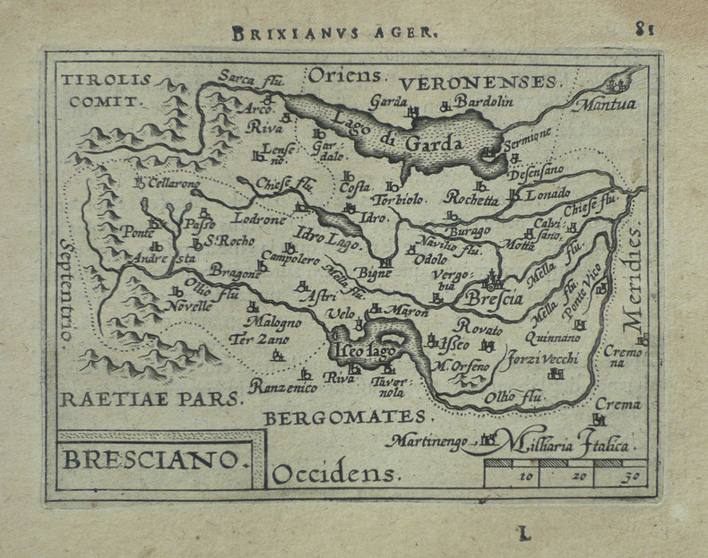
ORTELIUS (Abraham);
[BRESCIA] Bresciano.
Anvers 1598 82 x 106 mm.
Bookseller reference : LBW-1419
|
|
|
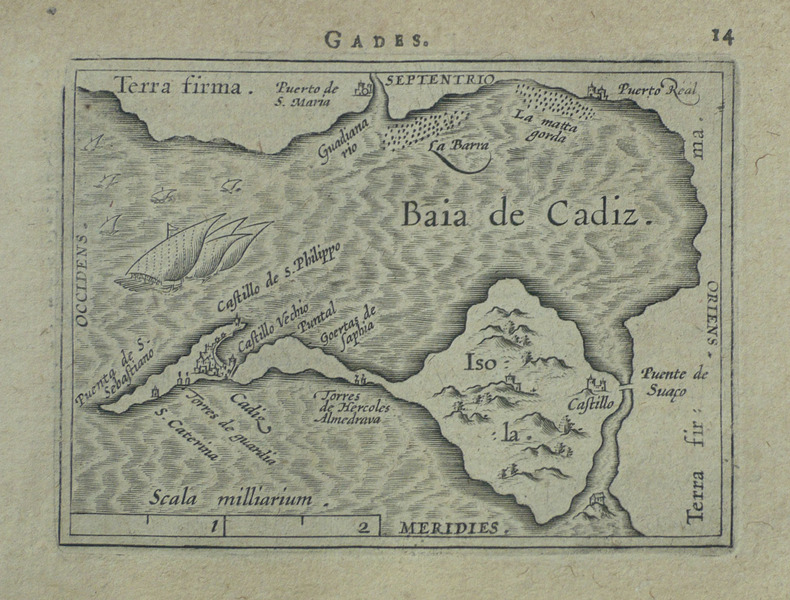
ORTELIUS (Abraham);
[CADIX] Gades.
Anvers 1598 81 x 104 mm.
Bookseller reference : LBW-1499
|
|
|
ORTELIUS (Abraham);
[CROATIE] Histria.
Anvers 1598 82 x 105 mm.
Bookseller reference : LBW-1389

|
|
|
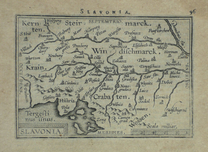
ORTELIUS (Abraham);
[CROATIE] Slavonia.
Anvers 1598 80 x 110 mm.
Bookseller reference : LBW-1399
|
|
|
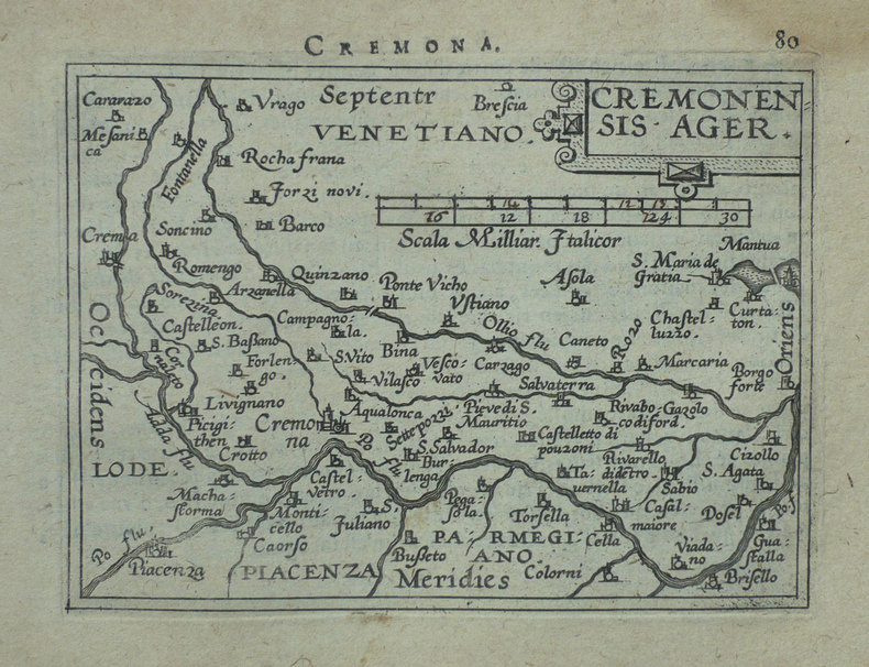
ORTELIUS (Abraham);
[CREMONE] Cremonensis ager.
Anvers 1598 80 x 105 mm.
Bookseller reference : LBW-1418
|
|
|
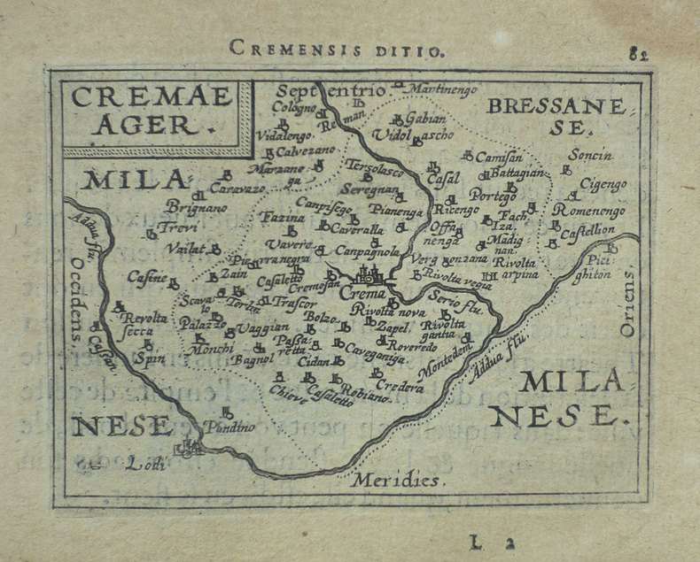
ORTELIUS (Abraham);
[CREMA] Cremae ager.
Anvers 1598 82 x 105 mm.
Bookseller reference : LBW-1421
|
|
|
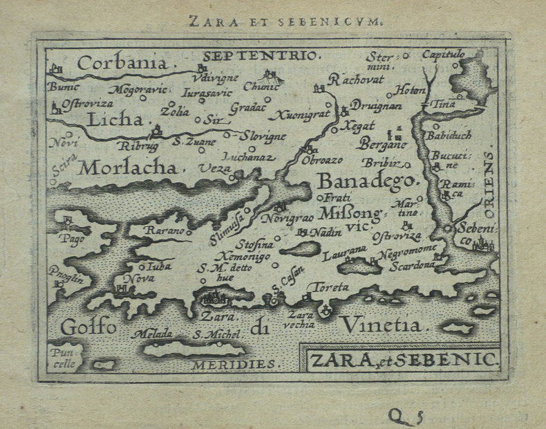
ORTELIUS (Abraham);
[CROATIE] Zara et Sebenico.
Anvers 1598 81 x 105 mm.
Bookseller reference : LBW-1430
|
|
|
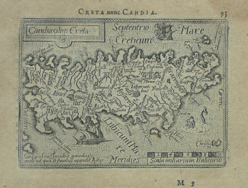
ORTELIUS (Abraham);
[CRETE] Candia olim Creta.
Anvers 1598 82 x 106 mm.
Bookseller reference : LBW-1432
|
|
|
ORTELIUS (Abraham);
[FLORENCE] Florentinum dominium.
Anvers 1598 81 x 105 mm.
Bookseller reference : LBW-1410

|
|
|
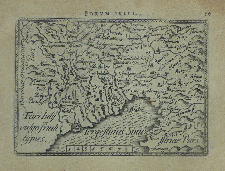
ORTELIUS (Abraham);
[FRIOUL] Fori Iuly vulgo Friuli typus.
Anvers 1598 82 x 105 mm.
Bookseller reference : LBW-1422
|
|
|
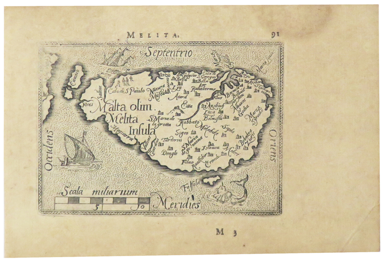
ORTELIUS (Abraham).
[MALTE] Melita.
[Anvers, 1598]. 80 x 107 mm.
Bookseller reference : LBW-5386
|
|
|
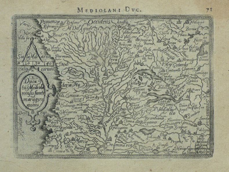
ORTELIUS (Abraham);
[MILANAIS] Ducatus Mediolanensis finitimarumq regionis.
Anvers 1598 83 x 110 mm.
Bookseller reference : LBW-1412
|
|
|
ORTELIUS (Abraham);
[ORVIETO] Oropitum.
Anvers 1598 81 x 105 mm.
Bookseller reference : LBW-1415

|
|
|
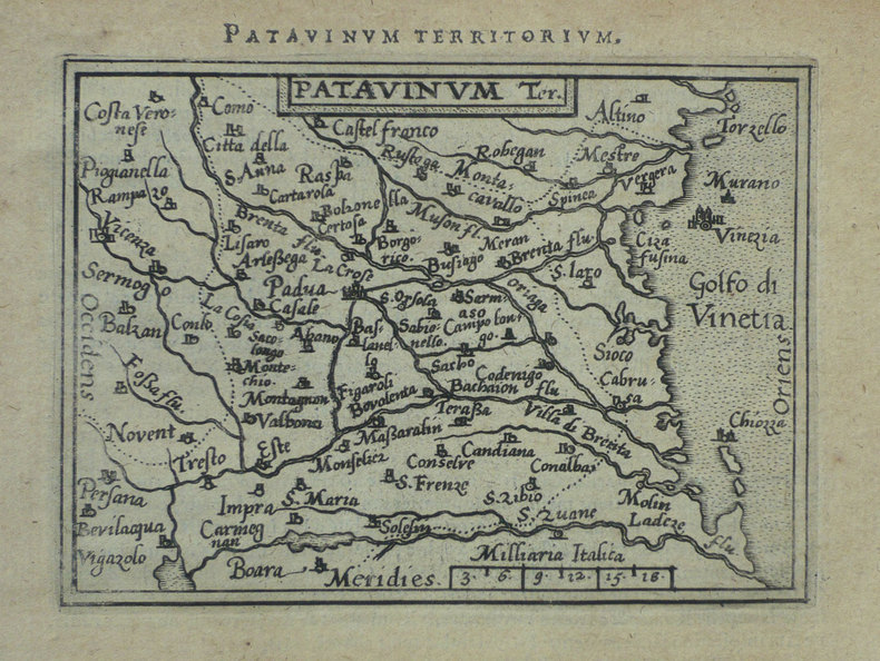
ORTELIUS (Abraham);
[PADOUE] Patavinum.
Anvers 1598 82 x 105 mm.
Bookseller reference : LBW-1423
|
|
|
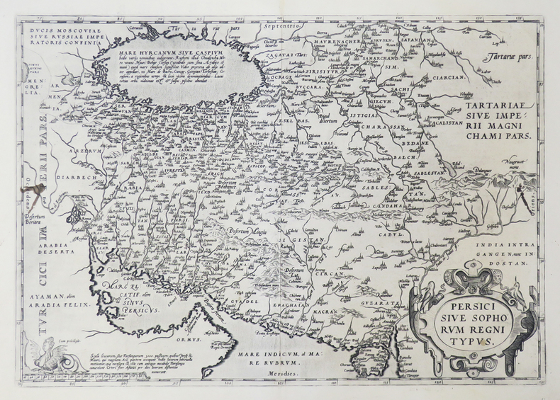
ORTELIUS (Abraham).
[PERSE] Persici sive Sophorum regni typus.
[Anvers, 1592]. 349 x 496 mm.
Bookseller reference : LBW0251e
|
|
|
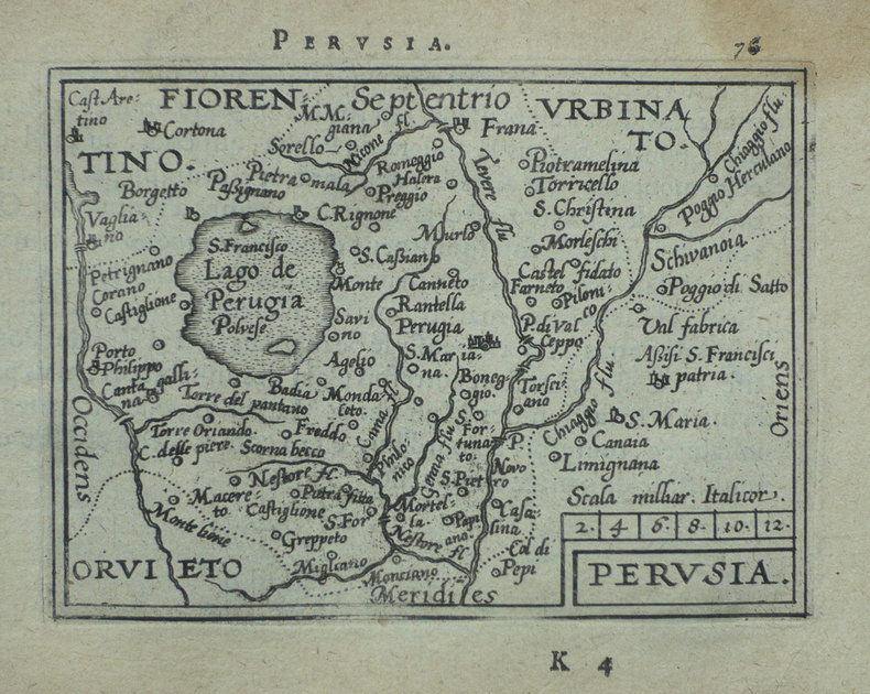
ORTELIUS (Abraham);
[PEROUSE] Perusia.
Anvers 1598 82 x 107 mm.
Bookseller reference : LBW-1416
|
|
|
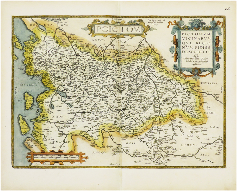
ORTELIUS (Abraham).
[POITOU] Poictou. Pictonum vicinarumque regionum fidiss descriptio.
Anvers, 1579 [1612]. 360 x 504 mm.
Bookseller reference : LBW-6675
|
|
|
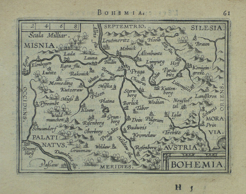
ORTELIUS (Abraham);
[REPUBLIQUE TCHEQUE] Bohemia.
Anvers 1598 81 x 105 mm.
Bookseller reference : LBW-1401
|
|
|
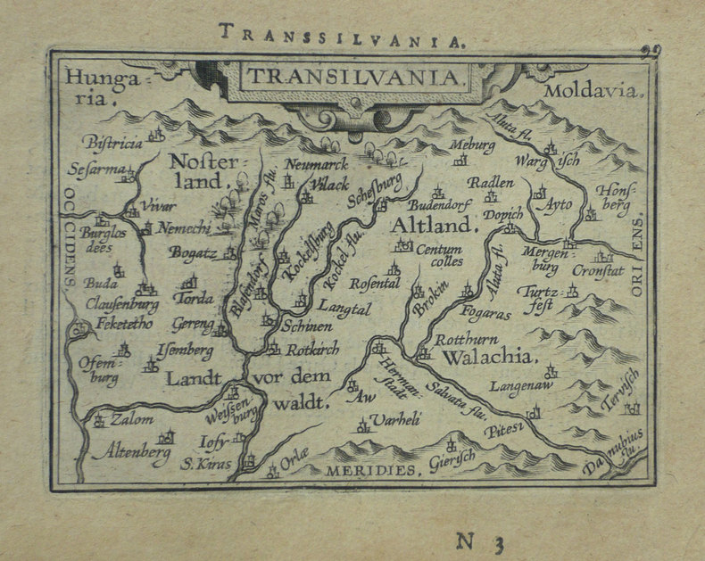
ORTELIUS (Abraham);
[ROUMANIE] Transilvania.
Anvers 1598 80 x 105 mm.
Bookseller reference : LBW-1395
|
|
|
ORTELIUS (Abraham);
[ROME] Romanum territorium.
Anvers 1598 81 x 106 mm.
Bookseller reference : LBW-1409

|
|
|
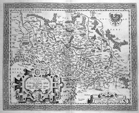
ORTELIUS (Abraham).
[SILESIE] Silesiae typus.
[Anvers, 1603]. 344 x 420 mm.
Bookseller reference : LBW02528
|
|
|
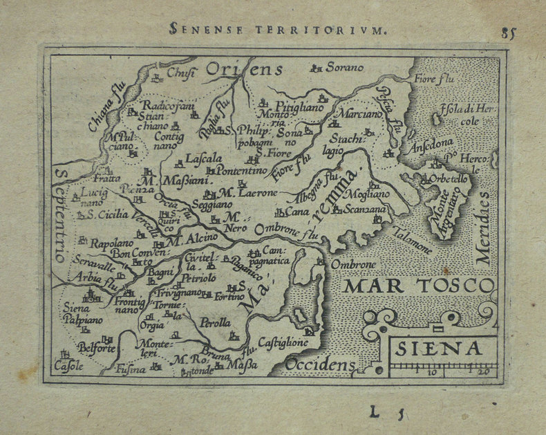
ORTELIUS (Abraham);
[SIENNE] Siena.
Anvers 1598 83 x 106 mm.
Bookseller reference : LBW-1420
|
|
 Receive by email
 Download as PDF document
 RSS feed


