|
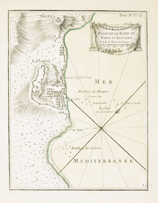
BELLIN (Jacques-Nicolas);
Plan de la rade et ville d'Alicant.
1764 227 x 176 mm.
Bookseller reference : LBW-699
|
|
|
BELLIN (Jacques-Nicolas);
Plan de St. Sebastien.
1764 222 x 178 mm.
Bookseller reference : LBW-704

|
|
|
BELLIN Jacques-Nicolas
Description géographique des débouquemens qui sont au Nord de l'Isle de SAINT DOMINGUE. Avec des Cartes et des Plans des Isles qui forment ces Passages, et des Dangers qui s'y trouvent. Pour le service des Vaisseaux du Roy. Par Ordre de M. Le Duc de PRASL
Imprimerie De Didot Paris 1768 In-4 carré ( 250 X 195 mm. ) de: [5] ff. ( Titre, Titre gravé, Table des chapitres, Table des cartes et plans ), 152 pages, pleine basane fauve marbrée, dos à nerfs orné de caissons, fleurons et roulettes dorés, pièce de titre de maroquin vieux-rouge, chaînette dorée sur les coupes, tranches brique. Joli bandeau allégorique signé Jean CHOFFARD et 34 cartes gravées dont 16 doubles ( 2 dépliantes ) par Nicolas BELLIN. Parmi les 34 cartes qui illustrent louvrage, une carte générale du Nord de St Domingue et de ses cinq débouquements, une du Canal de Bahama représentant le sud du Golfe du Mexique. Rare édition originale de ce routier des Antilles par le premier hydrographe de la Marine royale française, Jacques-Nicolas BELLIN ( 1703-1772 ). ( J. Polak 591 Sabbin, 4552 ). Reliure un peu frottée, 2 coins émoussés, mouillure claire et petite galerie de vers marginale à quelques feuillets, bon exemplaire à grandes marges.
Bookseller reference : 899943

|
|
|
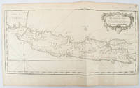
BELLIN, JACQUES-NICOLAS.
Idée de l'Isle de Java tirée des manuscripts Hollandois.
circa1750. Black and white copperplate engraving map of Java a little light even browning neat colour pencil highlighting of rivers and two settlements. Folded as issued. Good copy. 26 x 44cm. Issued in Prevost's Histoire Générale des Voyages ou nouvelle collection de toutes les relations de voyages par mer et par terre. . unknown
Bookseller reference : 136782
|
|
|
Bellin, Jacques-Nicolas
Deuxieme Carte des Isles de la Sonde. Sunda-Inseln; Java, Bali. Borneo... (1760). [Altkolorierter Kupferstich, gerahmt / handcoloured copper engraving, framed].
o.J. [3 Warenabbildungen] (Jacques-Nicolas Bellin, geb. 1703 in Paris, gest. 21. März 1772 in Versailles, französischer Kartograph, Ingenieur-Geog
Bookseller reference : 66108CB

|
|
|
Belling, Lawrence N.
Seychelles : Iles D'amour : Islands of Love (Signed By Chief Minister)
Inscribed on title page from the Chief Minister James R Mancham to Tom Pendry MP. No other marks or inscriptions to contents. No creasing to covers or to spine. A very clean very tight copy with bright cream boards, faint coloured mark to rear and no bumping to corners. 128pp. An account of the Islands of the Seychelles published for the visitor. Very well illustrated. Text in English and French.

|
|
|
BELLOGUET (André).
[JEU de l'OIE] Jeu d'oie parlementaire.
Paris, Mr Vancortenberghen, 1870. 513 x 726 mm.
Bookseller reference : LBW-8540

|
|
|
BELLY Félix:
Les sept merveilles du monde moderne.
Paris, Calmann Lévy, 1887. In-8 de VII-185-[3] pages, pleine percaline rouge richement décorée en noir et or.
Bookseller reference : 15670

|
|
|
BELMAS (Jacques-Vital) & TARDIEU (Ambroise).
[ALMEIDA] Plan du siège d'Almeida par l'armée française de Portugal en 1810.
[1836]. 596 x 878 mm.
Bookseller reference : LBW-5980

|
|
|
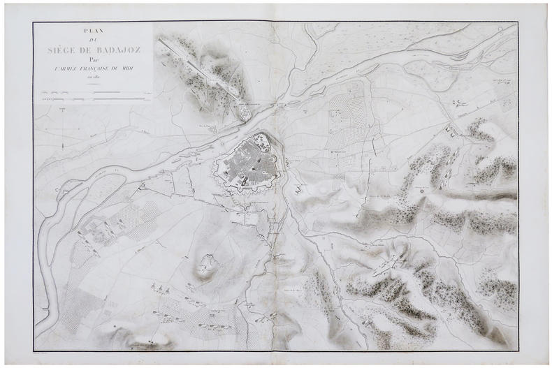
BELMAS (Jacques-Vital) & TARDIEU (Ambroise).
[BADAJOZ] Plan du siège de Badajoz par l'armée française du Midi en 1811.
[1836]. 611 x 898 mm.
Bookseller reference : LBW-5982
|
|
|
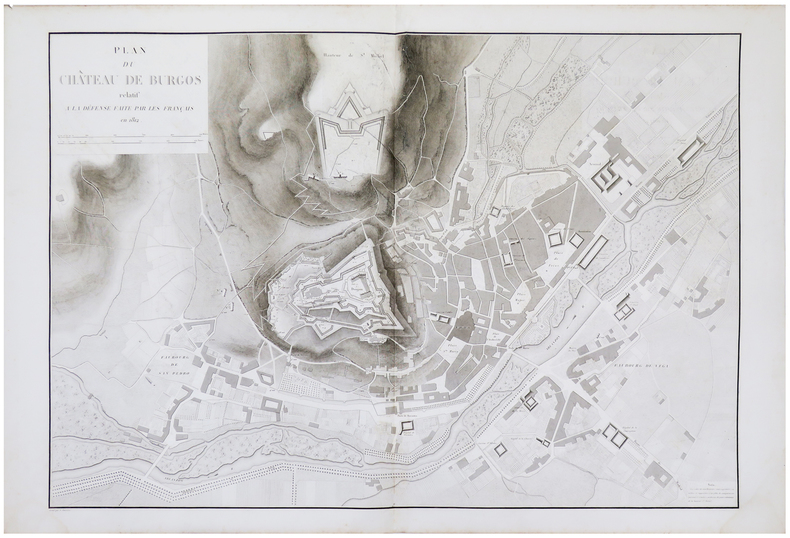
BELMAS (Jacques-Vital) & TARDIEU (Ambroise).
[BURGOS] Plan du château de Burgos relatif à la défense faite par les Français en 1812.
[1836]. 603 x 884 mm.
Bookseller reference : LBW-5985
|
|
|
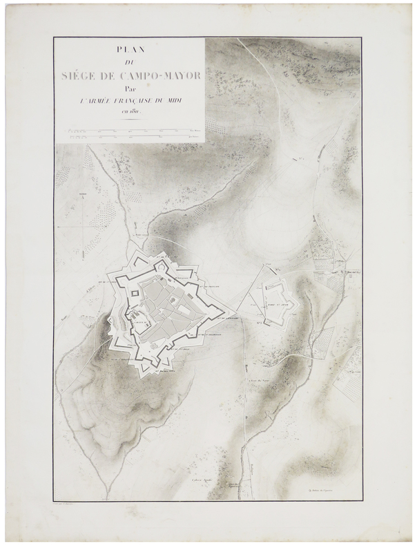
BELMAS (Jacques-Vital) & TARDIEU (Ambroise).
[CAMPO MAIOR] Plan du siège de Campo-Mayor par l'armée française du Midi en 1811.
[1836]. 578 x 380 mm.
Bookseller reference : LBW-5897
|
|
|
BELMAS (Jacques-Vital) & TARDIEU (Ambroise).
[CASTRO-URDIALES] Plan du siège de Castro-Urdiales par l'armée française du Nord en 1813.
[1836]. 597 x 397 mm.
Bookseller reference : LBW-5976

|
|
|
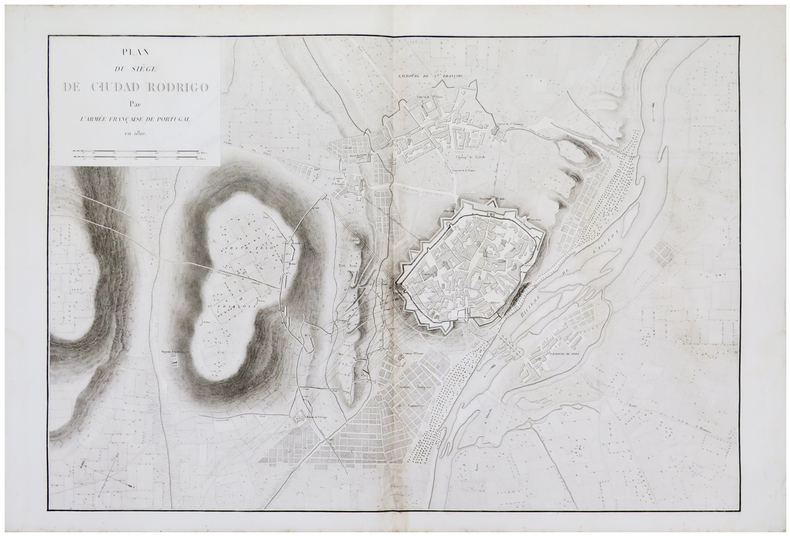
BELMAS (Jacques-Vital) & TARDIEU (Ambroise).
[CIUDAD RODRIGO] Plan du siège de Ciudad Rodrigo par l'armée française de Portugal en 1810.
[1836]. 602 x 890 mm.
Bookseller reference : LBW-5983
|
|
|
BELMAS (Jacques-Vital) & TARDIEU (Ambroise).
[MONZÓN] Plan du fort de Monzon relatif à la défense faite par les Français en 1813 et 1814.
[1836]. 596 x 397 mm.
Bookseller reference : LBW-5978

|
|
|
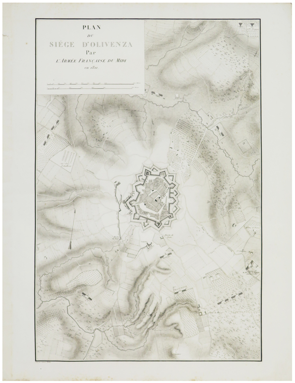
BELMAS (Jacques-Vital) & TARDIEU (Ambroise).
[OLIVENZA] Plan du siège d'Olivenza par l'armée française du Midi en 1811.
[1836]. 602 x 389 mm.
Bookseller reference : LBW-5898
|
|
|
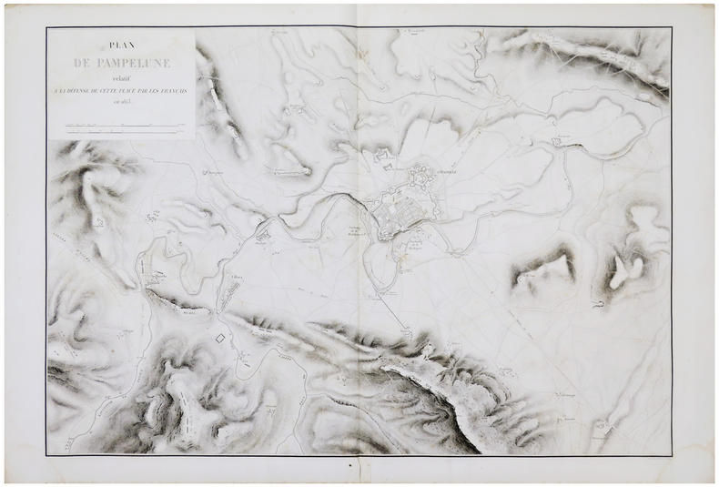
BELMAS (Jacques-Vital) & TARDIEU (Ambroise).
[PAMPELUNE] Plan de Pampelune relatif à la défense de cette place par les Français en 1813.
[1836]. 598 x 879 mm.
Bookseller reference : LBW-5981
|
|
|
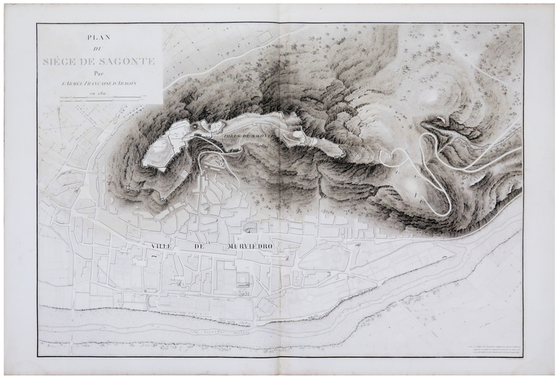
BELMAS (Jacques-Vital) & TARDIEU (Ambroise).
[SAGONTE] Plan du siège de Sagonte par l'armée française d'Aragon en 1811.
[1836]. 604 x 889 mm.
Bookseller reference : LBW-5979
|
|
|
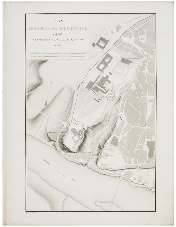
BELMAS (Jacques-Vital) & TARDIEU (Ambroise).
[SALAMANQUE] Plan des forts de Salamanque relatif à la défense faite par les Français en 1812.
[1836]. 594 x 392 mm.
Bookseller reference : LBW-5879
|
|
|
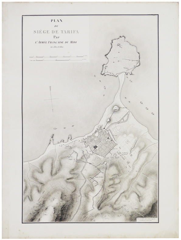
BELMAS (Jacques-Vital) & TARDIEU (Ambroise).
[TARIFA] Plan du siège de Tarifa par l'armée française du Midi en 1811 et 1812.
[1836]. 590 x 388 mm.
Bookseller reference : LBW-5977
|
|
|
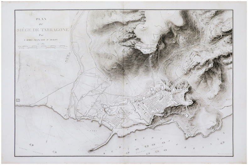
BELMAS (Jacques-Vital) & TARDIEU (Ambroise).
[TARRAGONE] Plan du siège de Tarragone par l'armée française d'Aragon en 1811.
[1836]. 603 x 892 mm.
Bookseller reference : LBW-5984
|
|
|
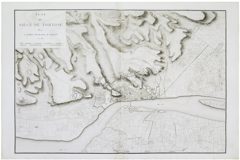
BELMAS (Jacques-Vital) & TARDIEU (Ambroise).
[TORTOSA] Plan du siège de Tortose par l'armée française d'Aragon en 1810.
[1836]. 607 x 897 mm.
Bookseller reference : LBW-5986
|
|
|
Ben Younes, Alia and Habib
All Tunisia : Collection All Africa
Very faint marking to title page. No other marks or inscriptions. Creasing and minor rubbing to covers. Very clean very tight pages. 128pp. History and tourist guide to Tunisia, very well illustrated.

|
|
|
BENARD Robert (Parigi 1734-1777)
Carte Reduite du Globe Terrestre
Mappa del mondo, basata sulla proiezione di Mercator, disegnata da Seguin e pubblicata da Robert Benard.Incisa da J. B. L. Aubert, la mappa fa parte dei Voyages autour du Monde et vers les deux Poles par Terre et par Mer, di Pierre Marie François de Pages, stampato nel 1782.Nato da una famiglia nobile, l'ufficiale di marina francese Pierre Marie François de Pages fece un viaggio di cinque anni in tutto il mondo, tra il 1767 e il 1771. Successivamente partecipò a un viaggio di due anni al Polo Sud, tra il 1773 e il 1774. Alla fine ho fatto un viaggio al Polo Nord nel 1776. Questi viaggi sono stati raccontati nella sua pubblicazione del 1782.Incisione in rame, solite pieghe di carta, altrimenti in buone condizioni. Map of the World on Mercator's projection by Seguit and Robert Benard.Engraved by J. B. L. Aubert the map is part of the Voyages autour du Monde et vers les deux Poles par Terre et par Mer, by Pierre Marie François de Pages, printed in 1782.Born of noble family, a French naval officer, Pierre Marie François de Pages, made a five-year voyage around the world, between 1767 and 1771. Subsequently he took part in a two year voyage to the South Pole, between 1773 and 1774. Finally he made a trip to the North Pole in 1776. These voyages were recounted in his publication of 1782. Engraving, usual folds, otherwise in good condition.

|
|
|
BENARD, ROBERT (ENGRAVER), AFTER PHILIP CARTERET (MAPMAKER).
Banc de Sable Dangereux. on sheet with Isles de Joseph Freewill and L'Extremité Méridionale de Mindanao.
A Paris.: Chez Saillant et Nyon rue Saint-Jean-de-Beauvais Chez Panckoucke Hotel de Thou rue des Poitevins. 1774. Engraved map on laid paper 27.2 x 19.9cm 26.5 x 22.2cm sheet size edge fold slight marginal toning but in very good condition. Map of the treacherous coastal waters sandbars submerged rocks and reefs surrounding Mindanao and the Joseph Freewill Islands Mapia Atoll in the Philippines finely re-engraved for the French edition of Captain James Cook's First Voyage 1768-1771 "Relation des voyages.pour faire des decouvertes dans l'hemisphere meridional et successivement executes par le commodore Byron le capitaine Carteret le capitaine Wallis & le capitaine Cook.". . Chez Saillant et Nyon, rue Saint-Jean-de-Beauvais, [Chez] Panckoucke, Hotel de Thou, rue des Poitevins. unknown
Bookseller reference : 174260
|
|
|
BENARD, ROBERT (ENGRAVER), AFTER PHILIP CARTERET (MAPMAKER).
Vue de la Baye de Bonthain située à environ 30. lieues au S.E. de Macassar dans l'Isle des Celebes latit. 5d. 34" S.
Paris.: Chez Saillant et Nyon rue Saint-Jean-de-Beauvais Chez Panckoucke Hotel de Thou rue des Poitevins. 1774. Engraved map on laid paper 18.5 x 31cm 25.6 x 34.4cm sheet size central fold slight marginal toning but a very good dark impression. Map of Bonthain Bay situated southeast of Macassar on the island of Celebes finely re-engraved for the French edition of Captain James Cook's First Voyage 1768-1771 "Relation des voyages.pour faire des decouvertes dans l'hemisphere meridional et successivement executes par le commodore Byron le capitaine Carteret le capitaine Wallis & le capitaine Cook.". . Chez Saillant et Nyon, rue Saint-Jean-de-Beauvais, [Chez] Panckoucke, Hotel de Thou, rue des Poitevins. unknown
Bookseller reference : 174257
|
|
|
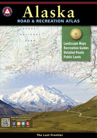
Benchmark Maps & Atlases
Alaska Benchmark Road & Recreation 2016 Atlas
Benchmark Maps 2016. Paperback. New. 2016 edition. 144 pages. 15.50x10.80x0.50 inches. Benchmark Maps paperback
Bookseller reference : 1-0929591143 ISBN : 0929591143 9780929591148
|
|
|
Benchmark Maps and Atlases
Alaska Road & Recreation Atlas Benchmark Recreation Atlases
Benchmark Maps 2016-01-01. 2016. map. Used: Good. 10.50x0.50x15.20. Buy with confidence. Excellent Customer Service & Return policy. Benchmark Maps unknown
Bookseller reference : SONG0929591143 ISBN : 0929591143 9780929591148
|
|
|
Benchmark Maps (Firm)
Albuquerque & Santa Fe street atlas
Benchmark Maps 2001. Paperback. Acceptable. Readable copy. Pages may have considerable notes/highlighting. ~ ThriftBooks: Read More Spend Less.Dust jacket quality is not guaranteed. Benchmark Maps paperback
Bookseller reference : G0929591720I5N00 ISBN : 0929591720 9780929591728
|
|
|
Benchmark Maps (Firm)
Albuquerque & Santa Fe street atlas
paperback. Good. Access codes and supplements are not guaranteed with used items. May be an ex-library book. paperback
Bookseller reference : 0929591720.G ISBN : 0929591720 9780929591728
|
|
|
Benchmark Maps and Atlases
Arizona Recreation Map Benchmark Maps
map. Good. Access codes and supplements are not guaranteed with used items. May be an ex-library book. unknown
Bookseller reference : 0783499094.G ISBN : 0783499094 9780783499093
|
|
|
Benchmark Maps and Atlases
Arizona Recreation Map Benchmark Maps
Benchmark Maps 2017-01-01. 2017. map. New. 4.25x0.20x9.00. Buy with confidence. Excellent Customer Service & Return policy. Benchmark Maps unknown
Bookseller reference : DADAX0783499094 ISBN : 0783499094 9780783499093
|
|
|
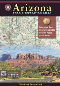
Benchmark Maps
Arizona Road & Recreation Atlas - 13th Edition 2024 Benchmark Road & Recreation Atlases
Benchmark Maps 2024. Soft cover. New. Arizona Maps/Travel YOUR PURCHASE SUPPORTS A SMALL BUSINESS!! Benchmark Maps paperback
Bookseller reference : 018361 ISBN : 9798986387915 9798986387
|
|
|
Benchmark Maps
Arizona Road & Recreation Atlas - 13th Edition 2024 Benchmark Road & Recreation Atlases
Benchmark Maps 2024-01-01. 13th Edition 2024. paperback. Used: Good. 11.00x0.50x15.00. Buy with confidence. Excellent Customer Service & Return policy. Benchmark Maps paperback
Bookseller reference : SONGB0CBQHWBQ8
|
|
|
Benchmark Maps
Arizona Road & Recreation Atlas - 13th Edition 2024 Benchmark Road & Recreation Atlases
Benchmark Maps 01-01-2024. 13th Edition 2024. paperback. New. 11.00x0.50x15.00. Buy with confidence. Excellent Customer Service & Return policy. Benchmark Maps paperback
Bookseller reference : DADAXB0CBQHWBQ8
|
|
|
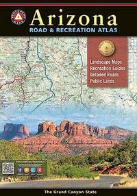
Benchmark Maps
Arizona Road and Recreation Atlas
Spiral bound. New. New Book; Fast Shipping from UK; Not signed; Not First Edition; The Grand Canyon State abounds in natural beauty and outdoor recreation possibilities. Completely reworked with new Landscape Maps and a comprehensive Recreation Guide our Arizona Road and Recreation Atlas is an invaluable resource for unknown
Bookseller reference : ria9798986387918_inp ISBN : 9798986387915 9798986387
|
|
|
Benchmark Maps and Atlases
Arizona Road & Recreation Atlas Benchmark Recreation Atlases
Benchmark Maps 2018-01-05. 2018. map. Used: Good. 10.75x0.25x15.25. Buy with confidence. Excellent Customer Service & Return policy. Benchmark Maps unknown
Bookseller reference : SONG0929591186 ISBN : 0929591186 9780929591186
|
|
|
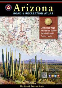
Benchmark Maps
Arizona Road and Recreation Atlas - 12th Edition 2021 Benchmark
Benchmark Maps 2021-06-15. 12th Edition 2021. paperback. New. 10.70x0.80x15.30. Buy with confidence. Excellent Customer Service & Return policy. Benchmark Maps paperback
Bookseller reference : DADAX1734315040 ISBN : 1734315040 9781734315042
|
|
|
Benchmark Maps
Arizona Road and Recreation Atlas - 12th Edition 2021 Benchmark
Benchmark Maps 2021-06-15. 12th Edition 2021. paperback. Used: Good. 10.70x0.80x15.30. Buy with confidence. Excellent Customer Service & Return policy. Benchmark Maps paperback
Bookseller reference : SONG1734315040 ISBN : 1734315040 9781734315042
|
|
|
Benchmark Maps
Arizona Road and Recreation Atlas - 12th Edition 2021 Benchamrk Maps
paperback. Good. Access codes and supplements are not guaranteed with used items. May be an ex-library book. paperback
Bookseller reference : 1734315040.G ISBN : 1734315040 9781734315042
|
|
|
Benchmark Maps and Atlases
Arizona Road & Recreation Atlas Benchmark Recreation Atlases
Benchmark Maps 2018-01-05. 2018. map. New. 10.75x0.25x15.25. Buy with confidence. Excellent Customer Service & Return policy. Benchmark Maps unknown
Bookseller reference : DADAX0929591186 ISBN : 0929591186 9780929591186
|
|
|
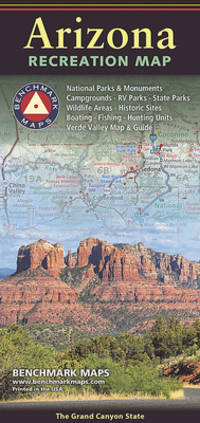
Benchmark Maps
Arizona The Grand Canyon State Recreation Map 2024 Edition Benchmark
Benchmark Maps 2024. Map Fold. New. Arizona Maps/Travel YOUR PURCHASE SUPPORTS A SMALL BUSINESS!! Benchmark Maps unknown
Bookseller reference : 018360 ISBN : 078349971x 9780783499710
|
|
|
Benchmark Maps
Arizona The Grand Canyon State Recreation Map 2024 Edition Benchmark
Benchmark Maps 2024-06-15. 2024th ed. map. Used: Good. 4.00x0.20x9.00. Buy with confidence. Excellent Customer Service & Return policy. Benchmark Maps unknown
Bookseller reference : SONG078349971X ISBN : 078349971X 9780783499710
|
|
|
Benchmark Maps
Arizona The Grand Canyon State Recreation Map 2024 Edition Benchmark
Benchmark Maps 15-06-2024. 2024th ed. map. New. 4.00x0.20x9.00. Buy with confidence. Excellent Customer Service & Return policy. Benchmark Maps unknown
Bookseller reference : DADAX078349971X ISBN : 078349971X 9780783499710
|
|
|
Benchmark Maps
Arizona The Grand Canyon State Recreation Map 2024 Edition
map. Good. Access codes and supplements are not guaranteed with used items. May be an ex-library book. unknown
Bookseller reference : 078349971X.G ISBN : 078349971X 9780783499710
|
|
|
Benchmark Maps
Arkansas Recreation Map
map. Good. Access codes and supplements are not guaranteed with used items. May be an ex-library book. unknown
Bookseller reference : 0783499272.G ISBN : 0783499272 9780783499277
|
|
|
Benchmark Maps
Atlas WYOMING ROAD RECREATION
Natl Geographic Society Maps. New. BRAND NEW GIFT QUALITY! NOT OVERSTOCKS OR MARKED UP REMAINDERS! DIRECT FROM THE PUBLISHER! Natl Geographic Society Maps unknown
Bookseller reference : OTF-9780929591797 ISBN : 0929591798 9780929591797

|
|
|
Benchmark Maps
Baja California Road and Recreation Atlas - 2nd Edition 2024 Benchmark
Benchmark Maps 2024-01-01. 2nd Edition 2024. map. New. 10.60x0.50x15.10. Buy with confidence. Excellent Customer Service & Return policy. Benchmark Maps unknown
Bookseller reference : DADAX1734315059 ISBN : 1734315059 9781734315059
|
|
|
Benchmark Maps
Baja California Road and Recreation Atlas - 2nd Edition 2024 Benchmark
Benchmark Maps 2024-01-01. 2nd Edition 2024. map. Used: Good. 10.60x0.50x15.10. Buy with confidence. Excellent Customer Service & Return policy. Benchmark Maps unknown
Bookseller reference : SONG1734315059 ISBN : 1734315059 9781734315059
|
|
|
Benchmark Maps
Benchmark Wyoming Road and Recreation Atlas
Benchmark Maps 2007. Paperback. Like New. Pages are clean and are not marred by notes or folds of any kind. ~ ThriftBooks: Read More Spend Less.Dust jacket quality is not guaranteed. Benchmark Maps paperback
Bookseller reference : G0929591968I2N00 ISBN : 0929591968 9780929591964
|
|
 Receive by email
 Download as PDF document
 RSS feed


