|
BELL D'ANTERMONY (Jean) , LANGE (Lorenz)
Voyages entre Saint-Pétersbourg et la Russie, dans divers pays d'Asie.
Paris, Robin, 1766. 3 volumes in-12, veau marbré, dos là nerfs orné (Reliure de l'époque) avec pièce de titre et tomaison , tranches rouges , ex-libris sur le contre-plat , défauts de reliure , coins et coiffes usés , début de fentes aux charnières , etc.
Bookseller reference : PHO-1265

|
|
|
Bell, Leonard M.; Kallman, Ronald J.
The Nanaimo River Estuary: Status of Environmental Knowledge to 1976 - Special Estuary Series No. 5
298 pages including index. Compiles all available references relevant to the environmental aspect of the Nanaimo River Estuary. Summarizes pertinent information and provides lists on plant and animal life, to provide readers with some idea of the ecological characteristics. Contents include topics such as: Geology; Economic Geology; Surficial Geology; Climatology; Hydrology; Oceanography; Invertebrate Biology; Invertebrate Fisheries Resource; Flora; Wildlife; Land and Water Use; Pollution; plus an extensive Bibliography. Includes a variety of maps. Report of the Estuary Working Group, Department of the Environment, Regional Pacific Region. Clean and unmarked with moderate wear. Binding sound. A wonderful reference. Book
|
|
|
Bell, Timothy: Editor
Bell's Mile By Mile Alaska Yukon and British Columbia Travel Guide
432 pages including index. All towns and highways described in detail mile-by-mile. Accommodations. Campgrounds. Emergency Services. Ferry Information. City maps. Alaska Railroad. Local History. What to see and do. Underlining and marginalia upon several pages. Very light wear. Attractive colour glossy covers. Please note: fold-out map not included. Book
|
|
|
Bella Terra Maps
Southeastern Lighthouses Map Pack - North Carolina South Carolina Georgia & Florida
NEW. unknown
Bookseller reference : BIB-NOV-15-2025-146694 ISBN : 1888216603 9781888216608
|
|
|
Bellah, James Warner. (Text) Pratt, Fletcher. (Foreword) Palacios, Rafael. (Maps)
THE VALIANT VIRGINIANS.
NY: BALLANTINE BOOKS. Near Fine in Very Good dust jacket. 1953. First Edition. Hardcover. Near fine in a Vg. dj. Barely discernable 2"-inch tear at upper seam of rear panel of dj. A few short edge tears & small chips as well as traces of shelfsoiling to dj. Novel of the Virginia Calvary in the Shenandoah Valley during the Civil War. LR . BALLANTINE BOOKS. hardcover
Bookseller reference : 309567
|
|
|
Bellamy, Joyce and Others
Hampstead Heath Flora : Habitat Handbook No 1
No marks or inscriptions to contents. Faint creasing to front cover. A very clean very tight copy with bright slightly indented front board and no bumping to corners. 60pp. With over 200 habitat maps of Hampstead Heath for different plant species, a detailed index and plant records. Includes seven other tucked-in A4 leaflets on the history and wildlife of Hampstead Heath.

|
|
|
BELLANGER (Pierre).
Physiologie du bridge.
P., Plon, 1931, 1 vol. in-8 br. de VIII - 491 pp.
Bookseller reference : 3734
|
|
|
BELLANGER Pierre
Physiologie du bridge
Plon 1931, In-8 broché, viii + 492 pages. Exemplaire non coupé. Petites salissures à la couverture sans gravité. Bon état.
|
|
|
BELLANGER, Pierre
PHYSIOLOGIE DU BRIDGE
Paris Librairie Plon 1931 in 8 (22,5x14) 1 volume reliure demi basane marron à coins, couverture conservée, VIII et 491 pages (reliure signée: P. Ruffel, relieur). Bon exemplaire
Bookseller reference : 15532
|
|
|
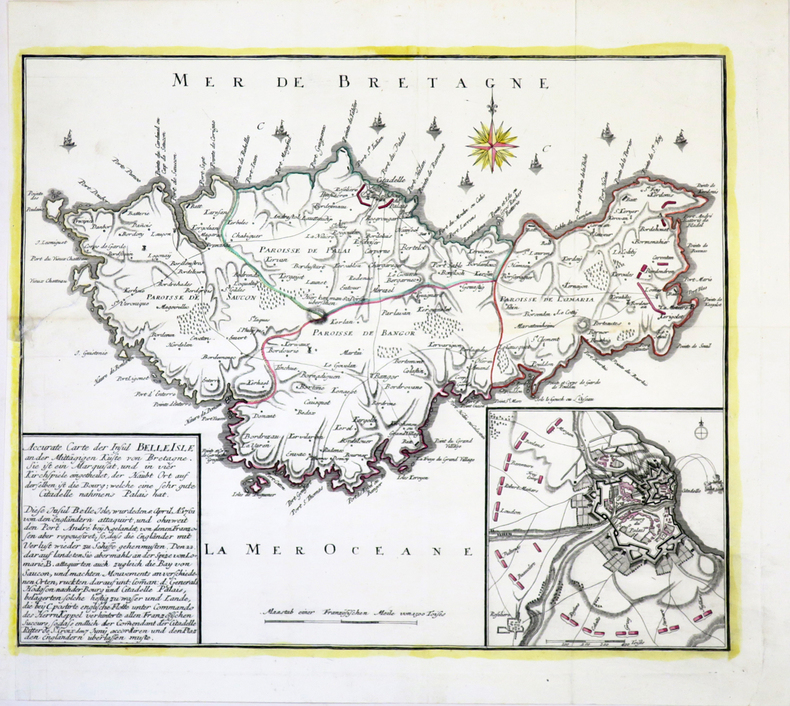
BELLE-ÎLE-en-MER.
Accurate Carte der Insul Belle Isle an der mittägigen Küste von Bretagne.
[circa 1761]. 365 x 435 mm.
Bookseller reference : LBW-4005
|
|
|
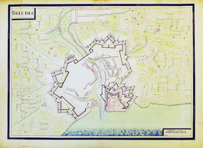
BELLE-ÎLE-en-MER. MANUSCRIT.
Bell'Isle.
[circa 1700]. 480 x 660 mm.
Bookseller reference : LBW-4187
|
|
|
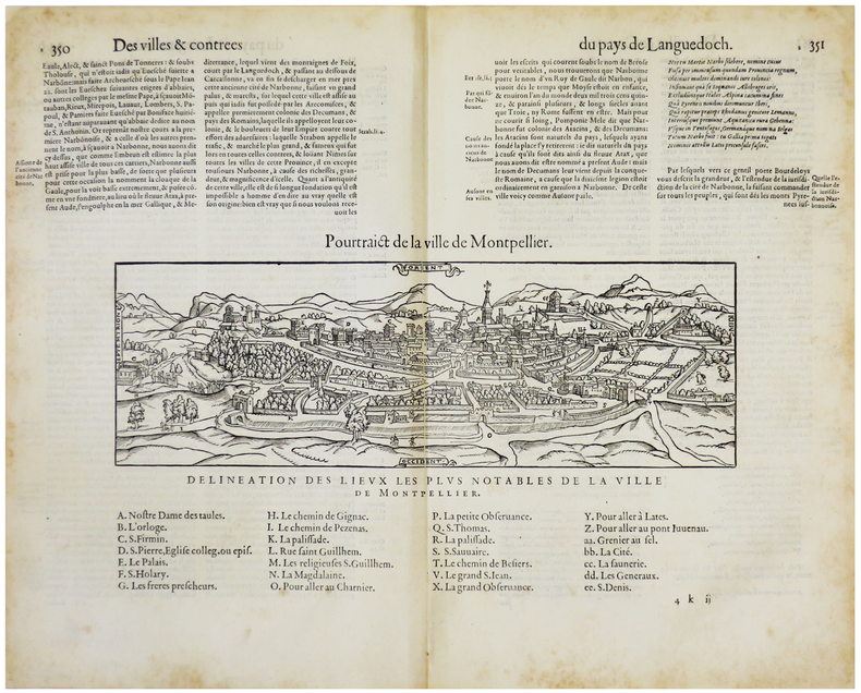
BELLEFOREST (François de).
[MONTPELLIER] Pourtraict de la ville de Montpellier.
[Paris, Nicolas Chesneau, 1575]. 176 x 310 mm (vue et légendes).
Bookseller reference : LBW-5507
|
|
|
BELLEFOREST (François de).
La ville, cité, université, & faux-bourgs de Paris.
[Paris, Nicolas Chesneau, 1575]. 422 x 551 mm.
Bookseller reference : LBW-8239

|
|
|
BELLEFOREST (François de).
Le Pourtraict de la Ville de Rouen.
Paris, Nicolas Chesneau, 1575. Gravure sur bois de 40 cm x 33 cm, légende avec lettres et numéros dans la marge inférieure désignant les rues et monuments, texte en français au verso. Très bon état. Sous verre dans un cadre moderne en chêne foncé, 53 x 47 cm.
Bookseller reference : 20642

|
|
|
Belleyme
CARTES DE PIERRE BELLEYME.
Cartes originales de Belleyme toilées.35 de 90cm/56. 16 1/2 de 45cm/59.Numéros: 3.8.9.10.14.15.22.24.28.29.30.31.Bon état.
Bookseller reference : 50736
|
|
|
BELLEYME (Pierre de).
[AQUITAINE] Carte de la Généralité d'Aquitaine dédiée à Monsieur de Néville, intendant de la province.
1787. En trois feuilles coupées en 40 sections montées sur toile et repliées, formant une carte de 1,31 x 1,50 m.
Bookseller reference : LBW-8939

|
|
|
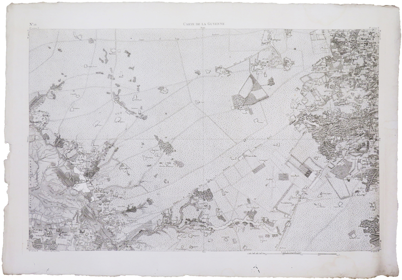
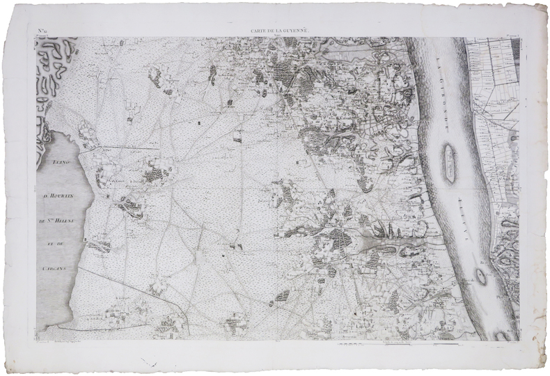
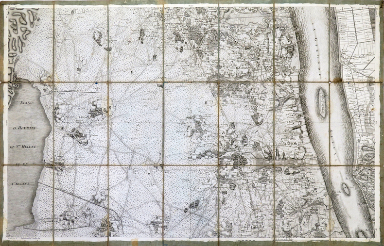
BELLEYME (Pierre de).
[BASSIN d'ARCACHON] Carte de la Guyenne [dite Carte de Belleyme]. Feuille n°26 (Le Teich).
[1785]. 585 x 895 mm.
Bookseller reference : LBW-7565
|
|
|
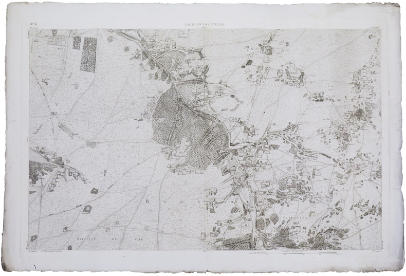
BELLEYME (Pierre de).
[DORDOGNE] Carte de la Guyenne [dite Carte de Belleyme]. Feuille n°29.
[1785]. 590 x 903 mm.
Bookseller reference : LBW-7539

|
|
|
BELLEYME (Pierre de).
[GIRONDE] Carte de la Guyenne [dite Carte de Belleyme]. Feuille n°21.
[1785]. 585 x 900 mm.
Bookseller reference : LBW-7544

|
|
|
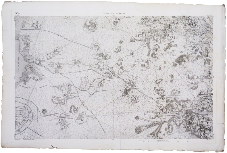
BELLEYME (Pierre de).
[GIRONDE] Carte de la Guyenne [dite Carte de Belleyme]. Feuille n°13.
[1785]. 580 x 894 mm.
Bookseller reference : LBW-7556

|
|
|
BELLEYME (Pierre de).
[GIRONDE] Carte de la Guyenne [dite Carte de Belleyme]. Feuille n°34.
[1785]. 580 x 892 mm.
Bookseller reference : LBW-7603

|
|
|
BELLEYME (Pierre de).
[GIRONDE] Carte de la Guyenne [dite Carte de Belleyme]. Feuille n°35.
[1785]. 590 x 902 mm.
Bookseller reference : LBW-7604

|
|
|
BELLEYME (Pierre de).
[LANDES] Carte de la Guyenne [dite Carte de Belleyme]. Feuille n°33.
[1785]. 585 x 895 mm.
Bookseller reference : LBW-7567
|
|
|
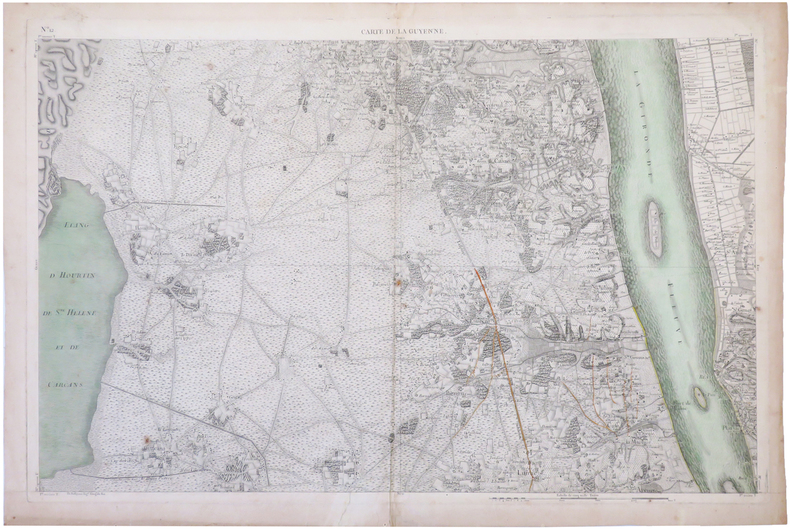
BELLEYME (Pierre de).
[MÉDOC/LACANAU] Carte de la Guyenne [dite Carte de Belleyme]. Feuille n°19.
[1785]. 590 x 895 mm.
Bookseller reference : LBW-7605
|
|
|
BELLEYME (Pierre de).
[MÉDOC] Carte de la Guyenne [dite Carte de Belleyme]. Feuille n°12 (Blaye, Fort Médoc, Pauillac).
[1785]. 575 x 893 mm.
Bookseller reference : LBW-6657
|
|
|
BELLEYME (Pierre de).
[MÉDOC] Carte de la Guyenne [dite Carte de Belleyme]. Feuille n°12 (Blaye, Fort Médoc, Pauillac).
[1785]. 585 x 895 mm.
Bookseller reference : LBW-7580
|
|
|
BELLEYME (Pierre de).
[MÉDOC] Carte de la Guyenne dite Carte de Belleyme. Feuille n°12 (Blaye, Fort Médoc, Pauillac).
[1785]. En 21 sections montées sur toile de 605 x 950 mm.
Bookseller reference : LBW-4511
|
|
|
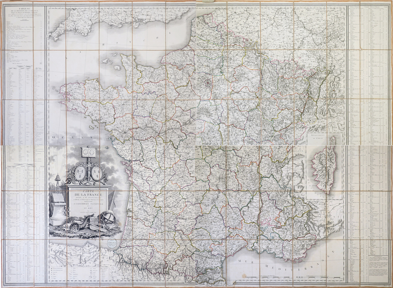
BELLEYME (Pierre de).
Carte de la France divisée en 108 départements, et subdivisée en arrondissemens communaux présentée à l'Assemblée Nationale. Corrigée en l'an VIII.
Paris, M. de Belleyme, 1791-1800 [1802]. En 40 sections montées sur toile et pliées, formant une carte de 1,31 x 1,63 m ; onglet de vélin portant le titre manuscrit ; étiquette au dos de l'éditeur parisien Goujon ; sous étui de papier marbré vert avec titre à froid sur le premier plat.
Bookseller reference : LBW-6945
|
|
|
BELLEYME (Pierre de).
Carte de la France divisée en 83 départements et subdivisée en districts avec les chefs-lieux de cantons présentée à l'Assemblée Nationale et au Roi.
Paris, Vignon, 1791. En 4 feuilles non jointes, coupées en sections montées sur toile et pliées, formant une carte de 1,15 x 1,58 m ; étiquette en forme de médaillon de l'éditeur parisien Vignon, collée sous le titre, onglets de vélin numérotés.
Bookseller reference : LBW-4323
|
|
|
BELLICAUD (Docteur).-
Nouveau traité de Bridge-Plafond. Edition nouvelle entièrement refondue et considérablement augmentée.
P., Stock, 1931, in 12 broché, 327pp. ; couverture fanée.
Bookseller reference : 30821
|
|
|
BELLIN JACQUES NICOLAS. CARTOGRAPHER.
Carte De La Baye De Chin-Chew ou Chang-Chew.
Paris. circa1749. Black and white engraved map of Quanzhou and Zhangzhou 21.1 x 30 cm here spelled Chin-chew and Chang-chew and both final words with added superscript "ou" on watermarked laid paper 25.6 x 38 cm original folds a few marginal spots simplified compass rose and a decorative fleur de lis bottom right in very good condition. Attractive map including the estuary of Quanzhou River Xiamen Emowi and Kinmen or Quemoy Quemowi island. The map was designed by the eminent French cartographer Jacques-Nicolas Bellin and here published as plate No. 22 in the impressive 15 volume compilation of voyages "Histoire Generale des Voyages" by Antoine François Prévost. . unknown
Bookseller reference : 136795
|
|
|
BELLIN JACQUES NICHOLAS CARTOGRAPHER.
Carte de L'isle de Cheu-Chan ou Isle de Chusan de la Province de Che-Kiang Avec les Costes et Isles voisines.
Paris. circa1749. Black and white engraved map on watermarked laid paper 20.9 x 32.7cm showing coastal area of Zhejiang Province Province de Che-kiang including Zhoushan Archipelago Isle de Chusan Zhoushan Bay Bay de Chusan and Xiangshan County Siang-chan-luen a walled city outside of upper border Ningbo Ning-po prefecture under Qing administration title cartouche lower left original folds. This map is No. 3 Vol. 6 from the impressive 15-volume "Histoire Generale des Voyages" compiled by Antoine François Prévost. Even browning mainly to the sheet edges in very good condition. . unknown
Bookseller reference : 136826
|
|
|
BELLIN JACQUES NICOLAS COMPAGNON PIERRE.
Grundriss von dem Eylande Goree nach den Zeichnungen des Hrn Compagnon.
Leipzig.: Schwabe Johann Joachim. 1748. Engraved map on laid paper 20.5 x 36 cm plate -mark inc. captions 24 x 39 cm sheet size original fold later hand-colouring slight marginal spotting but in very good condition. Fine 18th century ground plan of Gorée Island off the coast of Senegal infamous for its association with slavery. The map shows encampments and forts with a detailed key. Originally published in Abbe Prevost's "Histoire générale des voyages." 1746 -1789 with maps and plans by the great cartographer Jacques-Nicolas Bellin this was prepared for volume two of the the German edition "Allgemeine Historie der Reisen." published in 1748. . (Schwabe, Johann Joachim) unknown
Bookseller reference : 175859
|
|
|
BELLIN (Jacques Nicolas).
PLAN DE ROUEN ET DES ENVIRONS.
S. l., Croisey (graveur), sd. (1764). Plan gravé de 23,5 x 34,5 cm (cuvette), avec de belles marges et rehauts de couleurs.
Bookseller reference : 9372
|
|
|
BELLIN (Jacques Nicolas).
PLAN DE ROUEN ET DES ENVIRONS.
S. l., Croisey (graveur), sd. (1764). Plan gravé de 23,5 x 34,5 cm (cuvette), avec marges.
Bookseller reference : 9375
|
|
|
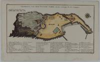
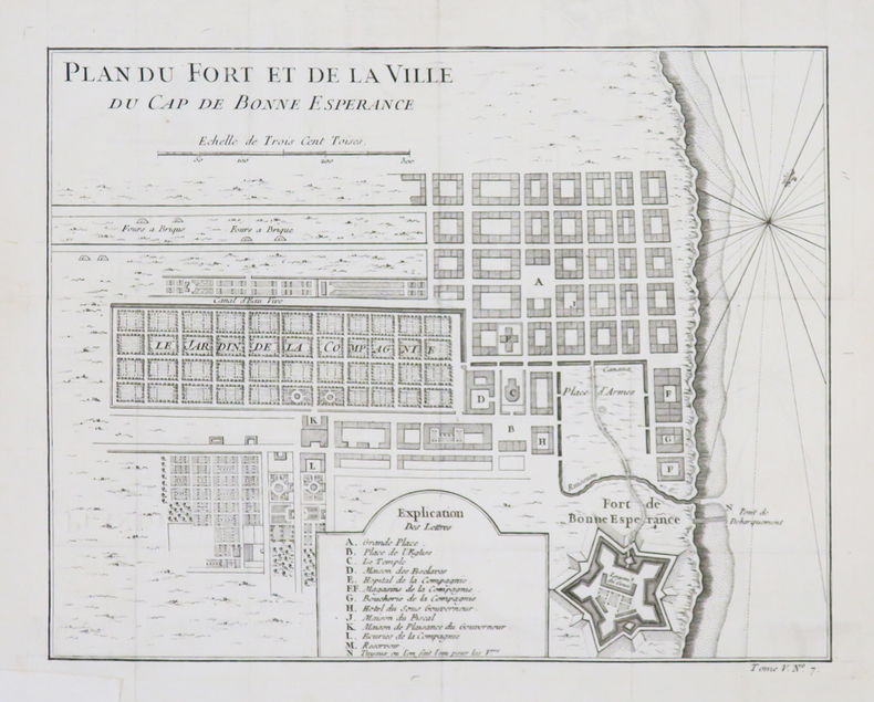
BELLIN (Jacques-Nicolas).
[AFRIQUE du SUD/LE CAP] Plan du fort et de la ville du Cap de Bonne Espérance.
[circa 1760]. 209 x 265 mm.
Bookseller reference : LBW-4532
|
|
|
BELLIN (Jacques-Nicolas).
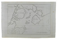
[AFRIQUE DU SUD] Carte de la baye de Saldana ou Saldane.
[circa 1760]. 200 x 278 mm.
Bookseller reference : LBW024b7
|
|
|
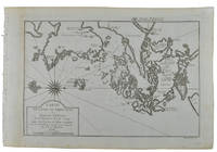
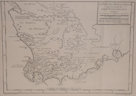
BELLIN (Jacques-Nicolas).
[AFRIQUE DU SUD] Le pays des Hottentots aux environs du Cap de Bonne Espérance.
[circa 1760]. 245 x 348 mm.
Bookseller reference : LBW024b8
|
|
|
BELLIN (Jacques-Nicolas).
[ALGERIE] Plan de la ville forts et port d'Alger.
[1764]. 211 x 169 mm.
Bookseller reference : LBW01b58
|
|
|
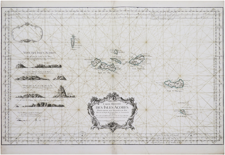
BELLIN (Jacques-Nicolas).
[AÇORES] Carte réduite des Isles Açores.
Paris, M. Bellin, 1755. 557 x 897 mm.
Bookseller reference : LBW-8147
|
|
|
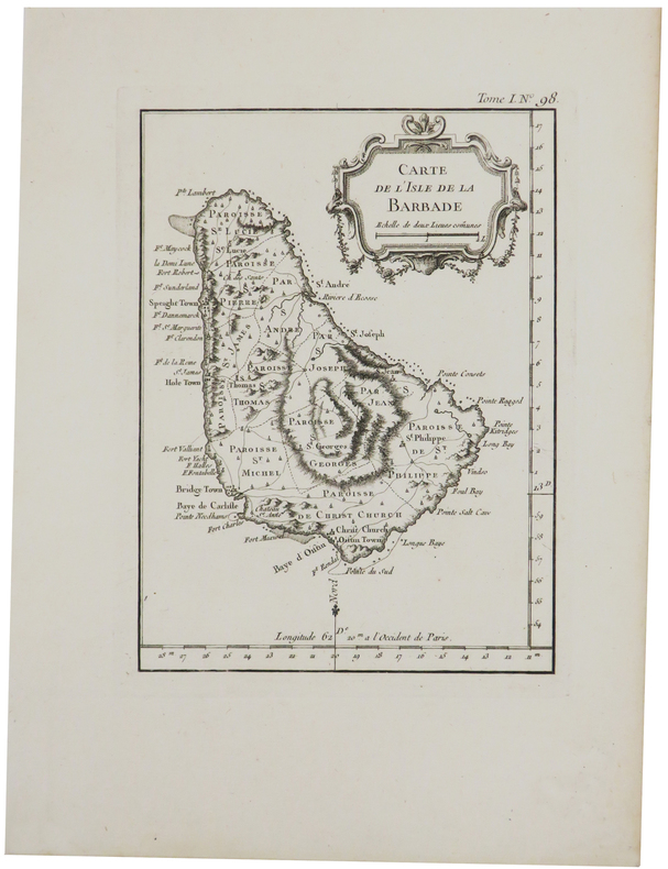
BELLIN (Jacques-Nicolas).
[BARBADE] Carte de l'isle de la Barbade.
1764. 200 x 147 mm.
Bookseller reference : LBW-2370
|
|
|
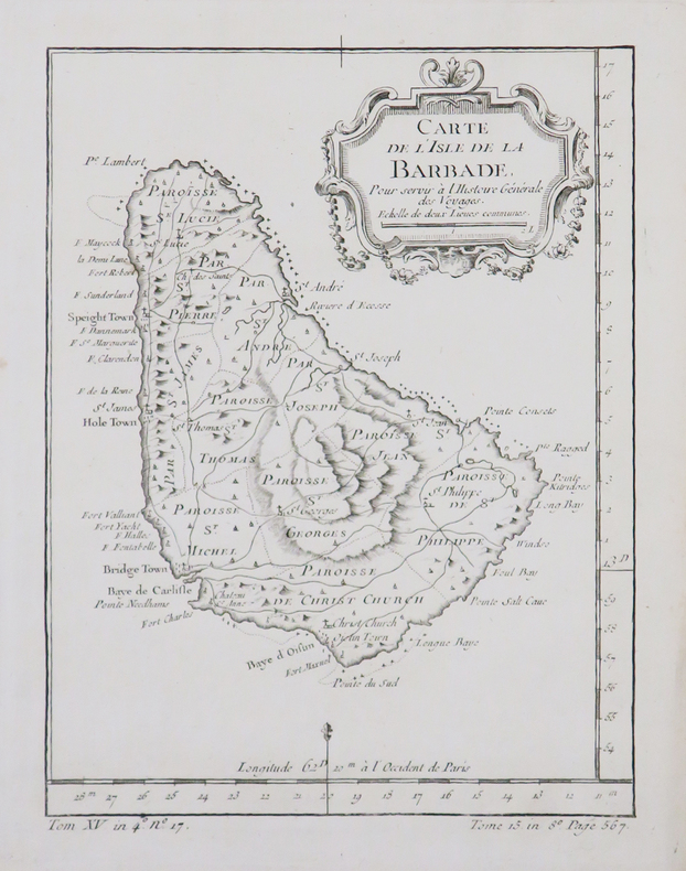
BELLIN (Jacques-Nicolas).
[BARBADE] Carte de l'isle de la Barbade.
[circa 1770]. 199 x 149 mm.
Bookseller reference : LBW-4879
|
|
|
BELLIN (Jacques-Nicolas).
[BELLE-ÎLE-en-MER] Carte de l'isle de Belle Isle.
[Paris], 1764. 215 x 355 mm.
Bookseller reference : LBW-8294

|
|
|
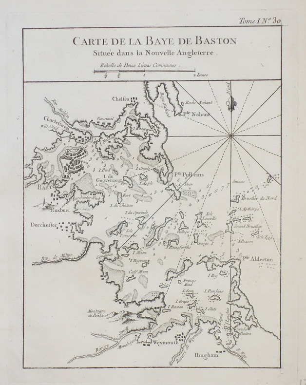
BELLIN (Jacques-Nicolas).
[BOSTON] Carte de la baye de Baston située dans la Nouvelle Angleterre.
1764. 211 x 161 mm.
Bookseller reference : LBW-2386
|
|
|
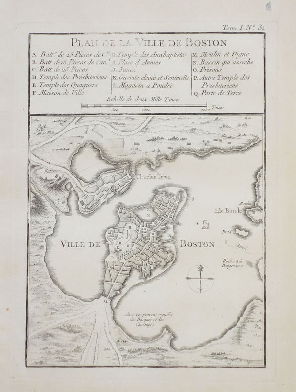
BELLIN (Jacques-Nicolas).
[BOSTON] Plan de la ville de Boston et ses environs.
1764. 212 x 152 mm.
Bookseller reference : LBW-2398
|
|
|
BELLIN (Jacques-Nicolas).
[BRESIL] Plan de la ville de St. Salvador capitale du Brésil.
[circa 1760]. 191 x 300 mm.
Bookseller reference : LBW-2341

|
|
|
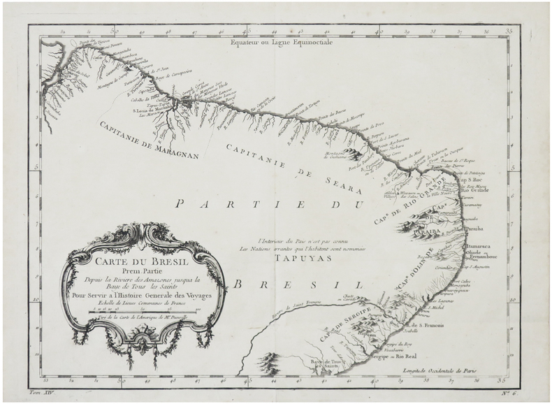
BELLIN (Jacques-Nicolas).
[BRÉSIL] Carte du Brésil, prem. partie. Depuis la rivière des Amazones jusqu'à la Baye de Tous les Saints.
[circa 1750]. 238 x 323 mm.
Bookseller reference : LBW-6382
|
|
|
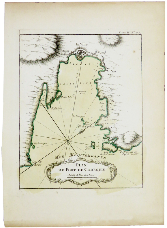
BELLIN (Jacques-Nicolas).
[CADAQUÉS] Plan du port de Cadequie.
[1764]. 220 x 175 mm.
Bookseller reference : LBW-5420
|
|
|
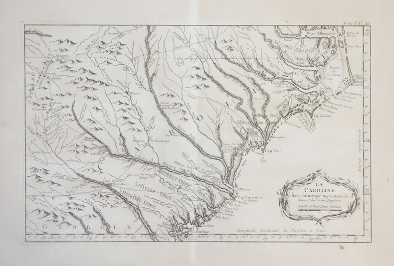
BELLIN (Jacques-Nicolas).
[CAROLINE du NORD et du SUD] La Caroline dans l'Amérique septentrionale suivant les cartes angloises.
1764. 224 x 355 mm.
Bookseller reference : LBW-2394
|
|
|
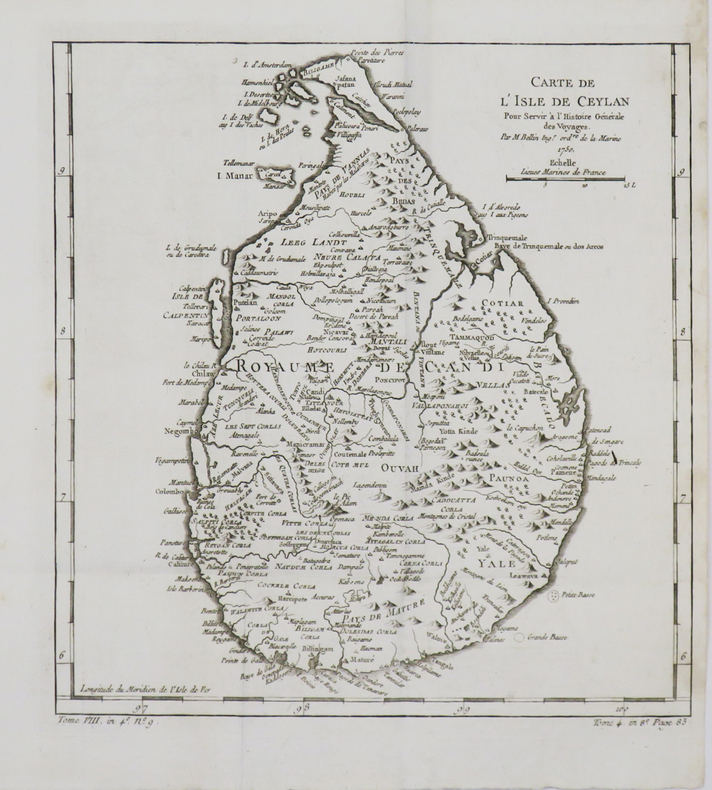
BELLIN (Jacques-Nicolas).
[CEYLAN/SRI LANKA] Carte de l'isle de Ceylan.
1750. 258 x 246 mm.
Bookseller reference : LBW-4786
|
|
 Receive by email
 Download as PDF document
 RSS feed


