|
Benchmark Maps
Wyoming Road & Recreation Atlas - 5th Edition 2022 Benchmark Road & Recreation Atlases
paperback. Good. Access codes and supplements are not guaranteed with used items. May be an ex-library book. paperback
Bookseller reference : 0929591798.G ISBN : 0929591798 9780929591797

|
|
|
Benchmark Maps and Atlases
Wyoming Road & Recreation Atlas Benchmark Recreation Atlases
Benchmark 2018-01-01. 2018. map. New. 10.75x0.50x15.75. Buy with confidence. Excellent Customer Service & Return policy. Benchmark unknown
Bookseller reference : DADAX092959102X ISBN : 092959102X 9780929591025

|
|
|
Benchmark Maps
Wyoming The Cowboy State Recreation Map - 2025 Edition Benchmark
Benchmark Maps 01-12-2024. 2021st ed. map. New. 4.25x0.20x9.00. Buy with confidence. Excellent Customer Service & Return policy. Benchmark Maps unknown
Bookseller reference : DADAX0783499744 ISBN : 0783499744 9780783499741
|
|
|
Benchmark Maps
Wyoming The Cowboy State Recreation Map - 2025 Edition Benchmark
map. Good. Access codes and supplements are not guaranteed with used items. May be an ex-library book. unknown
Bookseller reference : 0783499744.G ISBN : 0783499744 9780783499741
|
|
|
Benchmark Maps
Yosemite National Park California Recreation Map Benchmark
Benchmark Maps 8/15/2021 12:00:01 A. map. Very Good. 0.2362 in x 8.9764 in x 3.8976 in. Benchmark Maps unknown
Bookseller reference : mon0000704396 ISBN : 0783499256 9780783499253
|
|
|
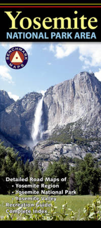
Benchmark Maps
Yosemite National Park Area
Benchmark Maps 2021. Map. New. 2021 edition. 1 pages. 9.40x4.20x0.20 inches. Benchmark Maps unknown
Bookseller reference : 1-0783499256 ISBN : 0783499256 9780783499253
|
|
|
Benchmark Maps
Yosemite National Park California Recreation Map
map. Good. Access codes and supplements are not guaranteed with used items. May be an ex-library book. unknown
Bookseller reference : 0783499256.G ISBN : 0783499256 9780783499253
|
|
|
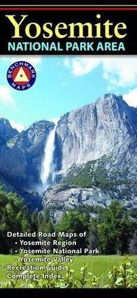
Benchmark Maps and Atlases
Yosemite National Park Area
Natl Geographic Society Maps 2018-02-05. 2016. map. New. 0.00x5.08x7.80. Buy with confidence. Excellent Customer Service & Return policy. Natl Geographic Society Maps unknown
Bookseller reference : DADAX0783498497 ISBN : 0783498497 9780783498492
|
|
|
Benchmark Maps and Atlases
Yosemite National Park Area
map. Good. Access codes and supplements are not guaranteed with used items. May be an ex-library book. unknown
Bookseller reference : 0783498497.G ISBN : 0783498497 9780783498492
|
|
|
Benchmark; National Geographic Maps
New Mexico Road & Recreation Atlas
The new National Geographic Benchmark Recreation Atlases are an ideal recreation resource complete with accurate detailed topographic maps. They contain a wealth of robust travel information including campground locations state park maps sports and activity destinations museums hunting and fishing information historic sites and even climate details. Every feature is clearly labelled field-checked and verified and everything is organised for convenience and intuitive ease-of-use. The books feature a double laminated cover to prevent wear and tear. unknown
Bookseller reference : BIBUP61025-A51284
|
|
|
Benchmark; National Geographic Maps
Utah Road & Recreation Atlas
The new National Geographic Benchmark Recreation Atlases are an ideal recreation resource complete with accurate detailed topographic maps. They contain a wealth of robust travel information including campground locations state park maps sports and activity destinations museums hunting and fishing information historic sites and even climate details. Every feature is clearly labelled field-checked and verified and everything is organised for convenience and intuitive ease-of-use. The books feature a double laminated cover to prevent wear and tear. unknown
Bookseller reference : BIBUP61025-A50465
|
|
|
Bender, Arnold (Intro)
Germany : L'Allemagne : Deutschland
No marks or inscriptions. A very clean very tight copy with bright unmarked hessian boards and no bumping to corners. Dust jacket not price clipped with slightly dusty rear, slight rubbing to edges and small tears to corners and spine ends. 224pp. A book of photographs with an Introduction in English, French and German. Undated, ca 1950s.

|
|
|
Benjamin HANNUNA
Le GUIDE MARABOUT du POKER
Un ouvrage de 192 pages, format 115 x 180 mm, illustré, broché couverture couleurs, publié en 1979, Marabout
Bookseller reference : LFA-126720427
|
|
|
BENJOWSKY Moritz August von; FORSTER Georg (trad.):
Des Grafen Moritz August von Benjowsky Begebenheiten und Reisen. Zweiter Band. Fahrt durch das Stille Meer über Japan und Formosa nach China; und Errichtung einer fransosischen Colonie zu Madagascar.
Leipzig, Dykische Buchhandlung, 1791. Petit in-8 de [6]-602 pages, cartonnage gris, étiquette manuscrite au dos, en grande partie effacée, tranches mouchetées. Premier et dernier cahier déboîtés mais parfaitement solidaires. Quelques rousseurs.
Bookseller reference : 10281

|
|
|
Benn André:
Ex-libris.
Genève, Librairie Jérémiah. Ex-libris au format 13 x 19 cm., à l'état de neuf.
Bookseller reference : 5415

|
|
|
BENNET, Jacques-Henri
La Méditerranée. La rivière de Gênes et Menton comme climats d'hiver et de printemps.
1880 A Paris, Chez Asselin et Cie, Libraires de la Faculté de médecine - 1880 - Fort in-12 (12x18cm environ), pleine percaline rouge, encadrements des plats à froid, titre doré au dos avec décor à froid - Gardes bleues, tranches mouchetées - 432 p. - Avec des gravures in et hors texte, certaines dépliantes - Belles cartes en couleurs dépliantes en début d'ouvrage
Bookseller reference : 109633

|
|
|
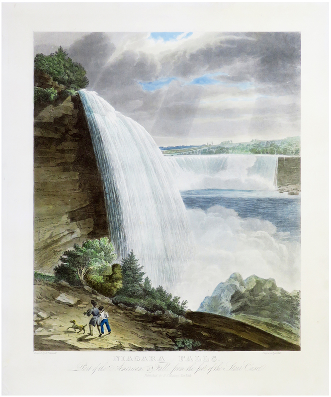
BENNETT (William James).
[CHUTES du NIAGARA] Niagara Falls. Part of the American Fall, from the foot of the Stair Case.
New York, H.I. Megarey, [1829]. 560 x 430 mm.
Bookseller reference : LBW-6825
|
|
|
Bennett, Lindsay
Iceland (Travellers)
Appears unread in mint condition. 192pp. All you need to plan the perfect trip to Iceland and what you can see when you get there.
|
|
|
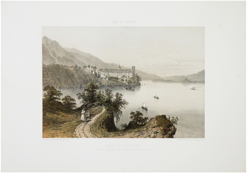
BENOIST (Félix).
[ABBAYE de HAUTECOMBE] Abbaye de Haute-Combe, sur le Lac du Bourget, près d'Aix-les-Bains. (Dép.t de la Savoie).
Nantes, Charpentier, [1864]. 257 x 327 mm.
Bookseller reference : LBW-7184
|
|
|
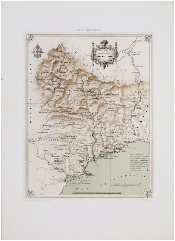
BENOIST (Félix).
[ALPES-MARITIMES] Carte du département des Alpes-Maritimes.
Nantes, Charpentier, [1863]. 350 x 262 mm.
Bookseller reference : LBW-7594
|
|
|
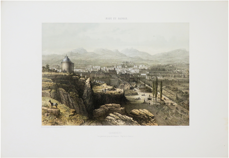
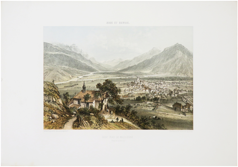
BENOIST (Félix).
[CHAMBÉRY] Chambéry. Vue générale prise de Lémenc. (Dép.t de la Savoie).
Nantes, Charpentier, [1864]. 259 x 313 mm.
Bookseller reference : LBW-7234
|
|
|
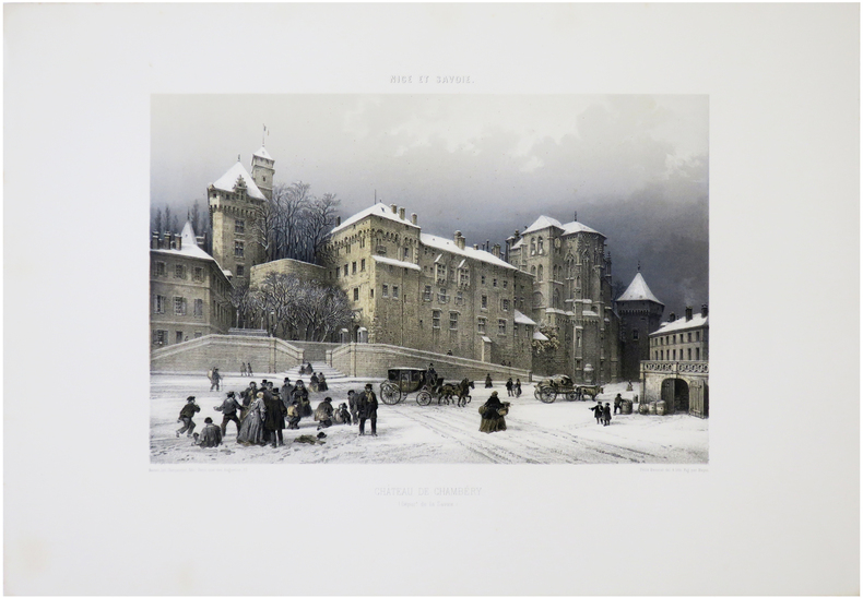
BENOIST (Félix).
[CHAMBÉRY] Château de Chambéry. (Dép.t de la Savoie).
Nantes, Charpentier, [1864]. 248 x 319 mm.
Bookseller reference : LBW-7232
|
|
|
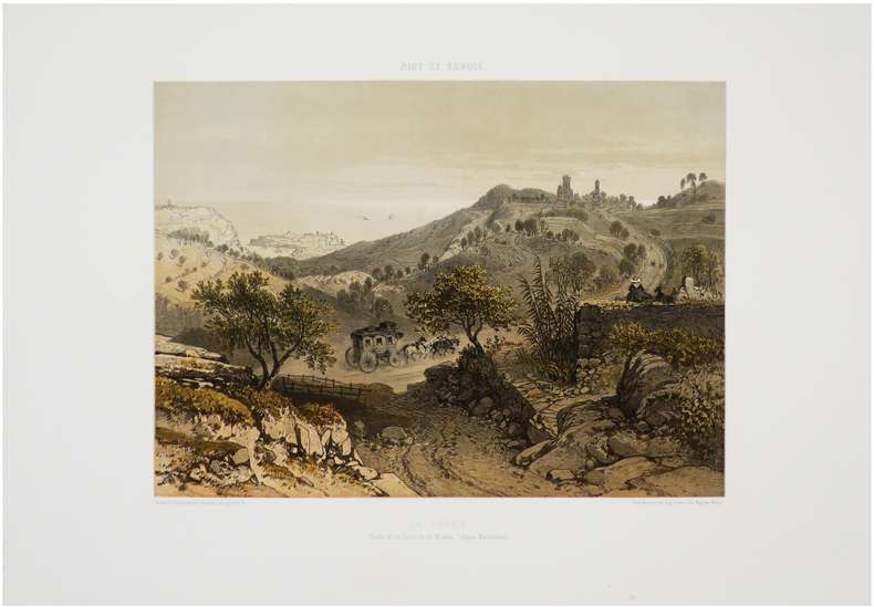
BENOIST (Félix).
[LA TURBIE & MONACO] La Turbie. Route de la Corniche et Monaco. (Alpes-Maritimes).
Nantes, Charpentier, [1863]. 260 x 316 mm.
Bookseller reference : LBW-7536
|
|
|
BENOIST (Félix).
[LES ÉCHELLES] Les Échelles, près Chambéry. (Dép.t de la Savoie).
Nantes, Charpentier, [1864]. 262 x 310 mm.
Bookseller reference : LBW-7175
|
|
|
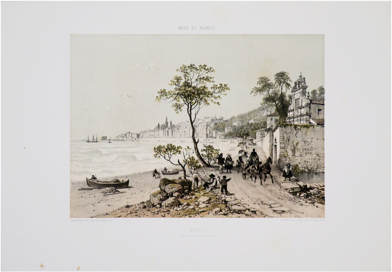
BENOIST (Félix).
[MENTON] Menton (Dép.t des Alpes maritimes).
Nantes, Charpentier, [1863]. 262 x 316 mm.
Bookseller reference : LBW-7555
|
|
|
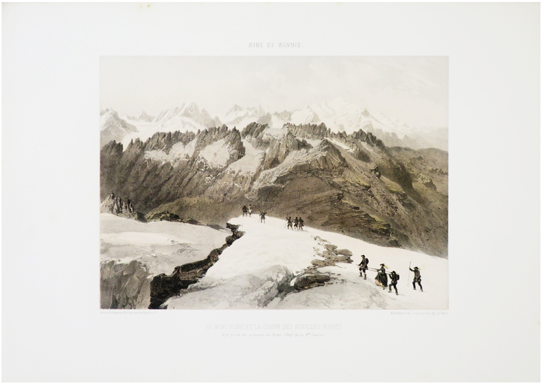
BENOIST (Félix).
[MONT-BLANC] Le Mont Blanc et la chaîne des Aiguilles Rouges. Vue prise du sommet du Buet. (Dép.t de la H.te Savoie).
Nantes, Charpentier, [1864]. 263 x 312 mm.
Bookseller reference : LBW-7182
|
|
|
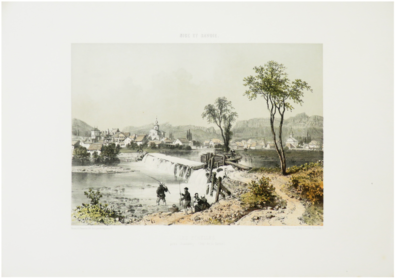
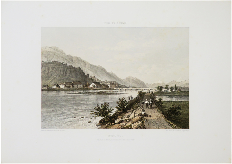
BENOIST (Félix).
[MONTMÉLIAN] Montmélian. Vue prise de la rive gauche de l'Isère. (Dép.t de la Savoie).
Nantes, Charpentier, [1864]. 249 x 312 mm.
Bookseller reference : LBW-7231
|
|
|
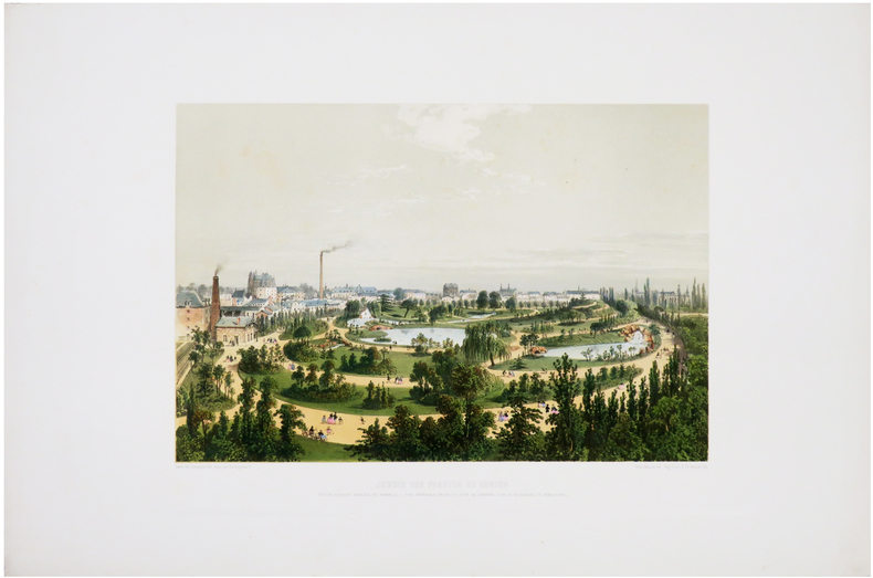
BENOIST (Félix).
[NANTES] Jardin des Plantes de Nantes nouvellement agrandi et embelli. Vue générale prise du côté de l'entrée, sur le boulevard de Sébastopol.
[1860]. 252 x 340 mm.
Bookseller reference : LBW-6518
|
|
|
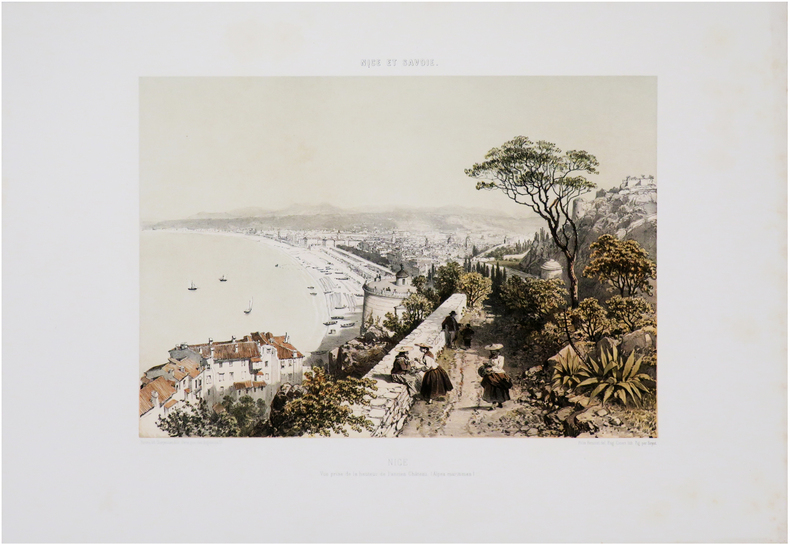
BENOIST (Félix).
[NICE] Nice. Vue prise de l'extrémité du Mont Boron (Dép.t des Alpes maritimes).
Nantes, Charpentier, [1863]. 270 x 321 mm.
Bookseller reference : LBW-7568

|
|
|
BENOIST (Félix).
[NICE] Nice. Vue prise de la hauteur de l'ancien château. (Alpes maritimes).
Nantes, Charpentier, [1863]. 260 x 320 mm.
Bookseller reference : LBW-7587
|
|
|
BENOIST (Félix).
[NICE] Nice. Vue prise de la Villa Venanson (Dép.t des Alpes maritimes).
Nantes, Charpentier, [1863]. 255 x 313 mm.
Bookseller reference : LBW-7592

|
|
|
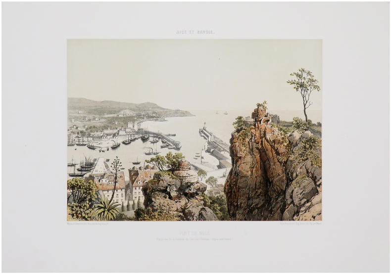
BENOIST (Félix).
[NICE] Port de Nice. Vue prise de la hauteur de l'ancien château. (Alpes maritimes).
Nantes, Charpentier, [1863]. 260 x 316 mm.
Bookseller reference : LBW-7591
|
|
|
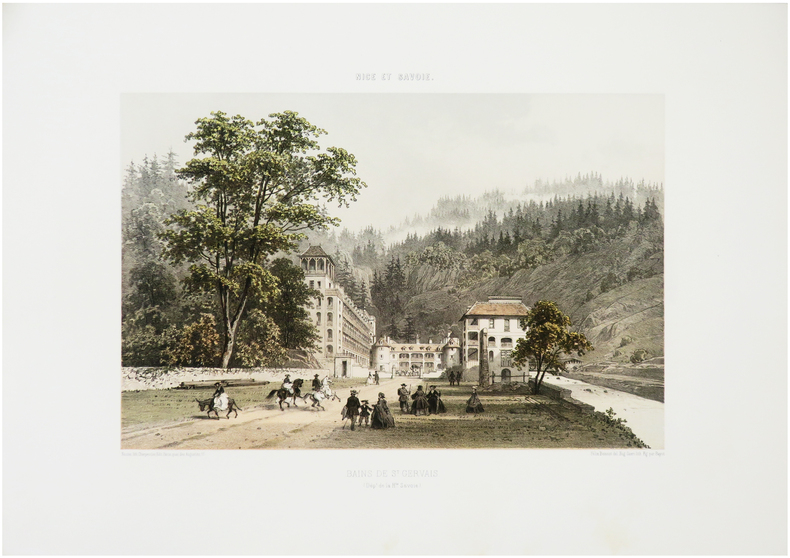
BENOIST (Félix).
[SAINT-GERVAIS-les-BAINS] Bains de S.t Gervais. (Dép.t de la H.te Savoie).
Nantes, Charpentier, [1864]. 255 x 333 mm.
Bookseller reference : LBW-7190
|
|
|
BENOIST (Félix).
[SAINT-JEAN-de-MAURIENNE] Saint Jean-de-Maurienne. (Dép.t de la Savoie).
Nantes, Charpentier, [1864]. 247 x 307 mm.
Bookseller reference : LBW-7230
|
|
|
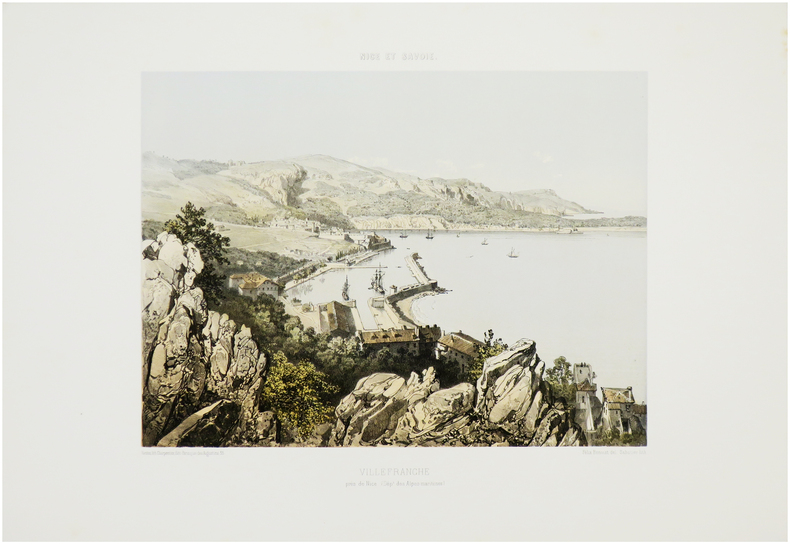
BENOIST (Félix).
[VILLEFRANCHE-sur-MER] Villefranche près de Nice. (Dép.t des Alpes-Maritimes).
Nantes, Charpentier, [1863]. 270 x 315 mm.
Bookseller reference : LBW-7543
|
|
|
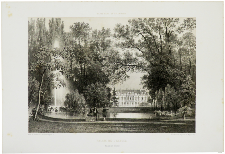
BENOIST (Félix).
Palais de l'Élysée. (Façade sur le parc).
Paris, Henri Charpentier, [1861]. 294 x 366 mm.
Bookseller reference : LBW-5512
|
|
|
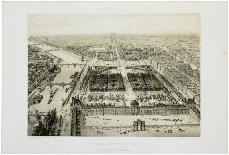
BENOIST (Félix).
Palais et Jardin des Tuileries. Vue à vol d'oiseau, prise au dessus de la Place du Carrousel.
Paris, Henri Charpentier, [1861]. 307 x 373 mm.
Bookseller reference : LBW-5516
|
|
|
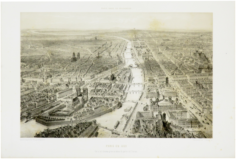
BENOIST (Félix).
Paris en 1860. Vue à vol d'oiseau prise au dessus du quartier de S.t Gervais.
Paris, Henri Charpentier, [1861]. 303 x 399 mm.
Bookseller reference : LBW-5508
|
|
|
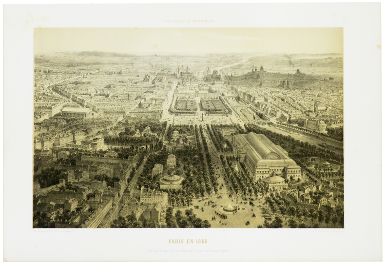
BENOIST (Félix).
Paris en 1860. Vue à vol d'oiseau, prise au dessus du rond-point des Champs-Élysées.
Paris, Henri Charpentier, [1861]. 293 x 400 mm.
Bookseller reference : LBW-5509
|
|
|
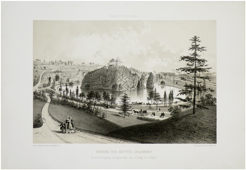
BENOIST (Félix).
Paris et ses ruines. Square des Buttes Chaumont. Vue du lac, des grottes et du grand rocher avec le Temple de Sibylle.
Nantes, Charpentier, [1872]. 287 x 365 mm.
Bookseller reference : LBW-7280
|
|
|
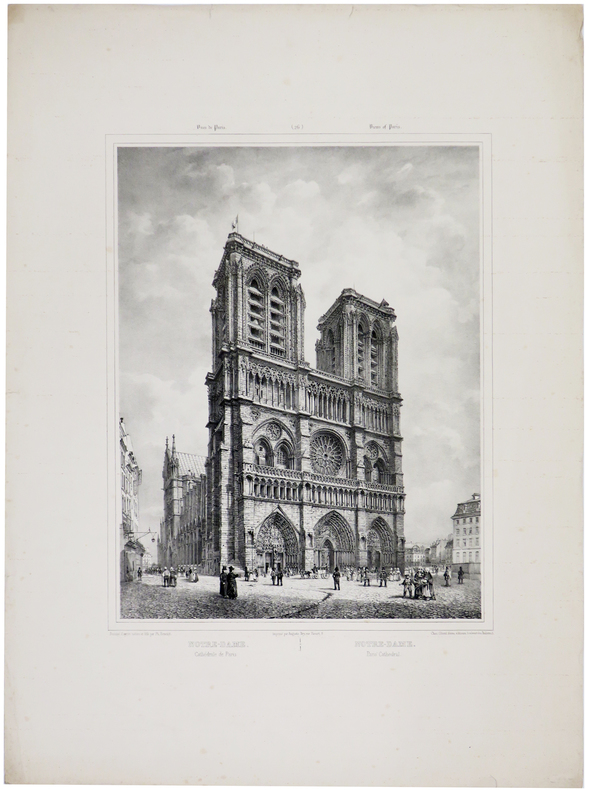
BENOIST (Philippe) & JACOTTET (Louis-Julien).
Notre-Dame. Cathédrale de Paris - Notre-Dame. Paris' Cathedral.
[circa 1840]. 390 x 280 mm.
Bookseller reference : LBW-5673
|
|
|
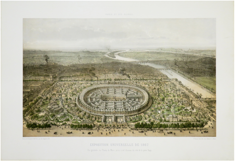
BENOIST (Philippe).
[EXPOSITION UNIVERSELLE] Paris et ses ruines. Exposition universelle de 1867. Vue générale du Champ de Mars, prise à vol d'oiseau du côté de la porte Rapp.
Nantes, Charpentier, [1872]. 287 x 403 mm.
Bookseller reference : LBW-7281
|
|
|
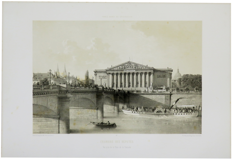
BENOIST (Philippe).
Chambre des Députés. Vue prise de la Place de la Concorde.
Paris, Henri Charpentier, [1861]. 279 x 357 mm.
Bookseller reference : LBW-5515
|
|
|
BENOIST (Philippe).
Les Invalides. Façade principale du côté de l'esplanade.
Paris, Henri Charpentier, [1861]. 290 x 363 mm.
Bookseller reference : LBW-5513

|
|
|
BENOIST (Philippe).
Palais de l'Industrie aux Champs Élysées à Paris.
Paris & Londres, Goupil & C.e & E. Gambart, 1er mai 1855. 390 x 970 mm.
Bookseller reference : LBW-8153

|
|
|
BENOIST (Philippe).
Palais de l'Industrie. Entrée principale.
Paris, Henri Charpentier, [1861]. 278 x 358 mm.
Bookseller reference : LBW-5511

|
|
|
BENOIST Felix (1818 - 1896)
Plan de Rome
Pianta tratta dalla monumentale opera di Felix Benoist Rome dans sa grandeur. Vues, monument ancient et modernes stampata a Parigi in 3 volumi, da Henri Charpentier, nel 1870. La pubblicazione, illustrata da 100 litografie, fu preceduta da una campagna di disegni preparatori, a far data dal 1864 sino al 1869, eseguita soprattutto da Félix Benoist e in parte da Philippe Benoist. Alla vigilia del Concilio Ecumenico Vaticano I, l’11 agosto 1869, Pio IX decretava la realizzazione di una Esposizione romana delle opere d’ogni arte eseguite per il culto cattolico, che venne inaugurata, il 17 febbraio 1870, nel chiostro della Certosa di Santa Maria degli Angeli. In quell’occasione, vennero presentati i tre volumi in folio Rome dans sa grandeur. I volumi, rilegati in modo sfarzoso, con impresso al centro in oro, lo stemma di Pio IX, sono suddivisi in tre sezioni. Il primo volume tratta di Roma antica, il secondo, di Roma cristiana, ed il terzo, dei monumenti e le realizzazioni della Roma moderna. Una visione preziosa della Roma papale alla vigilia della profonda trasformazione di Roma in capitale dell’Italia unita. Un documento che evidenzia la notevole impronta lasciata da Pio IX nella Città Eterna. L’opera rappresenta il capolavoro dell’artista francese, dove ogni veduta è realizzata in litografia tinta, processo ottenuto usando un diverso numero di pietre. Il risultato è un’opera di grande effetto, tanto da porre il Benoist tra la schiera dei più grandi artisti di interni e vedute del suo tempo. Litografia tinta, finemente colorata a mano, in ottimo stato di conservazione. Map taken from the monumental work of Felix Benoist Rome dans sa grandeur. Vues, monument ancient et modernes printed in Paris in 3 volumes, by Henri Charpentier, in 1870. The publication, illustrated by 100 lithographs, was preceded by a campaign of preparatory drawings, from 1864 to 1869, executed mainly by Felix Benoist and partly by Philippe Benoist. On the eve of the First Vatican Ecumenical Council, August 11, 1869, Pius IX decreed the creation of the Esposizione romana delle opere d’ogni arte eseguite per il culto cattolico (a Roman Exhibition of the works of art created for Catholic worship), which was inaugurated on February 17, 1870, in the cloister of the Charterhouse of Santa Maria degli Angeli. On that occasion, the three volumes in folio Rome dans sa grandeur were presented. The volumes, magnificently bound, with the coat of arms of Pius IX stamped in gold in the center, are divided into three sections. The first volume deals with ancient Rome, the second with “Christian” Rome, and the third with the monuments and achievements of modern Rome. A precious vision of papal Rome on the eve of the profound transformation of Rome into the capital of united Italy. A document that highlights the remarkable imprint left by Pius IX in the Eternal City. The work represents the masterpiece of the French artist, where each view is made in tinted lithography, a process achieved by using a different number of stones. The result is a work of great effect, so much so as to place Benoist among the ranks of the greatest artists of interiors and views of his time. Tinted lithograph, finely hand-colored, in excellent condition.

|
|
|
Benoît Van Innis:
Après le dîner Monsieur de Kerckhuve leur offrit un préservatif.
Carouge, Fondation du présent et les auteurs, 1991. Lot de 80 x la même grande carte (16x22), éditée à l’occasion de l’album collectif "Les aventures du latex", projet réunissant des auteurs européens autour du thème de la prévention et du préservatif. Illustration de Benoît Van Innis.
Bookseller reference : 26434

|
|
|
Bensard Eva Fransoua
Ma petite histoire de la Bretagne
PLACE VICTOIRES 2026 64 pages 24 8x26 4x1 4cm. 2026. Relié. 64 pages.
Bookseller reference : 500137438

|
|
|
Bentata Azaz, Victoria A-Z Maps
-Z Oxford Hidden Walks: Discover 20 Routes In And Around The City
Harpercollins Publishers 2022. Paperback / Softback. New. 128 pages. 7.05x4.96x0.55 inches. Harpercollins Publishers paperback
Bookseller reference : __0008496323 ISBN : 0008496323 9780008496326

|
|
 Receive by email
 Download as PDF document
 RSS feed


