|
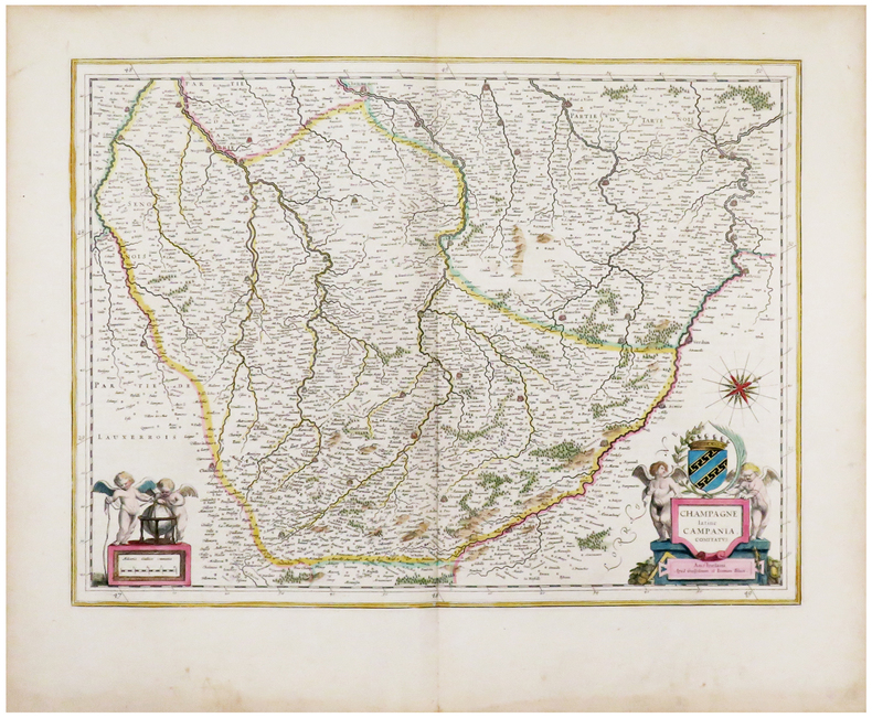
BLAEU (Johannes) & BLAEU (Willem).
[CHAMPAGNE] Champagne latine Campania, comitatus.
Amsterdam, [1643-1650]. 379 x 497 mm.
Bookseller reference : LBW-6197
|
|
|
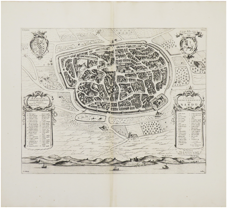
BLAEU (Johannes) & MORTIER (Pierre).
[NARDO] Civitas Neritonensis, vulgo Nardo - Nardo ville du Royaume de Naples située dans la terre d'Otranto.
[Amsterdam, Pierre Mortier, 1704-1705]. 413 x 523 mm.
Bookseller reference : LBW03593
|
|
|
BLAEU (Johannes).
[AUVERGNE] Auvergne.
[Amsterdam, 1668]. 433 x 540 mm.
Bookseller reference : LBW-8686

|
|
|
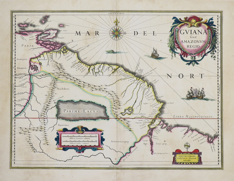
BLAEU (Johannes).
[GUYANE] Guiana sive Amazonum regio.
[Amsterdam, 1635-1638]. 373 x 494 mm.
Bookseller reference : LBW-4801
|
|
|
BLAEU (Johannes).
[LEÓN & ASTURIES] Legionis regnum et Asturiarum principatus.
[Amsterdam, 1647-1669]. 382 x 502 mm.
Bookseller reference : LBW-8804

|
|
|
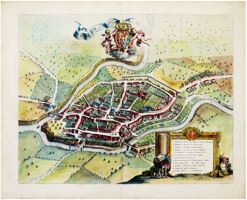
BLAEU (Johannes).
[SAVOIE/RUMILLY] Rumiliacum vulgo Rumilly.
[Amsterdam, 1682]. 457 x 575 mm.
Bookseller reference : LBW-6784
|
|
|
BLAEU (Johannes).
[SUÈDE] Stellæburgum sive observatorium subterraneum, a Tychone Brahe nobili Dano in insula Huæna, extra Arcem Uraniam, extructum circa annum MDLXXXIII.
Amsterdam, [1663]. 433 x 540 mm.
Bookseller reference : LBW-8208

|
|
|
BLAEU (Johannes).
Gouvernement général du Lyonnois.
Amsterdam, [circa 1660]. 410 x 572 mm.
Bookseller reference : LBW-422
|
|
|
BLAEU (Johannes);
[BRESIL] Nova et accurata Brasiliae totius tabula.
Amsterdam Petrus Schenk circa 1680 497 x 588 mm.
Bookseller reference : LBW04170

|
|
|
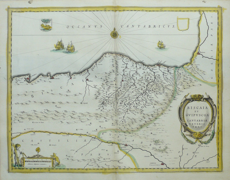
BLAEU (Johannes);
[PAYS BASQUE] Biscaia et Guipuscoa Cantabriae veteris pars.
Amsterdam vers 1640 380 x 497 mm.
Bookseller reference : LBW02501
|
|
|
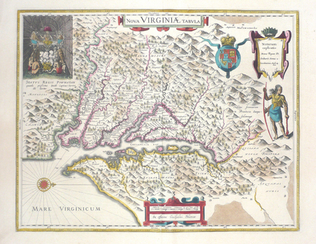
BLAEU (Johannes);
[VIRGINIE] Nova Virginiae tabula.
Amsterdam 1643-1650 376 x 481 mm.
Bookseller reference : LBW03574
|
|
|
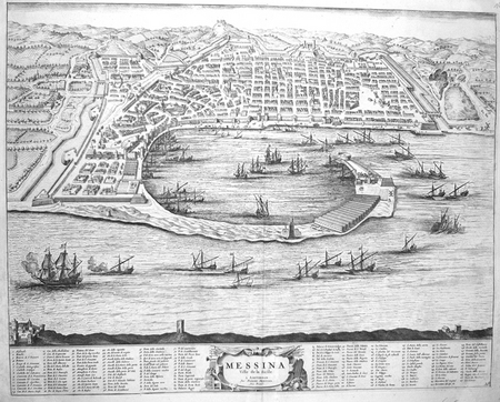
BLAEU (Johannes);MORTIER (Pierre);
[MESSINE] Messina ville de la Sicile.
Amsterdam Pierre Mortier 1704 414 x 522 mm.
Bookseller reference : LBW00282
|
|
|
BLAEU (Johannes);MORTIER (Pierre);
[MILAZZO] Melazzo ou Milazzo, ville de la vallée de Demona, en Sicile.
Amsterdam Pierre Mortier 1704-1705 410 x 541 mm.
Bookseller reference : LBW03599
|
|
|
BLAEU (Johannes);MORTIER (Pierre);
[NOCERRA/CASTELNOVO] Nocerra ville de l'Etat de l'Eglise, dans le duché de Spoleto - Castel Novo. Entre Lorete & Rome.
Amsterdam Pierre Mortier 1704-1705 408 x 514 mm.
Bookseller reference : LBW0359a
|
|
|
BLAEU (Johannes);MORTIER (Pierre);
[POUZZOLES] Puteolanus ager. Le golfe de Pouzol et une partie du golfe de Naples elle est vers la ville de Pouzol, & les ruines des Baies.
Amsterdam Pierre Mortier 1704 406 x 510 mm.
Bookseller reference : LBW00281

|
|
|
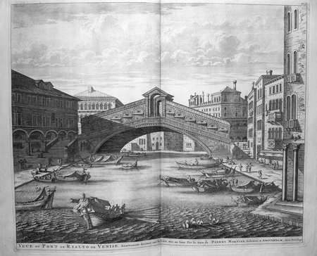
BLAEU (Johannes);MORTIER (Pierre);
[VENISE] Veue du pont de Rialto de Venise.
Amsterdam Pierre Mortier 1704 442 x 534 mm.
Bookseller reference : LBW00271
|
|
|
BLAEU (Johannes);MORTIER (Pierre);
[VOLTERRA] Nova Vulterrae delineatio. Volterre ancienne ville de Toscane, suffragante de Florence, située dans le Pisan.
Amsterdam Pierre Mortier 1704-1705 403 x 558 mm.
Bookseller reference : LBW03598

|
|
|
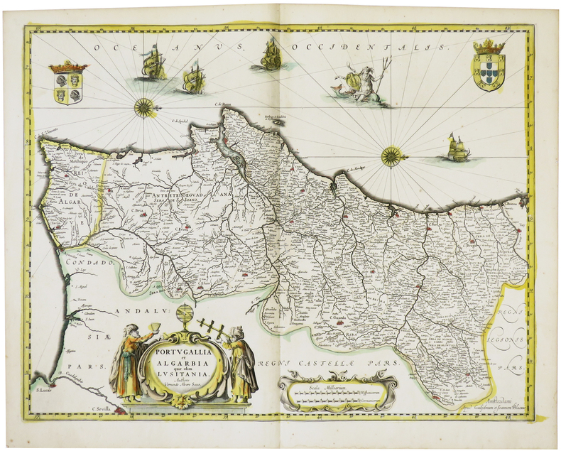
BLAEU (Willem & Johannes).
[PORTUGAL] Portugallia et Algarbia quae olim Lusitania.
Amsterdam, [circa 1640]. 382 x 498 mm.
Bookseller reference : LBW-1469
|
|
|
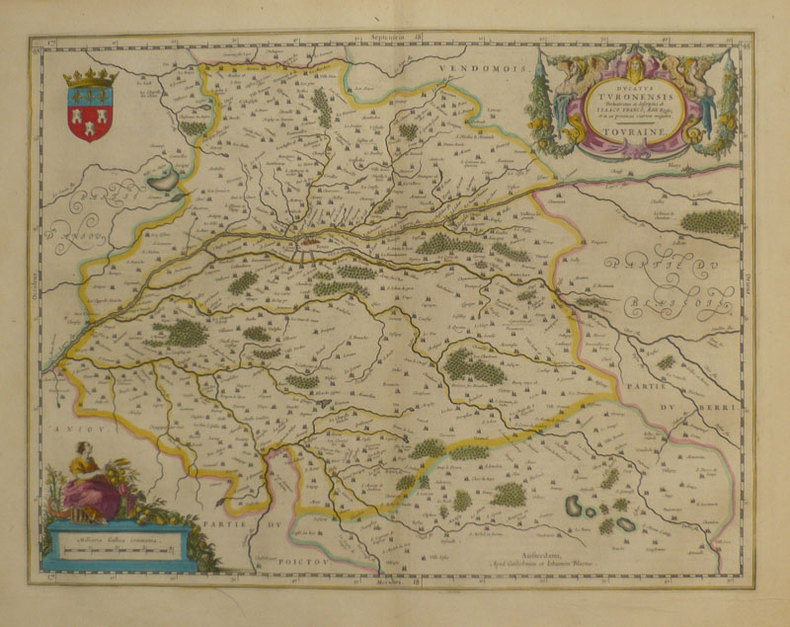
BLAEU (Willem & Johannes);
Ducatus Turonensis - Touraine.
Amsterdam 1661 380 x 497 mm.
Bookseller reference : LBW-862
|
|
|
BLAEU (Willem & Johannes);
Picardia regio Belgica.
Amsterdam 1661 379 x 532 mm.
Bookseller reference : LBW-859

|
|
|
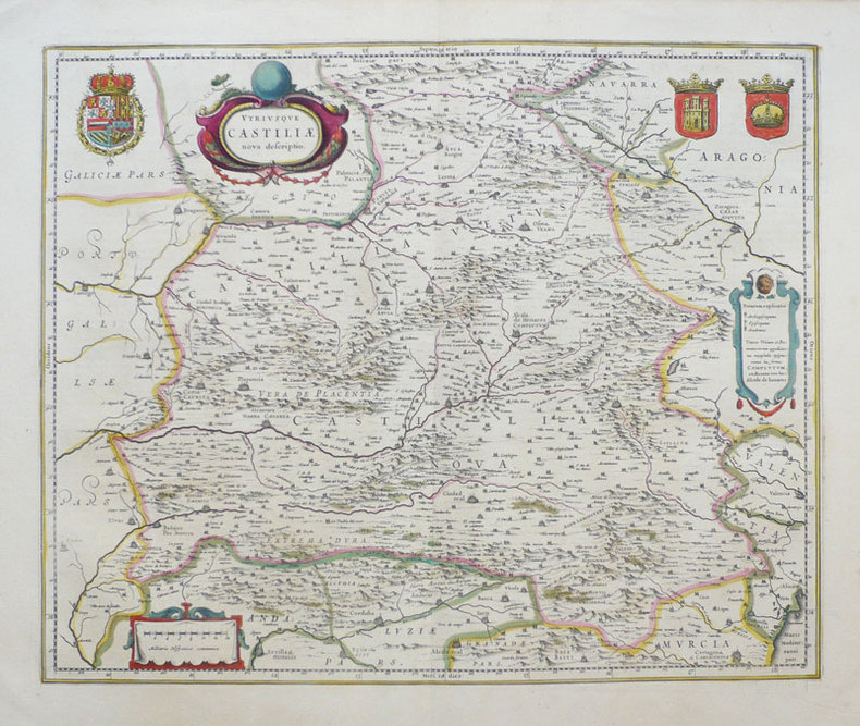
BLAEU (Willem & Johannes);
Utriusque Castiliae nova descriptio.
Amsterdam 1638-1640 411 x 501 mm.
Bookseller reference : LBW-949
|
|
|
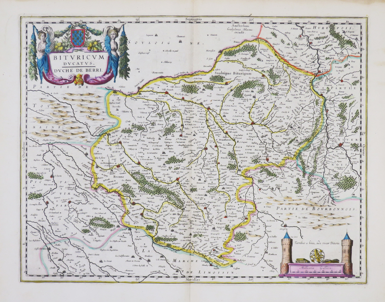
BLAEU (Willem).
[BERRY] Bituricum ducatus - Duché de Berri.
Amsterdam, [1643-1650]. 380 x 498 mm.
Bookseller reference : LBW-861
|
|
|
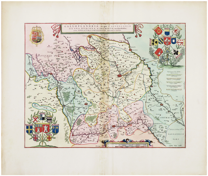
BLAEU (Willem).
[FLANDRE] Galloflandria, in qua Castellaniæ Lilana, Duacena, & Orchiesia, cum dependentibus ; nec non Tornacum, & Tornacesium.
[Amsterdam, 1662]. 374 x 486 mm.
Bookseller reference : LBW-6308
|
|
|
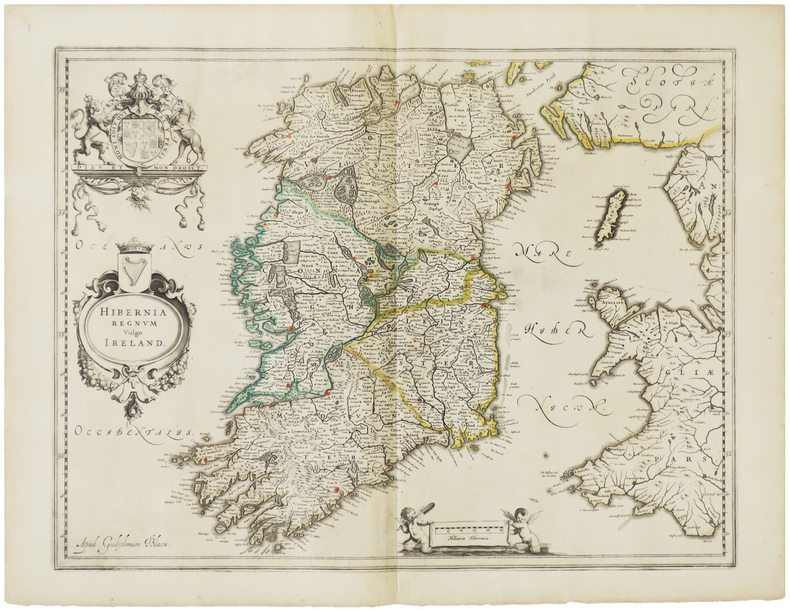
BLAEU (Willem).
[IRLANDE] Hibernia regnum vulgo Ireland.
[Amsterdam, vers 1640]. 384 x 497 mm.
Bookseller reference : LBW-1474
|
|
|
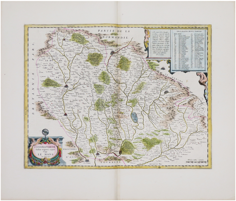
BLAEU (Willem).
[MAINE] Cenomanorum Galliæ regionis typus vulgo Le Mans.
[Amsterdam, 1642-1650]. 382 x 500 mm.
Bookseller reference : LBW-8049
|
|
|
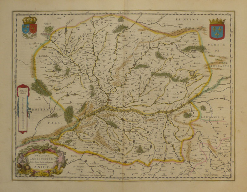
BLAEU (Willem);
Ducatus Andegavensis - Anjou.
Amsterdam 1661 381 x 497 mm.
Bookseller reference : LBW-863
|
|
|
Blaeu, Guiljelmum [Willem Janszoon]; Blaeu, Ioannem [Joan]
Brandeburgum Marchionatus. cum Ducatibus Pomeraniae et Mekelenburgi. 1635. [Altkolorierter Kupferstich, gerahmt / handcoloured copper engraving, framed].
o.J. [3 Warenabbildungen] (Guiljelmum Blaeu, dt. Willem Janszoon Blaeu, geb. 1571 in Alkmaar oder Uitgeest, gest. 1638, niederländischer Kartograf
Bookseller reference : 66144CB

|
|
|
Blaeu, Johan [Joan Blaeuw]
Iutia olim Cimbrica Chersonesus [Jütland, einst Cimbrica Chersonesus]. Kolorierte Kupferstichkarte mit 2 figürlichen Kartuschen.
[Amsterdam, Johannes Blaeu, [ca. 1667]. Darstellung ca. 43,5 x 57,5 cm., Blatt ca. 52 x 61 cm.
Bookseller reference : 79684

|
|
|
Blaeu, Johannes; [Joan Bleau]
Calabria Citra olim Magna Graecia. [Altkolorierter Kupferstich / colored copper engraving].
o.J. Joan Blaeu (Johannes Blaeu), geboren 1596 in Alkmaar, Niederlande; gestorben 1673 in Amsterdam.
Bookseller reference : 53247BB

|
|
|
Blaeu, Willem
Stiria. Steyrmarck. Zeitgenössisch grenzkolorierte Kupferstichkarte.
Amsterdam, W. Blaeu um 1639. Bildausschnitt: 50x37,5 cm, Blattgröße: 49,7 x 59 cm; mittiger, gebräunter Falz, oben rechts dekorative Wappenkartusche, auf Rückseite lateinische Legende mit attraktiver Anfangsinitiale. Attraktives Blatt.
Bookseller reference : KART0160

|
|
|
Blaeu, Willem Janszoon
Circulus Westphalicus sive Germaniae inferioris. [Altkolorierter Original-Kupferstich / original colored copper engraving].
o.J. Willem Janszoon Blaeu, (auch: Guiljelmus Blaeuw, Willem Jansz, Willems Jans Zoon, Guilielmus oder G. Blaeu), geboren 1571 in Alkmaar oder Uitgeest, gestorben 1638 in Amsterdam. Niederländischer Kartograf und Verleger. [2 Warenabbildungen]
Bookseller reference : 12065DB

|
|
|
Blaeu, Willem Janszoon
Ducatus Luneburgensis adiacentiumque regionum delineatio. 1635. [Altkolorierter Kupferstich, gerahmt].
o.J. (Willem Janszoon Blaeu, geb. 1571 in Alkmaar oder Uitgeest (NL), gest. 21.10.1638 in Amsterdam, niederländischer Kartogr
Bookseller reference : 66533CB
|
|
|
Blaeu, Willem Janszoon
Saxonia Superior, & Hall Episcopatus. 1662. [Altkolorierter Kupferstich, gerahmt].
o.J. (Willem Janszoon Blaeu, geb. 1571 in Alkmaar oder Uitgeest (NL), gest. 21.10.1638 in Amsterdam, niederländischer Kartogr
Bookseller reference : 66534CB
|
|
|
Blaeu, Willem Janszoon:
"Territorium Norimbergense". Kupferstich mit zwei zeitgenössisch kolorierten dekorativen Kartuschen und rechts unten mit einer Gesamtansicht von Nürnberg aus der Vogelschau sowie mit zeitgenössischenm Grenz- und Landschaftskolorit.
36,5 x 47 cm. Blattgröße: 50 x 61 cm. *Rückseitig ohne Text. Breitrandiges sehr gut erhaltenes Exemplar, lediglich am Unterrand leicht fingerfleckig. Landkarten de
|
|
|
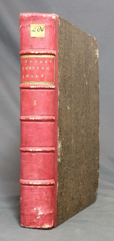
BLAINVILLE:
Travels Through Holland, Germany, Switzerland, and Other Parts of Europe, But Especially Italy. Vol. I.
London, printed by W. Strahan for John Noon and R. Dodsley, 1743. In-4 de [6]-XII-[16-index]; de 49 à 564-XII (the contents)-[2] pages, demi-basane vieux rose, coins de veau brun, dos à 5 nerfs avec titre et encadrement dorés, tranches marbrées.
Bookseller reference : 12672
|
|
|
Blair, John L. (editor)
The Lake District
No marks or inscriptions. A very clean very tight copy with bright unmarked boards and no bumping to corners. Dust jacket not price clipped with dusty rear, piece missing around spine foot and a few small tears. 124pp. A guide to England's Lake District. Undated ca 1958.

|
|
|
Blake, Don
Blakeburn - From Dust to Dust: The Rise and Fall of a Coal Mining Town
(iv), 164 pages. Bibliography. Tables. Many black and white reproductions of archival black and white photos. Two fold-out maps. Author discovered the remains of Blakeburn while on vacation and, after finding a dearth of relevant history, decided to write a history of the town, located northwest of Princeton, B.C. First fold-out map shows the major buildings in Blakeburn and the underground workings of her three major mines in 1935. Second map shows No. 4 mine after the August 13, 1930 explosion. (Hale & Barman 84) Book

|
|
|
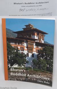
Blake, Laura; text, photos, maps and drawings
Bhutan's Buddhist Architecture - Written and Published by Laura Blake
San Francisco: Self-published by the author 2015. Paperback. 108p. illustrated expertly by the architect author; her two line maps the numerous floorplan plats and the photographs in color very clear show an amazing combination of talents. Softbound in 10x8 inch colorphoto wraps an as-new copy despite Blake's brief ballpoint gift inscription on copyright page signed as "Laura" that is entirely sound clean and otherwise unmarked. Blake a practicing architect who is or was based in San Francisco. Conveniently the city boasts a full-on Asian Art Museum and consultation was provided by assistant curator Jeff Durham. Self-published by the author paperback
Bookseller reference : 328252 ISBN : 0996663908 9780996663908
|
|
|
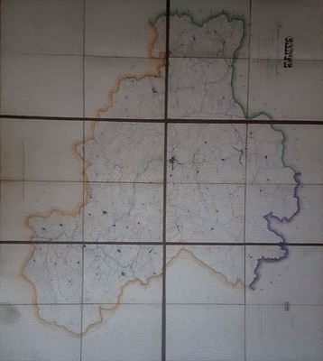
BLANC - DUVIOL
Carte routière et vicinale de l'arrondissement de Lodève dressée sous l'administration de Monsieur Balland, Préfet de l'Hérault, de Monsieur Alazard sous Préfet par Blanc, Agent Voyer ordinaire et Duviol, Agent Voyer conducteur, dessinateur
Vers 1850. Superbe carte monumentale entoilée manuscrite, encre et aquarelle, de 6 feuilles mesurant en totalité 1, 20 mêtre sur 1,32 mètre. Chaque feuille de 60 x 44 cm. L'ensemble replié dans un étui cartonné, titre sur une vignette contrecollée. Echelle de 23 dix millième de mètres pour 100 mètres. On notera une grande précision dans le dessin quant aux chemins vicinaux, à l'habitat, aux noms des Hameaux, Mas, Lieux dits, Riviéres ou Ruisseaux, Moulins ou Usines, Auberges, Relais de Poste, Eglises, Ponts, Ruines, Bergeries avec noms des propriétaires etc. Etui un peu frotté, vignette contrecollée tachée. Très bel état de la carte.

|
|
|
BLANC - DUVIOL
Carte routière et vicinale de l'arrondissement de Lodève dressée sous l'administration de Monsieur Balland, Préfet de l'Hérault, de Monsieur Alazard sous Préfet par Blanc, Agent Voyer ordinaire et Duviol, Agent Voyer conducteur, dessinateur
Sans lieu Vers 1850. Superbe carte monumentale entoilée manuscrite, encre et aquarelle, de 6 feuilles mesurant en totalité 1, 20 mêtre sur 1,32 mètre. Chaque feuille de 60 x 44 cm. L'ensemble replié dans un étui cartonné, titre sur une vignette contrecollée. Echelle de 23 dix millième de mètres pour 100 mètres. On notera une grande précision dans le dessin quant aux chemins vicinaux, à l'habitat, aux noms des Hameaux, Mas, Lieux dits, Riviéres ou Ruisseaux, Moulins ou Usines, Auberges, Relais de Poste, Eglises, Ponts, Ruines, Bergeries avec noms des propriétaires etc. Etui un peu frotté, vignette contrecollée tachée. Très bel état de la carte.
Bookseller reference : 131674
|
|
|
Blandford, Percy W.
Maps & Compasses : A User's Handbook
243 pages including index and glossary. Normal library markings. Abover average wear to boards with portion of front board peeled off at lower left corner. Corner of title page clipped off. Learn to read all there is to be found on a map. Learn to use the map with a compass. Learn to make simple maps and plans. These are worthwhile accomplishments. They are what this book is all about. Complete with many black and white diagrams and occasional photographs. A very practical book. Book
|
|
|
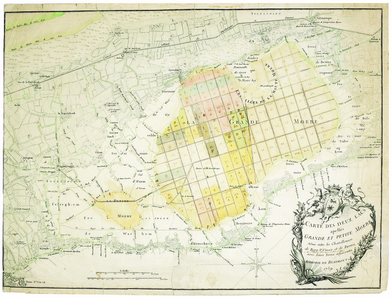
BLANMONT (Alphonse). MANUSCRIT.
Carte des deux lacs apellés Grande et Petite Moëre, situés entre les chatellenies de Berg S.t Vinox, et de Furnes avec leurs terres adjacentes.
1759. 480 x 635 mm.
Bookseller reference : LBW-4098
|
|
|
BLASI Alfredo
Roma (Veduta dal Gianicolo)
Veduta panoramica della città dal Gianicolo. Pubblicazione fatta a cura del Consiglio Centrale per l'Italia dalla Pontificia Opera della Propagazione della Fede.In basso una legenda di 46 richiami sui luoghi notabili della città.Xilografia a colori, di Alfredo Blasi, la cui firma è in basso a destra.Rara. Veduta panoramica della città dal Gianicolo. Pubblicazione fatta a cura del Consiglio Centrale per l'Italia dalla Pontificia Opera della Propagazione della Fede.In basso una legenda di 46 richiami sui luoghi notabili della città.Xilografia a colori, di Alfredo Blasi, la cui firma è in basso a destra.Rara.

|
|
|
BLASSELLE Ren? - BONNET Marc - SERRYN Pierre
Les atlas.Tome second : -1 Atlas g?ographique -2 Atlas historique.
Reli?. 168 + 79 pages. 21 x 30 cm.
|
|
|
Bliven, Bruce, Jr.; Maps and Photos [Illustrator]
From Pearl Harbor To Okinawa
Random House 1960-01-01. Hardcover. Good/Acceptable. 8x5x1. Hardbound with dust jacket. Book with limited gentle wear; pages unmarked. Jacket with general wear and tear. Random House hardcover
Bookseller reference : 72502
|
|
|
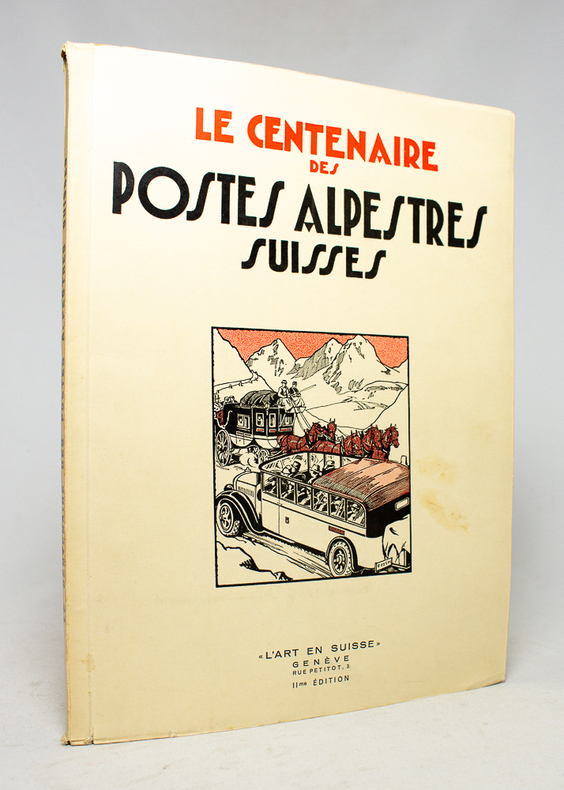
BLOESCH H.; BUDRY Paul; CHAPONNIERE Paul; GRELLET Pierre; HENRIOUD Marc:
Le centenaire des postes alpestres suisses.
Genève, L'Art en Suisse, 1932. In-4 broché de 80 pages, couverture à rabats illustrée en deux tons.
Bookseller reference : 17496
|
|
|
BLOND, Georges - CARMIGNIANI, Juan Carlos - Préfacé par le Général Beaufre - Aquarelles du Baron Louis de Beaufort - Cartes de Jean-Claude Quennevat
1914, la Marne
1974 Editions Stock, Presses de la Cité - Collection "Les Grandes Batailles" - 1974 - In-4, cartonnage toilé rouge sous jaquette illustrée en couleurs de l'éditeur - 232 p. - Très riche iconographie in, hors-texte et pleine page en couleurs et en N&B
Bookseller reference : 108220
|
|
|
BLONDEAU.
Etats Unis de l'Amérique.
[circa 1795]. 180 x 203 mm.
Bookseller reference : LBW024c8

|
|
|
BLONDEL LA ROUGERY
CARTE DE LA LOIRE-INFERIEURE
1950 carte dépliante in-octavo dans une chemise illustrée en bleu et rouge, format déplié : 72,5 centimètres de large par 54,5 centimètres de haut, sans date (1930 environ) Paris Blondel La Rougery Editeur,
Bookseller reference : 8336
|
|
|
BLONDEL LA ROUGERY (Max).
Carte des lignes. Compagnie Générale Transatlantique. French line.
Paris, Blondel La Rougery, 1959. 750 x 980 mm.
Bookseller reference : LBW-6644

|
|
 Receive by email
 Download as PDF document
 RSS feed


