|
Goebel, Michael/ 3 Maps (Corporate Author)/ Print
Overlapping Geographies of Belonging: Migrations Regions and Nations in the Western South Atlantic
like new. unknown
Bookseller reference : 26747188 ISBN : 0872292053 9780872292055
|
|
|
Goebel, Michael/ 3 Maps (Corporate Author)/ Print
Overlapping Geographies of Belonging: Migrations Regions and Nations in the Western South Atlantic
new. unknown
Bookseller reference : 26747188-n ISBN : 0872292053 9780872292055
|
|
|
Goebel, Michael/ 3 Maps (Corporate Author)/ Print
Overlapping Geographies of Belonging: Migrations Regions and Nations in the Western South Atlantic
Amer Historical Assn 2013. Paperback. New. 60 pages. 5.30x8.20x0.40 inches. Amer Historical Assn paperback
Bookseller reference : x-0872292053 ISBN : 0872292053 9780872292055
|
|
|
GOGEARD (Clément).
[ROUEN] Plan de la ville de Rouen.
1889. En 36 sections montées sur toile et repliées, formant un plan de 1,18 x 1,94 m ; étiquette au dos de l'éditeur parisien Lanée, successeur de Longuet ; sous chemise et étui de papier marbré de l'époque, avec pièce de titre rouge au dos.
Bookseller reference : LBW-8076

|
|
|
GOGUE A.
La cuisine Française
in 12 demi-chagrin ver à nerfs titre fers dorés filets à froid faux-titre,titre,VIII,536 pages,45 gravures sur bois dans le texte par ROUYER Hachette & Cie 1869 Bon exemplaire
Bookseller reference : 2676
|
|
|
GOLAY, Laurent / Cosinschi-Meunier, Micheline / HEFTI, Jocelyne:
Images du monde : une histoire de la cartographie.
Lausanne : Musée historique de Lausanne, 2004, in-4to oblong, 111 p., ill., brochure originale illustrée.
Bookseller reference : 135094aaf
|
|
|
Goldberg Rube:
Inventions! 30 Rube Goldberg Postcards.
Stewart, Tabori & Chang, 1996. 30 cartes postales d'inventions loufoques et hilarantes par Rube Goldberg. Trace d'étiquette de prix au second plat, pour le reste à l'état de neuf.
Bookseller reference : 1278

|
|
|
Goldeneye Maps Firm
Cotswolds & Forest of Dean pictorial guide of places to visit & tourist map: 2 miles to 1 inch : the all-purpose map-guide descriptions and . : double sided Goldeneye map-guide series
Goldeneye Maps. Used - Acceptable. Acceptable condition. Map is torn but taped. Maps travel guide England Goldeneye Maps unknown
Bookseller reference : SB12D-02033 ISBN : 0946077886 9780946077885
|
|
|
GOLDENEYE Maps
COTSWOLDS & FOREST of DEAN - PICTORIAL GUIDE of PLACES to VISIT and TOURIST MAP; £ 2.50. Scale 2 Miles To 1 Inch
: GOLDENEYE Maps 1989. Soft cover. Near Fine. Map: Near Fine/ $35.14 0946077614 COTSWOLDS & FOREST of DEAN - PICTORIAL GUIDE of PLACES to VISIT and TOURIST MAP; £ 2.50. GOLDENEYE Maps GOLDENEYE Maps 1989 UnStated Edition Tall S/c Folding Map: Near Fine/ Slight Or No Use. Scale 2 Miles To 1 Inch. D/j: None; Case: None. No Odors No Writing No Names No Stains. Description Applies To This Map ONLY. This Map Is Hard To Find Will Be Packaged And Shipped Carefully To Avoid Shipping Damage And Will Make It An Excellent Addition To Your Own Personal Library Collection Or As A Gift. WORLD WIDE SHIPPING AVAILABLE. <br/> <br/> GOLDENEYE Maps paperback
Bookseller reference : 013297 ISBN : 0946077614 9780946077618
|
|
|
Goldsborough, Gordon
More Abandoned Manitoba: Rivers, Rails and Ruins
Book is in excellent condition. Binding is solid and square, covers have sharp corners, exterior shows no blemishes, text/interior is clean and free of marking of any kind. 280 pages, loaded with color & b&w photos, maps, charts, tables.
|
|
|
GOLTZ Baron Colmar von der; CHABERT (trad.):
Rosbach & Iéna. Recherches sur l'état physique et intellectuel de l'Armée Prussienne pendant l'époque de transition du XVIIIe au XIXe siècle.
Paris, W. Hinrichsen, 1890. In-8 de VI-486-[2] pages, demi-chagrin bordeaux, dos à 5 nerfs avec titre doré. Bords légèrement frottés.
Bookseller reference : 9801
|
|
|
GOMBOUST (d'après Jacques).
ROTHOMAGUS, ROUEN 1655.
Rouen, co-édition Librairie Bertran et Editions Point de Vues, 2003. Portfolio de 15 planches sous chemise cartonnée (42 x 55 cm, 147,5 x 101 cm une fois les 6 planches et le texte assemblés). Parfait état.
Bookseller reference : 11990
|
|
|
GOMBOUST (Jacques).
Dieppe. La Manche ou Mer Britannique.
Jacques Gomboust. Ingenieur du Roy delineat (circia 1650). Gravure en noir, 365 x 310 mm, bon état.
Bookseller reference : 21650

|
|
|
GOMBOUST (Jacques).
ROTHOMAGUS, ROUEN.
Paris chez l'autheur, Rouen chez Martinot, 1655. En 6 feuilles émargées (38 x 44 cm), (110 x 88 cm une fois assemblé). Quelques minimes manques de papier en haut du plan.
Bookseller reference : 16539

|
|
|
GOMES DE MATTOS, Francisco Jaguaribe.
Evolution des idées sur la Physiographie Sud-Américaine. Communication présentée au IIIème Congrès International d'Histoire des Sciences.
Lisboa, 1937 [Extrait du des "Actes, Conférences et Communications du Congrès International d'Histoire des Sciences"]. 4to. mayor; VIII-52 - VII pp., 2 hs. Con un plano plegado entre el texto y un gran mapa potamografico de América del Sur, plegado y contenido en un sobre aparte. Ejemplar con envío autógrafo del autor. Cubiertas originales.

|
|
|
Goncharov/Translated by Tokumitsu Yagawa, Meiji Maps
Educational Theory and School Reform
Not Available 1962. Soft Cover. Fine. The book is in fine condition. Not Available paperback
Bookseller reference : 2080502106908338
|
|
|
Goode, James M. & Bruce M. White & Photographer & Floor Plans and Maps by Paul Davidson
Capital Houses Historic Residences of Washington D.C. and Its Environs 1735-1965
Acanthus Press. New. 2015. Hardcover. 0926494910 . FREE UPGRADE to Courier/Priority Shipping Upon Request - IN STOCK AND IMMEDIATELY AVAILABLE FOR SHIPMENT - IN STOCK AND IMMEDIATELY AVAILABLE FOR SHIPMENT - Flawless copy brand new pristine never opened - -- with a bonus offer-- . Acanthus Press hardcover
Bookseller reference : 114822 ISBN : 0926494910 9780926494916

|
|
|
Goodwin, Godfrey
Ottoman Turkey: Islamic Architecture
No marks or inscriptions to contents. Very faint creasing to covers, none to spine. A very clean very tight copy with very lightly marked boards, minor rubbing to edges and no bumping to corners. 192pp.

|
|
|
Gordon, Susan
Explore Britain's Villages
No marks or inscriptions. No creasing to covers or to spine. A very clean very tight copy with bright unmarked laminated boards and no bumping to corners. 160pp. The history of change and development in Britain's villages is an intriguing story, described in the introduction to this book. Over 115 villages are featured and beautifully illustrated, from cosy thatched cottages, to the wild and remote hamlets of the Scottish Highlands.

|
|
|
Gordon, William R. maps: Gustafson, Robert J.
THIRD RAILS PANTOGRAPHS & TROLLEY POLES
Rochester NY: William Reed Gordon. Good/NO DUSTJACKET. 1973. . Paperback. Sm 4to. 112 pp. spine faded . William Reed Gordon paperback
Bookseller reference : BOOKS340456 ISBN : 091066210X 9780910662109
|
|
|
GOSPORT.
Burrows Pointer Guide Map of Gosport including Lee-on-the-Solent & Stokes Bay.
Large folding map printed in red and black on paper measuring 25.0 x 20.0 ins (approx. 63.5 x 51.0 cms) folding in 12 panels to 10.0 x 6.25 ins (approx. 25.5 x 16.0 cms); original printed wrappers, folded as issued, yapped edges, a very good, bright, clean copy. With the original 'pointer' tape mounted on map.'With the aid of the pointer any important street, public building, or any feature of interest may be instantly found'. Copies with the original pointer intact are scarce.

|
|
|
GOSPORT.
Burrows Pointer Guide Map of Gosport including Lee-on-the-Solent & Stokes Bay. Third Edition.
Large folding map printed in red and black on paper measuring 25.0 x 20.0 ins (approx. 63.5 x 51.0 cms) folding in 12 panels to 10.0 x 6.25 ins (approx. 25.5 x 16.0 cms); original printed wrappers, folded as issued, yapped edges, a very good, bright, clean copy. With the original 'pointer' tape mounted on map. 'With the aid of the pointer any important street, public building, or any feature of interest may be instantly found.' Copies with the original pointer intact are scarce.

|
|
|
GOSS, John.
Cartes anciennes des grandes villes d’Europe. Une sélection des plus beaux plans de Braun et Hogenberg.
Paris, Solar 1992, 385x290mm, 143pages, reliure d'éditeur sous jaquette. Bel exemplaire.
Bookseller reference : 62510
|
|
|
Got Yves:
Petite sérigraphie.
Petite sérigraphie coquine, format carte postale. A l'état de neuf.
Bookseller reference : 968

|
|
|
GOTHARD par Karl LÜÖND et Karl ITEN.
Le Saint-Gothard.Histoire, contes. Richement documenté (planches en couleurs, photos, cartes, figures).
Ed. Ringier 1980. Bel exemplaire relié, reliure pleine toile et jaquette ornées d'éd., gd. in-4, 192 pages.
Bookseller reference : AUB-5329
|
|
|
GOUDRIAAN (B. H.)
Carte des rivières le Haut et le Bas Rhin, le Lek et la Nouvelle Meuse. depuis Lobith jusqu'à Brielle, en vingt feuilles, avec deux feuilles supplémentaires pour le Vieux-Rhin et pour le Nord
Paris, Dépot des Cartes et Plans de la Marine, 1868 in-4 à l'italienne, titre, 20 planches, une grande planche repliée (carte index), demi-percaline bleue (rel. de l'époque). Ex-libris Exelmans.
Bookseller reference : 155847
|
|
|
GOUILLOUX (Noël).
Menu illustré d'une gravure originale signée.
Paris Les Impénitents 1973 2 vol. Broché Menu dépliant sur Arches illustré d'une eau-forte (14 x 7 cm) signée par Noël Gouilloux. En parfait état.
Bookseller reference : 109103
|
|
|
GOUILLOUX (Noël).
Menu illustré d'une gravure originale signée.
Paris Les Impénitents 1973 2 vol. Broché Menu dépliant sur Arches illustré d'une eau-forte (14 x 7 cm) signée par Noël Gouilloux. En parfait état.
Bookseller reference : 109103
|
|
|
Goulzadian, Anne
L'empire du dernier tsar. 410 cartes postales 1896 - 1917
Éditions Astrid (Collection "Les Peuples par l'image"), 1982. 32 cm ; kart.
Bookseller reference : 91239

|
|
|
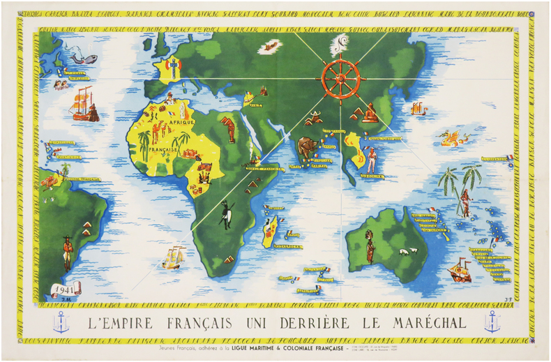
GOUVERNEMENT de VICHY.
[PROPAGANDE SECONDE GUERRE MONDIALE] L'Empire français uni derrière le Maréchal. Jeunes Français, adhérez à la Ligue Maritime & Coloniale Française.
1941. Affiche en couleurs de 305 x 470 mm.
Bookseller reference : LBW-7405
|
|
|
Government of British Columbia
British Columbia Invites You To the Land of the Golden Twilight (document 25M-330-9790)
36 pages. Incudes 17 pages of maps of Provincial locales. Sepia-tone reproductions of photos of picturesque Provincial scenes. Unmarked. Average wear and external soiling. Binding intact. A sound copy of the lovely B.C. tourism memento. Book

|
|
|
GPO. 1933.; 2 large foldout maps. Illustrator G. P.
Sailing Directions for the Pacific Islands Eastern Groups Volume II
G.P.O Washington D.C 1/1/1933. Hardcover. Good. Supplement to Hydrographic Office Publication No. 166 Bound in publishers olive cloth. Gilt lettering to front cover and spine. Good binding and cover. Soiling to boards and spine. Errata intensively throughout volume updated from 1936 as noted by errata title page. Name to front pastedown. Soiling to title page. Tanned pages. Wear to a few pages. Ships daily. G.P.O, Washington, D.C hardcover
Bookseller reference : 1511100003
|
|
|
GRAF, J.H. & LOCHMANN, J.J.:
Index général et compléments pour les fascicules IIa-c, contenant géodésie suisse, catalogues de collections de cartes, cartes, plans reliefs et panoramas. / Generalregister, Ergänzungen und Nachträge zu den Fascikeln II a-c. ‘Bibliographie der schweizerischen Landeskunde’, Fasz. IId.
Bern, Wyss, 1896, gr. in-8°, IV + p. 491-712 + XXVI, brochure originale.
Bookseller reference : 11422aaf
|
|
|
Graham Eleanor Editor Illustrated by Maps and Design By Gary Gore
Nashville: A Short History and Selected Buildings
Historical Commission of Metropolitan Nashville-Davidson 1974 1974. paperback. Very Good. 8x5x0. Maps and Design By Gary Gore. Historical Commission of Metropolitan Nashville-Davidson, 1974 paperback
Bookseller reference : 250821137
|
|
|
Graham, Eleanor, Editor, Illustrated by Maps and Design By Gary Gore & Maps and Design By Gary Gore
Nashville A Short History and Selected Buildings
Historical Commission of Metropolitan Nashville-Davidson 1974. Near Fine. 1974. Softcover. Near Fine softcover edition no names or marks. Minor shelf wear to cover. ; 8vo 8" - 9" tall; 288 pages . Historical Commission of Metropolitan Nashville-Davidson, 1974 paperback
Bookseller reference : 33860
|
|
|
Graham, JD. and 2 Maps and One Barometric Profile (all folding) J. D.
Report of the Secretary of War Communicating in Compliance with a Resolution of the Senate the Report of Lieutenant Colonel Graham on the Subject of the Boundary Line Between the United States and Mexico Hardcover Graham J.D. and 2 Maps and One Barometric Profile all folding
Hardcover. Very Good. SIGNED by the topographer Col. Graham and apparently amended by him or someone with same contemporary hand. Please see our pics. Senate Document 121; 1852; Hardcover; Very Good; Original brown cloth with title "Report of Col. Graham Mexican Boundary in gilt on front. " 250 pages plus the 2 maps and the barometric report. Text is lightly foxed throughout but completely readable fascinating content. Folding maps & report very good faintly foxed small closed tears as pictured. Well-bound and subtly ex-library. hardcover
Bookseller reference : 1030X61IJR6
|
|
|
Graham, Melissa
Trans Canada Rail Guide
Appears unread. No marks or inscriptions. No creasing to covers or to spine. A lovely clean very tight copy with bright unmarked boards and no bumping to corners. 256pp. With rail routes and maps plus city guides to most Canadian cities.

|
|
|
GRALL, Jeanne.
1944 : Le Calvados en images.
Hardcover in-4, 121 pages illustrees en n&b, cartonnage illustre de l"editeur. Tres bel exemplaire (dos leg. insole). [P-38]
|
|
|
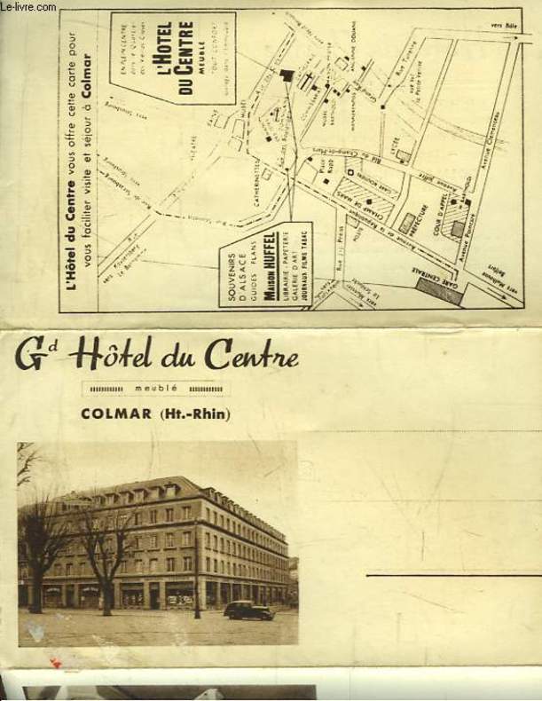
GRAND HOTEL DU CENTRE, à COLMAR
Carte Postale Ancienne Publicitaire du Grand Hôtel du Centre, Colmar (Haut-Rhin)
CHEZ L'AUTEUR. Non daté. In-8. En feuillets. Bon état, Couv. convenable, Dos satisfaisant, Intérieur frais. Carte Postale dépliante en 3 volets. Quelques photos en héliogravure et un plan en noir et blanc.. . . . Classification : 220-Cartes Postales Publicitaires
Bookseller reference : RO80092901
|
|
|
GRAND TREMBLEY. . .
Carte au 1/20 000e. Sans date.
Une feuille 46x64 cm.
|
|
|
GRANDIDIER (Alfred), MILNE EDWARDS (Alphonse)
Histoire physique, naturelle et politique de Madagascar. Zoologie.
Paris, Imprimerie Nationale, 1875-1890, 4 volumes grands in-4° (34x25,5cm), 2ff.-IV-396pp., reliure très amateur, quelques planches détachées, 1 ébarbée, rousseurs au texte et à quelques planches, manque les titres du volume 3, première et seconde partie, planches reliées de façon aléatoire. Les quatre premiers volumes de la section zoologique, consacré aux lémuriens, comprenant les volumes VI (texte), IX et X (en 2 parties) de la monumentale Histoire physique et politique de Madagascar, complets des 304 planches sur 302 feuilles (planche 79bis, la planche 238 n’a jamais parue), en coloris ou en bistre, dont 2 à double page, représentant des spécimens dans leur milieu ainsi que des planches anatomiques de squelettes, systèmes nerveux et musculaires.
Bookseller reference : PHO-2121

|
|
|
GRANDIDIER Guillaume
Atlas des colonies françaises. Protectorats et territoires sous mandat de la France
Paris Société d'éditions géographiques, maritimes et coloniales s.d. [1934] in-folio demi-toile marron à coins, dos lisse muet, titre poussé sur le plat supérieur [reliure de l'éditeur], fente à une charnière, qq. taches sur le plat supér
Bookseller reference : 39286
|
|
|
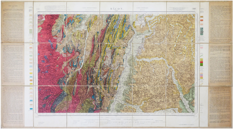
GRANDJEAN (François).
[MÂCON/GÉOLOGIE] Carte géologique détaillée. Mâcon. Feuille n°148.
1941. En 21 sections montées sur toile et repliées, formant une carte de 0,65 x 1,19 m ; étiquette au dos.
Bookseller reference : LBW-7868
|
|
|
GRANDPRÉ, Louis Marie Joseph O'Hier de
Voyage à la côte occidentale d'Afrique, fait dans les années 1786 et 1787 contenant la description des moeurs, usages, lois, gouvernement et commerce des états du Congo, fréquentés par les Européens, et un précis de la traite des Noirs, ainsi qu'elle avait lieu avant la Révolution Française ; suivi d'un voyage fait au Cap de Bonne-Espérance, contenant la description militaire de cette colonie.
Paris, Dentu, 1801. 2 vol. in-8, (2) ff., 226 pp. ; (2) ff., 320 pp., 2 cartes, un plan et 8 pl. dépl., mouillures claires, relié demi-veau à coins de l'époque , dos lisse avec pièce d’auteur et titre , mouillure au 1er tome sur les 10 premiers feuillets , déchirures aux plis de 2 gravures.
Bookseller reference : PHO-1139

|
|
|
GRANGEZ
CARTE DEPARTEMENT DU CALVADOS
1950 rel. toil. rouge in-12, d. passé, étiquette éd. / 1er pl., carte en coul. avec les armes de caen, région nord n ° 15, carte imprimée par monin, revue et rectifiée par grangez, et gravée / acier par laguillermie et abel malo - s.d. - atlas des départements de france
Bookseller reference : 936
|
|
|
Grant, Christina Phelps & Illus. with Maps & Plates
The Syrian Desert: Caravans Travel And Exploration
MacMillan. Fair with no dust jacket. 1938. Hardcover. Exlibrary with usual library markings. Some cover wear. Replaced endpapers. Some page yellowing. A comprehensive historical account of the Syrian Desert's role in trade travel and cultural exchange. Originally published in 1937 the book delves into the desert's significance over more than three millennia highlighting its function as a crucial link between the Mediterranean and Mesopotamia. ; 410 pages . MacMillan hardcover
Bookseller reference : 260037
|
|
|
Granzer, Randolf
Reichenberg - Stadt Und Land Im NeiBetal
796 pages. Written in German. Abundantly illustrated with black and white photographs. Includes two detailed maps stored in pocket inside back board. "Dieses Buch sollte ein Werk unseres hochverdienten Heimatfreundes Josef PreuBler werden. Es kam nicht dazu. Der Tod riB dieson besten Kenner unsurer Heimat and Bewahrer ihrer werte viel zu fruh aus unserer Mitte. Bis zur Halfte des 18. Jahrhunderts war die "Geschichte" fertiggestellt. Doch die Vielen LebensauBerungen unserer Stadt auf allen Gebieten der Kultur, Wirtschaft und Kunst blieben ungeschrieben. Wie aber wuBte er unsere Heimat gerade aus dieser Sicht in unzahliegn Vortragen, Beitragen, besonders fur die Reichenberger Zeitun und in Buchern vollendet darzustellen! Auch das Reichenberger archiv verdankt ihm eine Sammlung wertvollster Unterlagen, die er durch sein Ansehen in einem groBen BekanntenKreis und durch einen jahrelangen, umfangreichen Briefwechsel gewinnen konnte. So war reiches Material vorhanden, das nun fur den ganzen Inhalt des Buches verwendet werden konnte. Ohne seine bemuhungen hatte es nicht geschrieben werden konnen. So gesehen ist es in den Grundlagen auch sein Werk." - from Author's Foreward. Blue cloth boards decorated with partially worn gilt lettering and graphic. Front hinge open. Bit of writing upon front endpaper and reverse side of one map, else generally clean and unmarked. Contents partially yellowed. Average wear to book. Dust jacket heavily worn. Remains a useful copy. Book
|
|
|
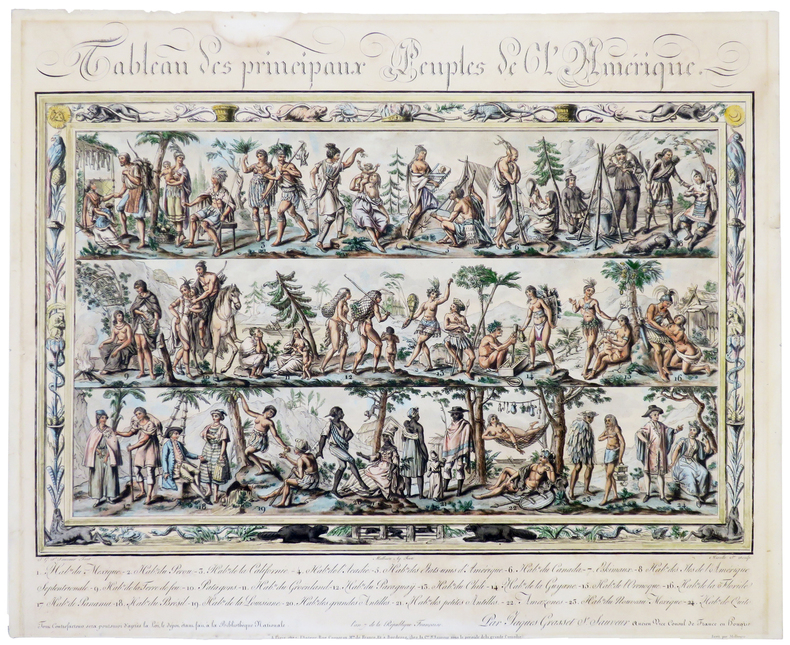
GRASSET de SAINT-SAUVEUR (Jacques).
Tableau des principaux peuples de l'Amérique.
Paris, chez l'auteur, An 7 [1799]. 417 x 497 mm, montée sur carton et sous passe-partout.
Bookseller reference : LBW-5392
|
|
|
GRASSET de SAINT-SAUVEUR (Jacques).
Tableau des principaux peuples de l'Europe.
Paris, Bance, le jeune An 7 [1799]. 515 x 612 mm.
Bookseller reference : LBW-5390

|
|
|
GRASSET DE SAINT-SAUVEUR (Jacques).
Voyages pittoresques dans les quatre parties du monde, ou troisième édition de l’Encyclopédie des voyages, Contenant les Costumes des principaux Peuples de l’Europe, de l’Asie, de l’Afrique, et des Sauvages de la mer du Sud ; gravés et coloriés avec soins. Suivis d’un Précis historiques sur les Mœurs de chaque Peuple. Planches Seules
Paris, Madame veuve Hocquart, 1806, in-8, sous étui, 123 planches (160) en couleurs, gravées par Lachaussée Jeune, de costumes d'Europe (50 sur 80), d'Asie (34 sur 36), d'Afrique (18) et d'Amérique (21 sur 22), accompagnées de 5 cartes en couleurs (Amérique septentrionale, Amérique méridionale, Afrique, Asie, Europe, toutes datées de 1806, sur 6), manque les 4 frontispices, tache sur une planche sinon aucun défaut.
Bookseller reference : PHO-1894

|
|
 Receive by email
 Download as PDF document
 RSS feed


