|
Philip's Maps
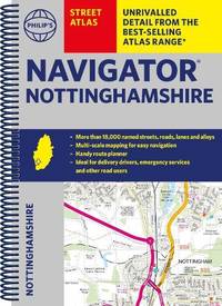
Philip's Navigator Street Atlas Nottinghamshire
Spiral bound. New. New Book; Fast Shipping from UK; Not signed; Not First Edition; The only county Street Atlas with all the named streets of Nottinghamshire and perfect back-up for emergency services delivery drivers visitors and locals. unknown
Bookseller reference : ria9781849076418_inp ISBN : 1849076413 9781849076418
|
|
|
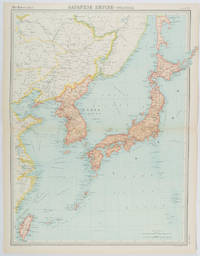
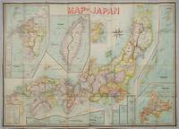
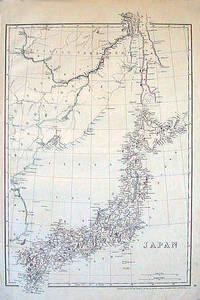
[JAPAN - MEIJI ERA MAP] BATHOLOMEW, JG. J. G.
Japanese Empire - Political.
Edinburgh.: John Bartholomew & Son Ltd. 1922. Large double page map 54.2 x 43 cms map original fold some edge toning and to the fold but in very good condition. Large map prepared as plate 65 for “The Times Survey Atlas of the World” in 1922 and was prepared at the Edinburgh Geographical Institute under the direction of J G Bartholomew. The map shows Japan's territory inclusive of Korea southern Sakhalin and Taiwan. . John Bartholomew & Son Ltd. unknown
Bookseller reference : 215880
|
|
|
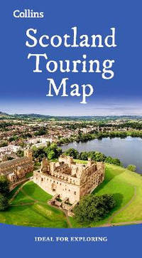
Collins Maps
Scotland Touring Map: Ideal for exploring
Sheet map folded. New. Explore new places with this up-to-date map of Scotland. <p>Best-selling map of Scotland. More than 1000 places of tourist interest plotted and named on the map. The features have been plotted onto an up-to-date and attractive Collins map of Scotland.</p> unknown
Bookseller reference : A9780008665012 ISBN : 000866501x 9780008665012
|
|
|
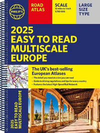
Philip's Maps
2025 Philip's Big Road Atlas of Europe: A3 Spiral Binding
Spiral bound. New. The <i>2025 Philip's Big Road Atlas of Europe</i> from the market leader contains all the maps and useful information you need for travelling by road and rail. Large A3 size with practical lie-flat spiral binding. unknown
Bookseller reference : A9781849076586 ISBN : 1849076588 9781849076586

|
|
|
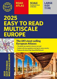
Philip's Maps
2025 Philip's Easy to Read Multiscale Road Atlas Europe: A4 Spiral binding
Spiral bound. New. The latest edition in Philip's best-selling European Atlas range the <i>2025 Philip's Easy to Read Multiscale Road Atlas of Europe </i>contains all the mapping and information you need for driving in Europe - and some rail options too. unknown
Bookseller reference : A9781849076609 ISBN : 184907660x 9781849076609
|
|
|
Philip's Maps
2025 Philip's Easy to Read Multiscale Road Atlas of Europe: A4 paperback with flaps
Paperback / softback. New. The latest edition in Philip's best-selling European Atlas range now in a practical paperback format with place-holder flaps. The <i>2025 Philip's Easy to Read Multiscale Road Atlas of Europe </i>contains mapping at the best scales for driving in Europe alongside the rules and regulations for every country. paperback
Bookseller reference : A9781849076593 ISBN : 1849076596 9781849076593
|
|
|
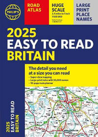
Philip's Maps
2025 Philip's Easy to Read Road Atlas of Britain: A4 Paperback
Paperback / softback. New. <b>The detail you need - at a size you can read </b>now in paperback<b>. </b> No more squinting to read the index or guessing whether that really <i>is</i> the village you want. Philip's new range of super-clear large-scale maps means that <b>everyone</b> can go places more easily. paperback
Bookseller reference : A9781849076654 ISBN : 1849076650 9781849076654
|
|
|
Kingsolver, Barbara; Cartes, Rebeca
Otra America / Another America
Seal Pr Feminist Pub . Used - Very Good. May have light to moderate shelf wear and/or a remainder mark. Complete. Clean pages. Seal Pr Feminist Pub unknown
Bookseller reference : 1408337 ISBN : 1580050042 9781580050043

|
|
|
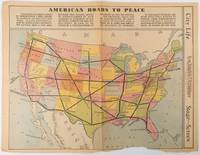
[PICTORIAL - PRE WWII MAP] BURKE, HOWARD AUSTIN [1899-1967.]
American Roads to Peace
Los Angeles.: Los Angeles Examiner. Sunday 1 May1938. Printed colour pictorial map 33 x 48 cms; 41.8 x 54.5 cms sheet central fold sheet toned corners chipped with some loss to the bottom border and at the central fold in good condition; and on the verso "Movie-Go-Round" by Louella O. Parsons black and white photos and advertisements. Pictorial map printed for the weekend supplement of the Randolph Hearst owned newspaper the Los Angeles Examiner. The map-maker and artist Howard Burke had also worked for the San Francisco Examiner and was known for pictorial maps many with a persuasive or rhetorical edge and as here were designed to shore up American patriotism and defences against a wider world in the increasingly turbulent pre-war 1930s. The caption to this map outlines a multi-billion dollar 25 year proposal by Congressman J. Buell Snyder for a network of coast to coast transcontinental highways "in case of an attack by a foreign power at any point along the border". Buell Snyder earned the soubriquet "the father of superhighways" and during the War he was assigned to a Congressional Committee in charge of appropriations for the War Department. Scarce. . Los Angeles Examiner. unknown
Bookseller reference : 215547
|
|
|
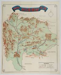
[JAPAN - YAMANASHI - MAP]
Yamanashi Prefecture Sight-Seeing Guide Map.
Kofu.: Onkodo Printing Co. circa1930s. Colour pictorial map 70.2 x 56 cms; 75.5 x 59.5 cms sheet light wear along the inner margin some soft creases from folding short split at center fold; in very good clean condition. An appealing and decorative map of Yamanashi Prefecture which while a process print has the attractive soft look of a lithograph adorned with vignettes of key attractions landmarks such as Mt. Fuji and industry such as silk and wine. The legend lists Railways 'Footing' Roads Hot Springs Hotels and National Parks. A scarce and attractive English language map for the tourist market. . Onkodo Printing Co., unknown
Bookseller reference : 206841
|
|
|
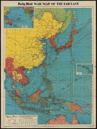
[WORLD WAR II MAP OF EAST ASIA].
The Daily Mail War Map of the Far East.
London.: George Philip & Son. 1944. Full colour folding map 101.5 x 76cm sheet inset maps legend folding into title wrapper 25.7 x 19.4 cms covers a little dusty and discoloured a few short fold splits without loss but the map in very good bright condition. Map of the Pacific Theatre of World War II with borders drawn as they stood in 1937 - complete with Chinese claims on Mongolia Tuva and Tibet. <br> <br>Shows transportation routes principal railways oil fields Allied naval bases territory occupied by the British Empire French Empire and the United States. This map shows only the northernmost section of Australia which allows for much better detail of the countries of East Asia. Small inset map of the Hawaiin Islands at mid right. Inset map of the Pacific Ocean at upper left. . George Philip & Son. unknown
Bookseller reference : 205765
|
|
|
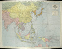
[ASIA - WORLD WAR II MAP].
The Daily Telegraph War Map of the Far East. Daily Telegraph War Map No. 11.
London.: Hutchinson & Co. Circa1940. Full colour folding map 70.7 x 93 cms; 76 x 101.2 cms sheet original folds short fold splits previous owner's neat title markings on the verso but the map in very good condition. A "Geographia" map of the war theatre in Asia and the Pacific including the northernmost coast of Australia. Showing railways and canals roads and steamer routes oilfields and pipe lines and a key to the unfederated states of Malaya. The Spratley Islands are marked as French and Thai territorial claims within French Indo China are marked. . Hutchinson & Co. unknown
Bookseller reference : 205763
|
|
|
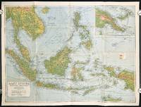
SOUTHEAST ASIA WORLD WAR II ERA MAP
East Indies. Mercators Projection. Map No. 316.
Sydney.: H.E.C. Robinson Pty. Ltd. circa1940. Full colour folding map 71 x 97 cms; 76.2 x 10² cms sheet blank on verso save for a neat inked stamp "East Indies" inset map of New Guinea and Papua heights shown by colour very good clean condition. Large scale World War II era map by Sydney publisher H. E. C. Robinson. Extremely detailed map it is coloured according to height above sea level and showing naval bases railways shipping routes air routes. Includes smaller inset map of "New Guinea & Papua" showing the eastern part of the island. . H.E.C. Robinson Pty. Ltd. unknown
Bookseller reference : 211106
|
|
|
[WWII MAP OF JAPAN] TSUTSUKI, T.
New Map of Japan.
Tokyo.: Nihon-Kenkyusha. 1935. Large folding colour map of Japan 74.3 x 10⁵ cms; folding into printed card covers 27 x 19.5 cms: 9 insets: Chosen Korea; Hokkaido; Chisima Islands; General Map of Japan and Manchuokuo; Karafuto Saghalien; Okinawa Loochoo; Taiwan Formosa; Micronesia; Ogasawara; Hajijoshima; the covers a litle worn and marked and the sheet slightly toned but the map is in very bright clean condition. Scarce World War II era map of Japan including Korea published in English by Kenkyusha. Founded in 1907 it had a history of publishing for students of English and the English market. An attractively composed map in remarkbable condition; with the insets circled around the islands of Japan heights marked in graduations from green to red and showing provinces railways roads steamer routes Buddhist and Shinto Temples. . Nihon-Kenkyusha. unknown
Bookseller reference : 214827

|
|
|
[WORLD MAP - WORLD WAR II]
World News of the Week. Monday Apr. 13 1942. Covering period Apr. 3 to Apr. 9. Military Edition.
Army Orientation Course. / News Map of the Week Inc. Volume 4 No. 32. 13 April1942. Folding colour pictorial map on sheet 88 x 119 cms blank on verso inset maps two photographic diagrams and black and white photographic illustrations descriptive text top edge chipped a few short edge tears and lower corner torn no loss pinholes at the corners inoffensive tidemark at a lower corner in good condition. Colour world map showing political boundaries and military events of World War II from April 3 to 9 1942. with descriptive text beneath including: the loss of two British Cruisers off Ceylon; the occupation of Bataan by the Japanese and their landing on Manus; Japanese war tactics revealed by Malay prisoners and the increasing importance of Central Africa to the Allied war effort. The. Map is indexed according to these notes. Two inset maps of Europe chart Hitler's gains in 1941 and activity on the Russian Front. Additional diagrams on the main world map show war spending and the civilian and war output of US industries. . Army Orientation Course. / News Map of the Week, Inc. unknown
Bookseller reference : 202620

|
|
|
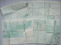
[VIETNAM WAR - MAPS]
A Series of Five Adjoining Vietnam War Era Maps.
Washington D.C.: Army Map Service. 1967-1968. Five printed colour adjoining topographic maps folded legends to physical features including roads some including footpaths or trails railroads rivers streams lakes mountains boundaries and place names Route Markers Railroads airfields bridges and detailed terrain a few including tea plantations rice fields coffee and rubber plantations. glossary of Vietnamese terms in very good unused condition: <br> <br>1. Special Use S.E. Asia. Xuat-Banlan Thu. Sheet 6026. Series L607. <br>Map 57.3 x 73 cms sheet inset map of Hon Khoai Island; <br> <br>2. Special Use S.E. Asia. Sheet 5927. Series L607. Khoang Cach Deu Vong Cao-DQ. <br>Map 72.3 x 57.3 cms sheet. he Viet Cong stronghold of Quan Long Cà Mau is shown; <br> <br>3. Special Use S.E. Asia. Sheet 6027. Series L607. Vietnam. <br>Map 72.3 x 57.3 cms sheet legend showing boundaries villages elevation and hydrographic data glossary of Vietnamese terms in very good unused condition. Southeast Vietnam and the Mekong delta. The town of Vĩnh Lợi Bạc Liêu is at the mid right edge of map.; <br> <br>4. Special Use S.E. Asia. Sheet 6028. Series L607. Vietnam. Do Cao Toi-da Duoi 5 met. <br>Map 54.5 x 54.5 cms 73.3 x 56.6 cms sheet; <br> <br>5. Special Use S.E. Asia. Sheet 5928. Series L607. Vietnam. Hon Rai. <br>Map 55 x 55 cms 74.3 x 56.7 cms sheet inset map of Hon Rai. <br>The caption has the note: "Dense forest or jungle indicates more than 25% of ground is concealed by canopy with undergrowth generally impassable on foot". Detailed topographic maps in unusually fine condition of Central and Southern Vietnam issued during the Vietnam War by the United States Corps of Engineers. . Army Map Service. unknown
Bookseller reference : 203843
|
|
|
[JAPAN & TAIWAN - MAP] OKISHIO, TAKACHIKA.
Map of Japan.
Kobe Japan.: Fuku-In-Kwan. 1906. Printed colour folding map on two conjoined sheets laid down 73.8 x 10⁵ cms foxing on verso not affecting map single pinhole in each corner scant spotting small fold splits no loss a few soft fold creases but in good condition. Very rare striking map of Japan published for the Western market. <br> <br>Created under the direction of Takachika Okishio featuring 10 inset maps: Chishima Kurile Islands Hokushu Hokkaido Ogasawara-Jima Bonin Islands Hachijo-Shima Ioshima Okinawa Saki-Shima Kyushu Saikaido Taiwan Formosa and Eastern Asia. The insets of Taiwan and Kyushu are the largest and centrally positioned. A Glossary and Explanation of Signs is printed at the foot of the map which list Towns Railway Stations Boundaries of Prefectures Notable Places Hot Springs Water-falls rapids Volcanoes Light-Houses Gold Silver and Coal-Oil fields. The Japanese Government Railway series of Travellers' Maps of Japan appear to have been modelled after this design. . Fuku-In-Kwan. unknown
Bookseller reference : 197908
|
|
|
[WORLD WAR II MAPS]
China Burma India War Sector etc. Chronology of Important War Events since December 7 1941.
Chicago.: Geographical Publishing Company. 1943. 10 printed colour maps on a large single sheet 91 x 71 cms small inset map of the European theatre chronology of events original folds a few short fold splits archivally sealed; in very good condition. A suite of numbered U.S. war maps with Allied action overstamped in red by the publisher that for Germany and France with pictorial stamps for strategic targets including "Chemical Factories" and "Airplane Factories". The maps numbered 1 to 10: English Channel; Italy; Southern Greece; Western Mediterranean Sea; Germany and France; Baltic Sea and Scandinavia; China Burma India; Japan; Tokyo; and Greater Pacific Battle Zone: a large half sheet map noting the placement of US and Japanese bases. The "Chronology of Important War Events" lists action from the bombing of Pearl Harbour: "Japan's day of Infamy: Japanese air attack cripples American Fleet at Pearl Harbour" to March 21 1944 "Germans take over key political posts in Bulgaria and Romania". <br> <br>Issued by the Geographical Publishing Company of Chicago this educational sheet includes an advertisement for WLS Chicago "The prairie farmer station" with a list of their war broadcasts and a world clock. . Geographical Publishing Company. unknown
Bookseller reference : 206908
|
|
|
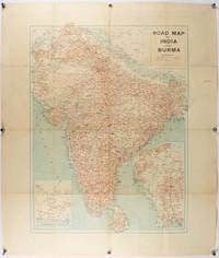
[INDIA - PRE PARTITION & BURMA - MAP]
Road Map of India and Burma.
Bombay.: Joshi & Co. circa1940. Colour lithographic map 66 x 50 cms; 81.x 68.5 cms sheet two inset maps and on the verso a full sheet "Relief Map of India" original folds with fold splits archivally strengthened several city names have been neatly underlined “Agartala” inked in the margin overall in good condition. Scarce Bombay-published map of the pre-Partition Indian sub-continent with two small inset maps one showing roads around Karachi and the other Burma. Through Routes Other Main Roads and Motorable Roads Subject to Weather are marked. The "Relief Map of India" on the verso includes Railway Lines Canals Steamer Routes Rivers Air Routes Navigable Canals and Broadcasting Stations. . Joshi & Co. unknown
Bookseller reference : 211089
|
|
|
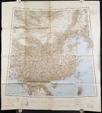
[1945 MAP OF CHINA]
China.
Calcutta: Compiled and drawn by the Survey of India. Second Edition. 1945. Large folding colour map 77.5 x 80cm; 95.5 x 86.2cm sheet including legend and small inset showing adjoining maps light toning and wear to upper margins and at corners and folds; but in very good condition. Very large clear map of China printed in 1945. The projection is noted as the "Lambert Conical Orthomorphic" a polyconic projection employed by the exhaustive Survey of India and the map includes surrounding countries: Taiwan Korea French Indo-China with a small inset key to Korean place-name abbreviations. As is typical of maps of this period Arunachal Pradesh is shown as Tibetan territory.The legend lists borders and provinces railways roads and canals with topography indicated with colouration. . Compiled and drawn by the Survey of India. unknown
Bookseller reference : 206545
|
|
|
[AUSTRALIA - ANTIQUE MAP].
Johnson's Australia.
Johnson and Ward. Circa1865. Hand coloured map 32.3 x 39.7 x cms including the decorative border; 35.6 x 45.8 cms sheet key to major centres unrelated text on verso sheet age toned in very good condition. Detailed map from the leading mid 19th Century American firm of Johnson and Ward. Although Tasmania was known as such from 1856 the map refers to "Van Diemen Land". . Johnson and Ward. unknown
Bookseller reference : 214355
|
|
|
[ANTIQUE WORLD MAP] (SMITH, ROSWELL CHAMBERLAIN), O. PELTON (ENGRAVER).
A Chart Exhibiting the Actual and Comparative Size of Each Country Nation or Kingdom; its Population as a Whole and to a Square Mile: Also the Different States of Society Forms of Government Religion &c.
Philadelphia.: W. Marshall. Circa1835. Handcoloured engraved map 26.5 x 41.3 cms; 29.6 x 48.3 cms sheet central fold insets of "Oceanica" and "New Holland" central table some light staining in the image and margins in good condition. Eurocentrism laid bare. This 19th Century map includes a "State of Society" for each part of the world declared with a symbol to represent "Barbarous Half Civilized Civilized and Enlightened Societies" as well as noting religion and ethnicity. It includes a table of distances between chief towns or capitals and between these towns and Washington DC. Australia "New Holland" is styled principally as pagan barbarous unexplored and African a thin sliver of what is now New South Wales and Victoria is labelled civilized European and Protestant. Scarce. . (W. Marshall). unknown
Bookseller reference : 203763
|
|
|
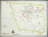
PHILIPPINES 1960S TOURIST MAP
Map of Baguio City Showing Some of Its Major and Minor Tourists Interests.
circa1960. Printed pictorial map 44.8 x 58 cms 46.7 x 60.3 cms sheet original folds a little wear but in very good condition. Attractive 1960s tourist map of Baguio city when it was the "Summer Capital" of the Philippines. Tourist attractions are shown pictorially in red blue triangles denote wood carving shops the city boundaries outlined in yellow sealed and unsealed roads are also shown. . unknown
Bookseller reference : 206510
|
|
|
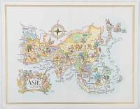
ASIA 1960S AVIATION PICTORIAL MAP. LIOZU JACQUES.
Asie. The President Special Pan American Menu.
Pan American World Airways. 1964. Colour pictographic/pictorial map of Asia 23.2 x 30.1 cms gilt double-rule border printed on a folding decorative menu card 32 x 50 cms open highlighted in gilt text in English French and Japanese central fold and later central vertical crease in very good condition. Pan Am menu card for First Class passengers dubbed "The President Special" the deluxe cuisine by fabled Maxim's of Paris "Good food is the basis for true happiness". Passengers were feted with gourmet meals on bone china with silver cutlery. The witty pictorial cover-map of Asia was by French artist and commercial illustrator Jacques Liozu 1910-1974 also known for his larger scale maps. . Pan American World Airways. unknown
Bookseller reference : 195995
|
|
|
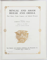
PLAYNE, SOMERSET (COMPILER), EDITED BY ARNOLD WRIGHT.
Bengal and Assam Behar and Orissa: Their History People Commerce and Industrial Resources.
London and New York.: The Foreign and Colonial Compiling and Publishing Co. 1917. Numerous black and white photographic illustrations. 768pp. Full red morocco binding spine lettered and ruled in gilt in compartments 'Tiger head' emblematical device stamped in gilt on the upper board repeated in gilt on the title page corner ornaments blocked in gilt. All edges gilt marbled endpapers light rubbing to corners but a lavishly produced edition in exceptional condition. 30 x 23.5cm One of a series of publications published with the object of supplying the British public with a picture - complete as far as literary and pictorial effort could make it - of the several different parts of the Empire. in this instance Northern India. . The Foreign and Colonial Compiling and Publishing Co. unknown
Bookseller reference : 214418
|
|
|
[WORLD WAR II MAPS] THOMPSON, KENNETH W. (ARTIST); ELIOT, GEORGE FIELDING.
Five WWII Bird's-eye View Maps including the Pacific and Southeast Asia.
Remington Rand. 1944. Five printed colour maps each: 31.4 x 47 cms; 46.3 x 53.3 cms sheet central fold marginal edge wear chips and a few small edge tears tidemark affecting the ocean at the outer edge of Map VII but all the maps in very good condition. From a series of World War II battlefront maps "for the delight of arm-chair strategists" published by the Library Bureau of Remington Rand seven were published. Taken from a bird's eye view of the globe and with relief artistically rendered by artist Kenneth Thompson 1907-1996 and descriptive text by George Fielding Eliot 1894-1971. Eliot spent his youth in Australia attending Melbourne University serving with distinction in the Australian Infantry in WWI. Moving to the United States after a short stint in Canada serving with the RCMP her served as a reserve officer in the U.S. Army reserve in military intelligence from 1922 to 1933 and during WWII Eliot famously broadcast the first extended television coverage following the attack on Pearl Harbor. He continued to write books and articles about military strategy and world politics into the 1960s. <br> <br>In keeping with the "aviation-age" cartography of Richard Edes Harrison the unusual perspective of the maps--from above and often with a direction other than north at the top of the map--challenges the viewer to reconsider the geopolitical situation with the text of Eliot as a further prompt his captions below: <br> <br>Map III Italy & South France "Hannibal Caesar and Napoleon made their reputations here" <br>Map IV The Western Front "Will the cockpit of 1918 see the decisive battles of 1944" <br>Map V Southeastern Asia "The road to Mandalay -- and to China --along which bombs for Tokyo must travel" <br>Map VI The Southwest Pacific "Island-hopping toward Japan -- in short and long hops" <br>Map V11 The North Pacific "Here the enemy trusts in the protection of vast ocean distances" . Remington Rand. unknown
Bookseller reference : 200808
|
|
|
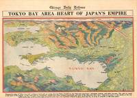
JAPAN TOKYO WORLD WAR II MAP GFROERER CURT ARTIST.
Tokyo Bay Area - Heart of Japan's Empire.
Chicago.: Chicago Daily Tribune. 28 July1945. Colour bird's eye view map 22.4 x 39.3 cms on a newspaper leaf trimmed to a half sheet 29.8 x 41.6 cms including caption slight toning at an old central fold the map in very good condition. <br>Unrelated black and white photographic illustrations on the verso "Pre-flight Trainers used in Chicago to give ground instruction to would-be pilots" and "New rekindled Montauk Light Long Island N.Y." Map published in the Chicago Daily Tribune days before the bombing of Hiroshima on August 61945. <br>"Perspective map of Tokyo bay and contiguous land and sea areas showing Tokyo Yokohama the Yokosuka naval base industrial sections and other features .In this map north is at the right instead of at the top - an expedient adopted to show all of the bay as large as possible in half page space." caption . Chicago Daily Tribune. unknown
Bookseller reference : 209335
|
|
|
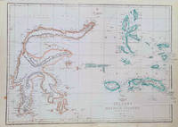
INDONESIA MAP OF SULAWESI & MALUKU ISLANDS WELLER EDWARD.
Celebes and the Molucca Islands.
London.: Weekly Dispatch Atlas. circa1860. Map with outline handcolour 31.3 x 43.3; 33.3 x 48.7 cms sheet 12 x 17 inches small marginal bloom not affecting the map in very good condition. Detailed mapping of these two island groups by Edward Weller 1819–1884 from the ‘Weekly Dispatch Atlas’ an atlas published in monthly instalments from 1855 for subscribers to the long running newspaper. Weller was a pioneer in lithography and was sought after for his skill in producing detailed and accurate maps. . Weekly Dispatch Atlas. unknown
Bookseller reference : 184035
|
|
|
[JAPAN - 1850S MAP]
Japan.
London.: Cassell Petter & Galpin. circa1852. Map with outline handcolour 42.5 x 30.1 cms; 49.2 x 34.3 cms sheet margins a little toned small corner crase but in very good condition. Very detailed map of the Japanese islands with Sakhalin above and the coast of Manchuria and Korea. . Cassell, Petter & Galpin. unknown
Bookseller reference : 185246
|
|
|
[CHINA - 18TH CENTURY MAP] PARISH, HENRY WILLIAM (MAPMAKER). BAKER, BENJAMIN (ENGRAVER).
A Sketch of the Pay-ho or White River and of the Road from Pekin to Geho taken 1793.
London.: George Nicol. 1796. Engraved copperplate map on Whatman paper 43.8 x 33.6 cm; 57 x 42 cm sheet including plate markscale in nautical and English miles; light undulation to sheet marginal toning and edgewear but in very good condition. Finely engraved and detailed map of two routes to Pekin Beijing along the White River Baihe from the Gulf of Petcheli and along the Imperial Highway from Jehol and includes commentary locating palaces and gardens type of cultivation "many barges" and "the road shaded by willow trees". The map elegantly drawn by Henry William Parish was published in George Staunton's account of Earl Macartney's embassy to China 1792-1794. . George Nicol. unknown
Bookseller reference : 209283
|
|
|
[INDONESIA - WWII MAP].
Java & Madura. 1:50000. Djombang. Sheet 53/XLIC. HIND 1090.
Washington D.C.: Army Map Service. First edition - revised AMS4. 1945. Army survey map printed in colour 36.7 x 36.7 cm; 58 x 48 cm sheet conversion graph glossary and administrative index to the inner margin; scale three column legend index to adjoining sheets and notes re grid references and mean declination to the foot; sheet toned a very few edge tears the map in very good condition. Wartime map produced by the US Army Map Service AMS who formed in 1942 and were at the forefront of military mapping campaigns during WWII and the post-war years. The very detailed map shows residency and administrative boundaries transportation ground and water features vegetation cultivation ruins religious sites "Graves; Chinese native" and "Cemetery; heathen Christian" walls hedges populated places built-up areas and buildings with those of iron stone wood and bamboo differentiated by colour; fishponds plantations and much more. . Army Map Service. unknown
Bookseller reference : 200411
|
|
|
[BRITISH INDIA AND CEYLON - MAP] NEELE, SAMUEL JOHN. (ENGRAVER)
British India Southern Part.
London.: Thomson. 1816. Engraved map with full handcolour 50.5 x 59.7 cms ; 53.9 x 73.8 cms sheet central fold a few minor edge tears one intruding into the top border the map unscathed marginal edgewear two corners with some loss but the map in very good crisp condition. An elegant map with great detail prepared for John Thomson's influential "New General Atlas" 1814-1821. Showing India from 20 degrees to 7 degrees north of the equator and includes the northern half of Ceylon with territorial interests attractively coloured. . Thomson. unknown
Bookseller reference : 185242
|
|
|
[JAPAN - WWII MAP] GFROERER, CURT. (MAPMAKER).
Japan's Main Islands - Where Americans Will Land.
Chicago.: Chicago Daily Tribune. August1945. Printed colour pictorial map on a single newspaper leaf 37 x 52 cms; 43 x 59.5 cms sheet three inset maps archivally laid down on linen very good condition. Full page map published in the "Chicago Daily Tribune" after the bombing of Hiroshima and Nagasaki prior to occupation by US and Allied forces in September 1945. "This is a new map of the main islands of Japan where American occupational troops will land and establish their military rule." map text The legend notes "Places bombed by U.S. Air Forces with a red circle" and "Cities bombed by Atomic Bomb" with a red star. The main map shows the Japanese islands of Honshu Shikoku and Kyushu with the Korean peninsula. Inset maps show Hokkaido Formosa and a general map of the area. . Chicago Daily Tribune. unknown
Bookseller reference : 208877

|
|
|
National Geographic Maps - Trails Illustrated
Big Bend National Park Day Hikes Map National Geographic Topographic Map Guide 1710
map. Good. Access codes and supplements are not guaranteed with used items. May be an ex-library book. unknown
Bookseller reference : 1566959063.G ISBN : 1566959063 9781566959063

|
|
|
HUGHES, WILLIAM.
A Manual of Mathematical Geography comprehending an Inquiry into the Principles of Mathematical Geography with Rules for the Formation of Map-Projections
London.: Longman Brown Green & Longmans. Second Edition. 1852. 5 folding mathematical projections at the rear. v 143pp plus 5 pages of publisher's adverts. Original cloth lettered in gilt on the spine and ruled in blind title page slightly browned head & tail of spine slightly chipped else a lovely clean copy. A presentation copy "With the Author's Cordial Regards' dated July 6th" 1854. 17.5x 10.5cm Born in Westminster London in 1818 William Hughes was a prolific mapmaker geographer engraver printer and publisher. . Longman, Brown, Green, & Longmans. hardcover
Bookseller reference : 180552
|
|
|
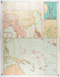
[ASIA-PACIFIC - MAP].
Robinson's Pacific Ocean Mercator's Projection. Map no. 1804 : New Map of the Pacific Ocean with Insets showing Island Groups in Detail.
Sydney.: H.E.C. Robinson. Circa1945. Full colour inset maps principal cities and towns marked shipping routes international boundaries and railways. 99 x 73cm. Some small insect damage has been repaired on the verso visible on map as a few small lighter areas in the western Pacific. Pinpoint holes at folds paper repair along cover but a very good clean copy. From the Sydney publisher H.E.C. Robinson the firm founded in 1895 by Herbert Robinson 1857-1933 a founder of the Royal Geographical Society of Australasia. <br> <br>Although the map is undated North and South Korea are shown as divided which occurred in late 1945 and Manchuria is marked as still under Soviet occupation which only lasted until 1946 at which point it was handed over to Communist China. <br> <br>As well as what now would be considered Southeast Asia the main map shows the eastern half of India Tibet and parts of Mongolia the USSR and East Asia. Inset maps include: Caroline Islands Marshall Islands Federation of Malaya Singapore Hong Kong Taiwan Japan Hawaiian Islands Philippine Islands Midway Gaum and Wake Islands Fiji Islands Eastern & Western Samoa Santa Cruz and Solomon Islands New Caledonia Rabaul Tahiti Lord Howe etc. . H.E.C. Robinson. unknown
Bookseller reference : 180206
|
|
|
Nelles Maps
India North East Bangladesh Nelles Maps
map. Good. Access codes and supplements are not guaranteed with used items. May be an ex-library book. unknown
Bookseller reference : 3865740383.G ISBN : 3865740383 9783865740380

|
|
|
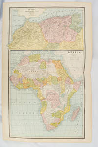
[AFRICA - MAP] CRAM, GEORGE F.
Africa and N. W. Africa Morocco Algeria & Tunis.
Chicago.: Geo. F. Cram. 1894. Chromolithographed maps 54.3 x 34.1 cm sheet central fold a few small edge tears and marginal age toning but in very good condition. Detailed maps prepared for George F. Cram's 1894 "Standard American Atlas": one of the first American firms to publish a world atlas. Maps of Oceania and South Africa printed on the verso. . Geo. F. Cram. unknown
Bookseller reference : 177068
|
|
|
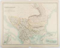
[TURKEY - ANTIQUE MAP] JOHNSTON, KEITH, FRSE. F. R. S. E.
Turkey in Europe.with Rumania Servia Montenegro Bulgaria &c.
Edinburgh & London.: W. & A. K. Johnston. 1893. Engraved map with original outline hand-colour 44 x 57.4 cm map two inset maps of the Bosphorus and Crete; central fold corners chipped with loss lower edge with several small marginal tears neatly repaired head and foot clipped at the fold with loss to the margin but the map in very good condition. Detailed and finely engraved map also showing submarine telegraph lines and relief by hachures. Re-issue of the map first published in 1863 for "Keith Johnston's Royal Atlas of Modern Geography". . W. & A. K. Johnston unknown
Bookseller reference : 177055
|
|
|
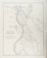
[EGYPT - ANTIQUE MAP] JOHNSTON, KEITH, FRSE.; JOHNSTON, W. & A. K. (ENGRAVERS). F. R. S. E.
Egypt Arabia Petræa and Lower Nubia.
Edinburgh & London.: William Blackwood & Sons. 1861. Engraved map with original outline hand-colour 57 x 43.8 cm 61.1 x 49 cm sheet central fold very slight edge toning but the map in very good bright condition. First edition. Fine large folding map: the Nile delta and river with attractive original outline colour railways and canals marked and name references to biblical and classical geography. Published for inclusion as map 39 in "Keith Johnston's royal atlas of modern geography" . William Blackwood & Sons. unknown
Bookseller reference : 177021
|
|
|
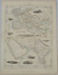
[TALLIS, JOHN], RAPKIN, J., WARREN H., AND KERNOT JH. J. H.
Overland Route to India and China
London.: The London Printing and Publishing Company. circa1850s. Lithographed map with original outline hand colour 33 x 24.5 cm including border and captions seven vignette illustrations two reference keys decorative border central fold light toning mainly at the central fold and to the verso of the sheet in very good condition preserved in a window mount. Attractive decorative map with fine vignettes of the London Post Office Suez Bombay Madras. Aden Malta Gibraltar and a wonderful camel train led by a carriage and horses crossing North Africa originally by the great mapmaker and publisher John Tallis. The two reference keys note steam packet routes railways electric telegraph and the Suez Canal. . The London Printing and Publishing Company. unknown
Bookseller reference : 177525
|
|
|
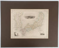
(TALLIS, JOHN), RAPKIN, J., WARREN H., AND KERNOT JH. J. H.
Japan & Corea
London.: The London Printing and Publishing Company. circa1850s. Lithographed map with original outline hand colour 25.8 x 33.5 cm three vignette illustrations decorative border central fold in very good condition presented in a window mount. Attractive decorative map with three vignettes by Rapkin: Yedo; a State barge in sail with penants flying--the paired oarsmen depicted through 10 small windows below deck; and Koreans in traditional costume; the map after the great mapmaker and publisher John Tallis. <br> <br>From the estate of the late collector and scholar Arthur Hacker with his pencilled catalogue mark on the verso. . The London Printing and Publishing Company. unknown
Bookseller reference : 177528
|
|
|
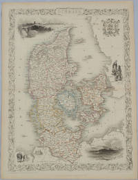
TALLIS, JOHN, RAPKIN, J. AND WINKLES H.
Denmark.
London & New York.: John Tallis & Company. Circa1850s. Lithographed map with original outline hand colour 34.5 x 24.7 cm including border and captionsfive fine vignette illustrations decorative border central fold edges with light toning in very good condition. Attractive decorative map with fine vignettes of Copenhagen Sleswig and Elsinore figures in costume the coat of arms of Denmark and an amiable equine pair by the great mapmaker and publisher John Tallis. . John Tallis & Company. unknown
Bookseller reference : 175779
|
|
|
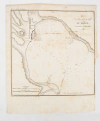
[CRIMEA - MAP]. TARDIEU, AMBROISE
Plan du Port at de la Ville de Kertch Anciennement Panticapée
Paris.: Librairie de Gide. 1839. Engraved map 21.1 x 20.8 cm 27 x 22 cm sheet original folds trimmed to the inner margin with slight loss to the border only map spotted but otherwise in sound condition. Map of the Port of Kerch in Crimea prepared for the 1839 edition of the French Journal "Nouvelles Annales des Voyages." the editors for this edition amongst others the translator and geographer Jean-Baptiste Benoît Eyriès and Alexander von Humboldt founding members of the world's first geographical society the Société de Géographie. . (Librairie de Gide). unknown
Bookseller reference : 175248
|
|
|
Berndtson Maps
Ireland
map. Good. Access codes and supplements are not guaranteed with used items. May be an ex-library book. unknown
Bookseller reference : 3865925626.G ISBN : 3865925626 9783865925626
|
|
|
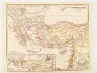
BYZANTINE EMPIRE MAP. SPRUNER KARL AND MENKE THEODOR.
Oströmisches Reich 1096-1204
Gotha: Justus Perthes. 1876. Map with original colour and outline hand-colour 32.2 x 40 cm text in German four inset maps central fold slight marginal toning and spotting on the verso but in very good condition. A most handsome and highly detailed map detailing the Eastern provinces of the Byzantine/Roman Empire before the Fourth Crusade. The inset maps depict Constantinople Divisions of the Empire and Antioch issued for the "Hand-Atlas für die Geschichte des Mittelatters und die Neueren Zeit" . Justus Perthes unknown
Bookseller reference : 174911
|
|
|
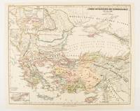
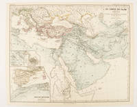
SPRUNER, KARL AND MENKE,THEODOR.
Länder am Ägäischen und Schwarzen Meer 1311 bis 1390.
Gotha: Justus Perthes. 1877. Map with original colour and outline hand-colour 32.2 x 40 cm two inset maps text in German central fold in very good condition. A most handsome map detailing countries on the Aegean and Black Seas 1311 to 1390. The inset maps depict the kingdom of Stephan Duschan Serbia and the land of the Crimean Goths issued for the "Hand-Atlas für die Geschichte des Mittelatters und die Neueren Zeit". . Justus Perthes unknown
Bookseller reference : 174915
|
|
|
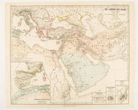
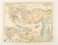
SPRUNER, KARL AND MENKE,THEODOR.
Die Länder des Islâm von der Hegra 622 n. Ch. bis zum Sturze der Umaijaden 750 n. Ch.
Gotha: Justus Perthes. 1877. Map with original colour and outline hand-colour 33.1 x 40.2 cm four inset maps text in German central fold slight marginal edge wear and spotting to the verso but in very good condition. A handsome map detailing the lands of Islam from Hegra in AD 622 to the fall of the Umayyads in AD 750. The inset maps depict a western extension to the main map and city plans for Damascus Jathrib & Medina and Mecca issued for the "Hand-Atlas für die Geschichte des Mittelatters und die Neueren Zeit". . Justus Perthes unknown
Bookseller reference : 174916
|
|
|
SPRUNER, KARL AND MENKE, THEODOR
Lateinische Herrschaften im Orient 1210 bis 1311
Gotha: Justus Perthes. 1876. Map with original colour and outline hand-colour 32.2 x 40 cm seven inset maps text in German central fold slight marginal toning in very good condition. A most handsome and highly detailed map detailing provinces of the Latin Empire in the wake of the Crusades. The inset maps depict Achaia in Greece Divisions of the Empire and a city plan of Constantinople issued for the "Hand-Atlas für die Geschichte des Mittelatters und die Neueren Zeit" . Justus Perthes unknown
Bookseller reference : 174910
|
|
|
SPRUNER, KARL AND MENKE, THEODOR.
Die Länder des Islâm unter den Abbâsiden bis zur Einnahme von Baghdâd durch die Bûjiden 750 bis 945 n. Ch
Gotha: Justus Perthes. 1877. Map with original colour and outline hand-colour 32.2 x 40 cm three inset maps text in German central fold slight marginal toning in very good condition. A most handsome map detailing the lands of Islam under the Abbasids up to the capture of Baghdâd by the Bûjids from 750 to 945 AD. The inset maps depict Northern Iraq Baghdad and a western continuation of the main map issued for the "Hand-Atlas für die Geschichte des Mittelatters und die Neueren Zeit". . Justus Perthes unknown
Bookseller reference : 174913
|
|
 Receive by email
 Download as PDF document
 RSS feed


