|
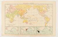
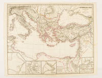
[WORLD MAP OF MAJOR RELIGIONS].
Religions of the World.
London.: Times Atlas of the World. 1895. Map printed in colour 23.2 x 35.9 cm. two edges gilt with three inset maps key to religions outlined in colour bottom margin chipped edges browned a few silverfish abrasions affecting the verso but in good condition. . (Times Atlas of the World) unknown
Bookseller reference : 175135
|
|
|
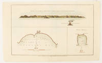
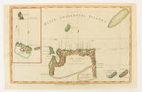
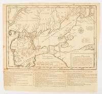
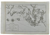
[PACIFIC - MAP] WALKER, JOHN (ENGRAVER).
The North side of Queen Charlotte's Islands as it appeared running along shore to the Westward.
London.: Alexander Hogg at the King's Arms. circa1784. Engraved map in triptych on laid paper 20.1 x 32.7 cm three insets: cross section of the north side of Queen Charlotte's Islands Solomon Islands with detail of a volcano "6 leagues North"; Swallow's Bay Harbour; and Byron's Harbour early hand colour trimmed to the plate mark at the top edge neat sealed tear affecting the publisher's caption slight edge wear and paper toning but a most attractive map in very good condition. Attractive engraving of the Queen Charlotte's Islands Solomon Islands. The Islands were named for the consort of King George III by Philip Carteret the British naval officer and explorer who participated in two of the Royal Navy's circumnavigation expeditions in 1764–66 and 1766–69. His ship the Swallow gave her name to the Bay and Carteret's commanding officer on the first of his voyages John Byron to the Harbour depicted in this most attractive early chart. . Alexander Hogg at the King's Arms. unknown
Bookseller reference : 174896
|
|
|
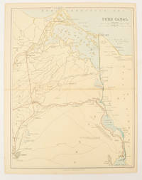
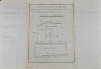
[EGYPT - MAP].
Suez Canal.
London Edinburgh & Glasgow.: William Mackenzie. 1880. Map printed in colour with original outline hand colour 29.8 x 22.7 cm central fold edge toning but in very good condition. Published for inclusion in "The National Encyclopaedia: A Dictionary of Useful Knowledge". . William Mackenzie. unknown
Bookseller reference : 174937
|
|
|
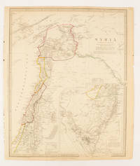
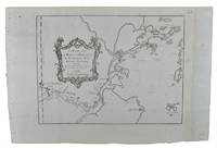
HUGHES, WILLIAM (CREATOR) WITH BURCKHARDT, JOHN LEWIS; CHESNEY, CHARLES CORNWALLIS; RENNELL, JAMES & ROBINSON, EDWARD.
Syria.
London.: Chapman & Hall. 1843. Engraved map with outline hand colour 39.4 x 31.4 cm inset map "Continuation from the Dead Sea to Mount Sinai" with finely engraved notes and a key to the Divisions under control of the Turkish Government manuscript pagination in an early hand to the top right edge tear nicks and browning but in very good condition. A most attractive map with detailed notes published when Syria was still under control of the Ottoman Empire. . Chapman & Hall. unknown
Bookseller reference : 174934
|
|
|
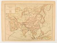
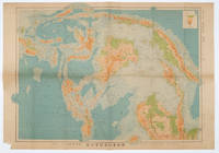
[ASIA - MAP.]
Physical map of Asia
New York.: Harper & Brothers. 1875. Map printed in colour polar projection 21 x 27.1 cm marginal spotting and toning small edge tears to the inner margin but in god condition. Prepared for "Harper's School Geography" first published by Harper & Brothers in 1875. The map shows physical features mountains steppes plains rivers and deserts etc. together with sources of primary production: whale fisheries furs coffe tea minerals etc.The verso of the map with references and attractive line engravings part of the entry for Netherlands and Belgium. . Harper & Brothers. unknown
Bookseller reference : 174830
|
|
|
[PACIFIC - MAP] WALKER, JOHN (ENGRAVER).
Queen Charlotte's Islands.
London.: Alexander Hogg at the King's Arms. circa1784. Engraved map on laid paper 21.4 x 33.7 cm inset of Gower's Simson's and Carteret's Island early outline hand colour trimmed to the plate mark at the top edge three small edge tears affecting the upper margin only slight paper toning but a most attractive map in very good condition. Fine impression of the Queen Charlotte's Islands Solomon Islands. It features the Swallow's track the ship's route taken by Captain Philip Carteret in 1767 the British naval officer and explorer who participated in two of the Royal Navy's circumnavigation expeditions in 1764–66 and 1766–69. . Alexander Hogg at the King's Arms. unknown
Bookseller reference : 174895
|
|
|
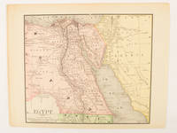
[EGYPT - MAP].
Egypt.
circa1890. Map printed in colour 18.9 x 22.4 cm central fold edge toning but in very good condition. . unknown
Bookseller reference : 174938
|
|
|
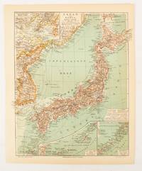
[JAPAN AND KOREA - MAP]. MEYERS, JOSEPH.
Japan und Korea.
Leipzig.: Bibliographisches Institut. 1902-1908. Map printed in colour 27.2 x 21.4 cm inset colour key to territorial administration by country inset "western continuation of the main chart" including the Gulf of Tschili and Tsientsin and two insets at the foot of the map to the Kuril and the Ryuku Islands text in Geman central fold slight edge toning but in very good condition. Attractive map text in German prepared for Meyers Großes Konversations-Lexikon. . Bibliographisches Institut unknown
Bookseller reference : 174898
|
|
|
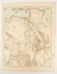
[AFRICA - MAP].
Africa North-East.
London.: Times Atlas of the World. 1895. Double-page folding map printed in colour 46.5 x 36.5 cm. edges gilt central fold with an inset map of Somaliland Somalia and the island of Sokotra key to European possessions outlined in colour small edge fold tears affecting the margin only and two other small edge tears slight toning at the edgaes but in very good condition. Attractive and detailed map prepared for the first edition of "The Times Atlas of the World". . (Times Atlas of the World). unknown
Bookseller reference : 175108
|
|
|
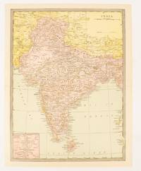
[BRITISH INDIA AND CEYLON - MAP].
India.
New York.: Bormay & Co. Circa1904. Map printed in colour 30.5 x 22.4 cm inset map of Calcutta and vicinity including the Nicobar and Andaman Islands at the outer edge slight puckering and discolouration at the central fold but in very good condition. . Bormay & Co. unknown
Bookseller reference : 174836
|
|
|
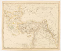
SOCIETY FOR THE DIFFUSION OF USEFUL KNOWLEDGE (SDUK), J & C WALKER (ENGRAVERS)
The Turkish Empire in Europe and Asia with the Kingdom of Greece.
London.: Charles Knight & Co. circa1840s. Lithographed map with original outline hand-colour 31.9 x 39.1 cm small marginal tears neatly repaired with archival material but no loss small surface abrasion affecting the border at the foot edgewear and browning inked pagination in an early hand but in very good condition. A handsome map with fine topographical engraving also showing the borders with Hungary Russia and Persia. . Charles Knight & Co. unknown
Bookseller reference : 174957
|
|
|
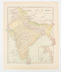
[INDIA - MAP.] FISK & CO. (ENGRAVERS)
India
New York. circa1910. Printed colour map 29 x 25 cm with inset map of the Eastern Part of India colour key reference key to the ruling divisions current and projected railways and telegraphs also shown central fold slight toning; in very good condition. Interesting map shaded by Divisions: the Presidencies of Bengal Madras Bombay Ceylon "Native States under British Protection" and "Independent States" Nepal and Bhutan. . unknown
Bookseller reference : 174839
|
|
|
BYZANTINE EMPIRE MAP. SPRUNER KARL AND MENKE THEODOR.
Oströmisches Reich zu Justinians Zeit.
Gotha.: Justus Perthes. Map with original colour and outline hand-colour 32.2 x 40 cm text in German five inset maps central fold slight marginal toning and spotting on the verso but in very good condition. A most handsome and highly detailed map detailing the Eastern provinces of the Byzantine/Roman Empire in the time of the Roman Emperor Justinian 527-565. The inset maps depict Carthage Rome Constantinople Naples and a Western continuation of the main map originally issued for the "Hand-Atlas für die Geschichte des Mittelatters und die Neueren Zeit" . Justus Perthes. unknown
Bookseller reference : 174950
|
|
|
MIDDLE EAST - MAP].
An exact map of the Crim formerly Taurica Chersonesus Part of Lesser Tartary the Sea of Asoph and the adjacent Country of the Kuban Tartars;.from the Charts sent by Generals Lucy and Munich in 1736 and 1737.
London.: The Gentleman's Magazine. circa1739. Engraved map 22.2 x 31.4 31.1 x 33 cm sheet size elaborate explanatory key in three columns at the foot original folds sealed 2 cm tear to the lower part of the inner margin one other small fold tear no loss inner margin of the key trimmed with some loss an original fault paper browned and spotted on the verso but an historic map in good condition. . [The Gentleman's Magazine]. unknown
Bookseller reference : 174921
|
|
|
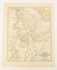
[MIDDLE EAST - MAP]. FISK & CO., (ENGRAVERS).
Egypt showing the Egyptian Soudan Arabia etc.
New York.: Hunt & Eaton. Circa1893. Printed map in colour elevation shown with hachures 29 x 23.5 cm text on the verso relating to entries for Afghanistan Beluchistan and Turkey prepared for Hunt & Eaton's "New York Recorder's Atlas" small tears to the top edge but in very good condition. . Hunt & Eaton. unknown
Bookseller reference : 174920
|
|
|
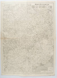
[LAND SURVEY DEPARTMENT, EMPIRE OF JAPAN]. 大日本帝国陸地測量部.
上海 支那江蘇省・浙江省. Japanese Map - Shanghai Jiangsu Province and Zhejiang Province.
Tokyo.: 大日本帝國陸地測量部. Dainihon Teikoku Rikuchi Sokuryōbu. Taisho 15. 1926. Folding colour Japanese map of Shanghai and coastal areas of Jiangsu and Zhejiang Provinces. Scale 1:100000 embossed stamp lower right corner. Legend lower edge showing different landforms on the left section forests deserts wildlands plateaus rivers and lakes middle section showing various facilities such as post offices telecommunication offices temples ancestral halls ancient battle ground mines military fortifications submarine communications cables city walls and gates etc. right section showing different sizes of cities towns and villages and administrative boundaries. <br> <br>Occasional foxing along edges and folds ink annotation in Kanji on reverse good copy. Text in Japanese. Sheet measures 45.2 x 57.7cm. This very detailed map was originally surveyed by the Land Survey Department Empire of Japan in Taisho 7 1918. This revised edition features the railway line connecting Hangzhou - Jiashan - Shanghai - Suzhou - Wuxi. . 大日本帝國陸地測量部. [Dainihon Teikoku Rikuchi Sokuryōbu]. unknown
Bookseller reference : 173266
|
|
|
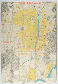
[ŌBUCHI ZENKICHI]. 大淵善吉.
最新京都市街地圖. Saishin Kyōto shigai chizu. Most Recent Map of Kyoto City.
京都. Kyoto.: 山中書房. Yamanaka Shobō. 大正 11 1922. Attractive colour folding map of Kyoto with a quite detailed illustrated tourist guide printed in blue and white on the reverse some light browning holes at some folds good copy. 78.5 x 54cm This 1922 colour folding tourist map of Kyoto offers sightseeing information each panel showing a photographic monochrome image of the site discussed. <br> <br>The two inset maps on the Kyoto map show Otsu city on the shore of Lake Biwa and the Arashiyama area north of Kyoto. The main map highlights the major temples and famous sights in red geographic features such as rivers and hills are shown and an inset chart shows distances of sights from the nearby stations. The information on the reverse gives more detail on the famous sights a calendar of events seasonal highlights and details of the Imperial graves around Kyoto. . 山中書房. [Yamanaka Shobō]. unknown
Bookseller reference : 171899
|
|
|
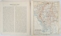
PETERMANN, AUGUST HEINRICH AND SCHMIDT, CARL (CARTOGRAPHER).
Burma map Britisch-Birma nach den neuesten Grenzbestimungen auf Grund amtlicher Quellen. from Petermann's Geographische Mitteilungen
Gotha: Justus Perthes. 1903. Map printed in colour 24.7 x19.4cm and leaf of descriptive text in German 26.5 x 22.5cm slight toning and edges of the map worn with two small tears no loss. Geopolitical map of Burma with railways and railways under construction highlighted. The accompanying text is by the German Tibetologist linguist and orientalist Dr Emil Schlagintweit. . Justus Perthes unknown
Bookseller reference : 173709
|
|
|
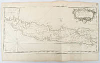
BELLIN, JACQUES-NICOLAS.
Idée de l'Isle de Java tirée des manuscripts Hollandois.
circa1750. Black and white copperplate engraving map of Java a little light even browning neat colour pencil highlighting of rivers and two settlements. Folded as issued. Good copy. 26 x 44cm. Issued in Prevost's Histoire Générale des Voyages ou nouvelle collection de toutes les relations de voyages par mer et par terre. . unknown
Bookseller reference : 136782
|
|
|
OSAKA MAINICHI SHINBUNSHA. EDITED BY. .
漢口戦局全図. Kanko senkyoku zenzu. Hankow/Hankou War Situation Map.
大阪. Osaka.: 大阪毎日新聞社. Osaka Mainichi Shinbunsha. 昭和 13 1938. Black and white map folded showing Hankow one of the three cities which merged to become Wuhan 54.5 x 49cm scale 1:2000000. Some light browning tiny closed tear upper margin neatly repaired with conservation standard tape. Good copy. This Hankow/Hankou War Situation Map is a supplement map of Osaka Mainichi Newspaper on 25 August 1938. The two inset maps show the region around Nanjing and Hong Kong. It gives detailed place names of Hankow area. . 大阪毎日新聞社. [Osaka Mainichi Shinbunsha]. unknown
Bookseller reference : 172829
|
|
|
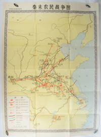
[MUSEUM OF CHINESE HISTORY] 中国历史博物馆.
秦末农民战争图. Qin mo nong min zhan zheng tu. Chinese Educational Map - Map of Peasant Rebellion during Late Qin Period.
Beijing.: 地图出版社. Di tu chu ban she. 1st Edition 2nd Printing. 1981. Large Chinese coloured educational map folded scale 1:2000000. Legend lower left corner shows the routes of military advance led by peasant rebellion leaders' 陈胜Chen Sheng and 吴广Wu Guang in red and other military activities led by 项羽Xiang Yu and 刘邦Liu Bang in various colours. In original worn paper wrapper map in very good condition. Text in Chinese. Map measures 105.5 x 76.6cm. . 地图出版社. [Di tu chu ban she]. unknown
Bookseller reference : 173280
|
|
|
[US. MAP OF CHITTAGONG & SURROUNDING REGION]. U. S.
Chittagong.
Washington D.C.: Army Map Service U.S. Army. 1955. Large colour map. 1:250000 scale. Transverse mercator projection. 23°00'N 91°30'E-22°00'N 93°00'E. Series U502 Sheet NF 46-6 Edition 1-AMS. Map measures 57.3 x 75.8cm. Slight wear creasing even light browning small closed tears on edges upper-right corner little foxed. Shows signs of use but map is clean and complete. Corps of Engineers Army Map Service map of Chittagong and surrounds compiled in 1955. Based on the British Indian one-inch and half-inch map series from 1938-43 and 1936-43 respectively. . Army Map Service, U.S. Army. unknown
Bookseller reference : 173072
|
|
|
STIELER, ADOLF; STUPNAGEL, FREDERIC VON AND BERGHAUS HERMANN.
Asia.
Gotha.: Perthes Justus. Circa1855. Engraved map 44.1 x 36.3 cm sheet size 35.8 x 29.7cm map size plate mark map with original hand colouring and hand coloured key noting Islamic "Mohammedanische" Buddhist "Buddhaistische" and European territories by country. Unusual map in an early issue. It was included as map 39 in Stieler's "Hand-Atlas uber alle Theile der Erde und uber das Weltgebaude by Frederic von Stulpnagel" revised by Hermann Berghaus in 1855. The issue is noted to the top right: Ausg. in 63BI. no XIV. Fine outline hand colouring denotes territories by religion and Chinese ports open to European trade and Japanese ports open to American trade. . Perthes, Justus. unknown
Bookseller reference : 173439
|
|
|
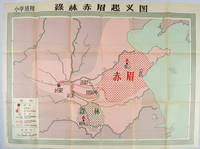
[HISTORY EDITORIAL OFFICE OF PEOPLE'S EDUCATION PRESS]. 人民教育出版社曆史編輯室.
绿林赤眉起义图. Lulin Chimei qi yi tu. Chinese Educational Map - Map of Lulin and Chimei Rebellion.
Beijing.: 地图出版社. Di tu chu ban she. 1st Edition 2nd Printing. 1958. Large Chinese coloured educational map folded. Scale 1:2000000 legend lower left corner showing the military advance of two peasant insurgent groups Lulin and Chimei's march towards the capital city Chang'an now Xi'an in 17 AD. In original worn paper wrapper map in very good condition. Text in traditional Chinese. Map measures 77 x 105.2cm. 王匡 Wang Kuang and 王凤 Wang Feng founded the Lulin Army in the region of modern Hubei Province. 樊崇 Fan Chong lead the Chimei also known as Red Eyebrows Army in the northern parts of modern Shandong Province. . 地图出版社. [Di tu chu ban she]. unknown
Bookseller reference : 171563
|
|
|
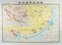
[NATIONAL MUSEUM OF CHINESE HISTORY]. 中国历史博物馆.
中法战争形势图. Zhong Fa zhan zheng xing shi tu. Situation Map of the Sino-French War.
北京. Beijing.: 地图出版社.Di tu chu ban she. 1978. Large Chinese map in colour showing southern part of China and northern Vietnam folded in original envelope scale 1: 150000 inset map upper left corner scale 1:800000. Both maps show the battles between Qing court and French army between 23 Aug 1884 and 25 Mar 1885. Original paper envelope repaired with acidic free tape map in very good condition. Text in Chinese. Sheet measures 76.8 x 107.1cm. . 地图出版社.[Di tu chu ban she]. unknown
Bookseller reference : 171343
|
|
|
[ZHU, YULIAN]. (CARTOGRAPHER). 朱育蓮 繪.
美國在日本的主要軍事基地圖. Meiguo zai Riben de zhu yao jun shi di tu. Map of Major U.S. Military Bases in Japan.
No publication details. Circa1955. Chinese black and white military map of Japan based on a map issued by 赤旗報 Shimbun Akahata on 24 June 1953. No scale given inset map of Hokkaido upper left corner legend lower section showing air and navy bases military exercise bases ammunition dump shooting ranges for the air force and navy headquarters of the coast guard etc. Text upper section provides details of the different types of US military bases and infrastructure. Text in traditional Chinese. 25.8 x 35.8cm. . No publication details. unknown
Bookseller reference : 172396
|
|
|
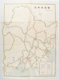
[KIKUCHI, KIYOSHI, EDITED BY]. 菊池清編輯.
満洲鉄道図. Manshu tetsudo zu. Railway Map of Manchuria.
奉天. Mukuden.: 満鉄鉄道総局. Mantetsu Tetsudo Sokyoku. 昭和 15 1940. Colour folded map seven small very holes not affecting the printed image otherwise good. 53 x 38.5cm Map showing the comprehensive railway network in Manchuria with names of all the stations. It includes the lines run by the South Manchurian Railway Company their temporary industrial lines light rail as well as the lines run by other Russian and Chinese companies. By 1940 the network had expanded so much that it included almost the whole of Manchuria. . 満鉄鉄道総局. [Mantetsu Tetsudo Sokyoku]. unknown
Bookseller reference : 172590
|
|
|
[KIZAKI, JUNICHI]. 木崎純一.
最新詳密蘇連極東地方大地図. Saishin shomitsu Soren Kyokuto chiho dai chizu Most Recent and Detailed Large Map of the Soviet Union and Far East Region.
東京. Tokyo.: 伊林書店. Ibayashi Shoten. 昭和14 1939. Colour printed folding map 78 X 109cm minor damage original envelope 27.5 x 20cm. Very good copy. This map offers comprehensive information on northern China Manchuria the Soviet Union and Hokkaido including Kuril Islands under the Japanese control. It also includes the Jewish Autonomous State which existed in the late 1930s. The inset map provides detailed information on the border area of Japan Manchuria and the Soviet Union. Legends include national borders railways major cities iron mines and oil wells. <br> <br>Published in 1939 this map is an expression of the tension Japan felt in its relationship with the Soviet Union. At the time the Soviet Union was seen as the mighty threat to the lying just north of Manchuria and Japan . . 伊林書店. [Ibayashi Shoten]. unknown
Bookseller reference : 171112
|
|
|
[QINGDAO IN 1938].
青島市街地図. Chintao shigai chizu. Japanese Plan of Qingdao City.
Qingdao: Taiheiyoko. 太平洋行. 昭和 13 1938. Coloured folding plan of Qingdao in 1938. some browning on reverse with a small lighter section on map Japanese place names no scale 36 x 39cm 3 inset maps. This 1938 Qingdao city map shows street names in Chinese characters and location of Chinese and Japanese public buildings such as the hospital shrines Japanese primary schools and high schools. The 3 inset maps show railway and transport routes as well as outskirts of the city. . [Taiheiyoko]. 太平洋行. unknown
Bookseller reference : 171093
|
|
|
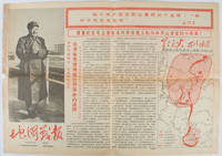
EDITORIAL UNIT OF WAR DISPATCHES OF MAP WORKERS' REPRESENTATIVE ASSEMBLY OF CHINA CARTOGRAPHIC PUBLISHING HOUSE REVOLUTIONARY C
地图戰報: 第6期. Di tu zhan bao: di liu qi. Chinese Cultural Revolution Maps - War Dispatches of Maps. Issue no. 6.
Beijing.: 地图戰報.Di tu zhan bao. September1967. Maps printed in red and black single sheet printed on both sides folded scale not given photographic image of Mao Zedong. Some light browning at edges with tears and losses on left edge still good. Text in Chinese. Sheet measures 26.5 x 38.4cm. Includes a map of Autumn Harvest Uprising and also shows the routes of the military advancing towards Jinggangshan between September and October 1927. On reverse left section a map shows the route along which Chairman Mao led the Fourth Army of the Chinese Red Army marching towards south of Anhui and Jiangxi Provinces in 1929. On reverse right section a map titled "The Long March of The Chinese Workers' and Peasants' Red Army October 1934-October 1935". Quotations of Chairman Mao about the Long March insert on corners of the map. <br> <br>Issue no. 6 of a series of maps with text issued by the Red Guards organisations in the form of Cultural Revolution tabloid-sized newspaper. This issue is designed to celebrate the 40th anniversary of the Autumn Harvest Uprising which was one of the earliest armed uprisings organised by the Chinese Communist Party. . 地图戰報.[Di tu zhan bao]. unknown
Bookseller reference : 169746
|
|
|
[INAGAKI, RIKICHI]. 稲垣利吉.
日・米・英・勢力圖太平洋上: 比較對照. Nichi bei ei seiryokuzu Taiheiyojo : Hikaku taisho. Military Strength of Japan the United States and the United Kingdom on the Pacific: A Comparison Map.
東京. Tokyo.: 九段書房.Kudan shobo. 大正十四 1925. Coloured folding Japanese map showing the military strength of Japan the United States and the United Kingdom in the Pacific original pictorial envelope scale not given. Some small holes at folds occasional light foxing a prior owner's signature on reverse minor wear envelope. Very good copy in like envelope. Map measures 54.4 x 78.8cm. The explanatory text in Japanese printed on the reverse in blue summarises the colonial possessions of the US and the UK as well as providing a comparison between the land size naval presence natural resources immigration issues and maritime transport capacities of Japan the United States and the United Kingdom. Legend indicates national regional provincial territorial boundaries canals undersea cables airline routes metropolitans capital cities mining fields hot springs ancient battle fields major trade ports Japanese embassies and consular offices. A large area marked 日本委任统治 "South Pacific Mandate" highlighted in a box is adjacent to Australian occupied Papua New Guinea. . 九段書房.[Kudan shobo]. unknown
Bookseller reference : 169329
|
|
|
[SURVEYING BUREAU OF THE PEOPLE'S LIBERATION ARMY GENERAL STAFF DEPARTMENT]. 总参谋部测绘局.
抗震救灾专用地图: 四川省全图./汶川县及周边地势图. Sichuan sheng quan tu./Wenchuan xian ji zhou bian di shi tu. Special Maps for Earthquake Disaster Relief: Map of Sichuan Province./ Map of Wencuan County and Its Vicinity.
北京.Beijing.: 星球地图出版社.Xing qiu di tu chu ban she. May2008. Two large coloured maps printed on double sided on a single sheet folded issued shortly after the devastating 2008 Wenchuan Earthquake which was occurred on 12 May 2008. Small tears along folds mended by both non-acidic tape and cello tape some creasing generally good. Text in Chinese. Sheet measures 84.9 x 119.7cm. <br> <br>Map of Sichuan Province: scale 1: 1100000 inset map lower right corner showing the provincial capital city Chengdu a statistical chart lower section listing counties within Sichuan Province their population and territory size. <br> <br>Map of Wenchuan County and Its Vicinity: 1: 300000 various colour representing altitude differences inset map showing the position Wenchuan County within Sichuan Province a mileage chart listing the distance between Wenchuan County to nearby cities. A brief introduction of Wenchuan on left section accompanying the images of the rescue forces. The Great Wenchuan Earthquake was the biggest earthquake in Chinese history with a casualty over 69000 people. . 星球地图出版社.[Xing qiu di tu chu ban she]. unknown
Bookseller reference : 169215

|
|
|
[WWII JAPANESE MAP OF AUSTRALIA].
標準大東亞分圖・オーストラリヤ篇 Hyōjun Daitōa bunzu daitōa bunzu: Ōsutorariyahen. Standard Maps of Greater East Asia: Complete Map of Australia.
Tokyo.: Tōseisha. Showa 18 1943. Folding colour map of Australia 54.2 x 76.4cm. Some foxing particularly along folds and upper right margins a few repaired tears and small holes at folds.With original sleeve. The 15th map in the Standard Maps of Greater East Asia series of 20 maps. Shows the natural resources such as sheep gold pearl diary regions opals etc. Tasmania appears as an inset in the bottom right corner. Text in Japanese. . Tōseisha. unknown
Bookseller reference : 162103

|
|
|
BELLIN JACQUES NICOLAS. CARTOGRAPHER.
Carte De La Baye De Chin-Chew ou Chang-Chew.
Paris. circa1749. Black and white engraved map of Quanzhou and Zhangzhou 21.1 x 30 cm here spelled Chin-chew and Chang-chew and both final words with added superscript "ou" on watermarked laid paper 25.6 x 38 cm original folds a few marginal spots simplified compass rose and a decorative fleur de lis bottom right in very good condition. Attractive map including the estuary of Quanzhou River Xiamen Emowi and Kinmen or Quemoy Quemowi island. The map was designed by the eminent French cartographer Jacques-Nicolas Bellin and here published as plate No. 22 in the impressive 15 volume compilation of voyages "Histoire Generale des Voyages" by Antoine François Prévost. . unknown
Bookseller reference : 136795
|
|
|
[BELLIN, JACQUES-NICOLAS]. (CARTOGRAPHER).
Plan De la Ville De Peking.
Paris. circa1749. Black and white engraved plan map of Peking on laid paper folded designed by the prominent French cartographer Jacques-Nicolas Bellin. This map is No. 18 Vol. 5 from the impressive 15-volume "Histoire Generale des Voyages" compiled by French novelist Antoine François Prévost. This city map shows two areas of walled cities: Ville Tartare Imperial city and the Forbidden City and Ville Chinoise ethnic Han residential area. <br> <br>Notes A and B represents buildings within the Forbidden City. A: Lieu de Plaisance ou l'on voit une Montagne faite a la main B: Grandes Cours du Palais de l'Empereur. Two missionary buildings French and Portuguese as well as the Tower of Mathematics illustrated within Ville Tartare. Two temples illustrated side by side near the south gate of the Ville Chinoise. <br> <br>Overall in good condition very light browning on edges and darker toning along the borders of the map. Text in French. Map measures 21 x 16.4cm. . unknown
Bookseller reference : 136794
|
|
|
BELLIN JACQUES NICHOLAS CARTOGRAPHER.
Carte de L'isle de Cheu-Chan ou Isle de Chusan de la Province de Che-Kiang Avec les Costes et Isles voisines.
Paris. circa1749. Black and white engraved map on watermarked laid paper 20.9 x 32.7cm showing coastal area of Zhejiang Province Province de Che-kiang including Zhoushan Archipelago Isle de Chusan Zhoushan Bay Bay de Chusan and Xiangshan County Siang-chan-luen a walled city outside of upper border Ningbo Ning-po prefecture under Qing administration title cartouche lower left original folds. This map is No. 3 Vol. 6 from the impressive 15-volume "Histoire Generale des Voyages" compiled by Antoine François Prévost. Even browning mainly to the sheet edges in very good condition. . unknown
Bookseller reference : 136826
|
|
|
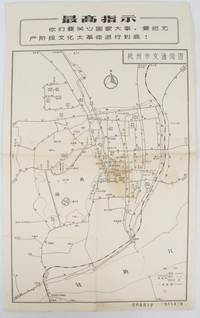
[HANGZHOU - MAP].
杭州市交通简图. Hangzhou shi jiao tong jian tu. City Transportation Map of Hangzhou.
1967. Vintage transportation black and white map of Hangzhou folded no scale a legend lower right corner shows bus/trolleybus routes and terminals. The map covers the old city of Hangzhou from the north side of the city 杭三中"Hangzhou No.3 High School" to the south side 钱江大桥 "Qiantang River Bridge". The West Lake is featured in the centre with its famous tourist spot 三潭映月 "Three Pools Mirroring the Moon" indicated. Bus/trolleybus routes connects schools hospitals municipal government departments cinemas department stores tourist spots around the West Lake etc are all shown on this map. <br> <br>Stained in the central section light wear along folds and edges otherwise good. Text in Chinese. Sheet measures 39.1 x 24.8cm The headline Chinese text in the box along the top of the map reproduces one of the highest directives from Mao's Quotations: "You must pay attention to state affairs and carry the great proletarian cultural revolution through to the end!" . unknown
Bookseller reference : 163238
|
|
|
[BELLIN , JACQUES-NICOLAS]. (CARTOGRAPHER).
Carte de La Baye d'Hocsieu et des Entrées de La Rivière de Chang.
Paris. Circa1749. Engraved map on watermarked laid paper 20 x 27.3 cm of Fuzhou and coastline of Fujian Province original folds designed by the great French cartographer Jacques-Nicolas Bellin. This map is from the impressive 15-volume "Histoire Génèrale des Voyages" compiled by Antoine François Prévost map no. 2 Vol. 6. This map shows the estuary of Yangtze River Rivière de Chang. Very light browning on sheet edges but in very good condition. . unknown
Bookseller reference : 136827
|
|
|
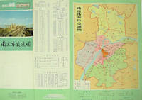
[NANJING MUNICIPAL INSTITUTE OF SURVEYING AND DESIGN]. 南京市勘测设计院.
南京市交通图. Nanjing shi jiao tong tu. Naning City Transportation Map.
No place of publication.: 江苏人民出版社.Jiangsu ren min chu ban she. 1st Edition 2nd Printing. 1977. Colour Chinese transportation map featuring the city of Nanjing capital city of Jiangsu Province and its surrounding regions. Upper side: A transpiration map of Nanjing and neighbouring counties right section with a list of names of stations buses trains coaches ferries and their addresses lower right edge tourist guide including the addresses and phone numbers of major travel agents hospitals cinemas and more left section accompanied by two tables of bus routes. On reverse: a "Map of Nanjing Municipal Transpiration Map" scale not given a chart of terminus for bus and trolley bus lower right section. Some soiling on reverse stamp of a prior dealer in Guangzhou a handwritten date of "September 17th 1977" upper side light creases good copy. Text in Chinese. Sheet measures 37.8 x 52.3cm. . 江苏人民出版社.[Jiangsu ren min chu ban she]. unknown
Bookseller reference : 137003
|
|
|
[LAND SURVEY DEPARTMENT]. 陸地測量部.
東部亜細亜圖. 五百万分一. Tobu Ajiazu. Gohyakumanbunnoichi. East Asia. 1:5000000.
Tokyo.: 大日本帝國陸地測量部. 昭和14 1939. Large colour folding Japanese WWII map. Scale 1:5000000 featuring Japan Korea Taiwan Karafuto Eastern China parts of French Indochina and the Northern Philippines US colony in detail. Legend includes territorial boundaries national and regional and shows some borders as unclear i.e. Taiwan and bordering region along Northeast China the Soviet Union and Mongolia air routes submarine communication cables linking major costal cities i.e. Hong Kong Xiamen Shanghai Nagasaki etc. airports radio stations mining fields and more. A small chart shows the names of mountains rivers and lakes also included adjacent to legend. Some small holes at folds creases and some minor loss edges generally very good. Text in Japanese. 109 x 77.8cm. . 大日本帝國陸地測量部. unknown
Bookseller reference : 160524
|
|
|
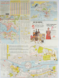
HOFFMAN, WALTER K. (CARTOGRAPHER).
A-O-A Map Sheet: Orientation Mini-maps.
Hong Kong.: Walter K. Hoffman. January/February1976. Coloured tourist map brochure of maps of Hong Kong printed both sides six maps in total folded. Brochure also includes advertisements currency rates. Minor tears along folds otherwise in good condition. Text in traditional Chinese English and Japanese. Sheet measures 58.2 x 43.4cm. Sheet includes 6 individual maps: Map of British Crown Colony of Hong Kong Map of the Urban Area with routes for public transportation Map of Tsimshatsui large scale street map Map of Central District large scale street map Map of Wanchai large scale street map Map of Causeway Bay large scale street map Map of Portuguese Overseas Province of Macau. On the maps of Central and TST the names of many businesses hotels etc are marked. . Walter K. Hoffman. unknown
Bookseller reference : 161881
|
|
|
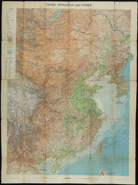
THE GEOGRAPHICAL INSTITUTE.
China Mongolia and Korea: With Boundaries Roads and Railways.
Edinburgh.: John Bartholomew & Son Ltd. 1953. Colour folding map laid down on linen. Scale 1:450000. 97 x 72 cm. Small holes and tears at some folds a little light browning. Cloth tape repair at fold adjoining upper card cover. Frederick Warne label upper cover a little creased and torn key includes glossary of Chinese geographical terms translated into English. Contour-coloured world map series. Published in the period immediately following the Korean War this map shows the 38th Parallel. . John Bartholomew & Son Ltd. hardcover
Bookseller reference : 161304
|
|
|
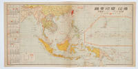
[THE ASAHI SHIMBUN]. 朝日新聞社.
佛印・蘭印要圖. 朝日カレンダー・ニユース地圖版. Futsu-In Ran-In Yozu. Asahi Karenda Nyusu Chizuban. Detailed Map of Southeast Asia. Daily Calendar News Version.
No place of publication.: 朝日新聞社. The Asahi Shimbun. 昭和十五1940. Published by 朝日新聞社 The Asahi Shimbun Japanese folding coloured WWII map with a calendar from January to June Shōwa 15 at the left scale 1:300000. Map includes French Indochina Dutch East Indies and parts of the territory of Papua China and British India. Some light browning and foxing otherwise very good. Text in Japanese. 25.3 x 51cm. Legend at lower left lists the boundaries between continents countries and provincials or regions railways airline routes capitals and Japanese embassies and consulates. <br> <br>The natural resources are indicated across the map. The map also shows parts of the territory of Papua under Australia's administration " 濠洲委任統治領 Gōshū inin tōchiryō". . 朝日新聞社. [The Asahi Shimbun]. unknown
Bookseller reference : 160545
|
|
|
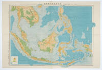
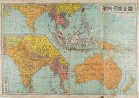
[KOYAMA, KICHIZO]. 小山吉三.
蘭領東印度諸島詳圖 附泰國・佛印・マレー半島. Ranryo Higashi-Indo Shotoo shozu : Fu Taikoku Futsu-In Mare Hanto. Malay Archipelago.
東京.Tokyo.: 日本名所圖繪社.Nihon Meisho Zuesha. 昭和16 1941. Folding colour Japanese map of the Malay Archipelago and Thailand scale 1: 8500000 with attractive original pictorial paper envelope. This map also shows the Dutch French and American colonies. Hainan Province and the South China Sea are shown in the north. Agricultural and mineral resources indicated across the map. Few small holes at holes and other light signs of wear. Slipcase lttle torn. Text in Japanese and English. 53.3 × 78.2cm. . 日本名所圖繪社.[Nihon Meisho Zuesha]. unknown
Bookseller reference : 160538
|
|
|
KOYAMA, KICHIZŌ] 小山吉三.
蘭領東印度諸島詳圖 附泰國・佛印・マレー半島. Ranryo Higashi Indo shoto shozu : Fu Taikoku Futsuin Mare hanto. Malay Archipelago.
Tokyo.: 日本名所圖繪社.Nihon Meisho Zuesha. 昭和 17 1942. Folding Japanese coloured map of the Malay Archipelago and Thailand during World War II scale 1:8500000. Legend in lower corner indicates altitudes. Ink annotation in Japanese left edge. Pin holes at three corners upper right corner torn with loss evenly browned otherwise very good. Text in Japanese and English. 52.8 x 75.6cm. This map shows most of Thailand former Indochina Hainan Province and South China Sea Sumatra and Java Sea Borneo the Philippine Islands Celebes Timor New Guinea and parts of Micronesia. Natural resources such as tobacco spices wood sugar metal mines tin iron and etc. rice and other resources are indicated on the map. . 日本名所圖繪社.[Nihon Meisho Zuesha]. unknown
Bookseller reference : 160533
|
|
|
[TOURIST MAP OF HANGZHOU].
杭州游覽图. Hangzhou you lan tu. Tourist Map of Hangzhou.
杭州.Hangzhou.: 浙江人民出版社.Zhejiang renmin chu ban she. 2nd Edition 3rd Printing. 1962. Folding colour tourist brochure for Hangzhou. One side shows large map of Hangzhou the other 5 more detailed maps chops and previous owner's annotations upper cover small hole at one fold some light wear and browning good. Text in both traditional and simplified Chinese. Sheet size 53.9 x 38.3cm folded size 13.5 x 19.2cm. <br> <br>One side includes a legend an inset showing tourist spots surrounding Hangzhou a table shows lists of Hangzhou's hospitality industry e.g. hotels cinemas swimming pools restaurants department stores etc. The other side includes five individual tourist maps: Viewing Fish at Flower Pond 花港觀魚 Lingyin Temple 靈隱 Hangzhou Bus Map 杭州市公交路线图 Lonely Mountain 孤山 Dreaming of the Tiger Spring 虎跑. . 浙江人民出版社.[Zhejiang renmin chu ban she]. unknown
Bookseller reference : 160933
|
|
|
[CELEBES AND MOLUCCA - 1943 JAPANESE MAP].
標準大東亜分図: 13 セレベス・モルッカ諸島扁. Hyōjun Dai tōa bunzu: 13 Serebesu・Morukka shotou-hen. Standard Maps of Greater East Asia: 13 - Celebes and the Moluccas.
Tokyo 東京: 統制社Tosei-sha. 昭和 Showa 18. 1943. Colour folding map 54 x 75.5cm with original envelope. Envelope a little torn some occasional browning very good. The 13th map in this Standard Maps of Greater East Asia series of 20 maps. All text in Japanese. Shows railways shipping routes administrative boundaries airfields ports lighthouses mines oil wells etc. . 統制社(Tosei-sha) unknown
Bookseller reference : 160554
|
|
|
[SHIHAN GAKKŌ] 師範学校編輯.
北亜米利加洲. Kita Amerika-shū. The States of North America.
Kyoto.: 村上勘兵衛 文部省刊行. Murakami Kanbē; Monbushō kankō. Meiji 10 1877. Colour woodblock map of North and Central America. From the Journal of World Geography 萬國地誌略 published in 1877. Printed area measures 33.5 x 21cm a good copy with occasional soiling. . 村上勘兵衛, 文部省刊行. [Murakami Kanbē; Monbushō kanko& unknown
Bookseller reference : 159812
|
|
|
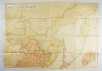
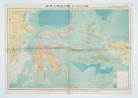
[MATSUKI, TAMANOSUKE]. 松木玉之助.
濠州・印度全圖. Gōshū Indo Zenzu. Complete Map of Australia and India.
東京.Tokyo.: 金鈴社. Kinrei-sha. 昭和十八 October 101943. Two maps printed in colour on a single side of a folded sheet. The map titled "Complete Map of India and Australia" shows the region covering Australia southern India western mainland south-east Asia Indonesia the Philippines and New Guinea. The other map titled "India and Burma" shows the region covering India Afghanistan the western section of China Burma and Thailand on the lower left side. New Zealand is in an inset map in the lower right corner. As the note on the cover says "Including the detailed descriptions of the Solomons New Guinea and southern islands" this map shows the theatres of the Pacific War and the surrounding areas. The map indicates agricultural and mineral resources as well as cities roads railways sea routes national borders etc. Cover and publication details printed on two panels on the reverse. Some marking and browning. . 金鈴社. [Kinrei-sha]. unknown
Bookseller reference : 159290
|
|
|
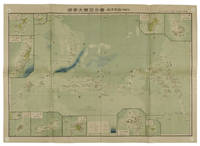
[SERIZAWA KEIGO]. 芹澤馨吾
標準大東亞分圖・南洋群島 内南洋. Hyojun Daito-A bunzu: Nanyo gunto nai Nanyo. Standard Sectional Map of the Greater East Asia: the South Sea Islands Inner South Sea.
統正社 Tōseisha . Showa 18 1943. Colour folded map 54. x 76.5cm. Pinholes at corners light even browning good copy. This Japanese map of Micronesia shows the Mariana Islands Eastern and Western Caroline Islands Marshall Islands and Gilbert Islands. The separate maps around the edge are clockwise from the upper right corner: Jaluit Atoll Guam Island Rota Island Saipan Island Palau Islands Yap Island Hall Islands Pohnpei Island Truk Islands and Kusaie Island. . 統正社 [Tōseisha ]. unknown
Bookseller reference : 155215
|
|
 Receive by email
 Download as PDF document
 RSS feed


