Sanson, Jerry PurvisBiblio.com

1 001 résultats
réf. 0807172774.Gpaperback. Good. Access codes and supplements are not guaranteed with used items. May be an ex-library book. paperback
réf. GTC3777Texas Parks and Wildlife Press. Signed by both Sanson and Meinzer 1st ed.; fine condition DJ fine condition. Texas Parks and Wildlife Press unknown
réf. 45001475-nnew. unknown
réf. 45381529-nnew. unknown
réf. 46662661-nnew. unknown
réf. 0972123369.Gperfect. Good. Access codes and supplements are not guaranteed with used items. May be an ex-library book. unknown
1983réf. BN255751München : Beck Verlag 1983. 1983. Tagebücher der Henker von Paris : 1685 - 1847. - 2 Bände komplett Hrsg. von Eberhard Wesemann u. Knut-Hannes Wettig Bibliothek des 18. Jahrhunderts Tagebücher der Henker von Paris : 1685 - 1847. - 2 Bände komplett Hrsg. von Eberhard Wesemann u. Knut-Hannes Wettig Bibliothek des 18. Jahrhunderts Henri Sanson München : Beck Verlag unknown
réf. 45381745-nnew. unknown
1656réf. 006682Paris: Chez l'Autheur 1656. First Edition. Full Calf. Very Good. 4to. 23.5 by 17.5 cm. Unpaginated 100 pages of text plus 2 pp. of ads. With 18 copper engraved maps all two page plates each with hand-colored of boundaries. Maps include one of the entire continent then of its various regions as then known plus the islands off the continent. Also a map of Malta. Bound in contemporary calf. Condition: calf dry and rubbed on spine and joints and edges rubbed. Light to moderate soiling in the margins of the pages. Two bookplates -- one of the Marquis of Lothian the other the Newbattle Abbey Library. Chez l'Autheur unknown
1652réf. 006683Paris: Chez l'Autheur 1652. First Edition. Full Calf. Very Good. 4to. 23.5 by 17.5 cm. Unpaginated 102 pages of text plus 2 pp. of ads 1 Royal privilege page. With 17 copper engraved maps all two page plates each with hand-colored of boundaries. Maps include one of the entire continent then of its various regions as then known plus island groups. Separate maps for China and Japan. Bound in contemporary calf. Condition: Rebacked with joints making this obvious. The original spine was re-mounted with some losses. Its blindstamped decoration of fans is discernible but somewhat vague. We think it is possible this decoration had some gilding or color originally but none survives. Still an interesting and unusual feature in our view. Calf dry and rubbed on spine and joints and edges rubbed. Light to moderate soiling in the margins of many pages and on a few pages the soiling invades inward beyond the margins and also in a few instances the marginal soiling is on the heavier side. There are a few archival tape repairs of small chips three on the title leaf one on the following leaf and after that wormhole edge damage was left untouched. That said the defect and repair isn't as glaring as it might sound. The edges elsewhere can have short spans of a chewed appearance. As a book generally we would consider this copy at best Good. As far as the maps go independent of the book we would regard them as Very Good. A few of the maps might individually fall short of such grading; on the other hand all the maps of this copy one can easily imagine someone enthusiastically framing even without an attempt to clean them up. Two bookplates -- one of the Marquis of Lothian the other the Newbattle Abbey Library. Chez l'Autheur unknown
1656réf. 76600Paris 1656. 4to. Samtidig mykt helpergamentbind. 100 s. 2 s. annonser. Med 18 dobbeltsidige grensekolorerte kart. 4to. Contemporary limp vellum. Unpaginated. 100 pp. In addition two pages of advertisements. 18 engraved double page maps. Boundaries coloured. Chez l’Autheur. Fransk. Noen få sider med små rifter affiserer ikke teksten eller kartene. Noe gulnet i ytterkantene.A few pages with small tears not affecting text nor maps. Some browning to extremities. Nicolas Sanson d’Abbeville 1600-1667 “considered by many to be the founder of the French school of cartography” Tooley. hardcover
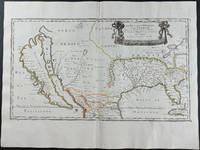
1656réf. 9429Engraving outlined in original color in the third state with Chez l'Autheur to the cartouche. Sanson's first large format regional map of North America depicting California as an island. The map measures approximately 21.5 x 12.5 in 54.5 x 32 cm with the paper size being 23.5 x 17.75 in 60 x 45 cm. Scarce.
2021réf. Gyan-9789333378413Facsimile Publisher 2021. Hardcover. New. 22.59 x 14.34 x 3.46 cm. English Facsimile Publisher hardcover
2021réf. Gyan-9789333378413Facsimile Publisher 2021. Hardcover. New. 22.59 x 14.34 x 3.46 cm. English Facsimile Publisher hardcover
réf. 2-24828Bruxelles Librairie Médicale de J.-B. Tircher 1834 due volumi in-8vo cartonato coevo pp. VIII-562 556 due frontespizi con incisione zilografica con motto ciascno con timbretto in ceralacca con le iniziali V.C. Piccolo strappo al dorso del primo volume. unknown
2004réf. H-405-5902004. Paperback. Good. Former library book. Different cover. Different publisher. Ammareal gives back up to 15% of this item's net price to charity organizations. paperback
2005réf. X-343-635STE ECRIVAINS 2005. Paperback. Good. Former library book. Different cover. Ammareal gives back up to 15% of this item's net price to charity organizations. STE ECRIVAINS paperback
2003réf. 2-2868478255PU Rennes 2003. Paperback. New. 562 pages. French language. 9.37x6.30x1.42 inches. PU Rennes paperback
réf. 17757London: J. Hooke at the Flower-de-Luce in Fleet Street & 2 others 1720. title continued: Being a Collection of Letters That passed between an English Lady and an English Gentleman in France who took an affection to each other by reading accidentally one another's Occasional Compositions both in Prose and Verse.First edtion First Issue. Engraved head and tail pieces. 8vo 7 3/4 x 4 3/4 inches pages: xxiv Dedication to Sir Richard Steele:xxv-lxviii A Critical Essay.by way of Letter from Mr. John Porter.:131 contemporary full panelled tan calf 20th Century very neat reback in tan calf with lettering piece. Contemporary signature 'Nichs Marshall' on front fly. Anon. Rare. Clio was Fowke's "literary" name for herself while Strephon was the poet and journalist William Bond. The work is an exchange of letters in verse and prose. Fowke's poetry sometimes expresses her frustration with the conventional expectations of a woman's place in 18th Century society; her former friend and fellow-writer Eliza Haywood attacked Fowke in a scandalous account of her relationships which affected the poet's reputation badly. London: J. Hooke, at the Flower-de-Luce, in Fleet Street [& 2 others], 1720. unknown
1678réf. 200041AG1678. Paris Sanson d'Abbeville 1678. Original hand-coloured engraving. Plate Size: 53.6 cm x 41.7 cm. Sheet Size: 61.8 cm x 46.5 cm. Original map. In very good condition. Faint signs of browning to map. Minor paper imperfections to the outer margins. Small stain to map near centre-fold. A richly detailed map showing the northern part of Portugal. Relief on map depicted pictorially and border inlaid with longitudinal and latitudinal details The map is dominated by three rivers: the Tajo Tagus in the south the Douro and the Minho further north. The Spanish kingdom and regions such as Leon are included and the great city of Salamanca can be seen. The lower part of the map runs out before the Tagus estuary empties into the Atlantic at Lisbon. The ornamental title cartouche is in the lower right corner of the map. Off the coast is a large warship flying the coat-of-arms Kingdom of Portugal and the Algarves. The sails of the boat carry Latin text commemorates the commercial and maritime exploits of King John IV in Africa Arabia Ethiopia Persia India and Brazil. Nicolas Sanson 20 December 1600 7 July 1667 was a French cartographer termed by some the creator of French geography in which he's been called the "father of French cartography." The French school of Geography was unprecedented in its attention to precision and scientific detail and discarded much of the decorative embellishments of previous maps as irrelevant. From Sanson's time in the second half of the seventeenth century until the latter part of the eighteenth century French geographical conceptions were more influential than those put forward by any other nation. He was tutor to Louis XIII and Louis XIV. Sanson published over 300 maps. In 1692 Hubert Jaillot collected Sanson's maps in an Atlas nouveau. Wikipedia unknown
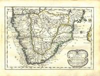
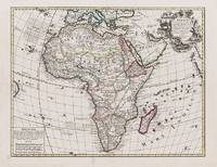
1595réf. 100047AG1595. Paris / London / Antwerp and other places of print c.1595 - 1851. Some stunning examples of hand-coloured copper-engravings plus one manuscript map Tuckey / Congo - Zaire. All of these maps in very good / excellent condition. This collection presents itself for becoming an amazing a meaningful starting-point for an Africana-Collection decoration for a Safari-Lodge interior-design for an Africana-themed library etc. etc. The price includes worldwide free shipping per DHL Express-Courier 2-3 day-delivery. Ask for complete list and images and please also inquire about our amazing book-collection of Africana which would be a great match for this collection of vintage maps. unknown
réf. 14357382like new. unknown
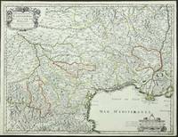
réf. 3863Paris: P. Mariette. 1651. No binding. Good. 420 x 550 mm. early outline colour. One small paper crease upper margin otherwise a superb example. Engraved by R. Cordier this fine map displays the region of Languedoc in south western France extending from the Pyranees to the Rhone valley. Inland to the north west the cities of Toulouse and Cahors are displayed. From the 'Cartes Generales de Toutes les Parties du Monde'. Pastoureau Sanson V A no. 44. P. Mariette. 1651 unknown
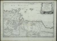
réf. 3952Paris: 1655. No binding. Very Good. 370 x 530 mm. in early outline colour in very good condition. Engraved by Joannes Somer and published in Paris by Pierre Mariette this attractive map of central north Africa bears an ornate title cartouche top right. It is centred on Tunisia and Libya and includes the island of Malta in the Mediterranean. It comes from Sanson's 'Cartes Generales de Toutes les Parties du Monde'. Pastoureau Sanson V A no. 16. 1655 unknown
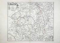
réf. 5579Paris: 1658-79. No binding. Very Good. 370 x 440 mm. early outline colour in good condition. This map of the Champagne and Brie region of France was published in Paris by Pierre Mariette. It appears in the first edition of Nicolas Sanson's ""Les Cartes Generales"" in 1658. Sanson was France's premier cartographer and helped to lift French work in this area to another level. His atlas is the first full world atlas to be produced in France. This work had been in development for several years as the dates on the various maps attest. Pastoureau 1984 Sanson Va no. 11; Phillips P.L. 1909- 4260 no. 11. 1658-[79] unknown