2 133 résultats
1958Very Good English Revised Third Edition of this rare map of Cyprus, made by Salmon, who was the director of Cypriot land registration and surveys. "Shows grid, district boundaries, heights in feet, railways, roads (2 categories), antiquities, ancient sites.". / "Shows district boundaries, towns and cities, roads (2 categories), railroads, ancient sites and antiquities, and dry streams. Relief is shown by contours, gradient tints, and spot heights. Earlier Edition: 1952.". (OCLC). "In December 1926, in a memorandum to the Colonial Office on vacant surveying positions in the colonies, Palestine and Cyprus were mentioned at the end of a group of Mediterranean colonies; that is there was a group of Mediterranean colonies, and also Cyprus and Palestine [.] Only in 1929 was an Imperial project involving Palestine and Transjordan, brought up at the committee (Colonial Survey Committee). This was the experimental aerial survey for determining the route of the Haifa - Damascus railway, which was presented as a model for mapping from aerial photographs [.] Among the important things reported to the Colonial Survey Committee was the reconnaissance conducted by Colonial Winterbotham, the Chief of the GSGS, in the survey departments of the colonies in 1929, a trip that had been encouraged in the first Conference of Empire Survey Officers in 1928 [.] ... how much Salmon [F. J.] expected from Winterbotham's visit to Ceylon a short time before he was to take over the directorship of the small survey department of Cyprus.". (Source: The Survey of Palestine Under the British Mandate, 1920-1948). Original color map. Folded in original wrappers. Fine. Elephant folio. (58 x 89 cm). In English. Survey of Cyprus administration map. Scale of 4 miles to one inch = 1/253440. Compiled and drawn under the direction of F. J. SALMON, (Director of Land Registration and Surveys, Cyprus, 1932). Revised Third Edition. Second in 1950.
1968Very Good Turkish Paperback. Folio. (34 x 24 cm). In Turkish. 2 volumes set: (70 p.; 64 p.). Eldem was a Turkish architect and one of the pioneers of nationalized modern architecture in Turkey. He was born in Istanbul (1908). He graduated from the Academy of Fine Arts (Department of Architecture). Between 1931 and 1932 he traveled to France, England, and Germany with a scholarship from the academy. In 1932 he opened his own office, also started teaching at the Academy of Fine Arts, and continued until retirement in 1978. In 1934 he worked for the National Architecture Seminar in Turkey which was a complete disaster for him because of the discussions between modern architecture and traditional architecture. In 1938 he designed the Turkish Pavilion in New York Exhibition. Sedad Hakki Eldem represented the Turkish Republic at the International Union of Architects in Lozan (1948) after Second World War. Also in the same year, Sedad Hakki worked with his colleague Emin Onat on the project of Istanbul Palace of Justice. He worked on proportions and architectural organizations of Ottoman domestic houses, 18th and 19th-century palaces, and mansions. He was known as a role model and pioneer to reinterpret the Classical Ottoman Patterns in modern architecture. He was a part of the Former Artifacts Maintain Council (Eski Eserleri Muhafaza Encümeni) between 1941 and 1945 and also a part of the Supreme Council of Antiquities and Monument Real Estate (Gayrimenkul Eski Eserler ve Anitlar Yüksek Kurulu) between 1962 and 1978. His thought was about nationalizing Modern Architecture. He basically thought that International Style in architecture should not be applied everywhere. Some things should be changed in the design by considering the national and domestic texture. He has won the international Aga Khan Award for Architecture in 1986 with the project of Zeyrek Social Security Facilities. Sedad Hakki Eldem's architecture has basically 4 main periods. The first of them, between 1928 and 1934, is known for the instability of his work. After that, the second period is popular with modern trials on Ottoman architectural organization. The time frame of this period spans from 1934 until 1952. The third period of his architecture has lost its Ottoman influence, it looks more modernized between 1952 and 1962. The last part of Eldem's Architecture known for his double approach to projects. This final period started in 1962 and lasted until his death in 1988. (Wikipedia).
1930Very Good Turkish, Ottoman (1500-1928) Original pictorial wrappers. Chromo-lithographed photo-montage collage cover with seven b/w photos of African buildings and natives, and a red map of Africa. Complete in wrappers and folded huge Africa map (size: 57 x 82 cm). Cover size: 28.5 x 20.5 cm. In Turkish. Scale: 1/20,000,000. A very rare chromo-lithographed Africa map, prepared for the geography lessons about foreign countries in Turkey in 1930. The map shows the territories of the African continent, which was still politically under European colonialism as of the 1930s. It includes Rio de Oro (Spanish territory), Fas [i.e. Morocco], Algeria, Sahara, Cameroon (French territories), Trabulus [i.e. Libya] as Italian territory; and Liberia, Egypt, East Sudan, Eritre [i.e. Eritrea], Habesistan [i.e. Ethiopia], Somali, Kenya, Belgian Kongo, Angola, Mozambique and South African land including Rhodesia (equivalent in the territory to modern Zimbabwe), Transvaal, The Orange Free State [Oranje-Vrystaat], Natal and Kap [Cape] with Madagascar. An extra panel for the same scale map showing the Suez Canal, Nile Delta, and North Egypt in the lower-left corner. Duran studied in Istanbul and Paris. He worked as a geography teacher in various high schools and afterward he undertook the positions of lecturer and administrator in Ankara Gazi Education Institute for a time. He was known for his writings on various topics and particularly for his works on geography. Born in the imperial period, Duran conducted the first cartographic studies of the Republic of Turkey after the transition to the Republican administration. Sealed. Slight foxing. Otherwise a fine copy. Not in OCLC.
1921Very Good Turkish, Ottoman (1500-1928) An extremely rare litho propaganda map published as an extra supplement to the Tercümân-i Hakîkat [i.e. The Translator of Truth] newspaper just before the proclamation of Republic in Turkey in 1923 by Mustafa Kemal Atatürk (1881-1938), showing the front in West Anatolia during the War of Independence (or National Struggle) between 1919-1922 against Greek forces. The upside of the map between the note as title 'Gift to the readers of 'Tercümân-i Hakîkat', Mustafa Kemal Atatürk's portrait among decorated heroic lithographed drawings. In the lower right corner, can be seen legends of the map, scale, and mapmaker's signature. Tercümân-i Hakîkat was a daily newspaper published in Istanbul between 1878-1921 during the Ottoman Empire. Tercüman-i Hakîkat, the most important newspaper published during the reign of Sultan Abdülhamid II, was founded by novelist Ahmed Midhat Efendi, (1844-1912). In the beginning, most of the articles were written by Ahmed Midhat Efendi. It was an encyclopedic newspaper with the aim of inculcating and educating reading habits among the Turks and it played an important role in the training of many famous Ottoman journalists. Its first issue was published on June 26, 1878. After Ahmed Midhat's death in 1913, the newspaper changed owners, and the last issue was published on February 11, 1921. Ibrahim Alaettin Gövsa, (1889-1949), was an Ottoman / Turkish journalist, educator, and intellectual who supported the War of Independence the most. This propaganda map published in Tercümân-i Hakîkat, during the war in 1920 or 1921, is a propaganda tool that calls on the literate people belonging to a certain class, especially those living in Istanbul, to support the war, and aims to spread the word that Turkey is winning the war. Original lithograph map. 50x35,5 cm. In Ottoman script (Turkish with Arabic letters). Scale: 1: 250.000. Occasionally foxing and slight stains on paper, folded traces. Otherwise a very good copy.
1923Very Good English Original b/w portolan chart. Folded. A little foxing and some pencil markings and notes in Ottoman script in its period. Oblong double elephant folio. (70 x 102 cm). In English. Bosphorus to Kerempeh from the Russian survey of 1834 with additions and corrections by Commander W. J. L. Wharton., R. N. 1872-80. It's written 'London published according to Act of Parliament at the Hydrographic Office of the Admiralty Jare. 16th 1854. Also shows Killa Bay (Shile Bay) from a survey by Lieut. Comm. W. R. Pristen and the midshipmen of H. M. S. Royal Sovereign, 1920. Topography partly from a Turkish map. Up side of map, engraved a view from sea of entrance of the Bosphorus, Rumili (sic. Rumeli) Lighthouse and environment with several hills. And also shows Amastra (Ancient Amastris) from Russian surveys, 1834-41; Kosku Bay from a surbey by Capt. Spratt R. N. 1854; and Sungul Bay (Zonguldak) from the Heraclee Companys plans to 1915. A rare navigation chart.
1915Very Good Turkish, Ottoman (1500-1928) Modern cloth bdg. Small 4to. (26 x 19 cm). In Ottoman script (Old Turkish with Arabic letters). 24 p. First edition of this epic and historically important account, describing the siege and fall of the Byzantine Empire and Constantinople by Ottoman Sultan Mehmet II in 1453. This is one of the finest literary examples of sixteenth-century Ottoman prose. "This description of the conquest of Istanbul in 1453 is mentioned only by Ismail Pasha in his "Hediyyetü'l Arifîn". The text, which was published as a supplement to TOEM (parts 20 and 21, Istanbul 1331) is said to be taken from a manuscript owned by Halis Efendi. The introduction to Ca'fer Çelebi's life was also written by Halis Efendi. The work is written in a very elegant style, with ayets, hadith, and beyts in Arabic, Persian, and Turkish scattered throughout the text and may be considered one of the finest examples of sixteenth-century Ottoman prose writing. [.] Ca'fer's work is in some aspects a reliable source for the conquest of Istanbul. The preparation for the siege is given in this work. The council of war which was held before the siege and in particular Mehmed II's speech to the council is very detailed and the chain placed across the entrance to the Golden Horn and its history is very well described in this work as well. During the siege, the Byzantines received help from the outside. Ca'fer is specific about this and states that "four huge vessels full of provisions, soldiers and ammunition came to help of the Byzantines". After the last attack, Constantinople fell into the hands of the Ottoman army. The date given for this is 857 Cem. I. 20 Seshenbe in Ca'fer's work. The plundering and looting which occurred during the first three days of the conquest are vividly described by Ca'fer Çelebi, but the withdrawal of Justinian and his men which preceded the conquest and the death of the Byzantine Emperor during the capture of the city are omitted in this work. Ca'fer's closing lines are devoted to the conversion of St. Sophia (Ayasofya) into a mosque by Mehmed II. Ca'fer Çelebi used eyewitness accounts as well as written works. It is certain that he did not rely exclusively on any source which is not extant, for the departs from Ruhi, Enverî, Tursun Beg, Neshrî, and Asikpasha-zâde either by adding new information or giving a conflicting account." (Erünsal). Özege 11953; TBTK 7066.
1910Very Good Turkish, Ottoman (1500-1928) Original color litographed plate. 18x41 cm. In Ottoman script (Turkish with Arabic letters). Two-paged plate. A rare color lithographed plate from Mehmed Esref's 'Muhtasar Umûmî Atlas'. A very detailed plate showing Europe's and the US' demographic structure in 1922 with very attractive detailed statistical schemes. Besides the usual demographic scheme, there are 28 European states on the plate: Germany, France, Spain, Russia (Soviets), England, Italy, Poland, Romania, Holland, Norway, Estonia, Czechoslovakia, Austria, Switzerland, Lithuania, Yugoslavia, Portugal, The United States of America, Hungary, Sweden, Denmark, Latvia, Belgium, Greece, Finland, Avrupa-yi Türkî [i.e. Turkey in Europe], Albania. Mehmed Esref (1846-1912) was a Turkish / Ottoman military cartographer and educator in the Ottoman military school [Mekteb-i Harbiye] active in the first part of the 20th century, and he prepared and published many separate maps and atlases more besides this one.
1926Very Good Turkish, Ottoman (1500-1928) Original map of Kars Fortress. Oblong: 45x57 cm. In Ottoman script. Scale: 1/21000. [PLAN OF KARS FORTRESS] Kars Kal'asi plâni (Based on 1898 discoveries and 1908 practice). A very detailed plan in Ottoman script of Kars Fortress and is environment. Some red markings. Extremely rare.
1890Very Good French Original albumen print photograph by Sebah & Joaillier mounted on cardboard. Size: 25,5x33 cm; photographic size: 21,5x26 cm. Rare albumen print photographs double-sided printed mounted on green cardboard taken by Sebah & Joaillier photograph studio of Constantinople, showing the Bosphorus, view of Therapia Bay and Pier with the Asian and European coasts of the strait. In 1857 photographer Pascal J. Sébah opened a studio in Constantinople, today Istanbul, Turkey. Photographing city views, daily activities, and ancient ruins in the surrounding area, Sébah sold many of his prints to visiting tourists, a prosperous and common market for other contemporary photographers, such as the well-known Abdullah Frères. Tourists would select a range of prints from professional photo studies in the countries they visited and compile a travel album of their journey. In 1888, two years after Pascal J. Sébah passed away, his 16-year old son Jean (Johannes) became involved in the studio work. Jean started a partnership with another photographer from Istanbul, the Frenchman Policarpe Joaillier, which became a great success. Jean worked both on assignments for the studio and as an individual photographer, which can be determined from the signatures on the works: some prints were signed "Sébah & Joaillier," others have the signature "J.P. Sébah" The studio flourished and Sébah & Joaillier were named as the official photographers of the Ottoman Empire by the Turkish sultan. In the early 1900s Joaillier returned to Paris and Sébah continued his work in Constantinople. After different partnerships, the studio was taken over by Ismail Insel and renamed "Foto Sabah" [i.e. Photo Morning].
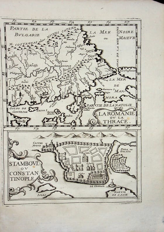
réf. 018796[Philippe Briet, Parallela geographiae veteris et novae] La Romanie ou la Thrace - Stamboul ou Constantinople - Grèce et Turquie. Gravure originale, 1649, environ 240*170mm. Gravure tirée de l'ouvrage du savant jésuite Philippe Briet (1601-1668) publié en 1648-1649. Texte au dos. [436]
1885Very Good English Fine and attractive original panoramic photograph of Constantinople, Istanbul, printing-out paper, 4-part, buildings captioned and credits in negatives in French. 70x9 cm. A dark print. This panoramic photograph was taken by Gülmez Freres inside Robert College. Robert College was founded in Bebek by Christopher Robert, a wealthy American philanthropist, and Cyrus Hamlin, a missionary devoted to education in 1863. The Gülmez Frères were three brothers, of Armenian origin, who established a photography studio in Istanbul, Turkey in 1870. A short time later, they took photos for the Ottoman court and Sultan Abdulhamid II.
2009New English Paperback. Pbo. 4to. (29 x 24 cm). In English and Turkish. 64 p., color ills. [Painter's Istanbul].= Ressamlarin Istanbul'u. 18 Mart - 11 Nisan 2009. [Exhibition catalogue]. 1000 copies were printed.
2004Fine Greek, Modern (post 1453) Paperback. Small. 4to. (26 x 20 cm). In Greek. 171, [2] p., color and b/w ills. [Our trial of Cappadocia. A wandering pilgrimage]. E dikia mas Kappadokia. Ena odoiporiko proskunema. Signed and inscribed by Kekes.
1894Very Good Turkish, Ottoman (1500-1928) Original color chromo-lithograph map. Folded. Oblong folio. (40 x 50 cm). In Ottoman script. Color lithograph. It Portugal and Spain with Gibraltar and North African shores. Scale: 1:3.500.000. Dated Hegira: 1310 = [Gregorian 1894]. OTTOMAN MAP of SPAIN & PORTUGAL] Ispanya & Portekiz: Sâye-i Türkiye Hazret Gazi Sultan Abdülhamid Hân-i Sâni'de Maarif Umûmiye Nezâret-i Celîlesi ruhsatiyle Haset tarafindan Fransa Cemiyet-i Cografya âzâlarindan mütesekkil komisyona mahsûs tanzîm edilmis oldugu son atlasinin tercümesi olarak bu def'a Erkân-i Umûmiyye Dairesi Besinci Fen Subesi'ne me'mûr piyade mirlivâlarindan saâdetlü Ali Seref Pasa maarifetleriyle tersîm ettirilmistir. This uncommon map of Spain and Portugal in Ottoman script was published in an atlas, 'Yeni cografya atlasi', which was issued in Istanbul in the late 19th century. Ali Seref Pasa or Hafix Ali Esref. He was a soldier, who was schooled in Paris as a cartographer around 1862. Already in Paris he published his first atlas with 22 maps, called 'Yeni atlas'. Upon his return to Istanbul he became a chief cartographer at the Maatbaa-i amire Printing Press in Beyazit, which was the successor of the Muteferrika press from 1727. Among others he translated the large Kiepert map of Anatolia to Ottoman. He died in 1907, leaving his large project of a gigantic map of Anatolia in 100 sheets unfinished. Ali's name is often misunderstood or even listed as two different people: Ali Seref Pasa and Hafiz Ali Esref. Until the surname law adopted on June 21, 1934, Turks did not have surnames. They were born with one first name and were until the adulthood described only as sons or daughters of their parent's names. Later they were given titles such as Effendi (Sir), Bey (Chief) or Hanim (Madam) for higher classes, or they were given names according to their work or class. The names were not inherited by children until 1934, when the surname law was enforced. The map maker Ali received names Seref, the honourable, and Pasa, the dignitary. He was also known as Hafiz, the memorizer of Qur'an and Esref, Proud. So Ali Seref Pasa would have a meaning 'Honourable Dignitary Ali, and Hafiz Ali Esref, Memorizer of Qur'an, Proud Ali. Daruttibaa - Matbaa-I Amire Printing Press: The first press in the Muslim world, called Daruttibaa, was founded in Istanbul by Ibrahim Muteferrika in 1727, with a permission of Sultan Ahmeet III. It was located in Muteferrika's house. The first book was published in 1729 and until 1742 sixteen other works followed. After Muteferrika's death, the press was supressed for printing, as printed books were considered dangerous. In 1796 the press was purchased by the government and moved to Uskudar in Istanbul, and in 1831 finally to Beyazit, where it was renamed to Matbaa-i Amire in 1866. The press was closed in 1901 and was reopened in 1908 under the name 'Âmire' In 1927 the name changed to State Printing House. The press still exists and is known for publishing school and educational books. Extremely rare. Not in OCLC.; Not in TBMM Map Collection.
Very Good Turkish, Ottoman (1500-1928) Original color map from an early 20th century Turkish atlas. Oblong folio. (25 x 35 cm). In Ottoman script. No scale. Shows South Iran with Lake Urmia at north and Iraq border at west. Toponyms are mostly in old Turkish. [OTTOMAN MAP of SOUTH IRAN and IRAQ] Simâlî Irak ve Iran haritasi.
1916Very Good Turkish, Ottoman (1500-1928) Original color map. Folded. Oblong atlas folio. (50 x 60 cm). In Ottoman script. Shows Rhodes and Tilos Islands. Scale: 1/200.000. Hegira: 1332 = Gregorian: 1916. Not description on map-maker. This is one of the series of the Bonn projection maps which are the first map series in modern techniques in Turkey and the Ottoman Empire. This is one of the series of the Bonn projection maps which are the first map series in modern techniques in Turkey and the Ottoman Empire. In order to produce these maps covering Turkish territory, Reconnaissance Branch was incorporated into The Mapping Commission. The maps were produced in the datum based on the latitude and longitude of Ayasofya Mosque in an equal area Bonn Projection. The field works for the 123 sheets covering the country were conducted by 76 staff. The production was completed in 18 years starting from east-west. Fieldworks continued without stopping except in the years 1914 and 1920. This map series called also reconnaissance maps contributed a lot to producing 1:25.000 scale maps. A very detailed and attractive map of Rhodes Island showing its harbors and Ottoman place names.
1916Very Good Turkish, Ottoman (1500-1928) Original color map. Oblong atlas folio. (51 x 61 cm). In Ottoman script. Folded. Topography and toponyms of East Anatolia: Shows Erzurum region, Hasankale (Pasinler), Oltu, Hinis, Karakilise and surroundings. Scale: 1: 200.000. This is one the serie of the Bonn projection maps which are the first map series in modern techniques in Turkey and the Ottoman Empire. In order to produce these maps covering Turkish territory, Reconnaissance Branch was incorporated into The Mapping Commission. The maps were produced in the datum based on the latitude and longitude of Ayasofya Mosque in equal area Bonn Projection. The field works for the 123 sheets covering the country were conducted by 76 staff. The production was completed in 18 years starting from east west. Field works continued without stopping except in years 1914 and 1920. This map series called also reconnaissance maps contributed a lot to producing 1:25.000 scale maps. Rare.
1894Very Good Turkish, Ottoman (1500-1928) Original color map. Folded. Oblong folio. (35 x 52 cm). In Ottoman script. Color lithograph. It shows Sudan and West Africa, Atlas Ocean shores, Sahra Desert, and other parts of Africa. Scale: 1:15.000.000. A very detailed and attractive map. Slightly fading. Otherwise a very good copy. Dated Hegira: 1310 = [Gregorian 1894]. [EARLY OTTOMAN MAP of SUDAN] Sudan. Sâye-i Türkiye Hazret Gazi Sultan Abdülhamid Hân-i Sâni'de Maarif Umûmiye Nezâret-i Celîlesi ruhsatiyle meshur Haset tarafindan Fransa Cemiyet-i Cografya âzâlarindan mütesekkil komisyona mahsûs tanzîm edilmis oldugu son defaki atlasinin tercümesi olarak bu def'a Erkân-i Umûmiyye Dairesi Besinci Fen Subesi'ne me'mûr piyade mirlivâlarindan saâdetlü Ali Seref Pasa ve rifatlubinbasi fütûvvetlü Muhyiddin Efendi maarifetleriyle tertib ettirilmistir. Ali Seref Pasa or Hafix Ali Esref. He was a soldier, who was schooled in Paris as a cartographer around 1862. Already in Paris he published his first atlas with 22 maps, called 'Yeni atlas'. Upon his return to Istanbul he became a chief cartographer at the Maatbaa-i amire Printing Press in Beyazit, which was the successor of the Muteferrika press from 1727. Among others he translated the large Kiepert map of Anatolia to Ottoman. He died in 1907, leaving his large project of a gigantic map of Anatolia in 100 sheets unfinished. Ali's name is often misunderstood or even listed as two different people: Ali Seref Pasa and Hafiz Ali Esref. Until the surname law adopted on June 21, 1934, Turks did not have surnames. They were born with one first name and were until the adulthood described only as sons or daughters of their parent's names. Later they were given titles such as Effendi (Sir), Bey (Chief) or Hanim (Madam) for higher classes, or they were given names according to their work or class. The names were not inherited by children until 1934, when the surname law was enforced. The map maker Ali received names Seref, the honourable, and Pasa, the dignitary. He was also known as Hafiz, the memorizer of Qur'an and Esref, Proud. So Ali Seref Pasa would have a meaning 'Honourable Dignitary Ali, and Hafiz Ali Esref, Memorizer of Qur'an, Proud Ali. Daruttibaa - Matbaa-I Amire Printing Press: The first press in the Muslim world, called Daruttibaa, was founded in Istanbul by Ibrahim Muteferrika in 1727, with a permission of Sultan Ahmeet III. It was located in Muteferrika's house. The first book was published in 1729 and until 1742 sixteen other works followed. After Muteferrika's death, the press was supressed for printing, as printed books were considered dangerous. In 1796 the press was purchased by the government and moved to Uskudar in Istanbul, and in 1831 finally to Beyazit, where it was renamed to Matbaa-i Amire in 1866. The press was closed in 1901 and was reopened in 1908 under the name 'Âmire' In 1927 the name changed to State Printing House. The press still exists and is known for publishing school and educational books. Extremely rare. Not in OCLC.; Not in TBMM Map Collection.
1920Very Good Turkish, Ottoman (1500-1928) Original color map on cloth. Oblong atlas folio. (44 x 58 cm). Scale: 1/200.000. Toponyms in Ottoman script /Turkish with Arabic letters). Shows southwest of the Gallipoli Peninsula [and the Hellespont], Edremid Gulf, Tenedos, and North Aegean shores of Anatolia]. Folded. This is one of the series of the Bonn projection maps which are the first map series in modern techniques in Turkey and the Ottoman Empire. In order to produce these maps covering Turkish territory, Reconnaissance Branch was incorporated into The Mapping Commission. The maps were produced in the datum based on the latitude and longitude of the Ayasofya Mosque in equal area Bonn Projection. The field works for the 123 sheets covering the country were conducted by 76 staff. The production was completed in 18 years starting from east-west. Fieldworks continued without stopping except in the years 1914 and 1920. This map series called also reconnaissance maps contributed a lot to producing 1:25.000 scale maps. Hegira: 1336 = Gregorian: 1920. Not description on map-maker. Extremely rare.
1894Very Good Turkish, Ottoman (1500-1928) Original color chromo-lithograph map. Folded. Oblong folio. (40 x 50 cm). In Ottoman script. Color lithograph. An attractive map which shows Austria-Hungary land with Venice Bay and North Italy. Scale: 1:3.500.000. Dated Hegira: 1310 = [Gregorian 1894]. This uncommon map of Austria-Hungary in Ottoman script was published in an atlas, 'Yeni cografya atlasi', which was issued in Istanbul in the late 19th century. Ali Seref Pasa or Hafiz Ali Esref. He was a soldier, who was schooled in Paris as a cartographer around 1862. Already in Paris, he published his first atlas with 22 maps, called 'Yeni atlas'. Upon his return to Istanbul, he became a chief cartographer at the Matbaa-i Amire Printing Press in Beyazit, which was the successor of the Muteferrika press from 1727. Among others, he translated the large Kiepert map of Anatolia to Ottoman. He died in 1907, leaving his large project of a gigantic map of Anatolia in 100 sheets unfinished. Ali's name is often misunderstood or even listed as two different people: Ali Seref Pasa and Hafiz Ali Esref. Until the surname law adopted on June 21, 1934, Turks did not have surnames. They were born with one first name and were until adulthood described only as sons or daughters of their parent's names. Later they were given titles such as Effendi (Sir), Bey (Chief), or Hanim (Madam) for higher classes, or they were given names according to their work or class. The names were not inherited by children until 1934 when the surname law was enforced. The mapmaker Ali received names Seref, the honorable, and Pasa, the dignitary. He was also known as Hafiz, the memorizer of the Qur'an and Esref, Proud. So Ali Seref Pasa would have a meaning 'Honourable Dignitary Ali, and Hafiz Ali Esref, Memorizer of Qur'an, Proud Ali. Daruttibaa - Matbaa-I Amire Printing Press: The first press in the Muslim world, called Daruttibaa, was founded in Istanbul by Ibrahim Muteferrika in 1727, with permission of Sultan Ahmet III. It was located in Muteferrika's house. The first book was published in 1729 and until 1742 sixteen other works followed. After Muteferrika's death, the press was suppressed for printing, as printed books were considered dangerous. In 1796 the press was purchased by the government and moved to Uskudar in Istanbul, and in 1831 finally to Beyazit, where it was renamed to Matbaa-i Amire in 1866. The press was closed in 1901 and was reopened in 1908 under the name 'Âmire' In 1927 the name changed to State Printing House. The press still exists and is known for publishing school and educational books. Extremely rare. Not in OCLC.; Not in TBMM Map Collection.
1909Very Good Turkish, Ottoman (1500-1928) Original document partly printed and handwritten - manuscript. 49x29 cm. In Ottoman script. Lithograph. A fine pictorial and calligraphic title. "Her nev'i bina insaat ve tamîrâta mahsûs ruhsat tezkîresidir". Given to Captain Mustafa Efendi and his wife Nigâr Hanim. Restoration license for a wooden house with a "hârîk" [i.e. fire] protected in Sinan Pasha district, Kasimpasha, Ayyuk Street in Constantinople, Istanbul. Stamped and signed. Dated 1325 AH [1909 AD]. [OSMANLI ARCHITECTURE - RESTORATION] A fine restoration license for a fire-protected wooden house in Kasimpasa Beyoglu, Constantinople in 1909.
1985Very Good Turkish Original b/w painting of a Bosphorus yali -sea-side- by Necdet Çatak. Oblong. 23x27 cm. [Original painting of a Bosphorus yali]. Necdet Çatak graduated from the Faculty of Architecture of Istanbul State Academy of Fine Arts in 1982. His interest and predisposition to painting led him to illustrative painting based on architecture. His love for Istanbul and painting has made him work in nearly 2500 works (some of which are original prints).
1895Very Good Turkish, Ottoman (1500-1928) Original color map. Folded. Oblong folio. (35 x 52 cm). In Ottoman script. Color lithograph. A very detailed and attractive Ottoman map of America. Scale: 1:12.000.000. Otherwise a very good copy. Slightly chipped extremities. Dated Hegira: 1311 = [Gregorian 1895]. Ali Seref Pasa or Hafiz Ali Esref. He was a soldier, who was schooled in Paris as a cartographer around 1862. Already in Paris he published his first atlas with 22 maps, called 'Yeni atlas'. Upon his return to Istanbul he became a chief cartographer at the Maatbaa-i amire Printing Press in Beyazit, which was the successor of the Muteferrika press from 1727. Among others he translated the large Kiepert map of Anatolia to Ottoman. He died in 1907, leaving his large project of a gigantic map of Anatolia in 100 sheets unfinished. Ali's name is often misunderstood or even listed as two different people: Ali Seref Pasa and Hafiz Ali Esref. Until the surname law adopted on June 21, 1934, Turks did not have surnames. They were born with one first name and were until the adulthood described only as sons or daughters of their parent's names. Later they were given titles such as Effendi (Sir), Bey (Chief) or Hanim (Madam) for higher classes, or they were given names according to their work or class. The names were not inherited by children until 1934, when the surname law was enforced. The map maker Ali received names Seref, the honourable, and Pasa, the dignitary. He was also known as Hafiz, the memorizer of Qur'an and Esref, Proud. So Ali Seref Pasa would have a meaning 'Honourable Dignitary Ali, and Hafiz Ali Esref, Memorizer of Qur'an, Proud Ali. Daruttibaa - Matbaa-I Amire Printing Press: The first press in the Muslim world, called Daruttibaa, was founded in Istanbul by Ibrahim Muteferrika in 1727, with a permission of Sultan Ahmeet III. It was located in Muteferrika's house. The first book was published in 1729 and until 1742 sixteen other works followed. After Muteferrika's death, the press was supressed for printing, as printed books were considered dangerous. In 1796 the press was purchased by the government and moved to Uskudar in Istanbul, and in 1831 finally to Beyazit, where it was renamed to Matbaa-i Amire in 1866. The press was closed in 1901 and was reopened in 1908 under the name 'Âmire' In 1927 the name changed to State Printing House. The press still exists and is known for publishing school and educational books. Extremely rare. Not in OCLC.; Not in TBMM Map Collection.
1915Very Good Turkish, Ottoman (1500-1928) Original b/w map on cloth. Very good. Folded. Oblong atlas folio. (54 x 71 cm). In Ottoman script. Scale: 1/2.000.000. [MILITARY MAP of OTTOMAN CAUCASUS] Kafkasya Darü'l-Harekâti. (Fasil: 3 - Numero: 3). Tiflis ve civari, Bahr-i Siyah, Don Kazaklari, Kalmuk, Kirgiz, Bahr-i Hazer-i Kuzgun Denizi (Derya-i Hazar), Kuban Kazaklari, Çerkezistan, Nogay, Termerek Kazalari etc. Military map of Ottoman Caucasus. Shows Tbilisi and around, Khazar Sea, Kuban Cosacks, Don Cosacks, Kalmuks, Kyrgyzstan, Circassia, Nogai, Termerek Cosacks, Maveraünnehir, etc.
1965Very Good Turkish Original photograph taken by Ozan Sagdiç. 18x24 cm. Stamped on verso by Ozan Sagdiç. A fine and artistic photo of little ballerinas bowing to the audience including Ismet and Mevhibe Inönü after a ballet show in Ankara city. Sagdiç made very important contributions to Turkey's visual memory, especially in his career, which he started in Hayat Magazine in the second half of the 20th century.