144 resultados
1876Very Good German Original color map on cloth. Chipped on folded places. Otherwise a clean copy. Oblong atlas folio. (46 x 52 cm). Toponyms in German. Shows Krusevac and its around in Serbia. A sheet of the collection of 'The general map of Central Europe'. appeared in the years between 1873-1876 with the work of Joseph Ritter von Scheda, (1815-1888) who was a general, geographer and cartographer.
1876Very Good German Original color map on cloth. Chipped on folded places. Oblong atlas folio. (46 x 52 cm). Toponyms in German. [MAP of WEST WALLACHIA - CRAIOVA] N.10. Kraiova. A sheet of the collection of 'The general map of Central Europe'. appeared in the years between 1873-1876 with the work of Joseph Ritter von Scheda, (1815-1888) who was a general, geographer and cartographer.
1876Very Good German Original color map on cloth. Chipped on folded places. It needs repair. Oblong atlas folio. (46 x 52 cm). Toponyms in German. Shows Kastoria area in Greece. A sheet of the collection of 'The general map of Central Europe'. appeared in the years between 1873-1876 with the work of Joseph Ritter von Scheda, (1815-1888) who was a general, geographer and cartographer.
1876Very Good German Original color map on cloth. Chipped on folded places. Oblong atlas folio. (46 x 52 cm). Toponyms in German. A sheet of the collection of 'The general map of Central Europe'. appeared in the years between 1873-1876 with the work of Joseph Ritter von Scheda, (1815-1888) who was a general, geographer and cartographer.
1894Very Good Turkish, Ottoman (1500-1928) Original color chromo-lithograph map. Folded. Oblong folio. (40 x 50 cm). In Ottoman script. Color lithograph. An attractive map which shows Austria-Hungary land with Venice Bay and North Italy. Scale: 1:3.500.000. Dated Hegira: 1310 = [Gregorian 1894]. This uncommon map of Austria-Hungary in Ottoman script was published in an atlas, 'Yeni cografya atlasi', which was issued in Istanbul in the late 19th century. Ali Seref Pasa or Hafiz Ali Esref. He was a soldier, who was schooled in Paris as a cartographer around 1862. Already in Paris, he published his first atlas with 22 maps, called 'Yeni atlas'. Upon his return to Istanbul, he became a chief cartographer at the Matbaa-i Amire Printing Press in Beyazit, which was the successor of the Muteferrika press from 1727. Among others, he translated the large Kiepert map of Anatolia to Ottoman. He died in 1907, leaving his large project of a gigantic map of Anatolia in 100 sheets unfinished. Ali's name is often misunderstood or even listed as two different people: Ali Seref Pasa and Hafiz Ali Esref. Until the surname law adopted on June 21, 1934, Turks did not have surnames. They were born with one first name and were until adulthood described only as sons or daughters of their parent's names. Later they were given titles such as Effendi (Sir), Bey (Chief), or Hanim (Madam) for higher classes, or they were given names according to their work or class. The names were not inherited by children until 1934 when the surname law was enforced. The mapmaker Ali received names Seref, the honorable, and Pasa, the dignitary. He was also known as Hafiz, the memorizer of the Qur'an and Esref, Proud. So Ali Seref Pasa would have a meaning 'Honourable Dignitary Ali, and Hafiz Ali Esref, Memorizer of Qur'an, Proud Ali. Daruttibaa - Matbaa-I Amire Printing Press: The first press in the Muslim world, called Daruttibaa, was founded in Istanbul by Ibrahim Muteferrika in 1727, with permission of Sultan Ahmet III. It was located in Muteferrika's house. The first book was published in 1729 and until 1742 sixteen other works followed. After Muteferrika's death, the press was suppressed for printing, as printed books were considered dangerous. In 1796 the press was purchased by the government and moved to Uskudar in Istanbul, and in 1831 finally to Beyazit, where it was renamed to Matbaa-i Amire in 1866. The press was closed in 1901 and was reopened in 1908 under the name 'Âmire' In 1927 the name changed to State Printing House. The press still exists and is known for publishing school and educational books. Extremely rare. Not in OCLC.; Not in TBMM Map Collection.
1894Very Good Turkish, Ottoman (1500-1928) Original color chromo-lithograph map. Folded. Oblong folio. (40 x 50 cm). In Ottoman script. Color lithograph. It Portugal and Spain with Gibraltar and North African shores. Scale: 1:3.500.000. Dated Hegira: 1310 = [Gregorian 1894]. OTTOMAN MAP of SPAIN & PORTUGAL] Ispanya & Portekiz: Sâye-i Türkiye Hazret Gazi Sultan Abdülhamid Hân-i Sâni'de Maarif Umûmiye Nezâret-i Celîlesi ruhsatiyle Haset tarafindan Fransa Cemiyet-i Cografya âzâlarindan mütesekkil komisyona mahsûs tanzîm edilmis oldugu son atlasinin tercümesi olarak bu def'a Erkân-i Umûmiyye Dairesi Besinci Fen Subesi'ne me'mûr piyade mirlivâlarindan saâdetlü Ali Seref Pasa maarifetleriyle tersîm ettirilmistir. This uncommon map of Spain and Portugal in Ottoman script was published in an atlas, 'Yeni cografya atlasi', which was issued in Istanbul in the late 19th century. Ali Seref Pasa or Hafix Ali Esref. He was a soldier, who was schooled in Paris as a cartographer around 1862. Already in Paris he published his first atlas with 22 maps, called 'Yeni atlas'. Upon his return to Istanbul he became a chief cartographer at the Maatbaa-i amire Printing Press in Beyazit, which was the successor of the Muteferrika press from 1727. Among others he translated the large Kiepert map of Anatolia to Ottoman. He died in 1907, leaving his large project of a gigantic map of Anatolia in 100 sheets unfinished. Ali's name is often misunderstood or even listed as two different people: Ali Seref Pasa and Hafiz Ali Esref. Until the surname law adopted on June 21, 1934, Turks did not have surnames. They were born with one first name and were until the adulthood described only as sons or daughters of their parent's names. Later they were given titles such as Effendi (Sir), Bey (Chief) or Hanim (Madam) for higher classes, or they were given names according to their work or class. The names were not inherited by children until 1934, when the surname law was enforced. The map maker Ali received names Seref, the honourable, and Pasa, the dignitary. He was also known as Hafiz, the memorizer of Qur'an and Esref, Proud. So Ali Seref Pasa would have a meaning 'Honourable Dignitary Ali, and Hafiz Ali Esref, Memorizer of Qur'an, Proud Ali. Daruttibaa - Matbaa-I Amire Printing Press: The first press in the Muslim world, called Daruttibaa, was founded in Istanbul by Ibrahim Muteferrika in 1727, with a permission of Sultan Ahmeet III. It was located in Muteferrika's house. The first book was published in 1729 and until 1742 sixteen other works followed. After Muteferrika's death, the press was supressed for printing, as printed books were considered dangerous. In 1796 the press was purchased by the government and moved to Uskudar in Istanbul, and in 1831 finally to Beyazit, where it was renamed to Matbaa-i Amire in 1866. The press was closed in 1901 and was reopened in 1908 under the name 'Âmire' In 1927 the name changed to State Printing House. The press still exists and is known for publishing school and educational books. Extremely rare. Not in OCLC.; Not in TBMM Map Collection.
1880Very Good French Original color map on cloth. Folded. Oblong atlas folio. (48 x 63 cm). Toponyms in German. It shows Sinop and Samsun city with their shores to 'Schwarzes Meer' and their hinterlands. [MAP] A IV. Sinob. Black Sea shores, Pontus Euxinus.
1889Outside dimensions 14.5" x 10.75". Steam and horse roads indicated. Includes many street names plus lists of prominent buildings and hotels. Unmarked with light wear and soiling. An attractive vintage copy. Book
1867ref. 111306Furne Jouvet 1867 Paris, Furne Jouvet et Cie Editeurs, 4 volumes, 1867-1870, demi-chagrins rouges environ 305x210mm. Des frottements sur les reliures, des rousseurs sur les tranches et les pages.
1873ref. DZN-1476Paris Morel 1873, in-folio (34 x24 cm), 47 planches gravées sur double page en taille-douce sur acier et montées sur onglets. Demi vélin époque, pièce de titre en basane maroquinée rouge. Rousseurs éparses.
1826ref. 3778Couverture rigide Bachelier 1826 Paris 21x13 cm
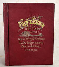
1893ref. 1908200047Philadelphia : Burke & McFetridge Co 1893. First Edition. Hardcover. Very Good. Bound in publisher's red cloth with gilt lettering and bridge on front. Hardcover. Good binding and cover. Clean unmarked pages. 108 pages : illustrations ; 26 cm. All edges gilt. Numerous illustrations photographs and ads related to Philadelphia and railroads. Text includes a history of the Association; an interesting essay on the "origin and progress of architecture and building" by George W. Andrews; and an essay on "Associations as an educational factor." Illustrates a number of Philadelphia buildings and gives their architects. Philadelphia : Burke & McFetridge Co hardcover
1846ref. 0008413London: Richard Bentley 1846. First edition. Hardcover. Very Good. Steel Engravings and woodcuts. 8vo; ix 437 pages contemporary 3/4 brown morocco marbled papers rubbed extremities tight all edges gilt 10 steel Engravings and 19 wood engravings. Nathaniel Armstrong Wells was a high-born wealthy man of mixed parentage: three-fourths European one quarter African. Richard Bentley hardcover
1891ref. DEMO014105IPhiladelphia: John Y. Huber 1891. First edition. Hardcover. Very Good. 53 inserted portraits. Quarto 745 pages blue cloth repaired hinge some internal cracking unopened; ex libris Frank D. Kellogg. In addition to a comprehensive history this work incorporates nearly 200pp. of the Proceedings of the Celebration of the 100th Anniversary of the Organization of the U.S. Supreme Court. It includes the remarks by Chief Justice Melville Fuller and Justices Field & Harlan. Grover Cleveland spoke and chaired the Executive Committee. Etched portraits by Albert & Max Rosenthal. 53 inserted portraits. Author Carson became Attorney General of Pennsylvania. John Y. Huber hardcover
1889ref. ARCH120MEdité par Dujardin & Cie, Paris, 1889. Quatrième année. (28x35,5cm.) 2 volumes : 636pp + 104 planches. Plans en n&b. Couverture rigide. Epidermures sur les premières et dernières pages, couverture abîmée par le temps. L’intérieur reste en bon état.
18318vo., First and Sole Edition, endpapers very lightly spotted; attractively bound in contemporary green half morocco, straight-grain cloth boards ruled in gilt, back gilt extra with five raised bands, second compartment lettered and ruled in gilt, all other compartments tooled and ruled in gilt, marbled endpapers, marbled edges, covers very lightly age-scuffed else a most attractive copy. Scarce, especially in this condition. Anderson, p.183.
1898Very Good Turkish, Ottoman (1500-1928) Original color map. Folded. Atlas folio. (82 x 57 cm). In Ottoman script. Scale: 1/400000. A clean copy. Including Azerbaijan, Dagestan, Mahaçkala, Tbilisi, Yerevan, Darband, et alli. A fine map of Caucasus and shores of Caspian Sea. Extremely rare.
1894ref. 1511101Jena, G. Fischer, 1889 - 1894. 4to. 40, 281, (1); 6, 81, (1) S. m. zus. 155 Abb. u. 6 Kartenskizzen, 22 Lichtdrucktaf. (Gesamtreihe Heft 19, 20 u. 5). Neuer Lwdbd m. aufgezogenem OVorderumschl. (Papier teils gebräunt, teils gelbfleckig, mehrf. gest.).
1889Outer dimensions: 10.75" x 14.5". Includes many street names. Principal buildings, steam roads and horse roads indicated. Clean and unmarked with light wear. An attractive vintage copy. Book
1835ref. 0009264London: John Weale Architectural Library 1835 / 1836. First edition. Good. 8vo 476 pages plates marginal tear in leaf 169/170; full polished calf extra-gilt spine extremities worn. Note: attempted collation but very complicated despite lengthy mixed-up descriptons in the text and duplicate numberes on different plates. The title-page is dated 1835; the engraved frontispiece is dated 1836; AND another third title-page is 1836 - but with a variant title !! Embracing Account and Illustrations of St. Stephen's Chapel and its Cloisters . Westminster Hall . The Court of Requests . The Painted Chamber &c &c. This work was inspired by the burning of the Houses of Parliament in 1834. It is illustrated with 48 engravings - 8 more and 100 pages more than promised to their subscribers. John Weale, Architectural Library unknown
1894Very Good Turkish, Ottoman (1500-1928) Original color lithograph map. Folded. Oblong folio. (35 x 52 cm). In Ottoman script (Old Turkish with Arabic letters). It shows Sudan and West Africa, Atlas Ocean shores, Sahra Desert, and other parts of Africa. Scale: 1:15.000.000. A very detailed and attractive map. Slightly fading. Otherwise a very good copy. Dated Hegira: 1310 = [Gregorian 1894]. Taken from his attractive atlas titled "Yeni cografya atlasi. [i.e. New Geographical Atlas]". The cartographer, Ali Seref, or Hafiz Ali Seref (or Esref) Pasha (1840-1907) was an Ottoman soldier and mapmaker who was schooled in Paris as a cartographer around 1862. While in Paris he published his first atlas with 22 maps, called the Yeni atlas. Upon his return to Istanbul, he became the chief cartographer at the Matbaa-i Amire Printing Press in Beyazit. Chipping on extremities. Slight foxing. Overall a good copy. Not in OCLC.; Not in TBMM Map Collection.
1876Very Good German Original color map on cloth. A little foxing on cloth. Very good. Folded. Oblong folio. (45 x 51 cm). In German. Shows N. Enyed, Zalathna, Mediasch, Hermannstadt, Hatszeg, Petroseni, Ôzt River, etc. Scale: 1/300,000. Sibiu (Sibiiu - Hermannstadt - Nagyszeben) is a city in Romanian Transylvania. The city straddles the Cibin River, a tributary of the river Olt. The first official record referring to the Sibiu area comes from 1191 when Pope Celestine III confirmed the existence of the free prepositure of the German settlers in Transylvania, the prepositure having its headquarters in Sibiu, named Cibinium at that time. In the 14th century, it was already an important trade center. As of the year 1376, the craftsmen were divided into 19 guilds. Sibiu became the most important ethnic German city among the seven cities that gave Transylvania its German name Siebenbürgen (literally "Seven Citadels"). It was home to the Universitas Saxorum (Community of the Saxons), a network of pedagogues, ministers, intellectuals, city officials, and councilmen of the German community forging an ordered legal corpus and political system in Transylvania since the 1400s. During the 18th and 19th centuries, the city became the second -and then the first most important center of Transylvanian Romanian ethnics. The first Romanian-owned bank had its headquarters here (The Albina Bank), as did the ASTRA (Transylvanian Association for Romanian Literature and Romanian's People Culture). After the Romanian Orthodox Church was granted status in the Habsburg Empire from the 1860s onwards, Sibiu became the Metropolitan seat, and the city is still regarded as the third-most important center of the Romanian Orthodox Church. Between the Hungarian Revolution of 1848 and 1867 (the year of the Ausgleich), Sibiu was the meeting-place of the Transylvanian Diet, which had taken its most representative form after the Empire agreed to extend voting rights in the region (Source: Wikipedia). A sheet of the collection of 'The general map of Central Europe'. appeared in the years between 1873-1876 with the work of Joseph Ritter von Scheda, (1815-1888) who was a general, geographer, and cartographer.
1900Very Good German Original b/w city plan. Atlas folio. (58x47 cm). In German. Folded. [CITY PLAN of BRAILA -IBRAIL-] Stadtplan von Braila. Scale (Masstab): 1/10.000. No cartographer. 33 descriptive articles on bottom-right corner of the plan. Slightly chipped at extremities of paper and soiling. It shows Braila and Donau. Braila (Turkish: Ibrail) is a city in Muntenia, eastern Romania, a port on the Danube and the capital of Braila County.
1900Very Good Turkish, Ottoman (1500-1928) Original color map on cloth. Oblong: 67x75 cm. In Ottoman script. Folded originally. A very detailed map. Scale: 1:210.000. Shows Shkodra Lake, its shores, Bog Mountains, Karadag (Montenegro), Iakoh, Has etc. [MAP of OTTOMAN PROVINCE of BALKANS-ALBANIA] 52 Ipek (Peja). 53 Yakoh. 59 Akola. 60 Iskodra (Shkodra).
1876Very Good German Original color map on cloth. Chipped on folded places. Otherwise a clean copy. Oblong atlas folio. (46 x 52 cm). Scale: 1/300.000. Toponyms in German. Shows Gallipoli [and the Hellespont, Edremid Gulf, Imbros, Tenedos, Lesbos (Midilli), Aivali (Ayvalik) and North Aegean shores of Anatolia]. A sheet of the collection of 'The general map of Central Europe'. appeared in the years between 1873-1876 with the work of Joseph Ritter von Scheda, (1815-1888) who was a general, geographer and cartographer.