HEJAZ RAILWAYBiblio.com
9480 risultati
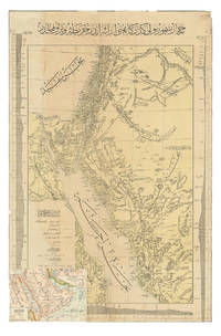
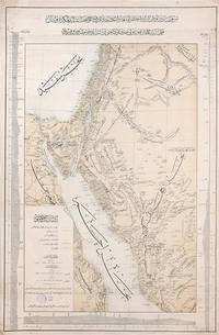
1903rif. 163825Constantinople: Matba'a-i Bahriye "The Press of the Navy" 1319 Rumi 1903. Mapping the great Hejaz Railway the embodiment of Hamidian Pan-Islamism A rare and important official map depicting the route of the Hejaz Railway based on a manuscript drafted under the supervision of the "brilliant Turkish engineer" Hadji Mukhtar Bey Maunsell p. 585 who served as the chief of operations. It was issued in 1903 while the main line from Damascus to Medina was still under construction but after the final route had been established. This detailed large-format map covers most of Syria all of Palestine the Sinai Peninsula the Suez Canal and all the north-western Arabian Peninsula. It delineates those parts of the railway that are in place and those under construction with each station labelled. Additionally it depicts the two alternative routes proposed for extending the line to Mecca as well as the proposed but unrealized route of a rail line from Mecca to the port of Jeddah. The map also labels important roads and caravan routes. In September 1907 four years after publication of this map the railway reached AlUla. Although AlUla is not marked here Mada'in Salih modern al-Hijr/Hegra is present which was a significant station responsible for the maintenance of locomotives. Mada'in Salih was UNESCO's first World Heritage Site in Saudi Arabia and comprises "a major site of the Nabataean civilization in the south zone of its influence" UNESCO. Construction of the Hejaz Railway began in 1901 and by 1908 had reached Medina 400 km short of Mecca where for various political reasons it had to be terminated. Until the outbreak of the First World War it allowed hundreds of thousands of pilgrims to make the hajj in safety and with relative ease. For the first time branch lines provided a rapid link from Syria to Palestine. The moving figure behind this map was the veteran military engineer Hadji Mukhtar Bey who had conducted "military-scientific expeditions in east Africa Harrar and the Somali coast in the 1870s and early 1880s producing the first 'correct' cartographic maps of the region" El Shakry p. 42. It was he along with fellow officer Ali Rida al-Rikabi later first prime minister of modern Syria who originally assessed the route when they joined the 1900 hajj. Initial field surveys for the present map were conducted by two Ottoman cavalry officers Captain Umar Zaki and Lieutenant Hasan Mu'ayyin. In an interesting article in Jerusalem Quarterly Zeynep Celik and Zeinab Azarbadegan pay particular attention to this map and note that the Ottoman Navy "produced different versions of the map in Arabic and Ottoman Turkish pointing to the multiple purposes and audiences targeted within and beyond the empire. The mass production of maps demonstrates the Ottoman state's attempt to disseminate cartographic knowledge about the empire to the public. This speaks to the third and final aspect of analysis of the Hejaz Railway: its use as a tool of Ottoman state propaganda during the Hamidian era". There are at least two states of this map with slightly different titles. Colour lithographic map 800 x 520 mm coastal profiles of the Red Sea in left and right margins script in Ottoman Turkish. Light vertical creasing throughout minor foxing publisher's stamp in the cartouche marginal small tears repaired with old paper. A very good example. Zeynep Celik & Zeinab Azarbadegan "Late Ottoman Visions of Palestine: Railroads Maps and Aerial Photography" Jerusalem Quarterly 82 Summer 2020; Lieut.-Col. F. R. Maunsell "The Hejaz Railway" The Geographical Journal Vol. 32 No. 6 Dec. 1908; Omnia El Shakry The Great Social Laboratory: Subjects of Knowledge in Colonial and Postcolonial Egypt 2007. unknown
1904rif. ABC_47091Constantinople: Matba a-i Bahriye 1904. Colour-lithographed map 76.5 x 49.5 cm trimmed to neat line. A rare separately issued official railway map with the entire text in Ottoman Turkish depicting the route of the Hejaz Railway. Following a route proposed by the eminent Turkish engineer Mukhtar Bey and surveyed by the cavalry officers Umar Zaki and Hasan Mu'ayyin the epic project funded by subscriptions from the global Islamic faithful completed a rail link from Damascus to Medina by 1908. The present map shows the intended continuation to Mecca never completed. Although it went no further south than Medina the railway nevertheless briefly allowed many thousands of pilgrims to make the Hajj in relative comfort bringing them to Medina and within about 300 km of Mecca. It shows the northern half of the Red Sea the Sinai peninsula the southeast corner of the Mediterranean Sea and what were to become Palestine most of Jordan and parts of Lebanon and Syria.A contemporary Ottoman colour-lithographed map of the Arabian Peninsula has been pasted over the lower left corner below the key like an inset map hiding only a tiny bit of the main maps topographic image. Old folds and creases some small tears repaired tiny chips to neat line some light stains. Some remnants of tape and old private collector's stamps on the back. Still in good condition. Matba a-i Bahriye, unknown
1902rif. 00011029 × 20 cm. Comprising 158 text plates including 95 photographs produced by the committee of which 42 photographs appear on separate plates measuring approximately 23 × 15 cm. The work documents the Photography Committee's journey from Istanbul to MaÊ¿Än in Transjordan. The accompanying text was compiled from articles originally published without illustrations in various issues of the newspaper Vakit "Time" in 1902. This is a unique work prepared for publication with photographs taken by a private committee that included prominent figures such as the German general Karl Auler Pasha who served as an adviser on Hejaz affairs until the fall of Medina in 1918. hardcover
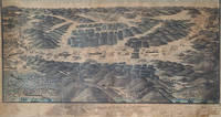
1910rif. 000240This remarkable collection relating to the Hejaz Railway includes; 1 An original signed oil painting by its artist together with the handwritten memoirs of an Ottoman officer and a manuscript route diagram indicating the railway's distances measurements and train itinerary. The oil painting measures 91 × 51 cm and was executed in oil by Hajj Muhammad Firaqi Ayyubi signed and dated 31 Dhu al-Qa'dah 1328 AH 1910 CE. The painting presents an exceptionally detailed panoramic representation of the Hejaz Railway illustrating every station along the line together with the geographical character of its surroundings including villages and towns. It depicts the railway's natural setting—mountains seas valleys city walls and tunnels—as well as symbolic representations of urban buildings moving trains distances between stations branch railway lines government buildings in selected towns and military forts. Rich in topographical and historical detail the work functions as a visual book portraying the Hejaz Railway as though it were seen in reality. An extensive explanatory text in Ottoman Turkish occupies the lower section of the painting describing the purpose of the work and the method by which it was produced. Particular attention is devoted to regions such as Haifa Rayak Aleppo and Mada'in Salih with references to their ancient history the historic pilgrimage route and the Imperial Surre the Ottoman annual caravan carrying gifts and financial endowments to the Holy Cities. The title prominently inscribed at the center of the lower section reads: "General View of the Hejaz Railway from Medina al-Munawwara to Noble Damascus Drawn According to the Principles of Cartography." This is a unique and previously unrecorded example combining artistic excellence cartographic precision and historical documentation in a single work. 2 Manuscript Memoirs of an Ottoman Officer: A Modest Journey from Istanbul to Medina This manuscript comprises the handwritten memoirs of an Ottoman officer named Kehyâzâde Mehmed Ali Cevad entitled A Modest Journey from Istanbul to Medina. It consists of 100 pages with most pages containing 19 lines of text and measures 18.5 × 11.5 cm. The manuscript is illustrated with several original hand-drawn plans including: a full-page plan of the Hejaz Railway station at al-Marjah Marjeh Damascus; a plan of a fortress near Kilometer 760 in the al-Akhdar region of northern Arabia; a plan of al-Mu'azzam Station at Kilometer 827; another plan at Mabrakat al-NÄqah around Kilometer 918; a sketch of one of the monumental gateways of MadÄ'in á¹¢Äliḥ near Kilometer 1049; and an unfinished two-page plan of the Prophet's Mosque al-Masjid al-Nabawi in Medina. The manuscript also contains a separate second section independent from the Hejaz Railway memoirs written by another Ottoman officer who was the brother of the author of the first section. This part records the return journey from Istanbul to Bandırma and İzmir following the author's return from the Hejaz. The memoir opens with an account of the political and social conditions in Istanbul following the deposition of Sultan Abdülhamid II. It then narrates the journey on the Hejaz Railway beginning on 18 April 1325 Ottoman Fiscal Calendar and continuing until 2 May 1325. The author records the journey in remarkable detail following the railway kilometer by kilometer. He describes the geographical landscape topography architectural features the condition of the railway stations the railway line and its extensions as well as the demographic social and regional characteristics of the areas traversed. He also notes the prevailing weather conditions and carefully records place names and distances continuing his observations up to Kilometer 1299 in Medina where he provides a particularly detailed description of the city's railway station architecture and principal landmarks. These memoirs constitute an exceptionally rare example of an Ottoman travel account devoted to the Hejaz Railway distinguished by its meticulous documentation of the railway its stations and the surrounding landscape. 3 A Hejaz Railway Train Operations Table effective 25 July 1328 Ottoman Fiscal Calendar measuring 61 × 45 cm. The chart records the elevations of the terrain between each pair of stations above sea level the topographical characteristics of the route the distances in kilometres and the function of each station with particular detail given to the principal stations from Mada'in Salih through Al-'Ula Al-Bada'i and Al-Hadiyyah to Medina. The table also sets out the train timetable over a 24-hour period indicating movements on the main line and the station sidings branch tracks. In addition it illustrates the track junction and turnout configurations at every station along the route.
rif. 2658Lausanne, Impr. Centrale,1943 ; 8°, broché.