1712 risultati
1843rif. 24449Rome Imprimerie de la Propagande 1843 in-4 chagrin vert foncé, dos à nerfs orné de caissons de filets à froid et de fleurons dorés, jeu de filets à froid encadrant les plats, fleurons dorés aux angles, croix latine dorée au centre, dentelle intérieure, tranches dorées [Rel. de la fin du XIXe siècle], lég. rest
rif. 3122P., Demonville, 1803, un volume in 8 relié en demi-basane mouchetée, dos orné filets dorés (reliure moderne à l'imitation), 10pp., (1), 480pp., 2 planches hors texte
1681In-4 (mm. 310x200), 2 parti in 1 volume (ciasc. con proprio frontesp.), p. pelle bazana coeva (restaurata), dorso a cordoni (rifatto), pp.num. (6),220,(4, di Indice); (2),456,(8, di Indice), con una bella antiporta allegorica incisa, titolo in rosso e nero, testo su due colonne. il volume è arricchito da una straordinaria documentazione iconografica di 39 tavole inc. in rame f.t. (come da Indici) così composte: 31 tavole (di cui 23 a doppia pagina e a volte anche ripieg.) che illustrano bellissime vedute delle più importanti località (tra cui Damasco, Aleppo, Tripoli, Jaffa, Rama, etc.), la storia, gli usi e i costumi dei Siriani e dei Palestinesi e 8 grandi carte geografiche + 34 preziose vignette, sempre inc. in rame, nel t. La città di Gerusalemme è raffigurata anche in un magnifico panorama a volo d’uccello, più volte ripieg. Rara "prima edizione" tedesca di questa famosa opera sul Medio Oriente, scritta dapprima in lingua olandese nel 1677; l’edizione tedesca fu tradotta e pubblicata da Jacob von Meursen, autore anche delle incisioni in rame che la illustrano. Cfr. Tooley’s Dictionary of Mapmakers, p. 147 - Graesse,II, 335. "Olivier Dapper (1636-1689), médecin hollandais, joignit à la pratique de son art l'étude de l'histoire et surtout de la géographie. Il recueillit tout ce qui pouvait faire connaitre les pays étrangers, et composa des descriptions très étendues et très intéressantes. Il orna ses ouvrages de cartes et de figures nombreuses. Les planches, bien dessinées et gravées avec soin, représentent avec assez de fidelité les lieux les plus importants et les usages des habitants. Parmi ses ouvrages (sur l'Afrique, l'Asie, la Perse, l'Amérique et la Terre australe), la ‘Description de l’Asie, contenant la Syrie et la Palestine ou la Terre Sainte’, traduit en allemand, Amsterdam, 1681, c’est le plus beau des ouvrages de Dapper”. Cosi' Biographie universelle,X, p. 538. Con antichi restauri solo margin. su alc. carte (e a p. 211 della prima parte, per un lungo strappo), tracce d’uso più o meno pesanti e qualche alone, ma complessivam. buon esemplare.
1896Very Good English Modern full leather each volumes in traditional Ottoman style. Roy. 8vo. (25 x 17 cm). In Ottoman script. Last 2 volumes are in Modern Turkish. 10 volumes set: ([23], 674, [10] p.; 479, [5] p.; 534, [5] p.; 432, [4] p.; 602, [6] p.; [4], 554, [5] p.; [21], 912 p.; [1], [5], 786, [4] p.; 892 p.; 1112 p)., folding maps, b/w plates. 1896 - 1938. Their contents are: Vol. 1: Description of Contantinople and environs, as of 1631. Vol. 2: Journey to Brousse and Nicomedia, 1640, Pontus, Caucasus and Crimea, 1640-44.i expedition to Crete, 1645; journey to Erzerum and Caucasus, 1648. Vol. 3: Syria, Kurdistan, Armenia, 1650; Roumelia, Bulgaria and Dobrudja, 1655-56. Vol. 4: Persia and Iraq, 1655-56. Vol. 5: Journey to Moldavia and expeditions to Transylvania and Russia, 1658; to Anatolia, then across the Dardanelles to Adrianople, 1659; expeditions to Moldavia and Dalmatia, 1660. Vol. 6: Expedition to Transylvania and journey to Albania, 1661-62; expeditions to Hungary, Montenegro and Croatia, 1663-64. Vol. 7: Austria, Crimea, Daghestan, Caucasus, Astrakhan. Vol. 8: Crimea, Crete, Salonica, Roumelia (Greece). Vol. 9: Pilgrimage to Mecca and Medina. Vol. 10: Egypt. Evliya Çelebi was son of the chief court jeweler, he was educated in a madrasah (Islamic college) and a Qur?an school in Constantinople; and, excelling as a Qur'ân reciter, he was shown favour by the reigning sultan, Murad IV. Entering the Ottoman palace school, he developed skills in Arabic, calligraphy, and music. Under the patronage of the court he began the journeys that took him from Belgrade to Baghdad and from Crimea to Cairo, sometimes as an official representative of the government and sometimes on his own. The result of these travels was his masterwork, the Seyahatname (1898-1939; 'Book of Travels'). This work is also referred to as the Tarih-i seyyah ('Chronicle of a Traveler'). Evliya possessed a vivid imagination, occasionally mixing fact and fantasy; he described places he could not possibly have visited. Noted for his fascinating anecdotes and charming style, he wrote about the ethnography, history, and geography of the Ottoman Empire and neighbouring lands and about the inner workings of the Ottoman government during the 17th century. (Source: Britannica). Currently there is no English translation of the entire Seyahatname, although there are translations of various parts. The longest single English translation was published in 1834 by Joseph von Hammer-Purgstall, an Austrian orientalist: it may be found under the name "Evliya Efendi." Von Hammer-Purgstall's work covers the first two volumes (Istanbul and Anatolia) but its language is antiquated. Other translations include Erich Prokosch's nearly complete translation into German of the tenth volume, the 2004 introductory work entitled The World of Evliya Çelebi: An Ottoman Mentality written by University of Chicago professor Robert Dankoff, and Dankoff and Sooyong Kim's 2010 translation of select excerpts of the ten volumes, An Ottoman Traveller: Selections from the Book of Travels of Evliya Çelebi. Evliya is noted for having collected specimens of the languages in each region he traveled in. There are some 30 Turkic dialects and languages cataloged in the Seyâhatnâme. Çelebi notes the similarities between several words from the German and Persian, though he denies any common Indo-European heritage. The Seyâhatnâme also contains the first transcriptions of many languages of the Caucasus and Tsakonian, and the only extant specimens of written Ubykh outside the linguistic literature. First Printed Set of Evliya Chalabi's book(s) of travels. Voyages and Travels in Greece, the Near East and adjacent regions made previous to the year 1801; being a part of a larger catalogue of work on geography, cartography, voyages and travels, in the Gennadius Library in Athens, compl. by Shirley Howard Weber, Vol. II: 1631.; TBTK 10360.; Özege .; Only 2 copies located in OCLC as set: 80395042. Rare as set.
rif. 42636Piazza.1918.In-4 relié en portefeuille.177 p. Illustrations d'Etienne Dinet et Mohamed Racim.Exemplaire n°584.177 p.avec la carte du Hedjaz et la Route de la Syrie, la table des illustrations et celle des chapitres.Reliure de J.Bosco,relieur à Alger. Ouvrage unique,ayant appartenu à Henry Frugès,qui en a inspiré la reliure et les soies de doublures et de gardes.Plein maroquin mosaiqué de toutes les couleurs.Larges bandeaux et motifs orientalistes.Rabat en portefeuille à l'identique avec doublure de soie.Tète dorée.Très bel ouvrage.
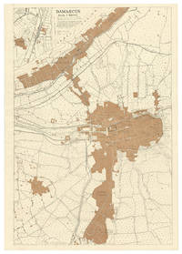
1918rif. M2BH82CWPN7GDamascus: Field Survey Company. R.E. E.E.F. 1918. Map of Damascus 73.5 x 51 cm printed in black and tan on a scale of 1:10000. Extremely rare British map of Damascus with a more detailed inset map of the area around Kadem Station to the west of the city centre the northern terminus of the Hejaz railway between Damascus and Medina especially rare in its present first state published by the British forces only a week after the fall of Damascus. Drafted by the Royal Engineers from a captured enemy map dated June 1918 with additional detail of Kadem Station from aeroplane photographs taken by the R.A.F. and printed under the surveyors supervision in the field probably in Damascus on a portable press carried by the Field Survey Company.The ancient city of Damascus one of the final prizes taken by the British and allied forces in World War I was long a great cultural centre the head of the Syrian Hajj Road and more recently the northern terminus of the Hejaz Railway and the headquarters of the Ottoman-German forces in the Middle East. In the last months of the war British forces met stiff resistance in Palestine and it was only weeks before the end of the conflict that they managed to break into Syria. British forces and their allies captured the Damascus on 1 October 1918. Lawrence of Arabia who was part of the conquering force was disappointed not to have been amongst the first allied troops to enter the city especially as he envisaged Damascus as the future capital of an independent and unified Arab state and Prince Feisals army supported the British and allied forces with that understanding unaware that the British and French in 1916 had made a secret agreement to divide the Ottoman territories outside the Arabian peninsula among themselves. Although Feisals troops did raise their flag in Damascus on 1 October and declare an independent Syrian state it was in fact to be ruled as a French protectorate until 1945.All maps printed by British and allied forces in the field in the Middle East during WWI are extreme rarities. The present map would have been issued in only a very small print run for the use of senior British officers and printed on fragile paper in a large format its survival rate would have been very low. We can trace only a single other example of the map in its present first state held by the British Library. The British forces printed the map in a second state with some revisions for the Survey of Egypt in 1919 but it is also extremely rare in that second state.In very good condition clean and bright with just some minor creasing from having been rolled for many years.l British Library Cartographic Items: Maps 48855.11; WorldCat 557017180 same copy; cf. 557017192: 1 copy of 1919 revision. Field Survey Co[mpan]y. R.E., E.E.F., unknown
1837rif. 227601837-1838 et s.l. sur 24 feuillets de formats divers (de 11 x 19 cm à 30 x 32 cm) conservés dans une boîte moderne de papier peigne, piqûres et taches éparses
Amsterdam & Leipzig, chez Arkstée & Merkus, 1749- T. X - E.O. - 1 volume In-4 - 1/2 Reliure, Plats muets - T. X - Table (2), 680 pages - Frais intérieurement. - Gravure dépliante du Palais de Néron, Plans dépliants du grand cirque commencé par Romulus & Hippodrome avec l'obélisque Theboine. - Carte dépliante du Bosphore de Trace avec Constantinople divisée en quartiers.
Amsterdam & Leipzig, chez Arkstée & Merkus, 1743 - T. IIII- E.O. - 1 volume In-4 - 1/2 Reliure, Plats velin de réemploi (d'époque) - Epitre dédicatoire (4), Plan de l'ouvrage (4), Préface (62), 574 pages - rousseurs éparses -La préface comprend les de longueur, a nglaises, Grecques, Romaines dans l'Ecriture, les Monnaies (14 pages) - envoi rapide et soigné. Taduction française de l'ouvrage de ...... Vers 1730, on publia les premiers numéros d'une vaste entreprise littéraire, proposée par souscription dont le plan avait été dressé par M. Sale, habile dans les langues orientales : c'était une histoire universelle de tous les peuples du monde. Comme cet ouvrage obtenait peu de succès, les propriétaires, ayant appris que Psalmanazar avait dirigé ses études sur l'histoire ancienne, lui proposèrent de coopérer à cette entreprise. Il y consentit, à condition que l'ouvrage soit rédigé dans un tout autre esprit et que les écritures saintes soient prises pour base. Dès que Psalmanazar eut mis à jour les volumes dont il était l'auteur, le nombre des souscripteurs augmenta considérablement. Il s'y consacra jusqu'à sa mort en 1763. Cette compilation eu un très grand succès. Elle contient notamment l'histoire des Juifs, des Celtes, l'histoire ancienne de la Grèce, de l'Espagne, l'histoire des anciens Empires de Nicée et de Trébizonde, les histoires des Germains et des Gaulois, l'histoire de Thèbes et de Corinthe, la retraite des dix-mille pour la partie ancienne;...."L'histoire ancienne est plus estimée que la moderne". Brunet III -212....
Amsterdam & Leipzig, chez Arkstée & Merkus, 1745 - T. VI- E.O. - 1 volume In-4 - 1/2 Reliure, Plats velin de réemploi (d'époque) - Epitre dédicatoire à Procope Aldabert, Comte Czernin de Chudernitz avec Armoiries (4), (2), 692pages - Frais intérieurement. - 4 Cartes dépliantes des conquètes d'Alexandre, de la Syrie après la mort d'Alexandre le Grand, d' Egypte & Cyrenaique & des royaumes d'Arménie, de Pont, de Capadocie & de Médie
LA HAYE, H. scheurleer, 1748 - E.O. - In-4 - 1/2 Reliure très frottée, avec manques, plats velin de réemploi (d'époque) - - (2), 678 pages - - 2 Cartes de la Syrie et de la Phénicie, Etats desCananéens, Moabites, Hammonites, Madianites, Iduméens, Amalécites avant et lors de la sortie des Israélites d'Egypte - 5 planches dépliantes deTadmor, Palmire, Sépultures phéniciennes, Camp d'Israël - Frais intérioeurement Taduction française de l'ouvrage de ...... Vers 1730, on publia les premiers numéros d'une vaste entreprise littéraire, proposée par souscription dont le plan avait été dressé par M. Sale, habile dans les langues orientales : c'était une histoire universelle de tous les peuples du monde. Comme cet ouvrage obtenait peu de succès, les propriétaires, ayant appris que Psalmanazar avait dirigé ses études sur l'histoire ancienne, lui proposèrent de coopérer à cette entreprise. Il y consentit, à condition que l'ouvrage soit rédigé dans un tout autre esprit et que les écritures saintes soient prises pour base. Dès que Psalmanazar eut mis à jour les volumes dont il était l'auteur, le nombre des souscripteurs augmenta considérablement. Il s'y consacra jusqu'à sa mort en 1763. Cette compilation eu un très grand succès. Elle contient notamment l'histoire des Juifs, des Celtes, l'histoire ancienne de la Grèce, de l'Espagne, l'histoire des anciens Empires de Nicée et de Trébizonde, les histoires des Germains et des Gaulois, l'histoire de Thèbes et de Corinthe, la retraite des dix-mille pour la partie ancienne;...."L'histoire ancienne est plus estimée que la moderne". Brunet III -212....
Amsterdam & Leipzig, chez Arkstée & Merkus, 1746 - T. VII- E.O. - 1 volume In-4 - 1/2 Reliure, Plats muets - T. VII Epitre dédicatoire à Monsieur le comte Jumoius Gebhard de Hoym, Seigneur de Droysig, etc.. avec Armoiries (4), (2), 538pages + Table des 7 tomes contenues dans cette histoire universelle - Frais intérieurement. - 2 Cartes dépliantes Palestine et Terre Sainte, de la Parthie et la Perse. . - 2 Plans de la ville de Jérusalem, suivant Josephe et les Rabbins et de la Cour intérieure de l'Autel etc.. dans le sacrifice à la fête des Tabernacles.