6.368 Ergebnisse
Best.-Nr. 56-0231San Francisco Calif.: Southern Pacific Company 1934. Map. Typewritten correspondence handwritten calculations and charts switching charges chart in 8 colors switching district and industrial maps rate and charge sheets. Includes circa 1928 map of Oakland Harbor. Harbor map: 19 x 47 inches. Scale: 1 inch = 1500 feet. Switching zone map: 22 x 28 inches. 25 pp. including inserts. San Francisco, Calif.: Southern Pacific Company, 1934. unknown
Best.-Nr. 56-0234San Francisco Calif.: Southern Pacific Company 1931. Map. Blueline print. 24 x 48 inches. Map of Oakland Railroad Yard from Passenger Ferry to East Yard Limits. Includes list of nine transfers or cannonball moves and list of approximately 40 intersection/ DH correspondences. Scale: 1 inch = 1500 feet. San Francisco, Calif.: Southern Pacific Company, 1931. unknown
Best.-Nr. 58-0502San Francisco Calif.: Southern Pacific Company 1948. Blueline print 28 inches x 22 inches. From Cutting Boulevard to Scott Avenue Lauritzen Canal to Fourteenth Street. Includes Parr Canal Shipways 1 - 7 HopCo Chemical Co Filice & Perrelli Canning. Scale 1 inch = 200 feet. San Francisco, Calif.: Southern Pacific Company, 1948. unknown
Best.-Nr. 56-0213Tucson Ariz.: Southern Pacific Company 1932 revised 1949. Map. Blueline print. 24 x 48 inches. Includes passenger station railroad yard switches. Scale: 1 inch = 500 feet. Tucson, Ariz.: Southern Pacific Company, 1932, revised 1949. unknown
Best.-Nr. 56-0438Fresno Calif.: Chamber of Commerce n.d. Blueline print 36" x 24" Marks Avenue to Willow Avenue and Annadale Avenue to Barstow Avenue. Red and yellow pencil shading highlight City Limits. With Central District map and street index approx 400 listings on back. Scale approx 1 inch = 0.3 mile. Fresno, Calif.: Chamber of Commerce, [n.d.] unknown
Best.-Nr. 56-0363Tucson Ariz.: Pacific Motor Trucking Company 1932 revised 1934. Map. Blueline print 33.5" x 32.5" with red and green lines and circles indicating first morning and afternoon L.C.L. shipments from Los Angeles or Bay Area. From Colombia River at Pacific Ocean to El Paso. Scale approx 1 inch = 40 miles. Tucson, Ariz.: Pacific Motor Trucking Company, 1932, revised 1934. unknown
Best.-Nr. 56-0362Tucson Ariz.: Pacific Motor Trucking Company 1949. Map. Blueline print 31" x 35" with red yellow and blue highlighting indicating Southern Pacific rail lines and Pacific Motor rights of passage. From Colombia River to El Paso. Scale approx 1 inch = 35 miles. Tucson, Ariz.: Pacific Motor Trucking Company, 1949. unknown
Best.-Nr. 56-0449Oakland Calif.: Southern Pacific Company 1929 rev. 1949. Blueline print. 8 x 52 inches. From Sevier Avenue to Del Norte Avenue along railroad tracks. Includes Newbridge Park Henderson. Scale 1 inch = 100 feet. Oakland, Calif.: Southern Pacific Company, 1929, rev. 1949. unknown
Best.-Nr. 56-0299Oakland Calif.: Southern Pacific Company 1960. Map. Blueline print 8" x 65" . Plan indicates railroad track communication wiring and two buildings. Includes Bishop Bros Warehouse Bishop Bros Wholesale. Scale 1" = 100'. Oakland, Calif.: Southern Pacific Company, 1960. unknown
Best.-Nr. 56-0405Oakland Calif.: Southern Pacific Company. Blackline print 16" x 12.5". Right-hand portion of map of Berkeley railroad yard incomplete. Left strip of map yellowed by adhesive. Includes Tracks 1 and 2 Boxcar loading buildings Acid Hause Mack Shop Hard Butter Bldg Mill Building Margarine Bldg Boiler Room. Scale 1" = 25'. Oakland, Calif.: Southern Pacific Company. unknown
Best.-Nr. 58-0558San Francisco Calif.: Southern Pacific Company 1952. Blueline print 24 inches x 33 inches red and green ink indicate present and proposed pickup and delivery limits. From State Highway 117 and Salinas-Monterey Road to Sherwood Lane Salinas Municipal Airport. Includes City of Salinas. Not drawn to scale. San Francisco, Calif.: Southern Pacific Company, 1952. unknown
Best.-Nr. 56-0364Sacramento Calif.: Pacific Motor Trucking Company 1948. Revised 1961. Map. Blueline print 12" x 56". Along West Railroad Ave near Power Inn Road intersection. Includes Brighton Park Black Diamond Lumber Co Alex Enghardt Roofing Valley Crane Service. Scale approx 1" = 100'. Sacramento, Calif.: Pacific Motor Trucking Company, 1948. Revised 1961. unknown
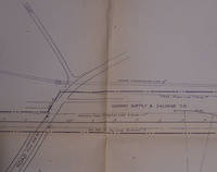
Best.-Nr. 56-0271San Francisco Calif.: Southern Pacific Company 1962. Map. Blueline print 24" x 83" From Belle Haven to Spring Valley Water Co. Includes Midway Supply and Salvage Co. Minimal details besides power lines and railroad line measurements and signs. Scale 1" = 100'. San Francisco, Calif.: Southern Pacific Company, 1962. unknown
Best.-Nr. 58-0473San Francisco Calif.: Southern Pacific Company 1938 rev. 1952. Blueline print 16 inches x 21 inches. Yard limits indicated in red highlighting. From approx 1/2 mile beyond yard limits east and west two miles north. Scale 5 inches = 1 mile. San Francisco, Calif.: Southern Pacific Company, 1938, rev. 1952. unknown
Best.-Nr. 56-0294San Francisco Calif.: Southern Pacific Company 1926 revised 1942. Map. Blueline print 24" x 36". From North Ninth St to Seventeenth St along Berryessa Road including approx 2 1/2 blocks in each direction. Includes California Packing Corp Modern Ice and Cold Storage Co. Scale 1" = 100'. San Francisco, Calif.: Southern Pacific Company, 1926, revised 1942. unknown
Best.-Nr. 56-0313San Francisco Calif.: Southern Pacific Company 1931 revised 1946. Map. Blueline print 24" x 36" with red and black pencilled notes. From city limits to Linden Ave and Bay Shore Highway. Includes South San Francisco Land and Improvement Co abandoned and open waterways Jonathan M Peel et al plot Union Oil Co Standard Oil Co. Scale 1" = 200'. San Francisco, Calif.: Southern Pacific Company, 1931, revised 1946. unknown
Best.-Nr. 56-0456San Francisco Calif.: Southern Pacific Company 1939. Blueline print from 24" x 55" to 30" x 55". Two maps cut and joined to detail switching limits in red pencil. Includes station point Lathrop. With two incomplete Schedules of Purchase approx 20 transfers missing information. Scale not indicated. San Francisco, Calif.: Southern Pacific Company, 1939. unknown
Best.-Nr. 58-0480San Francisco Calif.: Southern Pacific Company 1945. Blueline print 19 to 24 inches x 78 inches. Two maps joined with red pencil indicating switching limits. From Clear Creek at Girvan to beyond City of Redding. With City of Redding station point Girvan discontinued Standard Oil station. With Schedule of Property listing approx 30 transfers 1872 - 1945. Scale 1 inch = 400 feet. San Francisco, Calif.: Southern Pacific Company, 1945. unknown
Best.-Nr. 58-0494San Francisco Calif.: Southern Pacific Company 1936. Blueline print switching zones map14 inches x 32 inches switching zones indicated in red purple green yellow brown with red pencil. File cover indicating "Switiching Limits of San Francisco" dated 1962. Three pages of Switching Charges effective 1960 attached. San Francisco, Calif.: Southern Pacific Company, 1936. unknown
Best.-Nr. 56-0443San Francisco Calif.: Southern Pacific Company 1964. Blackline print 24" x 38". Topographical map of area around Giant with present and proposed railroad tracks indicated. From Pablo Bay to Richmond Golf Course extending approx 1 mile north and 1 1/2 miles east of Richmond Golf Course. Scale 1" = 300'. San Francisco, Calif.: Southern Pacific Company, 1964. unknown
Best.-Nr. 58-0561San Francisco Calif.: Southern Pacific Company 1932 rev. 1942. Blueline print 24 inches x 48 inches red pencilling indicates station points and spur tracks. From Fairview Home and Geer to beyond Fairgrounds. Includes Salem Pringle Pinckney Asylum Spur. Position of many industries indicated. Scale 1 inch = 800 feet. San Francisco, Calif.: Southern Pacific Company, 1932, rev. 1942. unknown
Best.-Nr. 58-0487Ogden Utah: Southern Pacific Company 1932 rev. 1945. Blueline print 21 inches x 48 inches. From two miles west of Reno yard to two miles east of Sparks yard. Both railway yards outlines in moderate detail. With red pencilling indicating switching limits. No industries indicated with listing of spurs and signals. Scale 1 inch = 800 feet. Ogden, Utah: Southern Pacific Company, 1932, rev. 1945. unknown
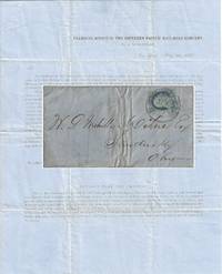
1857Best.-Nr. 010681New York 1857. Envelope or Cover. Very good. This printed circular is titled “Transfer Office of the Southern Pacific Rail-Road Company / No. 54 Wall-Street / New York May 30 1857.” It is addressed to W. P. Mehville Wilne Esq. of Sandusky Ohio and franked with an imperforate Franklin stamp Scott #9 canceled by a black circular New York postmark. In nice shape with a tiny bit of soiling to the edges. The notice reads in part: “An installment of fifty cents a share will become due and payable on the three percent. Stock held by you in the Company on the first Monday of July next. . . Stock on which said instalment shall not be paid will be sold at auction in conformity with . . . the Charter. . . “About sixteen miles of our ‘Road’ are now graded and nearly furnished with cross-ties – twenty-four hundred and seventy-eight tons of rail-road iron have been bought and paid for and sent up Red River – sufficient to finish twenty-five miles of road.” . The Southern Pacific Rail-Road referenced in this document is not the much more famous transcontinental route. This railroad was founded on 16 February 1852 officially as the Vicksburg and El Paso Railroad although throughout the document it was referred to as the Texas Western Railroad. It was later bought by the Atlantic and Pacific Railroad for $600000. It was later acquired by Texas interests and its named officially changed to the Southern Pacific Railroad the predecessor of the Texas and Pacific Railway. It was never associated with the later and more famous transcontinental Southern Pacific. During 1857 the railroad laid 23 miles of track between Marshall and Swanson’s Landing on Caddo Creek. During the Civil War the line was connected to Shreveport Louisiana. In 1872 it was sold to the Texas Pacific Railroad Company which in 1976 merged with the Missouri Pacific Railroad. For more information see Werner’s “History of the Texas Western Railroad Companies” and “History of the Texas and Pacific Railway Company” both at the Texas State Historical Association website. Scarce. At the time of listing no other documents from this Southern Pacific Railroad are for sale in the trade. Although no other 1857 circulars documenting the construction of the first 16 miles of its track have been sold at auction other materials related to it have. OCLC shows no materials related to this Southern Pacific Railroad are held by institutions however it is possible there may some within the Texas & Pacific Railway Collection at the University of North Texas. . unknown books
1908Best.-Nr. 12650The Pacific Telephone and Telegraph Co. Fine with no dust jacket. 1908. First Edition. Softcover. Still has the original string to hang it from. ; 8vo 8" - 9" tall; 488 pages . The Pacific Telephone and Telegraph Co. paperback
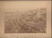
1900Best.-Nr. 42650Miles City Montana: Wiley Bros. Photographers Successors to L. A. Huffman 1900. Photograph. Very Good. Large format photograph 18.5 x 24 cm on a tan mount 25 x 30 cm. Wiley Bros. backstamp "Wiley Bros. Photographers Successors to L. A. Huffman. Miles City - Montana.". Mount edges are lightly bumped and chipped. Photograph is gently rubbed and lightly faded but still showing good detail and contrast. Shows many workers constructing the bridge with Northern Pacific Railroad cars visible in the background. Photograph taken from above looking down. In ink by hand on the front of the mount "Progress showing detail of bench walls of Culvert detail of brick arch; also general view of Coulee Bridge 148. Yellowstone Riv. River. Wiley Bros., Photographers, Successors to L. A. Huffman unknown