12 535 résultats
1858Gotha, Julius Perthes, 1858. 4to. Contemp, hcalf. Gilt spine. A small stamp to titlepage. VIII,596 pp. and 20, partly folded, lithographed maps and plans. Text as well as maps fine and clean.
1953London, Phoenix House Limited, (1953-54). Folio. 4 orig. hcloth, all in orig. slicase. Fine and clean. Text and fine facsimile-maps in colour.
réf. V00A-12754Hamburg-Bergedorf: Verlag Otto Heinevetter. Collectible - Good. Hamburg-Bergedorf: Verlag Otto Heinevetter 1982. Folio. Brown hardcover with gilt lettering on the front cover gilt top-edge. Facsimile of the 1652 publication. 40 full page maps. German edition. Near Very Good condition. Cover lightly scratched and soiled. The front and rear free endpapers have a large fold the front also showing light foxing. There is a short gifter's inscription to the front pastedown. Otherwise Very Good with light curling to a few lower corners. The title in English is "Schleswig-Holstein 1652. The maps by Johannes Mejer Husum from the new description of the two duchies of Schleswig and Holstein by Caspar Danckwerth D. 1652." books in German maps cartography Inquire if you need further information. NOT AVAILABLE FOR SHIPMENT OUTSIDE OF THE UNITED STATES. Hamburg-Bergedorf: Verlag Otto Heinevetter hardcover
réf. DADAX0785817530New unknown
1970réf. 2080502106505576Fukui Agata History Reprint Publishing Society 1970. Soft Cover. Fine. Number of books: 4 Fukui Agata History Reprint Publishing Society paperback
réf. DADAX0804749620New unknown
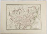
1837réf. 177519Paris. circa1837. Engraved map with original outline hand-colour 22 x 30 cm; 28.8 x 38.6 cm sheet marginal repair to the lower corner not affecting the map sheet lightly age-toned in very good condition preserved in a window mount. Fine map of China Japan and Central Asia noting Manchuria "Mandchourie" bordering Northern India and Turkestan in the West and Russia "Russie d'Asie" in the North. From the estate of the late collector and scholar Arthur Hacker with his pencilled catalogue mark on the verso. . unknown
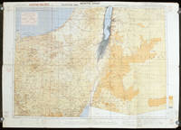
1942réf. 207841London.: Royal Engineers. July1942. Printed colour topographical map mounted on linen 56.7 x 79.2 cms; 64.6 x 89. 5 cms sheet original folds edgewear small marginal chips a little dusty but in good condition. Detailed World War II operational map of Egypt and the Middle East issued by 512 Army Field Survey Company of the Royal Engineers. The map is marked "Not to be Published" in the upper right margin. Railways roads camel tracks telegraph lines boundaries altitudes towns and villages are marked. . Royal Engineers. unknown
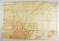
1419réf. 171112東京. Tokyo.: 伊林書店. Ibayashi Shoten. 昭和14 1939. Colour printed folding map 78 X 109cm minor damage original envelope 27.5 x 20cm. Very good copy. This map offers comprehensive information on northern China Manchuria the Soviet Union and Hokkaido including Kuril Islands under the Japanese control. It also includes the Jewish Autonomous State which existed in the late 1930s. The inset map provides detailed information on the border area of Japan Manchuria and the Soviet Union. Legends include national borders railways major cities iron mines and oil wells. Published in 1939 this map is an expression of the tension Japan felt in its relationship with the Soviet Union. At the time the Soviet Union was seen as the mighty threat to the lying just north of Manchuria and Japan . . 伊林書店. [Ibayashi Shoten]. unknown
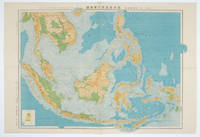
1572réf. 160538東京.Tokyo.: 日本名所圖繪社.Nihon Meisho Zuesha. 昭和16 1941. Folding colour Japanese map of the Malay Archipelago and Thailand scale 1: 8500000 with attractive original pictorial paper envelope. This map also shows the Dutch French and American colonies. Hainan Province and the South China Sea are shown in the north. Agricultural and mineral resources indicated across the map. Few small holes at holes and other light signs of wear. Slipcase lttle torn. Text in Japanese and English. 53.3 × 78.2cm. . 日本名所圖繪社.[Nihon Meisho Zuesha]. unknown
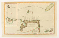
1784réf. 174895London.: Alexander Hogg at the King's Arms. circa1784. Engraved map on laid paper 21.4 x 33.7 cm inset of Gower's Simson's and Carteret's Island early outline hand colour trimmed to the plate mark at the top edge three small edge tears affecting the upper margin only slight paper toning but a most attractive map in very good condition. Fine impression of the Queen Charlotte's Islands Solomon Islands. It features the Swallow's track the ship's route taken by Captain Philip Carteret in 1767 the British naval officer and explorer who participated in two of the Royal Navy's circumnavigation expeditions in 1764–66 and 1766–69. . Alexander Hogg at the King's Arms. unknown
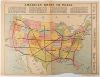
1938réf. 215547Los Angeles.: Los Angeles Examiner. Sunday 1 May1938. Printed colour pictorial map 33 x 48 cms; 41.8 x 54.5 cms sheet central fold sheet toned corners chipped with some loss to the bottom border and at the central fold in good condition; and on the verso "Movie-Go-Round" by Louella O. Parsons black and white photos and advertisements. Pictorial map printed for the weekend supplement of the Randolph Hearst owned newspaper the Los Angeles Examiner. The map-maker and artist Howard Burke had also worked for the San Francisco Examiner and was known for pictorial maps many with a persuasive or rhetorical edge and as here were designed to shore up American patriotism and defences against a wider world in the increasingly turbulent pre-war 1930s. The caption to this map outlines a multi-billion dollar 25 year proposal by Congressman J. Buell Snyder for a network of coast to coast transcontinental highways "in case of an attack by a foreign power at any point along the border". Buell Snyder earned the soubriquet "the father of superhighways" and during the War he was assigned to a Congressional Committee in charge of appropriations for the War Department. Scarce. . Los Angeles Examiner. unknown
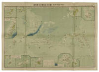
1819réf. 155215統正社 Tōseisha . Showa 18 1943. Colour folded map 54. x 76.5cm. Pinholes at corners light even browning good copy. This Japanese map of Micronesia shows the Mariana Islands Eastern and Western Caroline Islands Marshall Islands and Gilbert Islands. The separate maps around the edge are clockwise from the upper right corner: Jaluit Atoll Guam Island Rota Island Saipan Island Palau Islands Yap Island Hall Islands Pohnpei Island Truk Islands and Kusaie Island. . 統正社 [Tōseisha ]. unknown
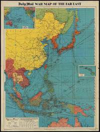
1944réf. 205765London.: George Philip & Son. 1944. Full colour folding map 101.5 x 76cm sheet inset maps legend folding into title wrapper 25.7 x 19.4 cm covers a little dusty and discoloured a few short fold splits without loss but the map in very good bright condition. Map of the Pacific Theatre of World War II with borders drawn as they stood in 1937 - complete with Chinese claims on Mongolia Tuva and Tibet. Shows transportation routes principal railways oil fields Allied naval bases territory occupied by the British Empire French Empire and the United States. This map shows only the northernmost section of Australia which allows for much better detail of the countries of East Asia. Small inset map of the Hawaiin Islands at mid right. Inset map of the Pacific Ocean at upper left. . George Philip & Son. unknown
1957réf. 86782chOttawa: Minister of National Defence 1957. Book. Near Fine. Hardcover. 8vo - over 7¾" - 9¾" tall. Three-volume set all gilt red cloth hardcovers. Published 1957 1958 and 1960 respectively incorporating corrections. Apart from moderate handling to covers slight toning to edges and an old owner's name inside front cover of each volume these are all clean tight and unmarked volumes. Very neat -- a sound and handsome set. Endpaper maps. Illustrated frontispiece. Illustrations and folding maps. Minister of National Defence Hardcover
1955réf. 2083002117401981Giho-sha 1955. Soft Cover. Fine. Volume: 1 Giho-sha paperback
réf. GOR008868049Paperback. Very Good. paperback
1900Very Good Turkish, Ottoman (1500-1928) Original lithograph map partly colored in brown tones. 82x56 cm. (Map print size: 50x46 cm). This map including four different map blocks on the paper. Three small ones include completely Asia, Baycal Lake, and North Russia. The big one includes a very detailed view of Japan, the Sea of Japan, Korea Strait, Korean Peninsula, Korean Bay, Yellow Sea, Shangai, Mongolia, Manchuria, and East Russian lands. No info about the cartographer. "The Cartographer Plotting School was opened to train the cartographers, especially when they were needed on military issues in the Ottoman State. Since there are differences between land maps and sea maps (in terms of measurements), the institution of surveyors emerged. When surveyors were needed also in the Navy, students at the Naval School were trained on this issue, and the gap for surveyors was covered in this way." (SCHOOL OF MAP DRAWING IN THE OTTOMAN STATE, Derya Geçili). Minor splits on foldings. Map in good condition generally.
1771réf. 27424Paris Lattré 1771 2 cartes anciennes colorées d'époque en vert , rouge et jaune, cartouche non coloré, gravée par Arrivet. Format total : 50 centimètres de haut par 39 centimètres de large, 1771 Paris Lattré Editeur,
réf. 0976373327-11-18Toucan Maps Inc. 2nd. Very Good. It's a well-cared-for item that has seen limited use. The item may show minor signs of wear. All the text is legible with all pages included. It may have slight markings and/or highlighting. Toucan Maps, Inc. unknown
réf. DADAX0190280913New unknown
1994réf. Q-0719550173John Murray 1994-01-01. Hardcover. New. In shrink wrap. Looks like an interesting title! John Murray hardcover
réf. 14486Without date or place. London Fire Force circa 1943. On one side of piece of 41 x 20.5 cm paper with lines and indications in light and dark blue red and green. In fair condition on aged paper with creasing and one closed tear towards the head. The map has Trafalgar Square at its head with the note that the two 'Basins' carry '40000 Galls. each' and Parliament Square at its foot. Whitehall and Parliament Street connect the two on the right of the map and to the left of the map is the lake in St James's Park: '200000 Galls Underground Tank Pumping Station 1400 Galls Pump 15 foot Gravity Main from Serpentine'. Also marked on the map are 'Inlet connections for L.F.F. Pumps and Pits' '6 Signle Outlet Suction Hydrants Round Thread' and 'Two 6 foot Steel Pipes in Subway Also under Embankment in Subway'. Down the centre of the map are the government buildings: the Admiralty Treasury Downing Street Foreign and Colonial Offices India Office and Home Office Office of Works Board of Education Board of Trade and Ministry of Health. No other copy found listed.Image on application. Without date or place. (London Fire Force, circa 1943.) unknown
1873réf. 8669Paris 1873. French naval chart sheet 3245 sheet size 51 x 36 cm engraved by Régnier after a British Admiralty chart of 1871 black and white blank verso. Akkeshi Bay located in Kushiro Subprefecture on the east coast of Hokkaido the most northerly of the main islands of Japan. Map unknown
1835réf. 785CGO.O., um 1835. Altkolorierte Aquatinta. Bildgrösse: 20 x 15,2 cm.