12.245 resultados
ref. 102221 62,7 x 53,3 cm encadrée ; 59 x 49,5 à vue, larges marges piqûées.
198392 pages. Based upon 15 tape recorded interviews with people of the Chilliwack area conducted in the early 1960s. Replete with historical photos and maps. Book
1929Folding coloured map on paper measuring 24 x 33 ins (approx. 61.0 x 84.0 cms) folding in 32 panels to 7.5 x 4.25 ins (approx. 19.0 x 11.0 cms), neat contemporary signature on front cover, one or two neat repairs at folds; original pictorial card wrappers, yapped edges, wrappers lightly age-soiled else a very good, bright, clean copy. The One Inch Tourist Map series was first published in 1924 with 'Official Royal Arms' artwork. The present copy is the 1929 revision; the cover is single red lineation on buff with black arms, red sheet name and location map. Browne, 8.1.a.1.
ref. ORD-7929Paris. Nathan. s.d. Jeu complet de 48 cartes illustrées en couleurs par Paul ORDENER, dans un coffret (160 x 118mm) de carton rouge orné d'une grande vignette couleurs. Tout petits défauts mais bon exemplaire bien complet de la règle du jeu (enfants de 7 à 12 ans).
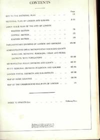
ref. 4551951589835357Geographia Ltd Fleet Street London. Hardcover. Good. THERE ARE NO TARIFFS OR CUSTOMS DUTIES ON BOOKS. Hardback. Used Very Good. Red boards with gilt title down the spine. Greater London Plans of London And Suburbs Parliamentary Administrative Postal Areas Underground.Railways Underground Stations and Bus or Tram Routes indicated on the maps.See photosThe maps are based upon the Ordnance Survey Maps with the sanction of the Controller of H.M. Stationery Office. Date not given but probably around 1930's. Copyright © Geographia Ltd Fleet Street London THERE ARE NO TARIFFS OR CUSTOMS DUTIES ON BOOKS. An audio offering from William.It's the beginning of the summer holidays and William and the Outlaws see an endless expanse of gloriously carefree days stretching ahead - but how to fill them. The six classic adventures contained in this unabridged reading are: William and the Holiday Centre; William's Treasure Trove; William and the Cottage; William Tackles the Job; William and Detective Journalism; and William and the Parsons' Guy. Read by Martin Jarvis. Copyright © BBC Audio Geographia Ltd Fleet Street London hardcover
ref. 455964Geographia Ltd Fleet Street London. Hardcover. Good. Hardback. Used Very Good. Red boards with gilt title down the spine. Greater London Plans of London And Suburbs Parliamentary Administrative Postal Areas Underground.Railways Underground Stations and Bus or Tram Routes indicated on the maps.See photosThe maps are based upon the Ordnance Survey Maps with the sanction of the Controller of H.M. Stationery Office. Date not given but probably around 1930's. Copyright A� Geographia Ltd Fleet Street London Geographia Ltd Fleet Street London hardcover
2004ref. 100177Great Britain: David & Charles 2004. Victorian Ordnance Survey Maps: London Originally engraved in the early 1820s these four maps cover the Victorian city of London and the surrounding area including Windsor Watford Brentwood Southend Maidstone Guildford and Bracknell. in very good slipcase We carry a wide selection of titles in The Arts Theology History Politics Social and Physical Sciences. Academic and Scholarly books and Modern First Editions and all types of Educational Reference Literature. . First Thus. Very Good. Maps . David & Charles unknown
1956The folded map is in very good condtion, the covers are dusty, (One Inch Map of Great Britain Seventh Series). eng
1952covers repaired. eng
1950No marks or inscriptions. A clean bright slightly sunned unmarked folded map opens up to 21 x 30 inches. Tears (2 and 3 inches) along two folds and small opening up at two corners 1pp. Ordnance Survey of Ireland quarter inch to 1 mile map of Killarney & Dingle Bay. Scarce.
1984Light creasing to the covers, map itself very good used condition, (Landranger Series of Great Britain). eng
19678vo., Second Edition, with large folding coloured map and classified gazetteer; pictorial wrappers, yapped edges, a near fine copy. Updated version of the first edition of 1962.
1932Folding coloured map on cloth measuring 21.x 28.5 ins (approx. 53.0 x 72.0 cms) folding in 24 panels to 7.0 x 3.5 ins (approx. 18.0 x 9.0 cms); original pictorial card wrappers a very good bright clean copy. The famous Popular Edition One Inch series was first published in 1919 with striking 'cyclist' artwork by Ellis Martin. The present copy is the 1932 reissue; the covers are black with red sheet name and location map. Browne, 11.1.a
1930Folding coloured map on cloth measuring 22 x 30 ins (approx. 56.0 x 76.0 cms) folding in 21 panels to 7.5 x 4.5 ins (approx. 19.0 x 11.5 cms); original pictorial card wrappers, neat contemporary signature on upper wrapper, wrappers lightly age-soiled else a very good, bright, clean copy. The famous Popular Edition One Inch series was first published in 1919 with striking 'hiker' artwork by Ellis Martin. The present copy is the 1930 revision (roads revised to June 1926); the covers are the dark red and black variant with location map. Browne, 11.2.a
1926Folding coloured map on cloth measuring 21 x 30 ins (approx. 53.0 x 76.0 cms) folding in 24 panels to 7.0 x 3.75 ins (approx. 18.0 x 9.5 cms); original pictorial card wrappers, wrappers lightly age-soiled else a very good, bright, clean copy. The famous Popular Edition One Inch series was first published in 1919 with striking 'hiker' artwork by Ellis Martin. The present copy is the 1926 revision; the covers are the dark red and black variant with location map. Browne, 11.2.a
1923Previous owner's initials to front cover. No creasing to covers. A very clean unmarked map with creasing to some corners and a little rubbing to some of the map's folded corners and edges. Cloth backed edition. 1pp.
1923Folding coloured map on cloth measuring 22.0 x 28.5 ins (approx. 56.0 x 72.0 cms) folding in 21 panels to 7.5 x 4.25 ins (approx. 19.0 x 11.0 cms), small neat contemporary signature on front wrapper else a very good, bright, clean copy. The famous Popular Edition One Inch series was first published in 1919 with striking 'hiker' artwork by Ellis Martin. The present copy is the 1923; the covers are the dark red and black variant with location map. Browne, 11.2.a
1932Folding coloured map on cloth measuring 21.x 28.5 ins (approx. 53.0 x 72.0 cms) folding in 24 panels to 7.0 x 3.5 ins (approx. 18.0 x 9.0 cms); original pictorial card wrappers a very good clean copy. The famous Popular Edition One Inch series was first published in 1919 with striking 'cyclist' artwork by Ellis Martin. The present copy is the 1932 [third] reissue; the covers are black with red sheet name and location map. Browne, 11.1.a
1933Folding coloured map on cloth measuring 22.0 x 28.5 ins (approx. 56.0 x 72.0 cms) folding in 21 panels to 7.5 x 4.25 ins (approx. 19.0 x 11.0 cms), small neat contemporary signature on front wrapper else a very good, bright, clean copy. The famous Popular Edition One Inch series was first published in 1919 with striking 'hiker' artwork by Ellis Martin. The present copy is the 1933 revision (roads and railways) of the 1921 impression; the covers are the dark red and black variant with location map. Browne, 11.2.a
1935Previous owner's name to front cover. Light creasing to covers. A very clean unmarked map with minor creasing to some corners. Cloth backed edition. 1pp. Undated. 'First published --- 1923 with periodical corrected reprints', probably 1930s.
1925Folding coloured map on cloth measuring 22.0 x 28.5 ins (approx. 56.0 x 72.0 cms) folding in 21 panels to 7.5 x 4.25 ins (approx. 19.0 x 11.0 cms), covers lightly dust-soiled else a very good, bright, clean copy. The famous Popular Edition One Inch series was first published in 1919 with striking 'hiker' artwork by Ellis Martin. The present copy is the 1925 revision; the covers are the dark red and black variant with location map. Browne, 11.2.a
1931Folding coloured map on cloth measuring 21.x 28.5 ins (approx. 53.0 x 72.0 cms) folding in 24 panels to 7.0 x 3.5 ins (approx. 18.0 x 9.0 cms); original pictorial card wrappers a very good bright clean copy. The famous Popular Edition One Inch series was first published in 1919 with striking 'cyclist' artwork by Ellis Martin. The present copy is the 1931 reissue; the covers are black with red sheet name and location map. Browne, 11.1.a
1931Folding coloured map on cloth measuring 22.0 x 28.5 ins (approx. 56.0 x 72.0 cms) folding in 21 panels to 7.5 x 4.25 ins (approx. 19.0 x 11.0 cms), some light pencilled annotation in margins; original pictorial card wrappers, wrappers lightly age-soiled else a very good, bright, clean copy. The famous Popular Edition One Inch series was first published in 1919 with striking 'hiker' artwork by Ellis Martin. The present copy is the 1931 revision; the covers are the dark red and black variant with location map. Browne, 11.2.a
1932Folding coloured map on cloth measuring 22.0 x 28.5 ins (approx. 56.0 x 72.0 cms) folding in 21 panels to 7.5 x 4.25 ins (approx. 19.0 x 11.0 cms), small neat contemporary signature on front wrapper else a very good, bright, clean copy. The famous Popular Edition One Inch series was first published in 1919 with striking 'hiker' artwork by Ellis Martin. The present copy is the 1932 revision; the covers are the dark red and black variant with location map. Browne, 11.2.a
1919No added marks or inscriptions. Linen-backed map in excellent bright condition, not torn. Covers lightly marked and creased. 1pp. One-inch to one mile Ordnance Survey map of Wiltshire around Salisbury, Bulford and surrounding district published in 1919. Opens up to 22 x 30 inches. Extremely scarce.