12.176 resultados
1610(Amsterdam, ca. 1610). (19x25,5 cm.). Engraved map of the south east of England in old handcolouring with The Isle of Wright, London, Cambridge etc. etc. Letterpress headline outside engraving ""Angleterre"". Coloured in full. Right and left sides shaved.
1610ref. 48922(Amsterdam, ca. 1610). (19x25,5 cm.). Engraved map of the south east of England in old handcolouring with The Isle of Wright, London, Cambridge etc. etc. Letterpress headline outside engraving ""Angleterre"". Coloured in full. Right and left sides shaved.
ref. 0540087580.Gspiral_bound. Good. Access codes and supplements are not guaranteed with used items. May be an ex-library book. unknown
1926Very slight marking to title page and crease to front cover. A very clean very tight copy with bright lightly marked covers. 72pp.
2012ref. 0165162012 Davidsfonds Uitgeverij Hardcover
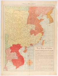
1519ref. 180794Chicago.: Chicago Daily Tribune. January 151942. Printed colour map on a single newspaper leaf 53 x 40.7 cm; 59.8 x 45 cm sheet inset text box marginal browning and at the folds but remarkably bright in very good condition. WWII map of China showing most of China Indo-China Thailand and Korea with territory captured and controlled by Japan shaded in orange and red published by the Chicago Daily Tribune barely six weeks after the bombing of Pearl Harbour. The text on the map reads "Since 1937 China has been at war with Japan. Lacking many essentials of war the Chinese nevertheless have managed to maintain a front against the aggressors. China's principal life line is the Burma road shown on the map which starts at Lashio Burma and extends to Kunming Yunnan province where it links with connections to Chunking the present Chinese capital". Based on a Rand McNally map the Tribune briskly got to work issuing maps for readers showing the beginnings of the war with Japan. Later maps were also published for sale separately but remarkably few have survived. "… the historic Chicago Tribune was an innovator in color inks and printing but also a pioneer in bringing colorful art in the form of illustrations photographs cartoons and advertisements to the average person in an everyday medium." see The Janet A. Ginsburg Chicago Tribune Collection Michigan State University Libraries. . Chicago Daily Tribune. unknown
1899554p. + Plus frontis and color folding map. Full page text half-tone engravings from photographs. Title page printed in red and black. Paper beginning to brown but not brittle. 4to. Original full cloth binding with pictorial design of British soldier, Boer soldier and an African tribesman. Binding slightly soiled. Nice copy. AFRICA/2
2003ref. x-1843424215Naval & Military Press Ltd 2003. Paperback. New. revised ed. edition. 66 pages. 9.53x7.24x0.24 inches. Naval & Military Press Ltd paperback
ref. 1843424215.Gpaperback. Good. Access codes and supplements are not guaranteed with used items. May be an ex-library book. paperback
1940ref. 318067New York: The Foreign Policy Association 1940. Pamphlet. 96p. stapled wraps 5.5x7.5 inches maps small stain on top edge of textblock else very good condition. Headline Books No. 23. The Foreign Policy Association unknown books
1986ref. 88234(Hamburg, Vermessungsamt, 1986. Mehrfach gefalt., mehrfarbige Landkarte, Maßstab 1:20.000. Blattmaß 68,5 x 101 cm.
Format: 63 x 100 cm (Blattgröße: 75 x 104 cm). Mehrfach gefaltet. *Seltene großformatige Wandkarte des römischen Reiches, offenbar von 2 großen Steinplatten gedruckt. - Die Falze teils mit hinterlegten Einrissen. Insgesamt in guter Erhaltung mit Rand. Bücher de
1958ref. 87000(Hamburg, Hamburger Sparkasse von 1827, 1958). 14 Bll. mit 12 doppelblattgr. Karten jeweils im Maßstab 1:50 000. Falzmaß 19 x 10 cm. .
1947ref. 23719München 1947. Maßstab: 1:50.000. Mehrfarb. Karte. 62 x 89 cm. Gefaltet. Faltmaß 16 x 12 cm.
1960ref. 88237Hamburg, Paul O. R. Grothe, [ca. 1960. Mehrfach gefalt. farbige Landkarte, Maßstab 1:50.000. Kartenmaß 50 x 73 cm, Blattmaß 52 x 75 cm. Deckelmaß 18 cm. In OKartumschlag geheftet.
1840ref. 848CG(um 1840). Kol. Aquatinta. Bildausschnitt: 7,2 x 11 cm. Rahmengrösse: 16 x 21 cm. + Wichtig: Für unsere Kunden in der EU erfolgt der Versand alle 14 Tage verzollt ab Deutschland / Postbank-Konto in Deutschland vorhanden +, Abb.
2014Book and jacket appear in as new unread condition. 246pp. A complete walk along the Border from Gretna to Lamberton, just north of Berwick on Tweed, filled with information on nature, literature, history and the people who lived there.
1844ref. 63111London: J.&C. Walker 9 Castle Street Published by Longman & Co. ca. 1844. 16mo. 3.5 x 5 in. folding out to 13.25 x 16.5 in. dissected 15-panel hand-coloured steel-engraved map linen-backed w/ 3 leaf folding population and mileage distance chart from Dublin by County mounted on front pastedown. Dark gray-green publisher’s cloth portfolio pocket binding decorative borders in blind gilt lettering stamped on front cover a NF copy. First edition thus of this very scarce dissected pocket map of Ireland published against the backdrop of the full impact of the Great Potato Famine which from 1841-1851 resulted in the diaspora and death of nearly 30% of the Irish population and as reflected in the mileage table mounted with the map the population in 1845 had already dropped from 8.2 million in 1841 to 7.7 million by 1844 and it would plummet further to below 6.5 million by 1851. The bulk of these emigrated to the United States Canada and the United Kingdom resulting in the fact that Ireland’s current population still resides below the high of 1841 and nearly 38 million Irish-Americans claim descent from the successive waves of migration much of which channeled through New York’s Lower East Side and the Bowery in the 19th-Century. John Walker 1787-1873 was a British mapmaker engraver lithographer hydrographer draughtsman and publisher publishing nautical charts and geographical maps with his brothers Charles and Alexander in their firm J.&C. Walker located at 9 Castle Street Holborn from 1841-1847 and moving to 37 Castle St. in 1848 where they remained to 1875. Much of their work was published under the auspices of the Society for the Diffusion of Useful Knowledge or S.D.U.K. Worldcat locates 1 copy Yale. J.&C. Walker, 9 Castle Street, Published by Longman & Co., hardcover
1839ref. 782121839. Longman Rees and Co. 1839. Early Edition. Hardback. No DW. Brown textured cloth. 9cm x 12.5cm. Linen-backed fold-out map in colour 35cm x 42cm . Ownership signature to inside cover. A lovely copy. hardcover
1921FIRST EDITION, TWO VOLUMES BOUND TOGETHER. This is a detailed survey of the city of Jerusalem during the start of the British Mandate in Palestine. Includes a large number of drawings, photographs, schematics and fold-out maps of the city, accompanied by essays in English and French. Editor Charles Ashbee was an architect, and paid close attention to the many religious edifices in the city. 285x230mm, XV+87+XVI+109 pages (only text pages are numbered). Brown Quarter-leather hardcover with large black illustration on front board. [CONDITION:] Cover edges and corners worn. Cover boards slightly dirty. Previous owner's inscription in Hebrew (dated 1969) on front endpaper. Some pages slightly age-stained. [SUMMARY:] This tandem-bound copy of a fascinating collection of textual and visual information is overall in very good internal condition; good external condition.
ref. 0008328072.Gmap. Good. Access codes and supplements are not guaranteed with used items. May be an ex-library book. unknown
1982No marks or inscriptions. No creasing to covers or to spine. A very clean very tight copy with bright unmarked boards and no bumping to corners. 107pp. Very concise details of six-hundred and twenty-five walks in Wales, including grid references and OS map numbers.
1 folded map. Good. Scale 4 miles = 1 inch. (BP touring service). 14644. eng
1995No marks or inscriptions. A lovely clean very tight copy with bright unmarked boards and no bumping to corners. Dust jacket not price clipped or marked or torn or creased with slight indenting to front. 216pp. Superbly illustrated guide to and descriptions of the Lake District mountains from A Wainwright. Tucked in is a guide to a walk from Clapham - Gaping Gill & Ingleborough.
1760ref. LBW-425Paris, Charpentier, [circa 1760]. 340 x 510 mm.