12.067 resultados
2004ref. 62366Berlin, Heidelberg : Springer (Classics in Mathematics), 2004. XXI, 254 S. (23,5 cm) Broschierte Ausgabe
1930ref. 2080502106910370Not Available 1930. Soft Cover. Fine. The book is in fine condition. Not Available paperback
1764(København, 1764). Kobberstukket prospekt af Det kgl. Teater. (17,5x24,5 cm.).
ref. 13188DBo.J. [2 Warenabbildungen] Tobias Conrad Lotter, geboren 1717, gestorben am 14. Juli 1777. Kupferstecher, Kartograph und Verleger in Augsburg.
1990204 pages. Index. Two fold-out maps. Many black and white illustrations. Topics include: The First People, Explorers, Pioneers, Nanoose areas, Biographies, The Community, The Next Decade (1980-1990) which provides some coverage of Fairwinds. Gift greetings inside front cover else unmarked. Light wear. A nice copy of this substantial work. Book
1980196 pages. Index. Two fold-out maps. Many black and white illustrations. Topics include: The First People, Explorers, Pioneers, Nanoose areas, Biographies, The Community. Moderate wear. Unmarked. A sound copy of this substantial work. Book
1991No marks or inscriptions. No creasing to covers or to spine. A very clean very tight copy with bright unmarked boards and no bumping to corners. 160pp. Some of England's finest examples of both natural and man-made scenery, photographed in colour by Rob Talbot and described from historical, geographical and natural perspectives by Robin Whiteman.
2003Book in mint condition. 200pp. History and description of the German Palace in Wurzburg between Frankfurt and Nuremberg, considered to be the most beautiful Palace in the country. Very well illustrated.
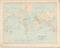
1853Carta del Mondo in proiezione mercatoriana, in due fogli, tratta dal Family Atlas. Questa mappa dettagliata presenta una notevole quantità di informazioni. Gli Stati Uniti sono mostrati escludendo il sud-ovest e il Texas. Il Texas è stato un paese indipendente dal 1836 al 1845, ma è mostrato qui come parte del Messico. Il confine settentrionale degli Stati Uniti e del Canada mostra il conteso confine per l'Oregon, scendendo fino a circa il 45° parallelo, che riflette le rivendicazioni britanniche in quella regione. La questione fu finalmente risolta nel 1846 con il trattato dell'Oregon che fissava quel confine al 49° parallelo. La regione artica mostra l'estensione delle conoscenze contemporanee, non notando nulla oltre al "Packed Ice" a nord dello stretto di Bering. L'Africa è mostrata con gran parte del suo interno non mappato - quella regione non è stata mappata a fondo fino all'ultima parte del XIX secolo. La Society for the Diffusion of Useful Knowledge, o SDUK, fu fondata nel 1826 per fornire informazioni scientifiche e di altro tipo alla classe media e ai lavoratori britannici. This delicately detailed map on two separate sheets presents a considerable amount of information. The United States is shown excluding the Southwest and Texas. Texas was an independent country from 1836-1845, but it is shown here as part of Mexico. The northern border of the United States and Canada shows the disputed border for Oregon Territory coming down to about the 45th parallel, which reflects British claims in that region. This was finally solved in 1846 with the Oregon Treaty fixing that border at the 49th parallel. The Arctic region shows the extent of contemporary knowledge, noting nothing besides Packed Ice north of the Bering Strait. Africa is shown with much of its interior left unmapped - that region was not mapped thoroughly until the latter part of the 19th century. An attractive an informative map surrounded with a keyboard style border. The Society for the Diffusion of Useful Knowledge, or SDUK, was established in 1826 to provide scientific and other information to the British middle and working classes. The Family Atlas was published by Society for the Diffusion of Useful Knowledge. The SDUK published several editions of its atlas. Dates I have seen quoted are 1829-32, 1840, 1844, and 1846. In 1848 the SDUK ceased to be active, but works which it had commissioned continued to be published.
1984198 pages. Features: Manuel Canovas; Lancut Castle; Mimi O'Connell; Zoodochos Pigi; John Standing; David Shilling; Roman Glass; 17th Century Maps; and more. Unmarked. Average wear. Binding intact. A sound copy. Magazine
1874ref. 174897London.: Virtue & Co. circa1874. Printed colour map 18.4 x 24.1 cm edge wear marginal spotting and on the verso but the map in very good condition. Unusual map showing time differences east and west of Greenwich before the atomic clock and well before satellites! The explanatory text notes aso that: "The space comprehended between the meridiens of 120 & 160 E. is repeated in order to show the relative position of England to Australia both eastward and westward." . Virtue & Co. unknown
1854Fifteen Volumes. Folding maps in volumes 3, 4, 8 and 10. Inked ownership of H.L. Smyser (of York, PA), Dec. 22, 1866 in all volumes. 190mm. Original full purple publisher's cloth bindings. Spines faded. Hardbound. Very good. Washington Irving (1783-1859) was an American author, essayist, biographer and historian of the early 19th century. He was best known for his short stories "The Legend of Sleepy Hollow" and "Rip Van Winkle", both of which appear in his book The Sketch Book of Geoffrey Crayon, Gent. Quite a nice set of this early edition. **PRICE JUST REDUCED! W58
1967ref. 32992set3Arno Press 1967-01-01. Hardcover. Good. All 3 volumes hardbound copies without jackets Arno Press 1967. Vol. 1 Vol. 6 of Bancroft's Works 1501-1530: bookplate inside front cover marks on back cover no text markings noted. Vol. 2 Vol. 7 of Bancroft's Works 1530-1800: bookplate inside front cover small marks on top edge no text markings noted. Vol. 3 Vol. 8 of Bancroft's Works 1801-1887: bookplate inside front cover no text markings noted. Arno Press hardcover
1973176 pages including index, bibliography and appendices. Black and white illustrations. Maps. "For months the Finns, who received scant help from an admiring world of sympathizers and avowed allies, held on. Yet the holding could only last until the Russians gathered themselves. When that happened and Red wheel-to-wheel artillery attacks and new hordes of troops and tanks again took their toll, the Finns bowed to the inevitable defeat... Describes the big picture and relates the stories of many individual Finns and Russians in combat. The result is a fascinating and moving book." - from dust jacket. Usual library markings. Above-average wear. Worthy reading copy. Book
1963ref. 055361New York: Mcgraw-Hill 1963. 1st Edition 1st Printing. Hardcover. Fine/Near Fine. 192 Pp White Spine Blue Cloth Covers Gilt. First Edition Indicated. Fine In Near Fine Dust Jacket Priced $10.00. Vine-Bordered Bookplate Of California Wine Expert Robert Lawrence Balzer. Mcgraw-Hill hardcover
1926Pages 86-168+ 20 pages of nice ads, including photo of Earle E. Liederman, "The Muscle Builder". Features: Mazulla and His Sahib, part 1 - moving Indian adventures, with photos; Neilson's New Man -a story of country life in New Zealand; The Tale-Teller of Algiers - the strange adventure of a visitor to Algiers in October, 1925; Mussolini's War Against the Mafia in Sicily - describes the first stage of the great 'clean-up' - a most dramatic and exciting business - article with photos of Police Commissioner Spano, Signor Mori of Palermo, Gaetono Ferrarello, Carmelo Andaloro, Salvatore Ferrarello, and Nicolo Andaloro; Mr. Stepper, I.D.B. - a diamond story; The Trouble in Coeur D'Alene - part 2 - going undercover to investigage labor-management conflict in the mining district of Northern Idaho - with photos; "Free-Trading" in the Arctic - great photo-illustrated article about white traders living in remote Indian and Eskimo territories; Photo of Korean wedding; One Thing After Another - troubles on the Inyoka Tobacco Estate in Rhodesia, with photo of author and trouble-making jackal; Across North America in a Motor-Boat, part 4 of this record-setting 6,000 mile trip - with maps and photos; The Cleverest Thieves on Earth - The Criminal Tribes of India - a photo-illustrated account of the 'crims' and their hereditary war against society. Above-average external wear. A worthy vintage copy. Book
1946Very slight foxing. No other marks or inscriptions. No creasing to covers or to spine. A very clean very tight copy with bright unmarked boards and no bumping to corners. 118pp. Things to do, places to see, literary connections, Nation Trust sites, hills, nature, gardens, museums, ancient residences etc.
1961pp. vii, 23 + Plus numerous drawings, maps and photographs of the excavation. 4to. Original printed blue wraps. Very good copy. First excavated by James Pritchard (1956-1962), Gibeon has significant archaeological remains - especially from the days of the early Israelites. First Edition. SCIENCE BOX 3
1987Twelve full-page colour prints in a rigid portfolio folder. Presentation plate to Tom Pendry (now Lord Pendry) inside front cover. No marks or inscriptions and no creasing to covers. Very clean prints in unmarked portfolio. 14pp. Photographic images of the USA Capital City including the White House, the Washington Monument, the Lincoln and Jefferson Memorials, the ceiling of the Capitol Rotunda, the Supreme Court building and the National Gallery of Art. Scarce in the UK.
ref. 2712New York : Konecky & Konecky 1965. 1965. Hardcover. Very Good/Very Good. 655 p. : ill. maps ; 24 cm. ; ISBN: 1568520271 ; OCLC: 32905083 ; grey textured cloth with gold lettering in colorful dustjacket ; spot on front cover ; spine creased else VG/VG New York : Konecky & Konecky, 1965. hardcover
1919Cover illustration of British soldier on skis in North Russia. Illustration of the French deliverers in Saverne (Zabert). War Reputations Lost and Won - article by Hamilton Fyfe. British Ships Against Bolshevism in the Baltic - 3 photos including the H.M.S. Calypso and Caradoc plus H.M.S. Angora and Wakeful. U Boat U44 Salvaged - 4 photos. Under the White Ensign in Kiel's Black Waters - 3 photos including the H.M.S. Hercules. Some of the Naval Inventions Employed in the War - article. Photos of the famous German Battle Cruiser Goeben. Two photos of Allenby and his men in Cairo. The Price in Blood and Treasure - article. Photo of earth removal at the base of the Vendome Monument in Paris. Several interesting photos of British mines and the mine-layer 'H.M.S. Wahine.' Four sensational photos of the Handley Page 'Giant'. How Paris & Dunkirk suffered by Bomb and Shell - two maps. Three photos of Holzminden, the worst camp of all. Hun Inhumanity to Helpless Men - some facts about German Prison Camps. Photos of Winners of the V.C. in the last weeks of the war. Demobilising the V.A.D.'s. Some soiling to covers. Average wear. Staples disintegrated. A sound copy. Book
1988No marks or inscriptions to contents. A very clean very tight copy with bright unmarked red cloth boards, discolouration to small part of upper rear corner and no bumping to corners. Dust jacket price clipped but not marked or torn or creased with general traces of storage. 256pp. Detailed guide to the Italian Lakes - Orta, Maggiore, Lugano, Como and Garda and the surrounding area. Well illustrated.
1987Ex library book with usual marks and stamps. Clean tight pages with bright unmarked tape-free red cloth boards and no bumping to corners. Dust jacket not price clipped or marked or torn with creasing. 231pp. An ideal detailed guide for the independent motoring traveller in Corsica.
New Haven-London, Yale University Press, 1965. Folio; XII-291 pp., con 24 reproducciones de mapas entre el texto y en láminas aparte, algunas de ellas plegadas. Encuadernación original en media tela. Un estudio fundamental sobre los orígenes de la debatida cartografía referente a Vinlandia y las expediciones a las costas americanas en el medievo.
1953ref. 309567NY: BALLANTINE BOOKS. Near Fine in Very Good dust jacket. 1953. First Edition. Hardcover. Near fine in a Vg. dj. Barely discernable 2"-inch tear at upper seam of rear panel of dj. A few short edge tears & small chips as well as traces of shelfsoiling to dj. Novel of the Virginia Calvary in the Shenandoah Valley during the Civil War. LR . BALLANTINE BOOKS. hardcover