1869réf. Le273London: Trubner & Co. 1869. 2nd Edition . Hardback. Fine. Oblong 4to. 26 Coloured plate maps engraved on copper each with a description. Original brown blind-stamped decorative borders gilt titles. head and tail of the spine rubbed otherwises a fine copy. Karl Spruner von Merz 1803-92 Trubner & Co. hardcover
1909réf. 014713Albany: University of the State of New York 1909. Original green cloth gilt is in Very Good condition. The book's inner hinges are badly cracked and nearly separated. However since the text block is secure entirely intact it could be easily re-cased without any re-sewing required. Thick 8vo. 234pp. 51pp. 66pp. 41pp. approx. 100 plates inserted. Complete with all of the maps as called for by the table of contents. A tough-to-find book especially complete with all the BEAUTIFUL MULTI-COLOR FOLDING MAPS IN PERFECT CONDITION. Any of them would look magnificent framed. This amazing miscellany contains the Fifth Report to the Director 1908 and Museum Bulletins 126-128 and 133 and Report of the State Paleontologist for 1908. A particularly useful contribution is: One Hundred Years of New York State Geologic Maps 1809-1909 by Henry Leighton. It includes a CARTO-BIBLIOGRAPHY that describes 329 New York Geologic Maps and has its own index. Some other contributions: A Peculiar Landslip in the Hudson River Clays by D. H. Newland; Some Items Concerning a New and an Old Coast Line of Lake Champlain by George H. Hudson; Types of Inliers Observed in New York by Rudolf Ruedemann; The Last of the Iroquois Potters by M. R. Harrington; etc. There are several other articles on the same subjects as and supporting the maps described below. Bound into Museum Bulletin 127 are NINE MULTI-COLOR FOLDING MAPS #34-42: showing 9 stages of Glacial Lake Succession in New York State 1908. In a pocket at the end are SEVEN BEAUTIFUL MULTI-COLOR FOLDING MAPS most by H. L. Fairchild as follows: Museum Bulletin 126: Geologic Map of the Remsen Quadrangles unfolds to 17" wide by 21" tall; Museum Bulletin 127: Plate 2: Channels and Deltas of Ice-Border Drainage between Leroy and Fishers 1906. 39" wide by 17.5" tall; Museum Bulletin 127: Plate 3: Channels and Deltas of Ice-Border Drainage between Irondequoit and Cayuga Valleys 1906. 39" wide by 20" tall; Museum Bulletin 127: Plate 4: Channels and Deltas of Ice-Border Drainage between Jordan and Chittenango Valleys 1906. 36" wide by 20" tall; Museum Bulletin 127: Plate 5: Channels and Deltas of Ice-Border Drainage between Chittenango and Oneida 1906. 17" wide by 12" tall; Museum Bulletin 128: Geologic Map of the Geneva-Ovid Quadrangles 17" wide by 38" tall; Museum Bulletin 128: East-West Section on Ovid and Genoa Quadrangles. Showing the Low Synclines of the Lake Basins. 17" wide by 8" tall. This copy has the small ink stamp of C. Wesley Yeakel in 4 places. First Edition. Hardcover. VG inner hinges cracked/No jacket. Illus. by Fairchild H. L. maps. Thick 8vo. University of the State of New York Hardcover
2000Very faint foxing to textblock else fine. ; 2 Volume Set; Vol. 1/2/2022; 13.1 X 10.1 X 4.5 inches; 1448 pages
1805réf. Map947Paternoster Row London: Longman Hurst Rees & Orme 1805. 1st Edition 1st Printing. No Binding. Fine. Folio - over 12 - 15" tall. Original early 19th century uncoloured MAP OF HINDOOSTAN BY AARON ARROWSMITH. A FINE CLEAN AND DARK IMPRESSION. Original folding plate covering THE WHOLE OF HINDOOSTAN printed on heavy paper dated 1808. A scarce example and in fine un-coloured original condition. An occasional light foxing mark. 41x27cms. Double-page folding map. engraved by J. Russell.A LOVELY COPY. paper watermark dated 1811 Longman, Hurst, Rees & Orme unknown
1806réf. Map943Paternoster Row London: Longman Hurst Rees & Orme 1806. 1st Edition 1st Printing. No Binding. Fine. Original early 19th century MAP OF THE WORLD On MERCATORS PROJECTION BY AARON ARROWSMITH. A FINE CLEAN AND DARK IMPRESSION. Original folding plate covering THE WORLD printed on heavy paper dated 1807. A scarce example and in fine un-coloured original condition. 41x27cms. Double-page folding map.A NICE COPY Longman, Hurst, Rees & Orme unknown
1839réf. TH327London: Longman Orme Brown Green & Longmans 1839. a new Edition Considerably Improved . Hardback. Vg. 8vo. ND but preface dated Walworth 1839. xxiv 364pp 7 folding plates at the rear.12pp pub. cat. dated August 1841 London. Bound in the pub. green fine pebble gren cloth with gilt titles to the spine. Pasted -down end-papers list Longmans 'New School Books'/ Neat owners sig. dated 1842. Thomas Keith 1759-1824. The first edition was pub. in 1805 Longman, Orme, Brown, Green & Longmans hardcover
1814réf. Map689Edinburgh: John Thomson 1814. No Binding. Fine. Original hand-colour fine scarce unfolded copy 520 X 650 From John Thomsons New General Atlas 1817 beautifully hand-coloured on thick paper John Thomson unknown
In 8° gr., br. edit., pp. XXVIII-558(6) con 5038 schede e 50 tavv. n.t. Indici delle località, degli artisti e delle sedi di calcografie, litografie e case editoriali.
1993COFANETTO IN FOLIO ( cm.46 X 34 ),IN TUTTA TELA RIGIDA AMARANTO CON TITOLO ENTRO ETICHETTA AL PRIMO PIATTO CONTENENTE 24 CARTE IN FACSIMILE ( cm.85 X 61 ) + v.r.a col. DI VARIE PARTI DELLA TOSCANA + 2 CARTE D'INSIEME ( 1 in b/n, e 1 a col. di cm.63 X 59 ), COMPILATE DAL MOROZZI TRA IL 1752 E IL 1784. COMPLETA L'OPERA, UN FASCICOLO DI pp.26 CON UN SAGGIO DI GIUSEPPE PANSINI E INDICE DEI NOMI A CURA DI MATTEO BARBARULO. FERDINANDO MOROZZI ( 1723 - 1785 ), ARCHITETTO, INGEGNERE E CARTOGRAFO TOSCANO. SI ERA FORMATO TRA SIENA E FIRENZE NELLE SCIENZE MATEMATICHE E NEL DISEGNO, AVEVA ESERCITATO LE MANSIONI DI MATEMATICO A BORDO DELLE GALERE DELL'ORDINE DI SANTO STEFANO E NEL 1749 ERA STATO IMBORSATO FRA GLI AIUTO INGEGNERI. A LUI FU ORDINATO DAL RICHECOURT DI FORMARE LA CARTA GENERALE DELLO STATO DEL GRANDUCATO DI TOSCANA . NEL 1770 PUBBLICO' UN TRATTATO SULLE CASE COLONICHE. COLLABORO' CON GIOVANNI TARGIONI TOZZETTI NELLA STESURA DELL'OPERA " VIAGGI FATTI IN DIVERSE PARTI DELLA TOSCANA ", REALIZZANDO LE CARTE DEL TERRITORIO DI PISA E DI LIVORNO. PRESTIGIOSA OPERA COMPLETA DELLE 24 CARTE + LE 2 D'INSIEME CHE SPESSO MANCANO. PERFETTA CONSERVAZIONE. MANTENUTO IL CONTENITORE DI CARTONE CON I TITOLI AL DORSO. ID, 4310
réf. 129605aafBern, Eidg. Landestopographie, 1915 - 29, in-8° (gefaltet), vollständig in 20 numm. gef. Karten. Aufdruck auf Titel-Umschlag Planquadrat’, Orig. Pappschachtel mit Rückentitel.
réf. 130268aafBern, Schweiz. Landestopographie, 1833 -1863, in-8° (gefaltet), Blatt 14 bis 25 auf Leinen aufgezogen, je mit einer Folge-Nr. versehen. O.-Lwdmappe .
réf. 558.1aaf(Amstelodami), Ioannes Ianßonius (1588-1664) ca. 1650, 34 x 50 cm Schöne teils handkolorierte Kupferstich-Karte von Strassburg, links unten Titel in Kartusche, rechts oben 2 heraldische Wappen, kleine Beschädigungen am Rand links unten, 1 Blatt.
réf. 127479aafIn Druck gegeben u. Verlegt Durch Matthaeum Merian. M.DC.XLII. (1642), in-4to, 72 S. (gest.(Kupfer-) Titelblatt inkl.) + 4 Bl. Namen Register. Exemplar ohne Kupfertafeln, Orig. Pergament-Einband, braunes Leder Titelschild am Rücken.
réf. 118961aafDietikon-Zürich, Verlag Bibliophile Drucke Josef Stocker, 1976, 52x65 cm. 4 S. Text, 1 faksim. Karte. Eines von 490 numm. Exemplaren (GA 530 Ex.). Ex. Nummer 90. Pappband-Mappe mit Leinen Rückenstreifen. (OHLn.-Mappe - Titelschild auf Umschlag vorne).
réf. 132195aafA Genève: faite chez B.M.C. (Barde Manget et Comp.) 1788, pliée pt. in-8vo (42.2 x 57.5 cm), carte coloriée.16 éléments montées sur toile au XVIIIè siècle, ex frais, carte pliée in-8°, étui d’époque, pièce de titre en maroquin rouge.
réf. 62443, K ln, Selbstverlag, 2000 softcovers 9 B nde. 4 , 21 x 29,5 cm, mit zahlreichen Abbildungen, illustrierter Original-Broschureinband mit Leinenr cken in sch ner Erhaltun.
First Edition, 5 vols., in 7 [all published], 4to, ex-library, orig. cloth, d.w's. Vol. 1. Voyages and Travel. 1968. Illustrs., 2 maps, 428pp. Vol. 2. Biography. 2 Parts, 1971. Illustrs., 1196pp. Vol. 3. Atlases & Cartography. 2 Parts, 1971. Illustrs., 1166pp. Vol. 4. Piracy & Privateering. 1972. Illustrs., 175pp. Vol. 5. Naval History. Part 1: [All Published] The Middle Ages to 1815. 1976. 12 plates, 209pp.
First and only edition, [2], vi, 37,[1] + 2pp., of adverts, orig. printed blue boards with white paper spine, the spine is worn with some loss to the original cover at base, some brown damp staining to lower inner margins which correspond with the damage to base of spine, partly unopened, uncut. A good acceptable example of this very rare work which was bought out to accompany Henry Price's New Map of the County of Hereford which is advertised at the rear of the book. Copac listing a single copy at Cardiff University Libraries.
1650Very Good Latin Original map. Oblong 4to. (25 x 34,5 cm). In Latin. From 'Mercator Atlas'. A very good copy. A detailed and decorative engraved map. B/w. Including Europae Pars (Thrace) and Black Sea, Aegean and Mediterranean, and with all ancient toponyms and names of regions including Cyprus and Syriae (Syria). Could not be find map-maker and being from which book. An early and decorative map of Asia Minor.
1851Bella pianta di Torino in b.n. (cm. 46,3 x 54,5), telata e suddivisa in 18 riquadri. Sul lato destro superiore figurano gli elenchi dei “primarj alberghi, chiese parrocchiali, primarj stabilimenti”. Su quello inferiore: “Popolazione della Città di Torino a sei differenti epoche (dal 1794 al 1850)”. Ben conservata.
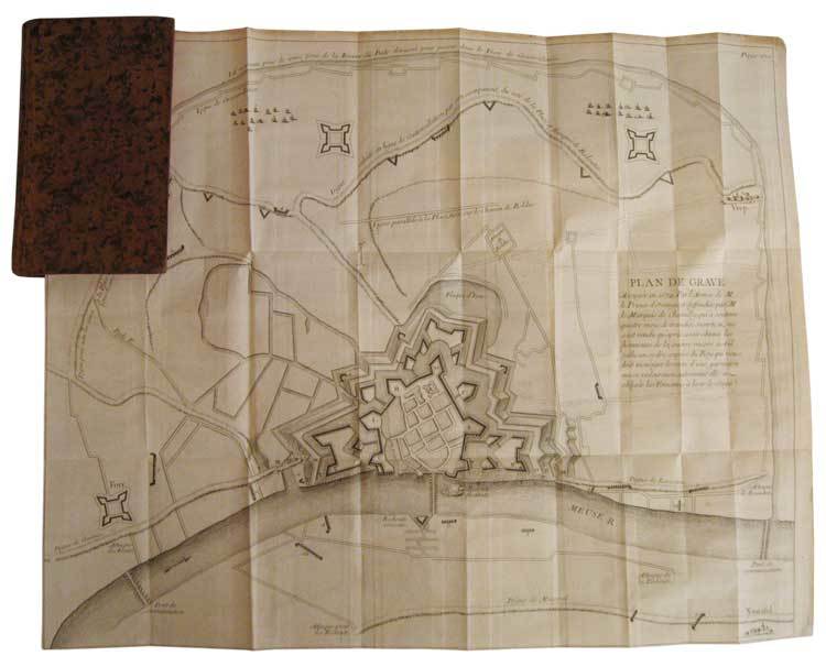
réf. 34837Paris, C.A. Jombert, 1756. In-12, plein veau marbré de l'époque, dos lisse orné de compartiments cloisonnés et fleuronnés, pièce de titre de maroquin bordeaux, tranches rouges, xii, 356 p. et (4) p. d'approbation et privilège, 2 très grands plans dépliants hors texte.
In-12, plein veau marbré de l'époque, dos lisse orné de compartiments cloisonnés et fleuronnés, pièce de titre de maroquin bordeaux, tranches rouges, xii, 356 p. et (4) p. d'approbation et privilège, 2 très grands plans dépliants hors texte. Première édition collective illustrée de 2 très grands plans dépliants des villes de Grave et Mayence. En juillet 1674, les Hollandais mirent le siège pendant 93 jours devant Grave dans le Brabant-Septentrional, ville occupée par les français depuis 1672. Les pertes furent considérables des deux côtés. Fin octobre, le gouverneur de la place, le marquis de Chamilly, reçut l’ordre du roi de se rendre. Ce qui restait de la garnison défila devant l’armée hollandaise qui lui rendit les honneurs et le Prince Guillaume III d'Orange récupéra la ville le 28 octobre 1674. Le siège de Mayence se déroula du 1er juin au 8 septembre 1689, pendant la guerre de la Ligue d’Augsbourg. "Récit méthodique, composé par un témoin oculaire. Exposé par ordre chronologique. Correct, froid, très détaillé et très utile" (Sources de l’Histoire de France, n° 3973). Petite étiquette imprimée à l’époque de la librairie Cellot et Jombert, "Rue Dauphine, la seconde porte cochère à droite par le Pont-Neuf, au fond de la cour". Bel exemplaire, frais, très bien relié à l’époque.
Augsburg, 1808. Incisione in rame, colore d’epoca, cm 52 x 62 (alla lastra). La mappa comprende anche una dettagliata descrizione del sud est asiatico e dell’estremo oriente. Carta un po’ brunita, due pieghe trasversali e alcuni strappetti marginali ma in buono stato.
Francia, 1732 - 1746 circa. Tratta dal “Recueil de plusieurs plans des ports et rades et de quelques cartes particulières de la mer Mediterranee" par Jacques Ayrouard pilote Real avec privilege du Roy. Incisione in rame all'acquaforte, b/n, cm 31 x 46,5 circa (alla lastra) più margini. Disegnata dal Ayrouard e incisa dal Corne, piano del Porto di Savona; si segnalano scandagli, pericoli per la navigazione e ancoraggi che si trovano lungo la costa. Poco si sa su Jacques Ayrouard, il quale pubblicò solo questo libro sui porti del Mediterraneo. Era un navigatore per la Marina Reale francese e dedicò il suo lavoro a Jean Federico Phélypeaux Comte de Maurepas, che fu Ministro della Marina per Luigi XV. Un punto di ossidazione in alto, leggermente spostato sulla sinistra, leggero sfondo di inchiostratura, peraltro foglio in ottimo stato di conservazione.