ADMINISTRATION PREFECTORALELivre Rare Book

6 304 résultats
1925réf. 235In -8, reliure souple de percaline verte, tranches rouges, 319 p. Imprimerie administrative, Charles-Lavauzelle & Cie, (1925) .
1815réf. 11Draguignan de l'Imprimerie de Fabre 1815-1820 6 tomes en 5 vol. in-4 (les tomes 1 et 2 reliés en un volume), dos lisses ornés, le premier volume relié en demi basane à petits coins vélin, mors fendillés, coiffe sup. émoussée; les 4 autres volumes reliés en demi basane à petits coins vélin également, mais légèrement différente du premier volume, et en excellente condition. (Reliures de l'époque).
1885réf. 2111902160201161Kamiina Nagano Prefecture 1885. Soft Cover. Fine. Volume: 1 Kamiina, Nagano Prefecture paperback
1969réf. 2080502106510103Japan Ceramic Society 1969. Soft Cover. Fine. Volume: 1 Japan Ceramic Society paperback
1919réf. 2110502150410123Nagoya Branch of the Imperial Japanese Military Association 1919. Soft Cover. Fine. Number of copies: 1 copy Nagoya Branch of the Imperial Japanese Military Association paperback
1985réf. 2080602108200984``Buraku Liberation Fundamental Law'' Requested by Nagasaki Prefecture Implementation Committee 1985. Soft Cover. Fine. The book is in fine condition. ``Buraku Liberation Fundamental Law'' Requested by Nagasaki Prefecture Implementation Committee paperback
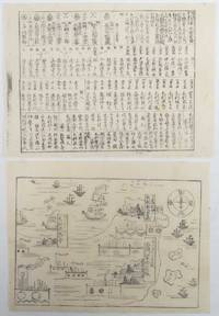
1865réf. 214219Japan. No date. Circa1865. Two small black and white woodblock kawaraban prints 22 x 29cm. Some worming but generally good. These two kawarabans showcase the Mōri family who held dominion over Chōshū in western Japan for more than 250 years. In the first kawaraban the main castle of Lord Mōri in Hagi along with smaller territories in Fuchu and Tokuyama are depicted featuring illustrations of their castles and residences. Sea surrounds their territories with their boats and other ships visible on the water. The second sheet provides a comprehensive list of the members of the Mōri family and their followers detailing their names and the levels of their earnings. Nearly one hundred names are listed providing insight into the structure and hierarchy within the Mōri family and its associated domains. These kawarabans offer valuable historical insights into the Mōri family's influence and organization during their reign over Chōshū. . unknown
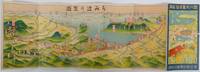
1920réf. 222913Japan.: 讃岐遊覧電鉄連合会. Sanuki Yūran Dentetsu Rengōkai. Circa1920s. Colour folding bird's-eye view map map 15.2 x 45.5cm fold into 15.3 x 7.8cm reverse a little time toned very good condition. A Japanese guide to the Sanuki region of Kagawa Prefecture in Shikoku featuring an attractively coloured bird's eye map probably published in the 1920s. The map shows the part of the Seto Inland Sea nearest to Sanuki's main city - Takamatsu - as well as the road and rail links to the region and the nearby Kotohira Temple - a major site of pilgrimage. The Japanese text on the back of the map includes a small sketch map of the local sightseeing railway showing distances between stops and the prices of fares and information about the best routes around the area including details of the Sanuki's cable cars. The cover features a charming illustration of a seaside temple in spring surrounded by cherry blossoms. . 讃岐遊覧電鉄連合会. [Sanuki Yūran Dentetsu Rengōkai]. unknown
réf. 8537P., Lottin de Saint-Germain, (1819). In 4 de 11 pp.
réf. 45734, Paris, Impr. municipale, Hôtel de Ville 1972, in-8, br., impression sur papier glacé, (couverture fanée), intérieur frais, 259p.
1903réf. 28735NANTES PORT-SAY [ACTUELLEMENT Marsa Ben M'Hidi - Commune en Algérie ] 1903 1 photographie albuminée en noir, format : 11 x 8,2 cm, (vue animée), PHOTOGRAPHIE ORIGINALE : NANTES 14 JUIN 1903 - EXPULSION DES PERES PREMONTRES - DEVANT LA PREFECTURE APRES LE PASSAGE DES MANIFESTANTS : DEBRIS DE GUERITES (TRES ANIMEE),
1903réf. 28736NANTES PORT-SAY [ACTUELLEMENT Marsa Ben M'Hidi - Commune en Algérie ] 1903 1 photographie albuminée en noir, format : 11 x 8,2 cm, (vue animée), PHOTOGRAPHIE ORIGINALE : NANTES 4 MAI 1903 - EXPULSION DES PERES PREMONTRES - LA FOULE DEVANT LES GRILLE DE LA PREFECTURE ( ANIMEE),
1892réf. 170411No details of publisher. Circa1892. 2 volumes. Volume I: Two leaves with black and white line illustrations showing a uniform 583pp prior owner's seal on first leaf. Volume 2: Folding table at rear variously paginated over 600 pages prior owner's seal on cover. Some light occasional soiling and corners trifle creased. Wrappers with string ties. These two thick volumes were published in the 1890s probably by Mie prefectural government for managing their prison system. The volumes give details of all the rules and legislation relating to prisoners and prison guards. They offer rare historical information on the Japanese prison system in the late 19th century at the time when Japan was in the process of westernisation. The prison system and related legislation was set up in Meiji Japan and followed two European systems French and German. Until 1900 prisons were run by both local and central governments when their management was transferred to the central government. These 2 volumes were published by Mie Prefectural government prior to the transfer to central government and reflect the local system as it was before transition. The Japanese prison system to this day is well known for its strict and detailed rules and regulations. The first of these volumes covers the treatment daily schedules and inspections of prisoners as well as the handling prisoners with infectious diseases. The volume also lists numerous regulations relating to prison guards' work. The second volume is a collection of relevant rules and legislation on prison and prisoner handling. An important detailed resource for anyone interested in the prison system in the late 19th century. We have been unable to find this handbook in any institutional holdings. . No details of publisher. unknown
1925réf. 27269Toulon Raffaelli 1925 Une gravure Originale (Grande Carte) en couleurs sur papier cartonné souple, format : 42,5 x 15 cm, signé en bas à droite dans la gravure : H. Gervèse, fait partie d'une Série d'ensemble : "NOS MARINS" : N°1 - Le Bal à la Préfecture Maritime, sans date (1925)Toulon Raffaelli Editeur,
1990réf. _202100987S. l. (Nancy), S. é. (Préfecture de Mthe-et-Mlle, s.d. (vers 1990) ; A4, 11-275 ff., couverture et feuilles collées, dos muet. Les 2 volumes. Revue de Presse du 29 mai 1988 au 18 décembre 1989. Nombreuses illustrations en noir et blanc.
réf. 201702280A Colmar, Chez la veuve DECKER, imprimeur de la préfecture, 1833 ; petit in-4, 222 pp., cartonnage de l'éditeur. En bon état - dix huitieme année complète texte sur 2 colonne (une en francais et une en allemand).
1978réf. 2082702114908192Kochi Prefecture Planning Department Regional Promotion Division 1978. Soft Cover. Fine. Number of pages: 241 pages Size: 26cm Kochi Prefecture Planning Department Regional Promotion Division paperback
1971réf. 2082702114905138Promotion of depopulation measures in Kochi Prefecture 1971. Soft Cover. Fine. Number of pages: 197 pages Size: 25cm Promotion of depopulation measures in Kochi Prefecture paperback
1992réf. 2080202106300708Kumamoto Prefecture Board of Education 1992. Soft Cover. Fine. Size: 26cm Kumamoto Prefecture Board of Education paperback
1974réf. 2082702114907447Mono fumei 1974. Soft Cover. Fine. Number of pages: 952 pages 8 pages size: 27cm Mono fumei paperback
1975réf. 2080502106406431Saga Prefecture Reclamation Association 1975. Soft Cover. Fine. Number of pages: 10 10 475p Saga Prefecture Reclamation Association paperback
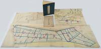
1880réf. 220946Japan. Circa1880. Coloured bird's eye view map 38.3 x 52cm with original envelope somewhat worn folded colour map with neat washi repairs to the verso 39.2 x 127.7cm black and white diagram 28.2 x 52.8cm colour illustrated book 27.7 x 20cm 28 double-folded leaves four hole string binding title label on front cover with minor chips. Covers discoloured and worn but holding firmly internally bright and clean. This collection of three historical maps one diagram and an original envelope offers a detailed view of land use and planning in the Tsu’u region of Okayama Prefecture during the early Meiji period. The area had a long history of human habitation with fertile soil and abundant water sources. From the beginning of the Edo period in the 17th century land in the area was progressively reclaimed leading to an expansion of agricultural land. The collection comprises the following five items: Detailed Map of Hayashima Shinden Village in Tsu’u County Bitchū 備中國都宇郡早嶋新田村明細地圖 Land Division Map untitled in Japanese Diagram of Natsukawa Village Primary School in Tsu’u County Okayama 備中國都宇郡撫川村小學校見取繪圖 Pictorial Map of Additionally Registered Lands 地積追番雛形繪圖 Original envelope with title Item 1 shows the divisions of rice-growing land in Hayashima Shinden Village with area measurements and registration numbers. Water channels are coloured in blue. Item 2 is a large map showing land divisions in an adjacent area of Hayashima although it does not have a title. Item 3 is a diagram of a primary school established in Natsukawa at the beginning of the Meiji period probably in the 1870s. An existing Buddhist temple and its compound were used for the school. The diagram identifies a fenced school yard pupils’ entrances to the classrooms at the rear and a flagpole standing beside the school gate. Item 4 is a beautifully drawn bird’s-eye view map showing a settlement with a temple and shrine along a river surrounded by mountains forests and rice paddies. Item 5 is the original envelope titled Hayataka Village Map and most likely belongs with Item 4. . unknown
1953réf. 853371953 Valence, Imprimerie Céas, 1953, in 8° broché, V-210 pages ; cartes et nombreuses planches illustrées hors-texte.
1984réf. 2082702114900357Motoyama Town Board of Education 1984. Soft Cover. Fine. Number of pages: 32 pages Size: 26cm Motoyama Town Board of Education paperback
1973réf. 2080502107002237Saga Prefecture Board of Education 1973. Soft Cover. Fine. Number of pages: 33 pages Map size: 22 cm Saga Prefecture Board of Education paperback