Estrada, Rodrigo VelizBiblio.com
3 389 résultats
réf. 51824217-nnew. unknown
réf. 52120541-nnew. unknown
réf. 0749528834-11-1Automobile Association. Very Good. It's a well-cared-for item that has seen limited use. The item may show minor signs of wear. All the text is legible with all pages included. It may have slight markings and/or highlighting. Automobile Association unknown
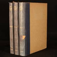
1950réf. 996W42London and Beccles: The International Road Federation 1950-1956. Hardback. Very Good Indeed. 11.5" by 8.5". Not Stated. An incredibly scarce collection of richly illustrated magazines published by the International Road Federation. A scarce collection of 3 volumes featuring numerous issues of this publication which was released twice a year.All three volumes feature a great number of vignette monochrome illustrations illustrations with colour detail and contemporary advertisements.Volume 1 features 1 double sided monochrome plate and frequent vignette illustrations in both colour and monochrome.Volume 2 features a tipped in plate welcoming Sir Donald St. Clair Gainer to the role of Chief Executive in 1951.Including an article on the 'coronation route' used by the newly-crowed Queen Elizabeth II and a feature on the Golden Gate Bridge.No other collation record available. Rebound in half cloth. Externally smart. Slight fading to spines. Light marks to vol2 rear cloth. Moderate damp staining to vol3 boards. Light scuffing to vol3 rear board. Slight chipping and rubbing to board extremities. Small pieces of tape to vol1 and 3 spines. Library stamp to front endpapers and tipped-in library bookplates to vol1 and 3 front endpapers. Internally firmly bound. Pages generally bright and clean. Slight spotting to text block edges. Very Good Indeed The International Road Federation hardcover
réf. DADAX140946525XNew unknown
2001réf. SBBIH-YINW6BNWTB5FAutomobile Association 2001. map. Good. Our good condition books are generally good for reading but not for gifting or collecting. They could have imperfections such as creasing fanning inscriptions margin notes yellowing staining on edge or cover or pages bumps scuffs etc etc sometimes multiple of these. It's a wide category that encompasses anything that isn't almost-new down to anything that is slightly better than poor. We would NOT recommend gifting Good books - these should be considered reading copies. Our books are dispatched from a Yorkshire former cotton mill. We list via barcode/ISBN so please note that the images are stock images and may not be the exact copy you receive furthermore the details about edition and year might not be accurate as many publishers reuse the same ISBN for multiple editions and as we simply scan a barcode or enter an ISBN we do not check the validity of the edition data when listing. If you're looking for an exact edition please don't order at least not without checking with us first although we don't always have time to check. We aim to dispatch prompty the service used will depend on order value and book size. We can ship to most countries see our shipping policies. Payment is via Abe only. Automobile Association unknown
réf. DADAX1560259914New unknown
réf. DADAX113842661XNew unknown
réf. DADAX076560793XNew unknown
réf. SONG0367195267Used: Good unknown
1584réf. 64215Antwerp.: Abraham Ortelius. circa1584. Two engraved maps on laid paper each 30.3 x 19.5 cm printed on the one sheet 48 x 60 cm original fold attractive hand colour with related French text on verso slight toning and spotting to the margins but the maps in very good condition preserved in a modern window mount. Attractive maps of the German coast published in Ortelius' great atlas "Theatrum Orbis.". The left-hand map showing the mouths of the Elbe complete with sea monster and Eider Rivers and the coast of Schleswig-Holstein; the right-hand map of the Baltic coast with the Pomeranian islands of Rugen and Usedom. . (Abraham Ortelius). unknown
réf. DADAX1568995164New unknown
réf. SONG1847725651Used: Good unknown
réf. SONG1368023126Used: Good unknown
réf. SONG0528860518Used: Good unknown
1996réf. 2092902143902049Shunju-sha 1996. Soft Cover. Fine. Number of books: 1 book Shunju-sha paperback
1996réf. 2092902143802085Shunju-sha 1996. Soft Cover. Fine. Number of books: 1 book Shunju-sha paperback
réf. DADAX1880985764New unknown
2007réf. D6B0005893BookSurge Publishing 2007-05-25. Paperback. Like New. A beautiful copy. Text in mint/unmarked condition. Cover has minor shelf rubbings. Binding is tight. BookSurge Publishing paperback
réf. SONG1780763565Used: Good unknown
réf. DADAX0801857341New unknown
2004réf. x-0826469736T&t Clark Ltd 2004. Hardcover. New. 281 pages. 9.25x6.25x0.75 inches. T&t Clark Ltd hardcover
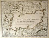
1723réf. 54819Rainer Ottens. 1723. A most attractive map with early outline hand colour vertical fold barely visible diagonal crease upper half of map few very pale small brown spots otherwise a clean and bright image. Numbering in red pencil few annotations in pencil and light number stamp on reverse however not at all visible from front of map or affecting image. Sheet measures 46.6 x 60.2cm. . Rainer Ottens. unknown
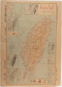
1945réf. 215871Taiwan.: 禹甸圖書局. Yudian tushuju. 1945. 1945 Ministry of Interior map of Taiwan published in the 34th year of the Republic of China with inset title and key top right. Romanised Japanese names for some areas and cities written in capital letters on main map which is surrounded by 15 small inset maps at edges each with its own scale. Paper browned wear at folds and edges repaired with archival washi on reverse some light stains and a few marks. 1 x 3cm chip bottom right corner. 77.4 x 54 cm. Text in traditional Chinese characters. Inset maps show clockwise from right edge; 1. Distribution of inhabitants according to ethnic background or minority group 2. Qing Dynasty prefectures and counties 3. Japanese administrative regions during the occupation 4. Strategic industrial and military places three city maps - 5.Chilung or Keelung port 6. Taipei city and 7. Tainan city 8. Geological formations 9. agricultural metallurgical and mineral products 10. Soil types 11. Topography of the island including sea currents and altitude diagram 12. Taiwan's position in relation to the mainland coast provinces of Fujian and Zhejiang as well as the Liuqiu Ryukyu Islands including Okinawa 13. Okinawa detail 14. Climate and rainfall in January 15. Climate and rainfall in July. . 禹甸圖書局. [Yudian tushuju]. unknown
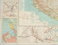
1962réf. 174808Kuala Lumpur.: Survey Department Federation of Malaya. 1962. Very attractive large coloured folding map 108 x 83cm showing all the major hotels and rest houses throughout the country. Coloured references show rubber rice coconut and oil palm areas pineapple and miscellaneous cultivation areas mining land jungle built-up areas and shopping centres along with major features such as rivers principal roads minor roads and cart tracks railways lighthouses district state and international boundaries and triganometrical stations with heights. Scale 18 miles to an inch mile. Two inset maps of Northern Malaya and South Western Malaya are 9 miles to an inch. There are smaller inset maps of Ipoh; Malacca Singapore & Johor Bahru Penang Sungei Patani Kuala Lipis Kuantan Alor Star Kota Bharu Petaling Jaya Seremban Klang Batu Pahat Muar Segamat Johore Bahru and a small inset map of Malaya and adjacent territories. There is a large black & white table of approximate mileages. When folded the map is encased in the original printed manila covers measuring 21 x 14cm with a printed price of $2.50. A crisp bright map in very good condition. Survey Department Federation of Malaya No. 23. . Survey Department Federation of Malaya. unknown