4.360 Ergebnisse
Best.-Nr. 35674-nnew. unknown
1584Best.-Nr. 64215Antwerp.: Abraham Ortelius. circa1584. Two engraved maps on laid paper each 30.3 x 19.5 cm printed on the one sheet 48 x 60 cm original fold attractive hand colour with related French text on verso slight toning and spotting to the margins but the maps in very good condition preserved in a modern window mount. Attractive maps of the German coast published in Ortelius' great atlas "Theatrum Orbis.". The left-hand map showing the mouths of the Elbe complete with sea monster and Eider Rivers and the coast of Schleswig-Holstein; the right-hand map of the Baltic coast with the Pomeranian islands of Rugen and Usedom. . (Abraham Ortelius). unknown
1996Best.-Nr. 2092902143902049Shunju-sha 1996. Soft Cover. Fine. Number of books: 1 book Shunju-sha paperback
1996Best.-Nr. 2092902143802085Shunju-sha 1996. Soft Cover. Fine. Number of books: 1 book Shunju-sha paperback
2007Best.-Nr. D6B0005893BookSurge Publishing 2007-05-25. Paperback. Like New. A beautiful copy. Text in mint/unmarked condition. Cover has minor shelf rubbings. Binding is tight. BookSurge Publishing paperback
2004Best.-Nr. x-0826469736T&t Clark Ltd 2004. Hardcover. New. 281 pages. 9.25x6.25x0.75 inches. T&t Clark Ltd hardcover
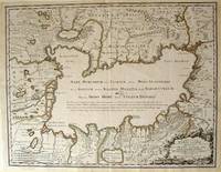
1723Best.-Nr. 54819Rainer Ottens. 1723. A most attractive map with early outline hand colour vertical fold barely visible diagonal crease upper half of map few very pale small brown spots otherwise a clean and bright image. Numbering in red pencil few annotations in pencil and light number stamp on reverse however not at all visible from front of map or affecting image. Sheet measures 46.6 x 60.2cm. . Rainer Ottens. unknown
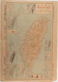
1945Best.-Nr. 215871Taiwan.: 禹甸圖書局. Yudian tushuju. 1945. 1945 Ministry of Interior map of Taiwan published in the 34th year of the Republic of China with inset title and key top right. Romanised Japanese names for some areas and cities written in capital letters on main map which is surrounded by 15 small inset maps at edges each with its own scale. Paper browned wear at folds and edges repaired with archival washi on reverse some light stains and a few marks. 1 x 3cm chip bottom right corner. 77.4 x 54 cm. Text in traditional Chinese characters. Inset maps show clockwise from right edge; 1. Distribution of inhabitants according to ethnic background or minority group 2. Qing Dynasty prefectures and counties 3. Japanese administrative regions during the occupation 4. Strategic industrial and military places three city maps - 5.Chilung or Keelung port 6. Taipei city and 7. Tainan city 8. Geological formations 9. agricultural metallurgical and mineral products 10. Soil types 11. Topography of the island including sea currents and altitude diagram 12. Taiwan's position in relation to the mainland coast provinces of Fujian and Zhejiang as well as the Liuqiu Ryukyu Islands including Okinawa 13. Okinawa detail 14. Climate and rainfall in January 15. Climate and rainfall in July. . 禹甸圖書局. [Yudian tushuju]. unknown
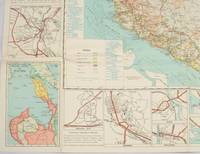
1962Best.-Nr. 174808Kuala Lumpur.: Survey Department Federation of Malaya. 1962. Very attractive large coloured folding map 108 x 83cm showing all the major hotels and rest houses throughout the country. Coloured references show rubber rice coconut and oil palm areas pineapple and miscellaneous cultivation areas mining land jungle built-up areas and shopping centres along with major features such as rivers principal roads minor roads and cart tracks railways lighthouses district state and international boundaries and triganometrical stations with heights. Scale 18 miles to an inch mile. Two inset maps of Northern Malaya and South Western Malaya are 9 miles to an inch. There are smaller inset maps of Ipoh; Malacca Singapore & Johor Bahru Penang Sungei Patani Kuala Lipis Kuantan Alor Star Kota Bharu Petaling Jaya Seremban Klang Batu Pahat Muar Segamat Johore Bahru and a small inset map of Malaya and adjacent territories. There is a large black & white table of approximate mileages. When folded the map is encased in the original printed manila covers measuring 21 x 14cm with a printed price of $2.50. A crisp bright map in very good condition. Survey Department Federation of Malaya No. 23. . Survey Department Federation of Malaya. unknown
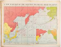
1942Best.-Nr. 206849Chicago.: Chicago Daily Tribune. 28 January1942. Printed colour map 40.3 x 53.6 cm; 46.5 x 60 cm sheet inset map of the North Pacific back cover from a section of the Chicago Daily Tribune newspaper pages 21-34 January 28 1942; central fold edgewear and browning with a few minor tears not affecting the map in very good condition. Based on a Rand McNally map and issued less than two months after the bombing of Pearl Harbour by the Japanese. The Tribune briskly got to work issuing maps for readers showing the beginnings of the war with Japan. Later maps were also published for sale separately but remarkably few have survived. The map shows "the nearness of our Aleutian Island chain west of Alaska to the islands of Japan. At Dutch Harbor and other points in the Aleutians are actual and potential sea and air bases lying on the shortest route from northwestern United States to Japan." The inset map at lower right situates the areas in the larger map in respect to the countries bordering the North Pacific Ocean. Included with the map is the complete newspaper section from which it is the final full page. Covering sport and the market with half a dozen popular comic strips including "Dick Tracy" and "Little Orphan Annie" it shows a domestic United States a world away from what had been seen as a European War. ". the historic Chicago Tribune was an innovator in color inks and printing but also a pioneer in bringing colorful art in the form of illustrations photographs cartoons and advertisements to the average person in an everyday medium." see The Janet A. Ginsburg Chicago Tribune Collection Michigan State University Libraries." . Chicago Daily Tribune. unknown
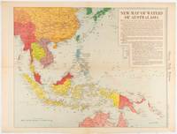
1619Best.-Nr. 180757Chicago.: Chicago Daily Tribune. December 161942. Printed colour map on a single newspaper leaf 41.6 x 52.8 cm; 45 x 60 cm sheet inset legends marginal browning and at the folds but remarkably bright in very good condition. Map of Southeast Asia published in the Chicago Daily Tribune "The World's Greatest Newspaper" delineating the Pacific theatre of war with a detailed text legend. "This is a new war map of the far east showing an important part of southeastern Asia and Australasian waters from a station in which according to Prime Minister Curtin of Australia a United States fleet will operate." Interestingly New Guinea is marked as British rather than as an Australian administrative region which it became following the Treaty of Versailles. "… the historic Chicago Tribune was an innovator in color inks and printing but also a pioneer in bringing colorful art in the form of illustrations photographs cartoons and advertisements to the average person in an everyday medium." see The Janet A. Ginsburg Chicago Tribune Collection Michigan State University Libraries. . Chicago Daily Tribune. unknown
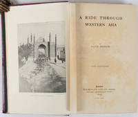
1897Best.-Nr. 176109London.: Macmillan and Co. Limited. 1897. Photographic frontispiece of 'The Shah returning to Teheran' and numerous full page photographic illustrations four folding printed colour maps marginal spotting xii 275 pages 23 x 15 cm original red glazed red cloth boards occasional spotting the cloth a little marked and flecked the spine sunned but in very good condition. An extensive and intrepid modern Grand Tour account through Constantinople and Turkey to Persia and Central Asia with 34 striking photographic plates. Clive Bigham was an Honorary Attaché to the British Embassy at St. Petersburg and war correspondent in the Near East travelled at the very height of the Armenian troubles when the strict orders had been issued by Turkey that Asia Minor was to be closed to Europeans. Burrell 94. This item is held off-site. Please note there may be a few days delay while it is brought into our shop for viewing or mailing to you. Thank you for your understanding. When referring to this item please quote stockid 176109 . Macmillan and Co. Limited. hardcover
Best.-Nr. BN370452The Milwaukee Road in Color Vol. 5: Pacific Extension 1941-1961 Hardcover The Milwaukee Road in Color Vol. 5: Pacific Extension 1941-1961 Hardcover The Milwaukee Road in Color Vol. 5: Pacific Extension 1941-1961 Hardcover hardcover
Best.-Nr. 13090Dating from between 1965 and 1981. Six addressed to 'Edward'; five to 'Teddy'; one to 'Eddy; one to 'Edouard'; one to 'Cher amis' and one to 'Dear Roger'. Totalling 22pp. 4to; 11pp. 8vo; 2pp. 12mo. Ten of the fifteen letters are dated the other six having only month and year. With copies of two typed letters to Ceccaldi from Edward one from 1973 in English 1p. 4to and the other from 1980 in French 2pp. 8vo the latter accompanied by a synopsis of Ceccaldi's 'The Flight of Icarus' with a foreword by him and a biography the three items totalling 4pp. 8vo; also manuscript notes 1p 8vo; 3pp. 12mo. Also present is a newspaper cutting from Le Figaro 13 October 1969 with a photograph featuring Ceccaldi. The letters are detailed friendly and businesslike with Ceccaldi discussing plays and translations 'The Rivals. J'aime beaucoup beaucoup la piece.' distribution pricing the differences between the English-speaking and French-speaking theatres and providing contact details and other information. On 19January 1973 he writes: 'J'ai lu la traduction de ce monsieur Jack Palmer White que je connais d'ailleurs: ce'st une folle anglaise ou américaine dont tout le monde dans le théatre parisien se méfie parce qu'il est collant et sans talent.' The letter to Roger dated 20 May 1972 begins unfortunately: 'Dear Roger I'm really guilty. I received two letters from you a copy of "Jack in the box" et sic two cassetts sic one month ago. and I didn't yet answer you. I'm so sorry. I am very busy in French one says "I'm working like a negro" but now negroes don't work any more and I used to look for an instance to write to you. Now I prefer to write in French because I am afraid with my poor English and I need to be perfectly clean. Please ask Teddy to translate my letter.' Ceccaldi's first leading role in films was in 1954 playing Henri d'Anjou opposite Jeanne Moreau in La Reine Margot. Other successes included the two Truffaut films Baisers Volés and Domicile Conjugal. Dating from between 1965 and 1981. unknown
2024Best.-Nr. x-3031504690Springer Nature 2024. Hardcover. New. 109 pages. 10.98x8.27x0.47 inches. Springer Nature hardcover
1972Best.-Nr. 2090202122600218Not Available 1972. Soft Cover. Fine. The book is in fine condition. Not Available paperback
Best.-Nr. 2092902141800180Uemura Jiroemon N.A. Soft Cover. Fine. Number of books: 1 Uemura Jiroemon paperback
1998Best.-Nr. DADAX0471977136Wiley 1998-06-29. 1. hardcover. New. 6.22x0.63x9.25. Buy with confidence. Excellent Customer Service & Return policy. Wiley hardcover
2008Best.-Nr. x-0387787046Springer Verlag 2008. Hardcover. New. 1st edition. 547 pages. 10.00x7.00x1.25 inches. Springer Verlag hardcover
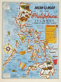
1945Best.-Nr. 204557U.S.A.: Mem-O-Map Co. 1945. Colour pictographic / pictorial map 32.1 x 23.8 cms; 35.4 x 26.6 cms sheet very good condition. Rare pictorial map published in 1945 by John G. Drury aTechnical Officer who served with the 214th Ordnance Battalion to mark the end of World War II as souvenirs for the military. Military personnel could fill in banners "came in on good ship." and "departed on good ship." their name organisation and "Line of Advance or movement" blank in this example. Pictographs mark various memorable spots and wildlife including larger-than-life insects. A "Terrible Tillie Typhoon" looms over the coast at Luzon. Drury published a series of five maps: Philippines and Okinawa in 1945; Japan and Korea Oahu and Europe in 1946. They are all scarce. “These almost whimsical maps are designed to support the creation of personalised geographies. At a time when digital mapping is beginning to experiment with the creation of personalised content that would render the same map in different ways for different users Mem-O-Maps demonstrate the principle in action." Kenneth Field ICA Commission on Map Design. . Mem-O-Map Co. unknown
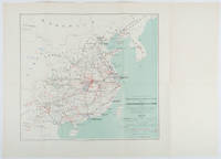
1898Best.-Nr. 214719Paris.: Erhard Frères. 1898. Lithographed folding colour map 44.5 x 49.5 cms; 54.6 x 76.3 cms sheet towns and cities items of production and trade routes highlighted in red original folds in very good clean condition. Detailed map prepared for the Lyon Chamber of Commerce Mission to China under the direction of a young Henri Brenier 1867-1962 with the purpose of advancing French colonial expansion and shoring up the interests of the dominant Lyon silk trade. The map shows the principal centres of population production waterways roads telegraph lines and railroads togther with the centres of production and distribution for coal iron tin gold and silver opium tea rice sugar peanuts cinnamon wool medicinal plants and leather. The trade mission was organized following the Treaty of Shimonoseki and the end of the Sino-Japanese War: the Chamber of Commerce of Lyon understood that end of this war would signal a profound economic development and change. . Erhard Frères hardcover
Best.-Nr. 35674like new. unknown
194435 pages. Photo and bio details of Bond inside front cover. Four pages of wonderful photos of Bond with the Andrews Sisters, Max Terhune, Jimmy Wakley, Dick Reinhart, The Red River Valley Boys, Joan Davis, Ray Corrigan, and Dennis Moore. "Gene Autry invited Johnny and Jimmy Wakely to sing with him on his CBS Melody Ranch program and soon the whole of America began to join the others in the demand for more. Songs include: I Wonder Where You Are Tonight; Down in the Dumps; One More Range; You Never Can Tell; I've Had the Blues Before; Keep Rollin' On; It's a Long Old Road; Prairie Campfire; Out Here The Wind Blows Free; One More Tear; Here's The End of the Trail (Ole Timer); Old Wagon Train; One a Blue Ridge Mountain Trail; The Road is Way Too Long; I'm Pounding the Rails Again; The Unopened Letter; I Won't Stand in Your Way; Hillbilly Town; My Red River Rose; Don't You Weep Anymore, Darlin'; Oh, My Darling Clementine. Average wear. Some light pencil markings to contents. A sound copy of this marvelously nostalgic item. Book
1944Pages 645-672. Features : Cover portrait of Churchill upon his 70th birthday; Great one-page photo of Princess Elizabeth launching a battleship (location and ship name not provided, presumably for wartime reasons); Two pages of statistics of Britain's war effort; One-page Karsh photo-portrait of Edward Stettinius, U.S. Secretary of State; Two-page illustration of how L/Sergeant John Daniel Baskeyfield won his Victora Cross (V.C.) during the battle of Arnhem; Six photos show the opening of the port of Antwerp - a great supply port for the Western Front; Photos of incidents on the Western Front involving British, U.S. and French troops; Photo of captured Major-General Faterrodt, Commander of the German garrison in Strasbourg; Centerfold illustrations by G.H. Davis show the 'works' of the V-2 rocket bomb - some details of the driving system of a German 'revenge' weapon; Sevenphotos from the battlefields of Burma - on the road to Mandalay, including contour map of the Burma Front; Two photos of devastation after huge underground explosion at R.A.F. depot near Burton-on-Trent; Two photos of German explosive motor boats; Two drawings of the northern lights over arctic convoys, by Commander R.E.D. Ryder, V.C.; Photo of first Norwegian troops marching into liberated Kirkenes; Photo of German radio-controlled glider bomb released from the air to attack shipping; Two large photos of the British Home Guard Stand-down before the Royal Family in London; Photos of personalities of the week include F.A.M. Browning,Wing-Cdr. Guy Gibson, V.C. (of 'Dam-Busters' fame), Sir Eric Teichman, Viscountess Astor (photo taken with a large group of women at the Commons, General Eisenhower with Sir M. Dempsey and Lt.-General Ritchie, M.T. Arciszewski, Havildar Maj. C. Ram, V.C., Captain R.K. Dickson, Montgomery's personal staff - J.R.B. Durrant, N.W. Chavasse, T. Warren, Lt.-Col. Dawnay, J.R. Henderson; nostalgic ads; and more. This copy was never stapled. Unmarked. Somewhat above-average wear. Coverfold taped. A worthy vintage copy. Book
1918Features: Title page illustration of British despatch-rider delivering Christmas pudding by bicycle in deep snow; G.K. Chesterton makes the case that the English are ignorant; One-page aerial photo of French tanks attacking a German trench-line; Excellent photo of hundreds of "China's Army of Labourers for the Western Front - A Big Muster on Parade"; Two pages of illustrations show the difficulties faced by British patrols in nocturnal search of German North Sea raiders; Three pages provide ten photos of the aftermath of the terrible Halifax explosion on December 7th, 1917; One-page portrait of Admiral Sir Rosslyn E. Wemyss; Two photos show the difficulty of transportation after recent French snow; One-page aerial photo of French bombs raining down upon a German munition factory in Lorraine; Two-page illustration of the breaking of the Hindenburg Line near Cambrai with Ulster and Yorkshire troops advancing on Bourlon Wood and crossing the Bapaume-Cambrai Road; Two-page illustration of British troops moving forward to the River-front Line; Two-page illustration of brilliant infantry work by the Italian Army on the Northern Front; Eight photos on two pages illustrate the British victorious advance in Palestine - hoisting the flag at Jaffa, and other scenes;Two half-page photos show the restoration of a water well in Palestine which was blown up by the Turks; Article on the impending shortage of food; and more. 36 pages, including seven pages of charming vintage ads, most of which are illustrated. In particular, the back cover ad for "Harlene Hair-Drill" will fascinate anyone interested in early women's hair treatments. Unmarked with moderate wear. Binding intact. A sound copy of this excellent WWI-era issue. Magazine