4 388 résultats
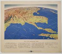
1944réf. 200808Remington Rand. 1944. Five printed colour maps each: 31.4 x 47 cms; 46.3 x 53.3 cms sheet central fold marginal edge wear chips and a few small edge tears tidemark affecting the ocean at the outer edge of Map VII but all the maps in very good condition. From a series of World War II battlefront maps "for the delight of arm-chair strategists" published by the Library Bureau of Remington Rand seven were published. Taken from a bird's eye view of the globe and with relief artistically rendered by artist Kenneth Thompson 1907-1996 and descriptive text by George Fielding Eliot 1894-1971. Eliot spent his youth in Australia attending Melbourne University serving with distinction in the Australian Infantry in WWI. Moving to the United States after a short stint in Canada serving with the RCMP her served as a reserve officer in the U.S. Army reserve in military intelligence from 1922 to 1933 and during WWII Eliot famously broadcast the first extended television coverage following the attack on Pearl Harbor. He continued to write books and articles about military strategy and world politics into the 1960s. In keeping with the "aviation-age" cartography of Richard Edes Harrison the unusual perspective of the maps--from above and often with a direction other than north at the top of the map--challenges the viewer to reconsider the geopolitical situation with the text of Eliot as a further prompt his captions below: Map III Italy & South France "Hannibal Caesar and Napoleon made their reputations here" Map IV The Western Front "Will the cockpit of 1918 see the decisive battles of 1944" Map V Southeastern Asia "The road to Mandalay -- and to China --along which bombs for Tokyo must travel" Map VI The Southwest Pacific "Island-hopping toward Japan -- in short and long hops" Map V11 The North Pacific "Here the enemy trusts in the protection of vast ocean distances" . Remington Rand. unknown
1926Roy. 8vo., First Edition, with a coloured frontispiece (original tissue guard present), and 167 illustrations by the author in the text; handsomely bound in dark red full morocco, back gilt with raised bands, gilt from original upper board and backstrip preserved and mounted on new and separate leaves, a most attractive copy ideal as a gift or for presentation. A lovely copy
2004réf. DADAX0826469736Continuum 2004-06-15. hardcover. New. 6.14x0.69x9.21. Buy with confidence. Excellent Customer Service & Return policy. Continuum hardcover
1987réf. 2080302106809575Nagasaki City Civil Engineering Department Road Maintenance Section 1987. Soft Cover. Fine. Number of pages: 136 pages Size: A4 version Nagasaki City Civil Engineering Department Road Maintenance Section paperback
réf. 35055-nnew. unknown
réf. 6366785John Wiley & Sons . Hardback. New. pp. 392 John Wiley & Sons hardcover
réf. 14471Memorandum: 17 June 1910. Receipt by Campbell: on letterhead of The Acacias Brooks Road Gunnersbury W. London. 8 July 1910. Letter by Langford: on letterhead of The Lisle Press Ltd. 24 Whitcomb Street Pall Mall. 17 June 1910. The collection consists of four items. All four in good condition on lightly-aged paper with slight creasing. ONE: Typed Memorandum. 3pp. foolscap 8vo. Signed over a stamp by Campbell and witnessed by Florence Campbell of Newcastle-on-Tyne. Campbell agrees to teach Langsford 'how to prepare the photographic paper called "Gelatino-chloride glossy printing-out paper" by the same formula and process as he uses and put him in the way to start and carry on a business for himself'. Further to this end he describes five actions he will take beginning with drawing up 'a plainly written copy of the formula along with instructions for the mixing and preparation . stating the ingredients used and the exact quantities required also plain directions how to coat and finish off the paper guaranteeing under a penalty of One Hundred Pounds that such formula and directions shall be in every respect precisely the same as used by him'. He will also give Langsford lessons at his home in Gunnersbury: 'How to mix the formula for preparing the P.O.P. then how to coat and finish off the paper and how to pack it for sending to customers; how to cut up and send away small samples with circulars by post to photographer and others and to be generally and fully instructed in everything necessary to enable him to commence and carry on a business for himself as a preparer of the photographic paper known as P.O.P.' TWO: Typed Receipt signed by 'Leonard Langsford' 17 June 1910. 'Herewith agreement duly signed as promised which I think meets the case. Kindly initial alterations. I enclose also cheque for £6. for plant.' Campbell acknowledges receipt by signing over a stamp at the foot of the page. THREE: Autograph Receipt signed by Arthur Campbell 8 July 1910. Acknowledging receipt of £25 from Langsford 'as set forth in agreement dated June 17th 1910'. FOUR: Autograph Letter Signed to Langsford from '<Kate> Reilly'. 1p. 12mo. Without date or place. Acknowledging receipt of a 'cheque £3/-/- on account'. It is not clear whether Arthur Campbell of Gunnersbury was the son of Alfred S. Campbell 1840-1912 the noted English-born photographer and inventor based in New York and proprietor of Campbell Studios there and in London. Memorandum: 17 June 1910. Receipt by Campbell: on letterhead of The Acacias, Brooks Road, Gunnersbury, W. [London]. 8 July 1910. unknown
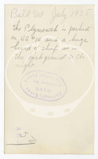
1935réf. 152267N.p.: N.p. 1935. Archive of 24 vernacular photographs documenting a 1935 summer road trip through the badlands of South Dakota Idaho and Wyoming. Each photograph with manuscript ink annotations identifying location to the margins and manuscript pencil annotations to the verso noting locations and dates along with the stamp of Rays photography studio in LaCrosse WI. Captured in the archive are various natural landmarks including Shoshone Canyon IXL Ranch and Bighorn Mountains in Wyoming Bald Mountain in Idaho and the Black Hills Badlands and Missouri River in South Dakota. Also included are a few photographs taken along US Route 14 one of the original US highways of 1926 an east-west route running 1398 miles. An alternately charming and chilling collection of Depression-era travel photography in the Midwest and Mountain West. 23 photographs 4.5 x 2.17 inches 1 photograph 3.5 x 2.75 inches. Generally Very Good plus some with light fading and age toning. N.p. unknown
1935réf. 152267N.p.: N.p. 1935. Archive of 24 vernacular photographs documenting a 1935 summer road trip through the badlands of South Dakota Idaho and Wyoming. Each photograph with manuscript ink annotations identifying location to the margins and manuscript pencil annotations to the verso noting locations and dates along with the stamp of Rays photography studio in LaCrosse WI. Captured in the archive are various natural landmarks including Shoshone Canyon IXL Ranch and Bighorn Mountains in Wyoming Bald Mountain in Idaho and the Black Hills Badlands and Missouri River in South Dakota. Also included are a few photographs taken along US Route 14 one of the original US highways of 1926 an east-west route running 1398 miles. An alternately charming and chilling collection of Depression-era travel photography in the Midwest and Mountain West. 23 photographs 4.5 x 2.17 inches 1 photograph 3.5 x 2.75 inches. Generally Very Good plus some with light fading and age toning. N.p. unknown books
réf. 6498741John Wiley & Sons . Hardback. New. pp. 208 John Wiley & Sons hardcover
réf. Bloomsbury-9781475874594Bloomsbury Academic. Hardback. New. 200 pages Bloomsbury Academic hardcover
réf. Bloomsbury-9781475874594Bloomsbury Academic. Hardback. New. 200 pages Bloomsbury Academic hardcover
réf. Bloomsbury-9781666969566Bloomsbury Academic. Hardback. New. 192 pages Bloomsbury Academic hardcover
réf. Bloomsbury-9781666969566Bloomsbury Academic. Hardback. New. 192 pages Bloomsbury Academic hardcover
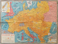
1944réf. 206781Toronto.: C.C. Petersen. 1944. Colour pictorial map 51 x 67 cm two small inset maps of Scandinavia and the Baltic and South Greece and the Dodecanese on the verso a black and white world map showing the Pacific Theatre marking keys events of the war and in European world history folding into the original pictorial pocket a little toned and marked 25.8 x 17.7 cm small fold split but in very good condition. A scarce map in the "Dated Events" series published by C.C. Petersen in Canada and distributed throughout North America commemorating D-Day. The colour map by Stanley Turner encompasses the area from England as far south as the French border with Spain and as far east as the USSR and Turkey. "With this invasion map you will be able to follow the progress of the Allied troops on their way to smash Germany.". The text at lower left goes on to elaborate on the features shown on the map from elevation "major battles are seldom fought on the tops of mountains" to pictographs of bombs falling. The black and white map on the verso shows the Far Eastern theatre of war centring on the Pacific Ocean with the Asian landmass including India and the USSR at upper left Australia at lower left and North America and the coast of South America at right of the map. Naval bases are shown and significant events in the war are noted in text boxes. A handsome production of a scarce map rarely seen with the original pictorial pocket. . C.C. Petersen. unknown
2016réf. x-1138124761Routledge 2016. Hardcover. New. 299 pages. 9.25x6.25x0.75 inches. Routledge hardcover
1986réf. Q-9061935431Springer 1986-06-30. Hardcover. New. New. In shrink wrap. Looks like an interesting title! Springer hardcover
réf. 2080202106701096Not Available N.A. Soft Cover. Fine. The book is in fine condition. Not Available paperback
réf. 25024978-nnew. unknown
réf. 51824217-nnew. unknown
réf. 52120541-nnew. unknown
1920Vintage 1920 New York State road map. 24" x 18.75". Somewhat tender with several openings at fold lines and junctures through use. Two faint contemporary ink stamps on back panel. Average wear. Back side provides city maps for New York City, Buffalo, Rochester, Utica, Syracuse, Brooklyn and Binghamton. A worthy copy of thiis wonderfully nostalgic item. Book
1944réf. 004015Paris Denoël 1944 In-8 Broché, couverture rempliée
réf. 15053Paris, Gauthier-Villars, 1903-1904 ; in-8 ; bradel demi-percaline ocre foncé, pièce de titre de maroquin rouge à grain long (reliure de l'époque) ; VI, 264 pp., (1) f. d'errata, (1) f. blanc, 138 figures ; (4), 307 pp., 3 cartes hors-texte, 159 figures.
réf. 36706Paris. Aux Editions Pierre Roger. 1932. 2 volumes grand in-4. Rel. Demi-Basane à coins. Pièces de titre aux dos. Très nombreuses photographies en N&B. et cartes dépliantes dans les 2 volumes. 448 p. et 843 p. Très bon état malgré des rousseurs. Reliures légèrement frottées.