Juan-Diego EstradaBiblio.com

4426 risultati
rif. Bloomsbury-9781475874594Bloomsbury Academic. Hardback. New. 200 pages Bloomsbury Academic hardcover
rif. Bloomsbury-9781666969566Bloomsbury Academic. Hardback. New. 192 pages Bloomsbury Academic hardcover
rif. Bloomsbury-9781666969566Bloomsbury Academic. Hardback. New. 192 pages Bloomsbury Academic hardcover
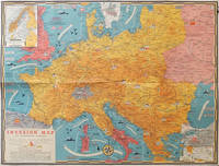
1944rif. 206781Toronto.: C.C. Petersen. 1944. Colour pictorial map 51 x 67 cm two small inset maps of Scandinavia and the Baltic and South Greece and the Dodecanese on the verso a black and white world map showing the Pacific Theatre marking keys events of the war and in European world history folding into the original pictorial pocket a little toned and marked 25.8 x 17.7 cm small fold split but in very good condition. A scarce map in the "Dated Events" series published by C.C. Petersen in Canada and distributed throughout North America commemorating D-Day. The colour map by Stanley Turner encompasses the area from England as far south as the French border with Spain and as far east as the USSR and Turkey. "With this invasion map you will be able to follow the progress of the Allied troops on their way to smash Germany.". The text at lower left goes on to elaborate on the features shown on the map from elevation "major battles are seldom fought on the tops of mountains" to pictographs of bombs falling. The black and white map on the verso shows the Far Eastern theatre of war centring on the Pacific Ocean with the Asian landmass including India and the USSR at upper left Australia at lower left and North America and the coast of South America at right of the map. Naval bases are shown and significant events in the war are noted in text boxes. A handsome production of a scarce map rarely seen with the original pictorial pocket. . C.C. Petersen. unknown
2016rif. x-1138124761Routledge 2016. Hardcover. New. 299 pages. 9.25x6.25x0.75 inches. Routledge hardcover
1986rif. Q-9061935431Springer 1986-06-30. Hardcover. New. New. In shrink wrap. Looks like an interesting title! Springer hardcover
rif. 2080202106701096Not Available N.A. Soft Cover. Fine. The book is in fine condition. Not Available paperback
rif. 25024978-nnew. unknown
rif. 51824217-nnew. unknown
rif. 52120541-nnew. unknown
1920Vintage 1920 New York State road map. 24" x 18.75". Somewhat tender with several openings at fold lines and junctures through use. Two faint contemporary ink stamps on back panel. Average wear. Back side provides city maps for New York City, Buffalo, Rochester, Utica, Syracuse, Brooklyn and Binghamton. A worthy copy of thiis wonderfully nostalgic item. Book
1944rif. 004015Paris Denoël 1944 In-8 Broché, couverture rempliée
rif. 15053Paris, Gauthier-Villars, 1903-1904 ; in-8 ; bradel demi-percaline ocre foncé, pièce de titre de maroquin rouge à grain long (reliure de l'époque) ; VI, 264 pp., (1) f. d'errata, (1) f. blanc, 138 figures ; (4), 307 pp., 3 cartes hors-texte, 159 figures.
rif. 36706Paris. Aux Editions Pierre Roger. 1932. 2 volumes grand in-4. Rel. Demi-Basane à coins. Pièces de titre aux dos. Très nombreuses photographies en N&B. et cartes dépliantes dans les 2 volumes. 448 p. et 843 p. Très bon état malgré des rousseurs. Reliures légèrement frottées.
193748 pages. Cover illustration by Eric Aldwinckle shows dapper tourist inspecting totem pole. Contents: Short article with photo on North American drought - photo shows sand drifts two to five feet high on the road allowance at Kisbey, Saskatchewan, 4 June, 1937; Uncommon full-page ad for Nesbitt, Thomson & Company - Gold Prospecting Theme; Parcker Vacumatic Pen Ad; The Man Who Was Careful - story by Elmer Davis; Via the North Pole - Air Commodore H. Hollick-Kenyon on what Russia's trans-polar flights mean to the future of aviation - with photos and map; The Road Never Dies, story by Bruce Hutchison; Television Broadcast, by Thomas Wayling - a layman's description of how the new wonder of the air works its miracle - with photos; Beverley Baxter on What's Happening in Europe; - with photos of Von Ribbentrop and The Leipzig; Yellow Cargo - story by Gordon Carroll; How's Your I.Q., by R.E. Knowles, Jr.; No More Bad Men - Dink Carroll writes about Rabbit Maranville, Manager of the Montreal Royals - with photo; Murder in Amber - story by Colver Harris; Animal Anecdotes - Fighting Turtles, by Phil H. Moore; Cigarettes, by Frederick Edwards - article with many great photos of cigarette production; Palmolive Soap ad features the Dionne Quintuplets; Full-page black and white Maxwell House Coffee ad bears the caption "What a Gay Dog You Are!" - as a woman dressed as Cleopatra chides her sullen husband dressed as a clown; Page of wonderful ads for thirteen private schools, including photo-illustrated ad for Ontario Ladies' College; Quarter-page photo ad for the Canadian National Exhibition's Coronation Year; Lovely half-page four-photo ad for Quaker Puffed Wheat featuring Shirley Temple; Article on How to Ice a Cake, by Helen G. Campbell; Lovely colour ad for Westinghouse radios on back cover features violin-maker Antonio Stradivari; Many more vintage ads. Moderately above-average wear. Address label atop front cover. Unmarked. Binding intact. A sound copy of this great issue. Book
195188 pages. Features: Humourous cover art by Oscar Cahen; The Censorship that Helps the Enemy - The bad events of March 17, 1951 in the Korean War involving the Princess Patricias - Editorial; There'll Always Be a Massey - Canada's most famous family started on the road to wealth from a tiny implement forge near Port Hope, Ontario - article with photos; You Laughed at My Father - story by James Aldridge; The Hottest Square Mile in the World - under the humpland between Ace Lake and Beaverlodge lies an abundance of Uranium, and here Uranium City will be built - article with photos; The West Coast's Worst Disaster - The Tragedy of the Princess Sophia which disappeared off Vanderbilt Reef and took 343 people to their deaths in icy Alaskan waters - a Maclean's flashback; How to Raise Ten Kids in Six Rooms - Frank and Helen Teskey of Toronto have ten kids under fifteen and they'd welcome more; One-Man Powerhouse - John Deagle of Whitefish Falls, Ontario runs his own electric power company! - article with many photos of this incredible man; Sherbrooke, Quebec - where French and English share a city in harmony - nostalgic article with photos; The Battle to Beat Leukemia - doctors search for a cure; Footlights Round My Heart - story by Ronald R. Smith; Sensational full-page colour Coke ad features illustration of young lady and the caption "Want Something Good?"; Nice colour Chevrolet ad; DeSoto car ad; Full-page ad for Birks Jewellers features watches including the Challenger Eterna-matic; Plymouth car ad; Canada Savings Bond ad features James F. Johnston, Superintendant of Palm Dairies Limited in Regina; Great colour photo Caterpillar ad inside back cover shows horses pulling vintage auto through the mud. Light wear. Unmarked. Center page loose but present. A quality copy. Book
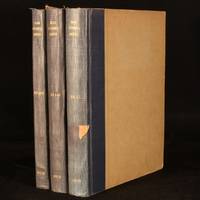
1950rif. 996W42London and Beccles: The International Road Federation 1950-1956. Hardback. Very Good Indeed. 11.5" by 8.5". Not Stated. An incredibly scarce collection of richly illustrated magazines published by the International Road Federation. A scarce collection of 3 volumes featuring numerous issues of this publication which was released twice a year.All three volumes feature a great number of vignette monochrome illustrations illustrations with colour detail and contemporary advertisements.Volume 1 features 1 double sided monochrome plate and frequent vignette illustrations in both colour and monochrome.Volume 2 features a tipped in plate welcoming Sir Donald St. Clair Gainer to the role of Chief Executive in 1951.Including an article on the 'coronation route' used by the newly-crowed Queen Elizabeth II and a feature on the Golden Gate Bridge.No other collation record available. Rebound in half cloth. Externally smart. Slight fading to spines. Light marks to vol2 rear cloth. Moderate damp staining to vol3 boards. Light scuffing to vol3 rear board. Slight chipping and rubbing to board extremities. Small pieces of tape to vol1 and 3 spines. Library stamp to front endpapers and tipped-in library bookplates to vol1 and 3 front endpapers. Internally firmly bound. Pages generally bright and clean. Slight spotting to text block edges. Very Good Indeed The International Road Federation hardcover
1584rif. 64215Antwerp.: Abraham Ortelius. circa1584. Two engraved maps on laid paper each 30.3 x 19.5 cm printed on the one sheet 48 x 60 cm original fold attractive hand colour with related French text on verso slight toning and spotting to the margins but the maps in very good condition preserved in a modern window mount. Attractive maps of the German coast published in Ortelius' great atlas "Theatrum Orbis.". The left-hand map showing the mouths of the Elbe complete with sea monster and Eider Rivers and the coast of Schleswig-Holstein; the right-hand map of the Baltic coast with the Pomeranian islands of Rugen and Usedom. . (Abraham Ortelius). unknown
1996rif. 2092902143902049Shunju-sha 1996. Soft Cover. Fine. Number of books: 1 book Shunju-sha paperback
1996rif. 2092902143802085Shunju-sha 1996. Soft Cover. Fine. Number of books: 1 book Shunju-sha paperback
2007rif. D6B0005893BookSurge Publishing 2007-05-25. Paperback. Like New. A beautiful copy. Text in mint/unmarked condition. Cover has minor shelf rubbings. Binding is tight. BookSurge Publishing paperback
2004rif. x-0826469736T&t Clark Ltd 2004. Hardcover. New. 281 pages. 9.25x6.25x0.75 inches. T&t Clark Ltd hardcover
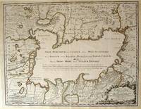
1723rif. 54819Rainer Ottens. 1723. A most attractive map with early outline hand colour vertical fold barely visible diagonal crease upper half of map few very pale small brown spots otherwise a clean and bright image. Numbering in red pencil few annotations in pencil and light number stamp on reverse however not at all visible from front of map or affecting image. Sheet measures 46.6 x 60.2cm. . Rainer Ottens. unknown
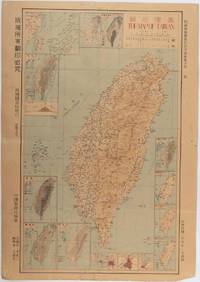
1945rif. 215871Taiwan.: 禹甸圖書局. Yudian tushuju. 1945. 1945 Ministry of Interior map of Taiwan published in the 34th year of the Republic of China with inset title and key top right. Romanised Japanese names for some areas and cities written in capital letters on main map which is surrounded by 15 small inset maps at edges each with its own scale. Paper browned wear at folds and edges repaired with archival washi on reverse some light stains and a few marks. 1 x 3cm chip bottom right corner. 77.4 x 54 cm. Text in traditional Chinese characters. Inset maps show clockwise from right edge; 1. Distribution of inhabitants according to ethnic background or minority group 2. Qing Dynasty prefectures and counties 3. Japanese administrative regions during the occupation 4. Strategic industrial and military places three city maps - 5.Chilung or Keelung port 6. Taipei city and 7. Tainan city 8. Geological formations 9. agricultural metallurgical and mineral products 10. Soil types 11. Topography of the island including sea currents and altitude diagram 12. Taiwan's position in relation to the mainland coast provinces of Fujian and Zhejiang as well as the Liuqiu Ryukyu Islands including Okinawa 13. Okinawa detail 14. Climate and rainfall in January 15. Climate and rainfall in July. . 禹甸圖書局. [Yudian tushuju]. unknown