Huet (Pierre-Daniel ; 1630-1721) :Livre Rare Book

5.466 Ergebnisse
1763Best.-Nr. 20307Lyon, Benoit Duplain, 1763 (marque gravée au titre) ; in-8 (200 mm), veau marbré, dos à nerfs décoré et doré, pièce de titre grenat, tranches rouges (reliure de l’époque) ; XXIV, 496 pp.
Best.-Nr. 650067Very Good. Softcover. Circa 1855. No title page -- appears to be assembled collection of bird plates from various U.S.P.R.R. Exp. & Surveys publications bound into a nice three-quarter leather album. Contains 31 linen-backed color plates. Most plates are not identified by species. All plates are Birds: California Plates II III IV V VII 2 plates with slight variation in background VIII 2 plates with slight variation in background; Cal & Oregon Plate IX; 32nd Parallel West Plates IV VI XIV; 32nd Parallel East Plates XV XXXI; 35th Parallel Plates XIV XX XXVII XXX XXXIII XXXVI; 38th-39th-41st Parallels Plates XII 2 identical plates XIII XVII XXXII XXXV; 47th Parallel Plates XI XVI; 47th-35th Parallels Plate XVIII 2 identical plates; 47th-32nd Parallels Plate XXVIII. Plates are very good. The covers show some rubbing spotting but binding is generally very sound and attractive. ; Trade PB; Oblong Small 4to 9" - 11" tall . paperback
Best.-Nr. 9781608766048NOVA SCIENCE PUBLISHERS INC
Best.-Nr. SONG091552032XRoss Erikson 0000-00-00. First English Soft Cover Edition. paperback. Used: Good. 0.00x0.00x0.00. Buy with confidence. Excellent Customer Service & Return policy. Ross Erikson paperback
1969Approximately 50 pages. Many fold-outs. This large 15" x 12" work presents the master plan for Erin Mills. "A fortunate combination of circumstances should make Erin Mills New Town a singular community. First, the company had the foresight and resources to acquire a tract of land in excess of ten square miles in one of the most favourable growth regions on the continent. Secondly, there exists a strong demand in this region of Southern Ontario for all types of residential, commercial and industrial land and buildings... Erin Mills New Town presents our company an opportunity to create, in cooperation with the public authorities, one of the most imaginative planned communities on the continent. It offers us an unparalleled opportunity to direct our resources to a sound business venture that will provide an urban environment in which a prime consideration is quality living for those who live and work there." - from Foreword by A.E. Diamond, President, Don Mills Developments Limited. Sections include: Erin Mills in the region; West Credit Development Area; Land Ownership; Natural Features; Existing Land Use; Development Concept; Employment; Commercial Facilities; Education and Institutions; Open Space and Recreation; Housing and Residential Environment; Special Housing Studies; Landscaping; Road System; Public Transportation; Transportation Corridor; Services; Staging and Growth; General Plan; Erin Mills Centre; Erin Mills South; West Credit Development Plan; Development Policies; Fiscal Consideration. Gift Greetings inside front board, otherwise clean and unmarked with very light wear. Binding intact. An excellent copy. Book
1912Features: Big Improvements by Northern Pacific During 1912; Through Service Seattle to Texas; O.-W. R. & N. Enter Vancouver; Will Carl Gray Succeed L.W. Hill? - article with photo of Gray; Dangers Attending Hauling Explosives; New H-H-1 Locomotive Design; Seattle's Greatest Opportunity; Bush Terminal Company to Build on Harbor Land - article with photo of Model Loft buildings at the New York Bush Terminal, similar to those to be built on Harbor Island; Portland's Proposed Harbor Front Development and the Commission of Public Docks - major article; South and Central American Trade; Great Prospects for Vancouver, B.C.; The Official Statement of the [Seattle] Port Commission re: improvements and facilities; Economy of the [Seattle] Municipal Plan (part 4) - major article which includes official map of Grand Trunk Pacific Railway showing proposed extension to Vancouver and Seattle, plus map of new thoroughfare donated to Seattle by Great Northern Railway with franchise for Interbay-Ballard Route; Bogue Plans for Tacoma Harbor Are Impressive - major article with map showing City section of harbor plans; Casualties to Pacific Coast Shipping for Year 1911 - Four full pages of fine print document the voluminous incidents of the year including the vessel and damage it sustained; Photo of Strathalbyn's bow after collision; Review of Marine Insurance and Shipping Law; Big Company to use Panama Canal - International Mercantile Marine; and more. 44 pages including several pages of nostalgic ads, some illustrated in black and white, featuring local marine and rail interests. Printed upon glossy coated stock. Average wear. Binding intact. Few library markings to front cover. A well-preserved copy of this highly-informative memento of Pacific Northwest transportation over a century ago. 12" x 9". Magazine
1773Best.-Nr. 22841Londres Robert Sayer 1773 une carte géographique dépliante entoilée saumon, CARTE D'EPOQUE, format plié : 16 x 22 cm, format déplié : 84 x 90 cm, Publié à Londres par Robert Sayer en 1773 et gravé par J. Gibson, il s'agit d'un bon exemplaire de la "Carte des routes de l'Europe de John Rocque". Rocque fut l'un des cartographes les plus importants de son époque. tissu et disséqué en vingt-quatre sections et conserve son étui d'origine la carte mesure 84 x 90 cm. avec une coloration à la main originale, la carte est en bon état, L'etui d'Epoque (16 x 22 cm) recouvert de papier marbré peigné orange est orné en son centre (partie haute) d'une pièce de titre sur fond vert avec roulette "or" en encadrment, titre doré "ROUTES D'EUROPE", plats et dos de l'étui dans un encadrement d'une roulette "or", l'or à terni légèrement mais l'étui est superbe, Bel exemplaire finement aquarellé à l'époque. 1773 Londres Robert Sayer Editeur,
1932Sensational vintage compilation of thirty-five 1930s lumberjack songs from the Pacific Northwest. Elmore Vincent was known as "The Northwest Shanty Boy" and the front cover art features his image superimposed over a scene of tall timber being brought down by hand, as chainsaws were but a dream at that time. 64 pages. Includes lyrics, guitar chords and piano sheet music for these songs: A Lumber Lad's Love, Ballad of the Lumberjack, Billy the River Driver, Canaday-I-O, Come With Me In My Little Canoe, Darling Janet, Down in That Lonely Valley, Drinking Song, Fair Charlotte, Grizzly Hogan, Lonesome Lumberjack, Lumberjack Memories, Moose Meat, Smart Johnny the Logger, Song of the Lumberjack, Strawberry Lane, The Death of George Phalen, The Flying Cloud, The Gambling Lumberjack and the Jim Creek Girl, The Good Old Times, The Great Fit, The Green River Girl, "The Jam at Gerry's Rock", The Lakes of Pontchartrain, Three Leaves of Shamrock, The Little Brown Bulls, The Lumberjack and the Pretty Girl, The Lumberjack's Alphabet, The Lumberjack's Bible, The Lumberjack in Town [as sung on Seattle's "Skid Road" by Syd Johnson], The Sandy Stream Song, The Stranger and the Maiden Fair, The Two Sisters, Who Feeds Us Beans, and Yodeling Lumberjack. Most songs have several verses or more. Unmarked with above-average wear. Binding intact. A rare and wonderful musical memento of the glory days of Northwest lumberjacking. Book
Best.-Nr. DADAX0865711739New unknown
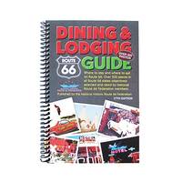
2015Best.-Nr. 1-0988924609National Historic Route 66 Federation 2015. Spiral-bound. New. 17th edition. 206 pages. 8.40x5.50x0.50 inches. National Historic Route 66 Federation unknown
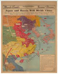
1940Best.-Nr. 209821Los Angeles.: Los Angeles Examiner. 1940. Printed colour pictorial map on a single newspaper leaf 42.3 x 39.9 cms; 54.3 x 42.5 cms sheet archivally laid down on linen slight discolouration to lower centrefold and sheet slightly age-toned but in very good condition. A striking geopolitical map by Los Angeles Examiner artist Howard Burke covering China Japan Southern Russia and the northern part of French Indochina and Siam showing how the "Aggressors Divide China." Areas under Japanese occupation are shown in red and their naval blockade shown by an arc of naval vessels with vivid arrows indicating lines of supply. Text labels including sources of agricultural and raw materials provide a dynamic overview of the geopolitical situation and show the influence of American scientific illustrator and cartographer Richard Edes Harrison who argued for examining geographic issues from multiple perspectives and Los Angeles Times artist Charles Owens. . Los Angeles Examiner. unknown
Best.-Nr. SONG0849333229Used: Good unknown
1768Best.-Nr. 37052Nueva impresión corregida 2ª Ed.- En Madrid: En la Imprenta de Andrés Ramírez con licencia Año MDCCLXVIII 1768.- 2 Vols. 16 h. 499 p.; 2 h. 708 p. i.e. 608 ya que por error se saltaron una centena; 4º menor 215 cm; Tela moderna hacia 1930 en color marfil con tejuelo rojo en lomo.- Este ejemplar es la 1ª reimpresión de esta obra en realidad la 2ª Edición y es tan apreciada como la primera ed. que constaba de 3 tomos y se publico en 1748.- MUY RARO. Palau Nº 84422. La página 195 del tomo 1º con un trozo del margen superior restaurado sin afectar texto y pequeñas marcas de humedad en el margen superior de 13 hojas sin que lleguen a tocar la impresión. Da la sensación de que faltan las portadillas aunque los ejemplares que hemos podido cotejar tienen esa misma particularidad ver Google Books o el ejemplar de la Biblioteca Nacional de España. SIGLO XVIII ESPAÑOL Libro en español En la Imprenta de Andrés Ramírez hardcover
1799Best.-Nr. 17589A Paris, chez Jean ; gravé sur une feuille pliante (55,5x86cm), colorié, qui doit dater de juste avant l'avénement de l'Empire car il y a encore le «quay Bonaparte». On relève aussi les rues d'Arcole, du Contrat Social, du Caire, et, plus curieux, l'existence encore signalée du Palais du Conseil des 500 pourtant dissous le 9 novembre 1799.
2006Best.-Nr. CBS-9780387258546Sp Springer 2006. New. Sp Springer unknown
2006Best.-Nr. CBS-9780387258546Sp Springer 2006. New. Sp Springer unknown
Best.-Nr. 2091502135500931Not Available N.A. Soft Cover. Fine. The book is in fine condition. Not Available paperback
1929Best.-Nr. 2110502150304495Daiichishobo 1929. Soft Cover. Fine. Volume: 1 Daiichishobo paperback
Best.-Nr. 009704Portland Oregon. Frank Amato Publications. The books were published between 1993 through 2001. There are 24 books in total the complete series beginning with Volume 1 Number 1 through Volume 6 Number 4. Each book measures 10 x 7 ½. 48 pp. each. Each book is a limited edition and the limitation number for each book ranges between 300 and 500 copies published depending on the title. The natural history of each river angling history well-known personalities who fished them plus beautiful color photos in each book showing the best fly patterns color maps of each river scenic river shots nice trout steelhead and salmon tackle recommendations etc. Each book is authored by a well-known writer with extensive experience fly fishing the rivers described. This is the complete list of titles: Madison River - Silver Creek - Green River - Ausable River - Kenai River - Yakima River - Thompson River - Pere Marquette River - Yellowstone River - Sacramento River - McKenzie River - Miramichi River - Rio Grande River - Clark Fork River - Au Sable River - Crane Prairie Deschutes Headwaters - Rogue River - North Platte River - White River - Delaware River - Henry's Fork - Salmon River - Big Hole River - Penn's Creek. Each book is bound in gray cloth with gilt titles and all have beautiful pictorial dust jackets. Many of the titles are now scarce in the limited edition format and a complete set is as scarce as hen's teeth. A beautiful set. All in fine condition in fine dust jackets. hardcover
Best.-Nr. DADAX0966342607New unknown
1806Best.-Nr. 009589London: Printed for Richard Phillips Sold By Souter No. 1 Pater-noster-row. 1806. Book. Very Good. Hardcover. First Edition. Large 4to. A very good "large paper" copy with uncut edges leaf size approximately 285mm x 225mm with a few additional items bound in. Pp. xiv 2 530 ii ii. 16 hand-tinted aquatints of which several folding map plus an additional contemporary hand-coloured map of Ireland as frontispiece. Contents: frontispiece quarto format map - engraved for the Poem of Erin. The folding plate of Dublin shown as the frontispiece in the "Directions for Placing the Plates" has been bound in opposite the first page of text title page dedication prefacecontents errata directions for placing the engravings main body of the text additional page on St. Patrick from "Guide to Knowledge" bound in at rear before the Publisher's adverts cutting from the Times 1842 entitled "Robert Emmet and the Gaoler of Kilmainham" pasted to rear paste-down. Original paper-covered boards with recent pebbled cloth spine to match original with the original paper title-label applied to the spine binding in very good condition. Contents very good the uncut edges are a little worn in places and a couple of a small near-contemporary oval stamps of the "Baptist College Bristol" to the front end paper no other marks. Paper in very good condition without any obvious staining minimal foxing almost completly confined to the tissue guards maps and plates all very good clean and crisp short repaired tear to the edge of page 318 not nearly affecting the text. A very good to fine copy. Printed for Richard Phillips, Sold By Souter, No. 1, Pater-noster-row. Hardcover
Best.-Nr. DADAX0195039602New unknown
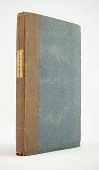
1823Best.-Nr. ST20595London: Longman Hurst Rees Orme and Brown 1823. Seventh Edition. 237 x 145. 9 3/8 x 5 3/4". 3 p.l. vii 1 viii 1 6-236 pp. Publisher's blue paper boards and brown paper backstrip original printed paper label EDGES UNTRIMMED AND MOSTLY UNOPENED. A Large Paper Copy. Just the faintest evidence of foxing at very beginning and very end corners with slight wear as always superficial chafing to covers but AN EXCEPTIONALLY FINE COPY the binding remarkably clean and with no significant signs of use and the wide-margined text unusually fresh and nearly as white as snow. In its original boards untrimmed and partly unopened this is a wonderful contemporary copy of an important later edition of the magnum opus of a man whose name came to be synonymous with road improvement. DNB tells us that Scottish-born John Loudon McAdam 1756-1836 was "the first systematic builder and administrator of roads in Britain since Roman times" and his impact was so great that his name lives on to the present day in connection with paved surfaces. The use of "macadam" or "macadamized" to mean a good road surface began in the 1820s and continued through the invention of the automobile when dusty roads began to be improved with tar. At first "tar" was combined with "macadam" producing the term "tarmacadam" when referring to these improved roads; eventually this became shortened to "tarmac" which still is broadly understood to refer to road surfaces and more specifically to airport runways. Our author first published "Remarks on the Present System of Road Making" in 1816 to deliver his suggestions for an improved paving method following his extensive survey of the roads of Britain. His system--in which roads were built with a cambered surface for drainage using layers of consistent sizes of stones and gravel--soon caught on both within Britain and abroad. The present seventh edition features a variety of new material much of which deals with McAdam's efforts to encourage legislation for improving roads; this includes a new preface and advertisement as well as the "Minutes of Evidence" given by witnesses regarding turnpike improvement from March to May 1819 and the report of the Select Committee of the House of Commons on McAdam's system from June 1823. As evidenced by its appearance in multiple printings McAdam's "Remarks" was a widely used book but our remarkably well-preserved copy in its publisher's boards--obviously and decidedly--was not. Longman, Hurst, Rees, Orme, and Brown unknown
1823Best.-Nr. ST20595London: Longman Hurst Rees Orme and Brown 1823. Seventh Edition. 237 x 145. 9 3/8 x 5 3/4". 3 p.l. vii 1 viii 1 6-236 pp. Publisher's blue paper boards and brown paper backstrip original printed paper label EDGES UNTRIMMED AND MOSTLY UNOPENED. A Large Paper Copy. Just the faintest evidence of foxing at very beginning and very end corners with slight wear as always superficial chafing to covers but AN EXCEPTIONALLY FINE COPY the binding remarkably clean and with no significant signs of use and the wide-margined text unusually fresh and nearly as white as snow. In its original boards untrimmed and partly unopened this is a wonderful contemporary copy of an important later edition of the magnum opus of a man whose name came to be synonymous with road improvement. DNB tells us that Scottish-born John Loudon McAdam 1756-1836 was "the first systematic builder and administrator of roads in Britain since Roman times" and his impact was so great that his name lives on to the present day in connection with paved surfaces. The use of "macadam" or "macadamized" to mean a good road surface began in the 1820s and continued through the invention of the automobile when dusty roads began to be improved with tar. At first "tar" was combined with "macadam" producing the term "tarmacadam" when referring to these improved roads; eventually this became shortened to "tarmac" which still is broadly understood to refer to road surfaces and more specifically to airport runways. Our author first published "Remarks on the Present System of Road Making" in 1816 to deliver his suggestions for an improved paving method following his extensive survey of the roads of Britain. His system--in which roads were built with a cambered surface for drainage using layers of consistent sizes of stones and gravel--soon caught on both within Britain and abroad. The present seventh edition features a variety of new material much of which deals with McAdam's efforts to encourage legislation for improving roads; this includes a new preface and advertisement as well as the "Minutes of Evidence" given by witnesses regarding turnpike improvement from March to May 1819 and the report of the Select Committee of the House of Commons on McAdam's system from June 1823. As evidenced by its appearance in multiple printings McAdam's "Remarks" was a widely used book but our remarkably well-preserved copy in its publisher's boards--obviously and decidedly--was not. Longman, Hurst, Rees, Orme, and Brown unknown books
1844Best.-Nr. GD012817okBC1S5Manchester: Wetmore & Wallace 1844. Manchester: Wetmore & Wallace Rare Americana 1844 First Printing. 8vo. 16 pages with folding map at rear of wrappers. The folding map titled :Plan and Profile of the Route Surveyed for the Northern Railroad from Concord to Lebanon N.H." measuring approxinately 28" long and 9" wide. The map is in extremely nice condition. The spine shows some wear but remains a very nice copy. A signature of S.Chase" appears on the front wrapper. There is an institional rubber stamp on the margin of page 3. Vermont Historical Society Montpelier Vermont. This report printed by Wetmore & Wallace Printers in Manchester New Hampshire presents the findings of an engineer's survey for the Northern Railroad route. It covers the planned railroad connections between Concord Franklin and complete with Lebanon along the Connecticut River. Published in 1844 this document provides historical insight into the development of New Hampshire early railroad infrastructure and the engineering challenges faced in the region at that time. Scarce copy last auction records 1930. First Printing. Paperback. Good/No Jacket. 8vo - over 7¾" - 9¾" tall. Manchester: Wetmore & Wallace