4.566 Ergebnisse
Best.-Nr. 1475779135.Gpaperback. Good. Access codes and supplements are not guaranteed with used items. May be an ex-library book. paperback
Best.-Nr. 1402080964.Ghardcover. Good. Access codes and supplements are not guaranteed with used items. May be an ex-library book. hardcover
Best.-Nr. 45420203like new. unknown
Best.-Nr. 45196787like new. unknown
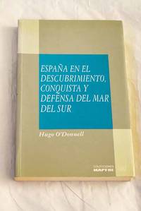
1992Best.-Nr. 3707293Madrid.: MAPFRE. 1992. Paperback. Good. 23 cm. 291 p. il. Encuadernación en tapa blanda de editorial ilustrada. O'Donnell y Duque de Estrada Hugo 1948-. Colección Mar y América. volumen coleccion 6. Ãndices. Piratería. Pacífico Región. Historia. Españoles . ISBN: 847100335X rúst Viajes de descubrimientos. Expediciones 910.4265"15/19" Arte militar en general 355.49265"15/18" MAPFRE. paperback
1924Best.-Nr. 3472377Madrid.: A. Marzo. 1924. Hardcover. Good. 8º mlla. 17 cm. 307 p. 1 h. Encuadernación en tapa dura artesanal con lomo en piel doble tejuelo y nervios. Camino Galicia Julio 1882-1956. Por el Dr. D. Julio Camino Galicia. Grab. intercal . Psicología.159.9 159.9 A. Marzo. hardcover
1934Best.-Nr. 2641068Madrid. 1934. Hardcover. Cubierta deslucida. Good. 8º mllª 17 cm. 34 p. 3 h. Encuadernación en tapa dura de editorial. Estrada Genaro 1887-1937. Jenaro Estrada. Gráficas Marinas . Cubierta deslucida. Literatura.82 82 hardcover
1889Best.-Nr. 2877821Barcelona.: Henrich y compañía. 1889. Hardcover. Cubierta deslucida. contiene pegatina en portada . Good. 22 cm. 88 p. Encuadernación en tapa dura artesanal con lomo en piel. Cubierta deslucida. contiene pegatina en portada . Literatura.82 82 Henrich y compañía. hardcover
1978Best.-Nr. 2734959Vigo.: s.n. 1978. Hardcover. Good. 31 cm. XXIX 141 p. 1 h. pleg. il. Encuadernación en tapa dura artesanal. Guardado en estuche. Estrada Catoira Félix 1853-1938. Por Félix Estrada Catoyra. prólogo y bibliografía de José Mª Alvarez Blázquez. Grafinsa. Vigo. Historia. S. XIX . ISBN: 8470410962 Historia de España. Años 1808 a 14 946.15"1808/14" 946 [s.n.]. hardcover
1958Best.-Nr. 1397491Madrid.: Atlas. 1958. Hardcover. Good. 25 cm. 2 v. Encuadernación en tapa dura artesanal con lomo en piel y doble tejuelo. Flórez Estrada Ãlvaro 1766-1853. Obras. Estudio preliminar y edición de Miguel Artola Gallego. Biblioteca de autores españoles. volumen coleccion t. 112-113. Economía. España. Relaciones económicas. América española. Historia constitucional. Artola Miguel. 1923- . Política económica.338 338 Derecho constitucional. Derecho político. Derecho público. España. 342.446091 342 Atlas. hardcover
1948Best.-Nr. 2536198La Laguna de Tenerife.: Universidad de La Laguna Secretariado de Publicaciones. 1948. Paperback. Cubierta deslucida. Good. 25 cm. VIII 193 p. Encuadernación en tapa blanda de editorial. López Estrada Francisco 1918-2010. Cervantes Saavedra Miguel de. 1547-1616. La Galatea . Cubierta deslucida. Literatura española. Cervantes Saavedra Miguel de 7 Galatea.06 821.134.2 Cervantes Saavedra Miguel de 7 Galatea.06 821.134.2 Universidad de La Laguna, Secretariado de Publicaciones. paperback
1835Best.-Nr. 1101351Madrid.: Imprenta de D. Miguel de Burgos. 1835. Hardcover. Cubierta deslucida. Good. 22 cm. 2 vols. Encuadernación en tapa dura artesanal. Pequeñas notas manuscritas a lápiz en la primera página del tomo I . Cubierta deslucida. Economía.33 33 Imprenta de D. Miguel de Burgos. hardcover
1901Best.-Nr. 1595158La Coruña.: Tip. El Noroeste. 1901. Hardcover. Cubierta deslucida. Good. 23 cm. 2 v. Encuadernación en tapa dura artesanal lomo en piel con dorados. Estrada y Catoira Ramón 1852-1927. Tip. El Noroeste de J. Hernandez Garcia. Con grab. I Nociones de trigonometría y Astronomía ; II Navegación teórica y práctica . Cubierta deslucida. Navegación Tip. El Noroeste. hardcover
1973Best.-Nr. 15351E. Janzer 1973 E. Janzer Barcelona 1973. Encuadernación en rústica con solapas 455 págs. En muy buen estado. 2ª Edición. Encuadernación de tapa blanda. Muy bueno. E. Janzer paperback
Best.-Nr. 6970648like new. unknown
Best.-Nr. 1249958180.Gpaperback. Good. Access codes and supplements are not guaranteed with used items. May be an ex-library book. paperback
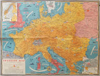
1944Best.-Nr. 206781Toronto.: C.C. Petersen. 1944. Colour pictorial map 51 x 67 cm two small inset maps of Scandinavia and the Baltic and South Greece and the Dodecanese on the verso a black and white world map showing the Pacific Theatre marking keys events of the war and in European world history folding into the original pictorial pocket a little toned and marked 25.8 x 17.7 cm small fold split but in very good condition. A scarce map in the "Dated Events" series published by C.C. Petersen in Canada and distributed throughout North America commemorating D-Day. The colour map by Stanley Turner encompasses the area from England as far south as the French border with Spain and as far east as the USSR and Turkey. "With this invasion map you will be able to follow the progress of the Allied troops on their way to smash Germany.". The text at lower left goes on to elaborate on the features shown on the map from elevation "major battles are seldom fought on the tops of mountains" to pictographs of bombs falling. The black and white map on the verso shows the Far Eastern theatre of war centring on the Pacific Ocean with the Asian landmass including India and the USSR at upper left Australia at lower left and North America and the coast of South America at right of the map. Naval bases are shown and significant events in the war are noted in text boxes. A handsome production of a scarce map rarely seen with the original pictorial pocket. . C.C. Petersen. unknown
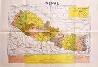
1979Best.-Nr. 207710Dehli.: Indian Book Depot Map House. 1979. Colour map on blush coloured paper 44.2 x 63.6 cms; 53.6 x 75.9 cms sheet inset map of air service routes folding into pictorial card wrappers 25.5 x 19.3 cms issued into colour pictorial paper folder in very good condition. Map shows Nepal and surrounding borders with India Tibet and China provinces picked out in colour international and state boundaries sealed roads railway lines canals lakes springs rivers towns and villages tourist places temples and the inset map shows air services from Nepal to Thailand and India. The rear wrapper shows a view of Pashupatinath Temple the oldest Hindu temple in Kathmandu. . Indian Book Depot (Map House). unknown
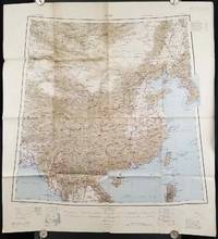
1945Best.-Nr. 206545Calcutta: Compiled and drawn by the Survey of India. Second Edition. 1945. Large folding colour map 77.5 x 80cm; 95.5 x 86.2cm sheet including legend and small inset showing adjoining maps light toning and wear to upper margins and at corners and folds; but in very good condition. Very large clear map of China printed in 1945. The projection is noted as the "Lambert Conical Orthomorphic" a polyconic projection employed by the exhaustive Survey of India and the map includes surrounding countries: Taiwan Korea French Indo-China with a small inset key to Korean place-name abbreviations. As is typical of maps of this period Arunachal Pradesh is shown as Tibetan territory.The legend lists borders and provinces railways roads and canals with topography indicated with colouration. . Compiled and drawn by the Survey of India. unknown
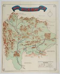
1930Best.-Nr. 206841Kofu.: Onkodo Printing Co. circa1930s. Colour pictorial map 70.2 x 56 cms; 75.5 x 59.5 cms sheet light wear along the inner margin some soft creases from folding short split at center fold; in very good clean condition. An appealing and decorative map of Yamanashi Prefecture which while a process print has the attractive soft look of a lithograph adorned with vignettes of key attractions landmarks such as Mt. Fuji and industry such as silk and wine. The legend lists Railways 'Footing' Roads Hot Springs Hotels and National Parks. A scarce and attractive English language map for the tourist market. . Onkodo Printing Co., unknown
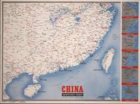
1945Best.-Nr. 194660New York.: Army Information Branch. Volume III No. 51F. 9 April1945. Folding colour map and six inset maps in a vertical panel 88 x 119 cms sheet and on the recto circular map of Europe smaller inset map of Asia and of the Ryukyu Islands descriptive text original folds in very good bright condition. Scarce Newsmap of "China Southeast Coast" from Shanghai to French Indochina with the islands of Formosa and Hainan. At the right edge are inset maps of the vicinities of Shanghai Wenchow Foochow Swatow Canton and Hong Kong. On the verso is a large map of the European theatre of operations centred on Berlin a map of the Pacific area noting the American occupation of Okinawa with a detailed map of this island. In unusually fine bright condition. . Army Information Branch. unknown
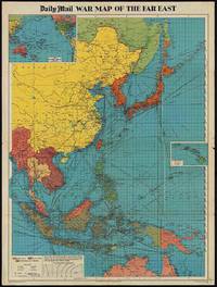
1944Best.-Nr. 205765London.: George Philip & Son. 1944. Full colour folding map 101.5 x 76cm sheet inset maps legend folding into title wrapper 25.7 x 19.4 cm covers a little dusty and discoloured a few short fold splits without loss but the map in very good bright condition. Map of the Pacific Theatre of World War II with borders drawn as they stood in 1937 - complete with Chinese claims on Mongolia Tuva and Tibet. Shows transportation routes principal railways oil fields Allied naval bases territory occupied by the British Empire French Empire and the United States. This map shows only the northernmost section of Australia which allows for much better detail of the countries of East Asia. Small inset map of the Hawaiin Islands at mid right. Inset map of the Pacific Ocean at upper left. . George Philip & Son. unknown
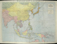
1940Best.-Nr. 205763London.: Hutchinson & Co. Circa1940. Full colour folding map 70.7 x 93 cms; 76 x 101.2 cms sheet original folds short fold splits previous owner's neat title markings on the verso but the map in very good condition. A "Geographia" map of the war theatre in Asia and the Pacific including the northernmost coast of Australia. Showing railways and canals roads and steamer routes oilfields and pipe lines and a key to the unfederated states of Malaya. The Spratley Islands are marked as French and Thai territorial claims within French Indo China are marked. . Hutchinson & Co. unknown
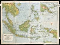
1940Best.-Nr. 211106Sydney.: H.E.C. Robinson Pty. Ltd. circa1940. Full colour folding map 71 x 97 cms; 76.2 x 10² cms sheet blank on verso save for a neat inked stamp "East Indies" inset map of New Guinea and Papua heights shown by colour very good clean condition. Large scale World War II era map by Sydney publisher H. E. C. Robinson. Extremely detailed map it is coloured according to height above sea level and showing naval bases railways shipping routes air routes. Includes smaller inset map of "New Guinea & Papua" showing the eastern part of the island. . H.E.C. Robinson Pty. Ltd. unknown
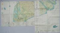
1967Best.-Nr. 203840Washington D.C.: Army Map Service. 1967. Two printed colour adjoining maps 73 x 55.6 cms and 55.6 x 73 cm original folds inked operational annotations to the Quan Long sheet multiple marginal legends noting aerodromes and radio facilities roads railroads and boundaries glossary of terms much of the text is in both English and Vietnamese in very good condition. Detailed U. S. Army maps of the Mekong Delta and Southern Vietnam extending from Rach Gia in the north to the area just south of Quan Long Ca Mau in the south and east including BacLieu and CanTho. The island of Con son is at lower right of the Khanh Hu'ng sheet. Operational notes are inked around Quan Long are marked and the U Minh Forest the impenetrable "forest of darkness" is noted in ink. . . Army Map Service. unknown