2007rif. 2090202120700046Sojusha Art Publishing 2007. Soft Cover. Fine. Number of pages: 195 pages Size: A5 size Sojusha Art Publishing paperback
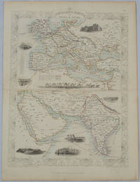
1850rif. 177525London.: The London Printing and Publishing Company. circa1850s. Lithographed map with original outline hand colour 33 x 24.5 cm including border and captions seven vignette illustrations two reference keys decorative border central fold light toning mainly at the central fold and to the verso of the sheet in very good condition preserved in a window mount. Attractive decorative map with fine vignettes of the London Post Office Suez Bombay Madras. Aden Malta Gibraltar and a wonderful camel train led by a carriage and horses crossing North Africa originally by the great mapmaker and publisher John Tallis. The two reference keys note steam packet routes railways electric telegraph and the Suez Canal. . The London Printing and Publishing Company. unknown
1947rif. 2082702114902490Kogyo News Agency Publishing Department 1947. Soft Cover. Fine. Number of pages: 59p Size: A5 Number of books: 1 Kogyo News Agency Publishing Department paperback
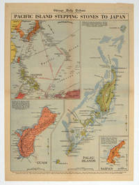
1944rif. 208880Chicago.: Chicago Daily Tribune. 28 September1944. Colour pictorial map on a single newspaper leaf archivally laid down on linen 50 x 39.2 cms; 59.3 x 43.3 cms sheet including captions faint toning to fold lines very good condition. Vivid colour maps of the Palau Islands Guam and Saipan in the Marianas and an inset location map published in the "Chicago Daily Tribune" in September 1944 months after the landing of US and Allied Forces in the offensive against the Japanese during the Pacific War. . Chicago Daily Tribune. unknown
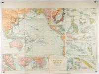
1930rif. 205997Sydney: H.E.C. Robinson. Circa1930s. Printed colour maps in all 65.5 x 99cm the main map roughly 50 x 65 cm on a single sheet 76 x 101.3 cms; a little carelessly folded decorative blue title cover a little dusty and a few fold splits and edgewear but in good condition. The exceptional feature of this map are the twenty six large scale inset maps of Pacific islands including: Malay States Singapore Hong Kong these at lower left Japan Philippine Islands Hawaiian Islands Fiji Solomon Islands Western and Eastern Samoa Tahiti Saipan New Caledonia and Dependencies and many others. The main map of the Pacific Ocean stretches from Southeast Asia including all of Australia and New Zealand the west coast of the Americas the Kamchatka Peninsula Manchukuo Manchuria and most of China. Korea and Taiwan are marked as Japanese Territory. Possessions of Britain France the Netherlands and the United States are highlighted. An incredibly rich source of information on the Pacific theatre during the years leading up to World War II. From the Sydney publisher H.E.C. Robinson the firm founded in 1895 by Herbert Robinson 1857-1933 a founder of the Royal Geographical Society of Australasia. . H.E.C. Robinson. unknown
1920rif. G59838Montevideo, Libreria Cervantes 1920 143pp.+ frontispice, br.orig., 22cm., peu de taches d'humidité, sur papier de luxe, cachet, sinon en bon état
rif. 6071610613.Gpaperback. Good. Access codes and supplements are not guaranteed with used items. May be an ex-library book. paperback
rif. 1402080964.Ghardcover. Good. Access codes and supplements are not guaranteed with used items. May be an ex-library book. hardcover
rif. 1475779135.Gpaperback. Good. Access codes and supplements are not guaranteed with used items. May be an ex-library book. paperback
2004rif. DADAX1402080964Springer 2004-06-15. 2004. hardcover. New. 6.24x0.76x9.50. Buy with confidence. Excellent Customer Service & Return policy. Springer hardcover
2004rif. SONG1402080964Springer 2004-06-15. 2004. hardcover. Used: Good. 6.24x0.76x9.50. Buy with confidence. Excellent Customer Service & Return policy. Springer hardcover
2013rif. x-1475779135Springer 2013. Paperback. New. 253 pages. 9.25x6.10x0.58 inches. Springer paperback
rif. 1300198575.Ghardcover. Good. Access codes and supplements are not guaranteed with used items. May be an ex-library book. hardcover
rif. 8470394002.Gpaperback. Good. Access codes and supplements are not guaranteed with used items. May be an ex-library book. paperback
1953rif. biblio664Overall size is about 31 1/2" X 21". Map has some creasing and the top left corner has some crinkling. Includes a full size Map of Havana A Map of Marianao Interesting Places in Marianao Map of the Gulf of Mexico City of Havana Streets. Ships First Class with Delivery Confirmation. Ucar Garcia, S. A. paperback
2025rif. SKU1734013Timber Press 2025-03-11. hardcover. New. 7x0x10. New Textbook Ships with Tracking Timber Press hardcover
2025rif. SKU1728596Timber Press 2025-03-11. hardcover. New. 7x0x10. New Book Ships with Tracking Timber Press hardcover
rif. 048463741X.Ghardcover. Good. Access codes and supplements are not guaranteed with used items. May be an ex-library book. hardcover
rif. 1333456964.Gpaperback. Good. Access codes and supplements are not guaranteed with used items. May be an ex-library book. paperback
2014rif. ABE-1693438866884ROMAIN DURIS L'HOMME FATAL-FRANCOIS HOLLANDE FACE AUX FRANCAIS-BARRAGE CONTRE LES PACIFIQUES-ROUTE DU RHUM CAP SUR LA PEUR-BURKINA FASO LA CHUTE DE BLAISE COMPAORE-JOHNNY "LAETICIA M'AIME POUR LES BONNES RAISONS"-COMITE COLBERT LES MEILLEURS AMBASSADEURS DE LA FRANCE-LE MYSTERE JOHN CANTLIE-MARLENE JOBERT SOUVENIRS SOUVENIRS-LA CORDEE FANTASTIQUE-SCOTT EASTWOOD TEL PERE TEL FILS-ALISON TEAL-MARTINE ROTHBLATT-LE JOUR OU: YANN QUEFFELEC-(EM723)
1946rif. 1595Lesot André 1946 approx.
1972rif. 29828RCA 1972
1915rif. 28720Partitions sur la Première guerre Mondiale Boyer Lucien 1915 approx.
1984rif. 3791984 - broché - Editions Road Movies / Greno - 1984 - In-8 (24 x 19 cm) - 511 pages - Nombreuses photographies en couleurs et en noir et blanc - ISBN : 3-921568-11-0 / 9783921568118 - Ouvrage trilingue français, allemand et anglais - Paris, Texas est un drame ouest-germano-français réalisé par Wim Wenders, sorti en 1984. Il obtient la Palme d'or au Festival de Cannes 1984.
2002rif. 116613Transboreal 2002 Transboreal, 2002, 429 p., broché, bon état.