4566 risultati
19874to., First Edition thus, with numerous photographs throughout; ivory cloth, backstrip lettered in red, a near fine copy in unclipped dustwrapper. First published in Italy in 1985.
1999rif. 026541Museo de Arte Alvar y Carmen T. de Carrillo Gil 1999. Book. Very Good. Stiff Wrappers. 178 pages. Color illustrations. Some fading to the paper spine. Wear to the cover and edges. Text is in Spanish. List of Works. . Museo de Arte Alvar y Carmen T. de Carrillo Gil paperback
1988rif. 037005Ecuador: Ecuadorian Orchid Society 1988. Soft cover. Very Good. Quarto. Some foxing. Text in Spanish and English. Shipped from the Calico Cat Bookshop a brick and mortar bookshop established in 1975. Ecuadorian Orchid Society paperback
1988rif. Alibris.0033949Asociación Ecuatoriana de Orquideología. 1988. Trade paperback. Very good. light cover wear owner's stamp inside front cover & on 1st blank page owner's name & date on 1st blank page. 129 p. Includes: illustrations index. Asociación Ecuatoriana de Orquideología paperback
1983rif. 798221983 Ed. Robert Laffont - 1983 - in-8 broché - 208 pages
rif. 8014Robert Laffont In-8,broché,209 pages,fané et en bon état d'usage : Bon ensemble .
2014Fine Portuguese Original imitation brown leather bdg. Gilded titles in Turkish, Spanish and Portuguese on the front board. Roy. 8vo. (23 x 16 cm). In Spanish, Portuguese, Arabic, and modern and old (Ottoman) Turkish (with Arabic letters). 238, 192, [2] p. pp. 192 facsimile in Ottoman script, and Arabic translation; pp. 1-238 translations into Portuguese, Spanish and Turkish with Latin alphabet. The first Ottoman travel account and ocean voyage into Brazil. This book has Spanish and Portuguese translations of this voyage as well as modern Turkish with facsimile of original text printed in 1871 [AH 1288] in Ottoman script. Ottoman qadi (judge) Abdurrahman Effendy's voyage to Brazil. First Edition, thus in this edition including multiple translations.
2005rif. 2083002115710595Melkumar Osho Art Unity 2005. Soft Cover. Fine. Number of pages: 552p Size: 21cm Number of books: 1 Melkumar Osho Art Unity paperback
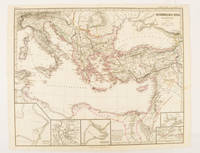
rif. 174950Gotha.: Justus Perthes. Map with original colour and outline hand-colour 32.2 x 40 cm text in German five inset maps central fold slight marginal toning and spotting on the verso but in very good condition. A most handsome and highly detailed map detailing the Eastern provinces of the Byzantine/Roman Empire in the time of the Roman Emperor Justinian 527-565. The inset maps depict Carthage Rome Constantinople Naples and a Western continuation of the main map originally issued for the "Hand-Atlas für die Geschichte des Mittelatters und die Neueren Zeit" . Justus Perthes. unknown
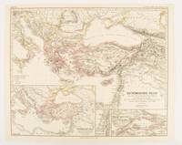
1874rif. 174914Gotha: Justus Perthes. 1874. Map with original colour and outline hand-colour 32.2 x 40 cm three inset maps text in German central fold slight marginal toning in very good condition. A most handsome map detailing the Eastern Roman Empire from the immigration of Hungarians in Ponnonia around 895 to the subjugation of the Bulgarian Empire by Emperor Basilius in 1019. The inset maps depict Divisions of the Empire Palestine and the Themata around Propontis present day Sea of Marmara issued for the "Hand-Atlas für die Geschichte des Mittelatters und die Neueren Zeit". . Justus Perthes unknown
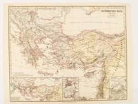
1876rif. 174911Gotha: Justus Perthes. 1876. Map with original colour and outline hand-colour 32.2 x 40 cm text in German four inset maps central fold slight marginal toning and spotting on the verso but in very good condition. A most handsome and highly detailed map detailing the Eastern provinces of the Byzantine/Roman Empire before the Fourth Crusade. The inset maps depict Constantinople Divisions of the Empire and Antioch issued for the "Hand-Atlas für die Geschichte des Mittelatters und die Neueren Zeit" . Justus Perthes unknown
2007rif. 2090202120700046Sojusha Art Publishing 2007. Soft Cover. Fine. Number of pages: 195 pages Size: A5 size Sojusha Art Publishing paperback
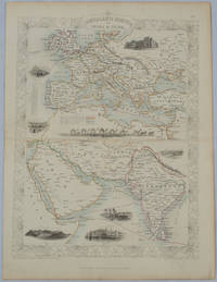
1850rif. 177525London.: The London Printing and Publishing Company. circa1850s. Lithographed map with original outline hand colour 33 x 24.5 cm including border and captions seven vignette illustrations two reference keys decorative border central fold light toning mainly at the central fold and to the verso of the sheet in very good condition preserved in a window mount. Attractive decorative map with fine vignettes of the London Post Office Suez Bombay Madras. Aden Malta Gibraltar and a wonderful camel train led by a carriage and horses crossing North Africa originally by the great mapmaker and publisher John Tallis. The two reference keys note steam packet routes railways electric telegraph and the Suez Canal. . The London Printing and Publishing Company. unknown
1947rif. 2082702114902490Kogyo News Agency Publishing Department 1947. Soft Cover. Fine. Number of pages: 59p Size: A5 Number of books: 1 Kogyo News Agency Publishing Department paperback
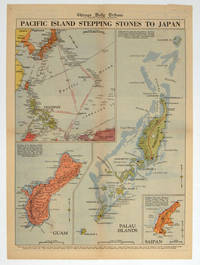
1944rif. 208880Chicago.: Chicago Daily Tribune. 28 September1944. Colour pictorial map on a single newspaper leaf archivally laid down on linen 50 x 39.2 cms; 59.3 x 43.3 cms sheet including captions faint toning to fold lines very good condition. Vivid colour maps of the Palau Islands Guam and Saipan in the Marianas and an inset location map published in the "Chicago Daily Tribune" in September 1944 months after the landing of US and Allied Forces in the offensive against the Japanese during the Pacific War. . Chicago Daily Tribune. unknown
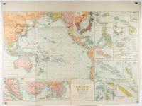
1930rif. 205997Sydney: H.E.C. Robinson. Circa1930s. Printed colour maps in all 65.5 x 99cm the main map roughly 50 x 65 cm on a single sheet 76 x 101.3 cms; a little carelessly folded decorative blue title cover a little dusty and a few fold splits and edgewear but in good condition. The exceptional feature of this map are the twenty six large scale inset maps of Pacific islands including: Malay States Singapore Hong Kong these at lower left Japan Philippine Islands Hawaiian Islands Fiji Solomon Islands Western and Eastern Samoa Tahiti Saipan New Caledonia and Dependencies and many others. The main map of the Pacific Ocean stretches from Southeast Asia including all of Australia and New Zealand the west coast of the Americas the Kamchatka Peninsula Manchukuo Manchuria and most of China. Korea and Taiwan are marked as Japanese Territory. Possessions of Britain France the Netherlands and the United States are highlighted. An incredibly rich source of information on the Pacific theatre during the years leading up to World War II. From the Sydney publisher H.E.C. Robinson the firm founded in 1895 by Herbert Robinson 1857-1933 a founder of the Royal Geographical Society of Australasia. . H.E.C. Robinson. unknown
1920rif. G59838Montevideo, Libreria Cervantes 1920 143pp.+ frontispice, br.orig., 22cm., peu de taches d'humidité, sur papier de luxe, cachet, sinon en bon état
rif. 6071610613.Gpaperback. Good. Access codes and supplements are not guaranteed with used items. May be an ex-library book. paperback
rif. 1402080964.Ghardcover. Good. Access codes and supplements are not guaranteed with used items. May be an ex-library book. hardcover
rif. 1475779135.Gpaperback. Good. Access codes and supplements are not guaranteed with used items. May be an ex-library book. paperback
2004rif. DADAX1402080964Springer 2004-06-15. 2004. hardcover. New. 6.24x0.76x9.50. Buy with confidence. Excellent Customer Service & Return policy. Springer hardcover
2004rif. SONG1402080964Springer 2004-06-15. 2004. hardcover. Used: Good. 6.24x0.76x9.50. Buy with confidence. Excellent Customer Service & Return policy. Springer hardcover
2013rif. x-1475779135Springer 2013. Paperback. New. 253 pages. 9.25x6.10x0.58 inches. Springer paperback
rif. 1300198575.Ghardcover. Good. Access codes and supplements are not guaranteed with used items. May be an ex-library book. hardcover
rif. 8470394002.Gpaperback. Good. Access codes and supplements are not guaranteed with used items. May be an ex-library book. paperback